What is aDrone?
Drone is a relatively small size remote controlled or automatic pilotless
aircraft.
Advantages Disadvantages
• Cheap and cost effective
• High spatial resolution
• High accuracy
• Easier to deploy
• No hindrances from clouds
• A great tool for surveillance
• Limited capabilities and coverages
• Care required to use in populated areas
• Chances of misuse due to easy
operation
3.
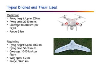
Types Drones andTheir Uses
Multirotor
Flying height: Up to 500 m
Flying time: 20-30 mins.
Coverage: 0.4-0.8 km2 per
flight
Range: 5 km
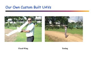
Fixed-wing
Flying height: Up to 1,000 m
Flying time: 50-60 mins.
Coverage: 10-40 km2 per
flight
Wing span: 1-2 m
Range: 30-60 km
4.
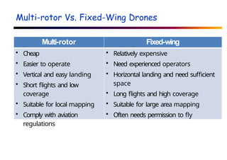
Multi-rotor Vs. Fixed-WingDrones
Multi-rotor Fixed-wing
• Cheap
• Easier to operate
• Vertical and easy landing
• Short flights and low
coverage
• Suitable for local mapping
• Comply with aviation
regulations
• Relatively expensive
• Need experienced operators
• Horizontal landing and need sufficient
space
• Long flights and high coverage
• Suitable for large area mapping
• Often needs permission to fly
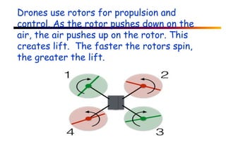
Drones use rotorsfor propulsion and
control. As the rotor pushes down on the
air, the air pushes up on the rotor. This
creates lift. The faster the rotors spin,
the greater the lift.
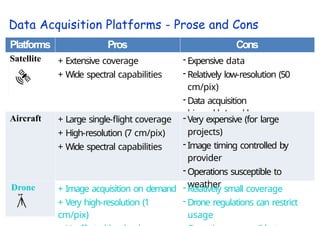
Data Acquisition Platforms- Prose and Cons
Platforms Pros Cons
Satellite + Extensive coverage
+ Wide spectral capabilities
- Expensive data
- Relatively low-resolution (50
cm/pix)
- Data acquisition
bi-weekly/weekly
Aircraft + Large single-flight coverage
+ High-resolution (7 cm/pix)
+ Wide spectral capabilities
- Very expensive (for large
projects)
- Image timing controlled by
provider
- Operations susceptible to
weather
Drone + Image acquisition on demand
+ Very high-resolution (1
cm/pix)
- Relatively small coverage
- Drone regulations can restrict
usage
12.
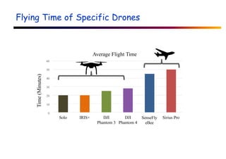
Flying Time ofSpecific Drones
60
50
40
30
20
10
0
Solo IRIS+ DJI DJI
Phantom 3 Phantom 4
SenseFly
eBee
Sirius Pro
Average Flight Time
Time
(Minutes)
13.
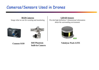
Cameras/Sensors Used inDrones
RGB Cameras
Image what we see for scouting and monitoring
LiDAR Sensors
Provide high definition 3-dimensional information
about the surrounding environment
DJI Phantom
built-in Camera
Valodyne Puck LITE
Cannon S110
14.
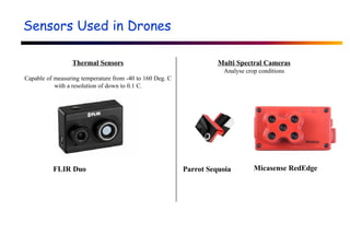
Sensors Used inDrones
Thermal Sensors
Capable of measuring temperature from -40 to 160 Deg. C
with a resolution of down to 0.1 C.
Multi Spectral Cameras
Analyse crop conditions
Parrot Sequoia Micasense RedEdge
FLIR Duo
15.
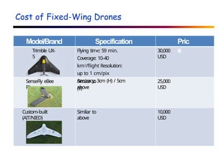
Cost of Fixed-WingDrones
Model/Brand Specification
s
Pric
e
Trimble UX-
5
Flying time: 59 min.
Coverage: 10-40
km2/flight Resolution:
up to 1 cm/pix
Accuracy: 3cm (H) / 5cm
(V)
30,000
USD
SenseFly eBee
Plus
Similar to
above
25,000
USD
Custom-built
(AIT/NIED)
Similar to
above
10,000
USD
16.
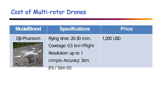
Cost of Multi-rotorDrones
Model/Brand Specifications Price
DJI-Phantom Flying time: 20-30 min.
Coverage: 0.5 km2/Flight
Resolution: up to 1
cm/pix Accuracy: 3cm
(H) / 5cm (V)
1,200 USD
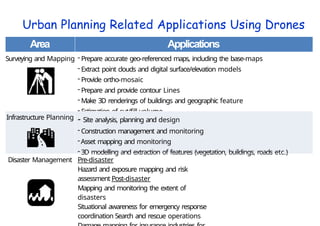
Urban Planning RelatedApplications Using Drones
Area Applications
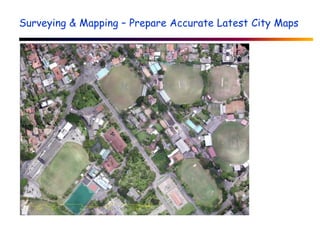
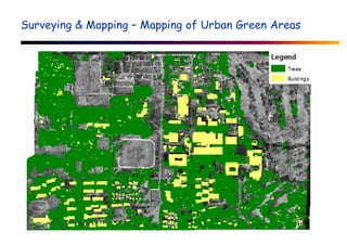
Surveying and Mapping - Prepare accurate geo-referenced maps, including the base-maps
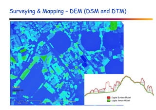
- Extract point clouds and digital surface/elevation models
- Provide ortho-mosaic
- Prepare and provide contour Lines
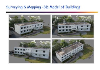
- Make 3D renderings of buildings and geographic feature
- Estimation of cut/fill volume
Infrastructure Planning - Site analysis, planning and design
- Construction management and monitoring
-Asset mapping and monitoring
- 3D modelling and extraction of features (vegetation, buildings, roads etc.)
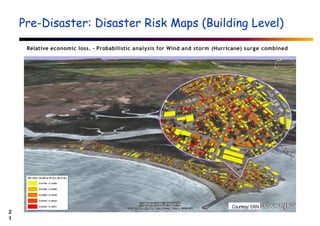
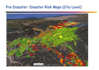
Disaster Management Pre-disaster
Hazard and exposure mapping and risk
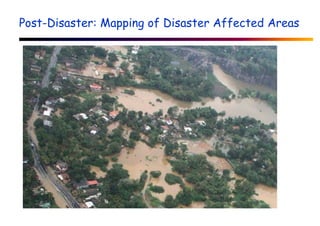
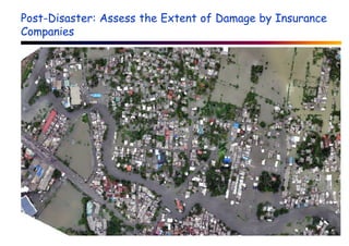
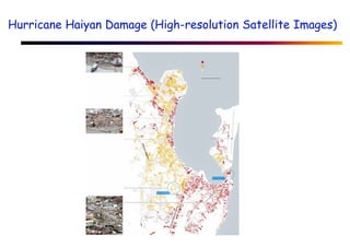
assessment Post-disaster
Mapping and monitoring the extent of
disasters
Situational awareness for emergency response
coordination Search and rescue operations
2
0
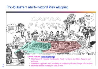
Pre-Disaster: Multi-hazard RiskMapping
CAPRA Features (www.ecapra.org)
• Multi-hazard (6 Hazards - Earthquake, Flood, Hurricane, Landslide, Tsunami and
Volcano)
• Probabilistic approach with possibility of integrating Climate Change information
• Informed decision making on basis of risk