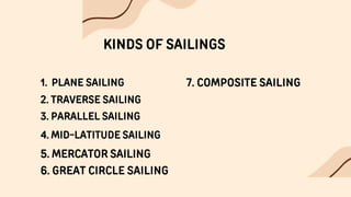
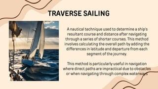
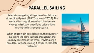
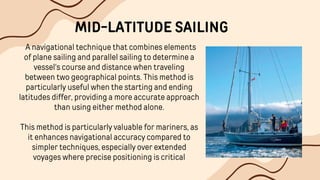
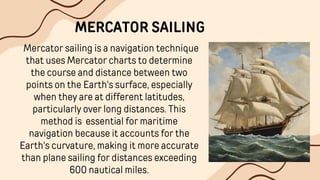
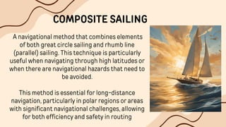
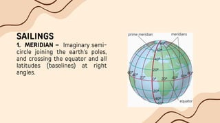
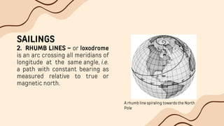
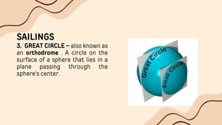
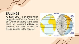
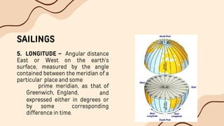
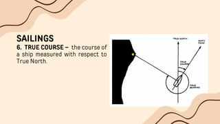
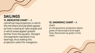
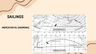
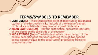
NAV-IIl
SAILING
INTRODUCTION
Dead Reckoning involves the determination of one’s present or
future position by projecting the ship’s course and distance run
from a known position.
A closely related problem is that of finding the course and distance
from one known point to another known point.
INTRODUCTION
For short distances, these problems are easily solved directly on
charts, but for long distances, a purely mathematical solution is
often a better method.
Collectively, these methods are called THE SAILINGS
KINDS OF SAILINGS
1. PLANE SAILING
2. TRAVERSE SAILING
3. PARALLEL SAILING
4. MID-LATITUDE SAILING
5. MERCATOR SAILING
6. GREAT CIRCLE SAILING
7. COMPOSITE SAILING
PLANE SAILING
Plane sailing is an approximate method
of navigation used for short distances,
where the Earth's curvature is neglected,
This technique assumes a flat Earth
model, allowing navigators to simplify
calculations by treating the navigation
path as a right triangle. This method is
suitable for distances up to a few
hundred miles.
TRAVERSE SAILING
A nautical technique used to determine a ship's
resultant course and distance after navigating
through a series of shorter courses. This method
involves calculating the overall path by adding the
differences in latitude and departure from each
segment of the journey.
This method is particularly useful in navigation
where direct paths are impractical due to obstacles
or when navigating through complex waterways
PARALLEL SAILING
Refers to navigating along a constant latitude,
either directly east (090° T) or west (270° T). This
method is straightforward as it involves no
change in latitude, simplifying calculations
related to distance and course.
When engaging in parallel sailing, the navigator
maintains the same latitude throughout the
journey. This means the vessel travels along a
parallel of latitude, making it easier to calculate
distances
MID-LATITUDE SAILING
A navigational technique that combines elements
of plane sailing and parallel sailing to determine a
vessel's course and distance when traveling
between two geographical points. This method is
particularly useful when the starting and ending
latitudes differ, providing a more accurate approach
than using either method alone.
This method is particularly valuable for mariners, as
it enhances navigational accuracy compared to
simpler techniques, especially over extended
voyages where precise positioning is critical
Mercator sailing is a navigation technique
that uses Mercator charts to determine
the course and distance between two
points on the Earth's surface, especially
when they are at different latitudes,
particularly over long distances. This
method is essential for maritime
navigation because it accounts for the
Earth's curvature, making it more accurate
than plane sailing for distances exceeding
600 nautical miles.
MERCATOR SAILING
Great circle sailing is a navigational technique
used to find the shortest path between two
points on the Earth's surface. This method is
particularly important for long-distance ocean
travel, as it takes advantage of the Earth's
spherical shape.
This technique is essential for efficient
navigation across vast distances, ensuring that
vessels and aircraft can optimize their routes
effectively.
GREAT CIRCLE SAILING
A navigational method that combines elements
of both great circle sailing and rhumb line
(parallel) sailing. This technique is particularly
useful when navigating through high latitudes or
when there are navigational hazards that need to
be avoided.
This method is essential for long-distance
navigation, particularly in polar regions or areas
with significant navigational challenges, allowing
for both efficiency and safety in routing
COMPOSITE SAILING
DEFINE THE FOLLOWING
MERIDIAN
1.
RHUMB LINES
2.
GREAT CIRCLE
3.
LATITUDE
4.
LONGITUDE
5.
TRUE COURSE
6.
DISTANCE
7.
DEPARTURE
8.
GREAT CIRCLE TRACK
9.
VERTEX
10.
MERCATOR CHART
11.
GNOMONIC CHART
12.
SAILINGS
1. MERIDIAN – Imaginary semi-
circle joining the earth's poles,
and crossing the equator and all
latitudes (baselines) at right
angles.
SAILINGS
2. RHUMB LINES – or loxodrome
is an arc crossing all meridians of
longitude at the same angle, i.e.
a path with constant bearing as
measured relative to true or
magnetic north.
A rhumb line spiraling towards the North
Pole
SAILINGS
3. GREAT CIRCLE – also known as
an orthodrome . A circle on the
surface of a sphere that lies in a
plane passing through the
sphere's center.
SAILINGS
4. LATITUDE – is an angle which
ranges from 0° at the Equator to
90° (North or South) at the poles.
Lines of constant latitude, or
parallels, run east to west as
circles parallel to the equator.
SAILINGS
5. LONGITUDE – Angular distance
East or West on the earth's
surface, measured by the angle
contained between the meridian of a
particular place and some
Greenwich, England,
prime meridian, as that of
and
expressed either in degrees or
by some corresponding
difference in time.
SAILINGS
6. TRUE COURSE – the course of
a ship measured with respect to
True North.
SAILINGS
7. DISTANCE – The length in
nautical miles of the rhumb line
joining any two places on the
earth's surface.
In the figure, distance is
measured in the chart using
compass dividers and the
Latitude scale.
SAILINGS
8. DEPARTURE – The
distance between two
meridians.
DEP vs. DLO
DLO – Difference between
Longitudes is the angle
between two meridians.
SAILINGS
9. GREAT CIRCLE TRACK –
Because the earth is not
flat, but a sphere (roughly),
the
shortest distance between
two points is not a straight
line, but a curved one.
It is the arc of the great circle
between two points.
The image above shows the difference of
distance between GC and RL (Mercator Track)
SAILINGS
10. VERTEX – The point on
the Great Circle Track where
greatest value of Latitude is
located.
SAILINGS
11. MERCATOR CHART – A
cylindrical map projection in which
the meridians and parallels appear
as lines crossing at right angles and
in which areas appear greater
farther from the equator. Straight
line segments represent true
bearings, thus making this
projection useful for navigation.
12. GNOMONIC CHART – A
chart
on the gnomonic projection where
great circles project as straight
lines. Also known as great-circle
chart.
SAILINGS
MERCATOR VS. GNOMONIC
TERMS/SYMBOLS TO REMEMBER
LATITUDE (L) – The latitude of the point of departure is designated
L₁; that of the destination is L₂; latitude of the vertex of a great
circle is Lv; and latitude of any point on a great circle is Lx
1.
MEAN LATITUDE (Lm) – Half the arithmetical sum of the latitudes
of two places on the same side of the equator
2.
MID LATITUDE (Lm) – The latitude at which the arc length of the
parallel separating the meridians passing through two specific
points is exactly equal to the departure in proceeding from one
point to the other
3.
TERMS TO REMEMBER
DIFFERENCE OF LATITUDE (l or Dlat.)
1.
MERIDIONAL PARTS (M) – The meridional parts of the point of
departure are designed M₁, and the point of arrival or the
destination, M₂
2.
MERIDIONAL DIFFERENCE (m)
3.
LONGITUDE (λ) – The longitude of the point of departure is
designated λ₁; hat of the point of arrival, λ₂; of the vertex of a
great circle, lv; and of any point on a great circle, λx
4.
TERMS TO REMEMBER
DIFFERENCE OF LONGITUDE (Dlo)
1.
DEPARTURE (p or Dep.)
2.
COURSE or COURSE ANGLE (Cn or C)
3.
DISTANCE (D or Dist.)
4.
THANK YOU

Navigation Terrestrial-3-Sailing-.pptx.pdf

  • 1.
  • 2.
    INTRODUCTION Dead Reckoning involvesthe determination of one’s present or future position by projecting the ship’s course and distance run from a known position. A closely related problem is that of finding the course and distance from one known point to another known point.
  • 3.
    INTRODUCTION For short distances,these problems are easily solved directly on charts, but for long distances, a purely mathematical solution is often a better method. Collectively, these methods are called THE SAILINGS
  • 4.
    KINDS OF SAILINGS 1.PLANE SAILING 2. TRAVERSE SAILING 3. PARALLEL SAILING 4. MID-LATITUDE SAILING 5. MERCATOR SAILING 6. GREAT CIRCLE SAILING 7. COMPOSITE SAILING
  • 5.
    PLANE SAILING Plane sailingis an approximate method of navigation used for short distances, where the Earth's curvature is neglected, This technique assumes a flat Earth model, allowing navigators to simplify calculations by treating the navigation path as a right triangle. This method is suitable for distances up to a few hundred miles.
  • 6.
    TRAVERSE SAILING A nauticaltechnique used to determine a ship's resultant course and distance after navigating through a series of shorter courses. This method involves calculating the overall path by adding the differences in latitude and departure from each segment of the journey. This method is particularly useful in navigation where direct paths are impractical due to obstacles or when navigating through complex waterways
  • 7.
    PARALLEL SAILING Refers tonavigating along a constant latitude, either directly east (090° T) or west (270° T). This method is straightforward as it involves no change in latitude, simplifying calculations related to distance and course. When engaging in parallel sailing, the navigator maintains the same latitude throughout the journey. This means the vessel travels along a parallel of latitude, making it easier to calculate distances
  • 8.
    MID-LATITUDE SAILING A navigationaltechnique that combines elements of plane sailing and parallel sailing to determine a vessel's course and distance when traveling between two geographical points. This method is particularly useful when the starting and ending latitudes differ, providing a more accurate approach than using either method alone. This method is particularly valuable for mariners, as it enhances navigational accuracy compared to simpler techniques, especially over extended voyages where precise positioning is critical
  • 9.
    Mercator sailing isa navigation technique that uses Mercator charts to determine the course and distance between two points on the Earth's surface, especially when they are at different latitudes, particularly over long distances. This method is essential for maritime navigation because it accounts for the Earth's curvature, making it more accurate than plane sailing for distances exceeding 600 nautical miles. MERCATOR SAILING
  • 10.
    Great circle sailingis a navigational technique used to find the shortest path between two points on the Earth's surface. This method is particularly important for long-distance ocean travel, as it takes advantage of the Earth's spherical shape. This technique is essential for efficient navigation across vast distances, ensuring that vessels and aircraft can optimize their routes effectively. GREAT CIRCLE SAILING
  • 11.
    A navigational methodthat combines elements of both great circle sailing and rhumb line (parallel) sailing. This technique is particularly useful when navigating through high latitudes or when there are navigational hazards that need to be avoided. This method is essential for long-distance navigation, particularly in polar regions or areas with significant navigational challenges, allowing for both efficiency and safety in routing COMPOSITE SAILING
  • 12.
    DEFINE THE FOLLOWING MERIDIAN 1. RHUMBLINES 2. GREAT CIRCLE 3. LATITUDE 4. LONGITUDE 5. TRUE COURSE 6. DISTANCE 7. DEPARTURE 8. GREAT CIRCLE TRACK 9. VERTEX 10. MERCATOR CHART 11. GNOMONIC CHART 12.
  • 13.
    SAILINGS 1. MERIDIAN –Imaginary semi- circle joining the earth's poles, and crossing the equator and all latitudes (baselines) at right angles.
  • 14.
    SAILINGS 2. RHUMB LINES– or loxodrome is an arc crossing all meridians of longitude at the same angle, i.e. a path with constant bearing as measured relative to true or magnetic north. A rhumb line spiraling towards the North Pole
  • 15.
    SAILINGS 3. GREAT CIRCLE– also known as an orthodrome . A circle on the surface of a sphere that lies in a plane passing through the sphere's center.
  • 16.
    SAILINGS 4. LATITUDE –is an angle which ranges from 0° at the Equator to 90° (North or South) at the poles. Lines of constant latitude, or parallels, run east to west as circles parallel to the equator.
  • 17.
    SAILINGS 5. LONGITUDE –Angular distance East or West on the earth's surface, measured by the angle contained between the meridian of a particular place and some Greenwich, England, prime meridian, as that of and expressed either in degrees or by some corresponding difference in time.
  • 18.
    SAILINGS 6. TRUE COURSE– the course of a ship measured with respect to True North.
  • 19.
    SAILINGS 7. DISTANCE –The length in nautical miles of the rhumb line joining any two places on the earth's surface. In the figure, distance is measured in the chart using compass dividers and the Latitude scale.
  • 20.
    SAILINGS 8. DEPARTURE –The distance between two meridians. DEP vs. DLO DLO – Difference between Longitudes is the angle between two meridians.
  • 21.
    SAILINGS 9. GREAT CIRCLETRACK – Because the earth is not flat, but a sphere (roughly), the shortest distance between two points is not a straight line, but a curved one. It is the arc of the great circle between two points. The image above shows the difference of distance between GC and RL (Mercator Track)
  • 22.
    SAILINGS 10. VERTEX –The point on the Great Circle Track where greatest value of Latitude is located.
  • 23.
    SAILINGS 11. MERCATOR CHART– A cylindrical map projection in which the meridians and parallels appear as lines crossing at right angles and in which areas appear greater farther from the equator. Straight line segments represent true bearings, thus making this projection useful for navigation. 12. GNOMONIC CHART – A chart on the gnomonic projection where great circles project as straight lines. Also known as great-circle chart.
  • 24.
  • 25.
    TERMS/SYMBOLS TO REMEMBER LATITUDE(L) – The latitude of the point of departure is designated L₁; that of the destination is L₂; latitude of the vertex of a great circle is Lv; and latitude of any point on a great circle is Lx 1. MEAN LATITUDE (Lm) – Half the arithmetical sum of the latitudes of two places on the same side of the equator 2. MID LATITUDE (Lm) – The latitude at which the arc length of the parallel separating the meridians passing through two specific points is exactly equal to the departure in proceeding from one point to the other 3.
  • 26.
    TERMS TO REMEMBER DIFFERENCEOF LATITUDE (l or Dlat.) 1. MERIDIONAL PARTS (M) – The meridional parts of the point of departure are designed M₁, and the point of arrival or the destination, M₂ 2. MERIDIONAL DIFFERENCE (m) 3. LONGITUDE (λ) – The longitude of the point of departure is designated λ₁; hat of the point of arrival, λ₂; of the vertex of a great circle, lv; and of any point on a great circle, λx 4.
  • 27.
    TERMS TO REMEMBER DIFFERENCEOF LONGITUDE (Dlo) 1. DEPARTURE (p or Dep.) 2. COURSE or COURSE ANGLE (Cn or C) 3. DISTANCE (D or Dist.) 4.
  • 28.