SlideShare a Scribd company logo
1 of 1
Download to read offline
Models erosion as methodical basis
combating its manifestations in Ukraine
Yuriy Dmytruk, Vasyl Cherlіnka, Yurіy Fedkovych Chernіvtsі Natіonal Unіversіty, Ukraine
INTRODUCTION
The water and wind erosion heading the list of
destructive phenomena concerning of the
soils. The emergence and development of
processes of water erosion is one of the most
urgent problems for the environment of
Ukraine. Erosion is a leading factor in the loss
of the fertile soil layer, that is, its degradation
as a natural and economical resource. It is
relevant even for relatively arid areas, since
the storm-like nature of the precipitation
implies the immediate emergence of
temporary water streams, which determine
the appearance of linear erosion elements. A
detailed analysis carried out by soil scientists
in Ukraine has shown that the combination of
negative factors has a positive dynamic
(Baljuk et al., 2010).
а) b)
Fig. 1. Geographical location of the research area within
Ukraine (a), Chernivtsi region (b)
The foundation of modern advances in the
field of combining erosion models with
geoinformation systems has already been laid,
and these results are theoretical basis for the
practical realization of spatial analysis and
modeling.
MATERIALS AND METHODS
Data processing was carried out with the use
of GIS GRASS (GRASS Development Team,
2017). As object of research, a fragment of the
territory of Ukraine (Fig. 1a) was selected, in
particular the Kitsman district of the
Chernivtsi region (Fig. 1b), is confined to the
Dniester-Prut watershed (Northern Bukovina)
with contrasting geomorphological
conditions.
To create simulation models of soil cover, we
used the Cherlinka script (2017c, d, b) written
on the R-statistic, which includes a number of
adaptations for solving set tasks and
implements 14 basic types of predicative
algorithms. This work used Random Forests,
its implementation in the R ranger package
(Wright and Ziegler, 2017). Based on the
analysis of the DEM (GRASS Development
Team, 2017), we simulated and evaluated the
potential risks of erosion phenomena using
the SIMWE model (Mitas and Mitasova,
1998; Mitasova and Mitas, 2001; Hofierka et
al., 2002; Fernandes et al., 2017). The
parameters of the model were chosen
according to Koko data (2011).
For comparing we are given by erosion
modeling on the example of the typical region
of Ukraine, which is average for all
parameters. As we see (Figure 2a, Table 1),
only 60.3% of its territory is covered by soil
surveys.
MAIN RESULTS
To fill the gaps, we used the Random Forest
algorithm, which them we obtained a
predicative soil map with κ = 87.4% (Fig. 2b).
This allowed us to use these predictive data
for the expansion of the official assessment of
the territory's erosion. If we calculate erosion
only according to official data (we recall that
the data are 60-30 years old), then in general
it is 15862 ha or 26% of the area of the district
(Fig. 2c, Table 1). If we estimate the erosivity
of the soil to give a predicative soil map, then
we see that the erosivity increases by 224%,
with strongly eroded soils occupying almost 2
times more areas (Fig. 2d, Table 1). The area
of the sedimented soils remained at the
previous level. In contrast to the previous
approach the definition of the number of
eroded areas, the next approach is based on a
mathematical model experiment. Simulation
of water erosion based on SIMWE model
showed interesting results.
First of all, it is clearly observed that erosion
processes are timed to the relief of the territory.
Further simulation, allowed to obtain a
complete picture of erosion hazard (Fig. 2e).
This figure shows that the location of eroded
soils on the official maps do not really have the
necessary precision, since they do not take into
account many of the moments associated with
the progress of real erosion processes.
CONCLUSIONS
It has been shown that the existing data on the
development of soil erodibility in Ukraine are
outdated, incomplete and have numerous
errors. An advanced version of the evaluation of
this data, i.e. filling gaps in researches through
predicative soil modeling, although possible,
but can’t be too precise due to incomplete
reliability of the source data. Our research
confirms the effectiveness of using GRASS GIS
and the model of water erosion-deposition
SIMWE for a more correct assessment of the
phenomenon of erosion. This is a prerequisite
for the development of a system of anti-erosion
measures at a qualitatively higher level. It also
allows assessing different scenarios and
strategies to combat the manifestations of
erosion processes. Such an approach is scalable
for the entire territory of Ukraine and may be
recommended for a more accurate assessment
of the risks of erosion.
Tab. 1: Differences between official and model data on soil erosion
Fig. 2. Soil resources of the region of research: map of agro-industrial groups of
soil (a); predicative soil map (b); eroded soils according to official data (c); eroded
soils according to the predicative map (d); erosion-deposition map from SIMWE,
kg∙m-2∙s-1 (e)
a)
d)
b)
c) e)

More Related Content

What's hot

landslide hazard mapping in Ethiopia
landslide hazard mapping in Ethiopialandslide hazard mapping in Ethiopia
landslide hazard mapping in EthiopiaUniversity of Gondar
 
Assessment of landslide susceptibility using geospatial analysis and interfer...
Assessment of landslide susceptibility using geospatial analysis and interfer...Assessment of landslide susceptibility using geospatial analysis and interfer...
Assessment of landslide susceptibility using geospatial analysis and interfer...Pavlos Krassakis
 
SOIL LOSS ESTIMATION IN GIS FRAMEWORK: A CASE STUDY IN CHAMPABATI WATERSHED
SOIL LOSS ESTIMATION IN GIS FRAMEWORK: A CASE STUDY IN CHAMPABATI WATERSHEDSOIL LOSS ESTIMATION IN GIS FRAMEWORK: A CASE STUDY IN CHAMPABATI WATERSHED
SOIL LOSS ESTIMATION IN GIS FRAMEWORK: A CASE STUDY IN CHAMPABATI WATERSHEDAM Publications
 
Assessing 50 years of tropical Peruvian glacier volume change from multitempo...
Assessing 50 years of tropical Peruvian glacier volume change from multitempo...Assessing 50 years of tropical Peruvian glacier volume change from multitempo...
Assessing 50 years of tropical Peruvian glacier volume change from multitempo...InfoAndina CONDESAN
 
Landslide Susceptibility Assessment Using Modified Frequency Ratio Model in K...
Landslide Susceptibility Assessment Using Modified Frequency Ratio Model in K...Landslide Susceptibility Assessment Using Modified Frequency Ratio Model in K...
Landslide Susceptibility Assessment Using Modified Frequency Ratio Model in K...Dr. Amarjeet Singh
 
Structural geology
Structural geologyStructural geology
Structural geologyKhchao Tel
 
GIS and Sensor Based Monitoring and Prediction of Landslides with Landslide M...
GIS and Sensor Based Monitoring and Prediction of Landslides with Landslide M...GIS and Sensor Based Monitoring and Prediction of Landslides with Landslide M...
GIS and Sensor Based Monitoring and Prediction of Landslides with Landslide M...iosrjce
 
Change detection process and techniques
Change detection process and techniquesChange detection process and techniques
Change detection process and techniquesAlexander Decker
 
Kim_WE3_T05_2.pptx
Kim_WE3_T05_2.pptxKim_WE3_T05_2.pptx
Kim_WE3_T05_2.pptxgrssieee
 
Application of Remote Sensing Techniques for Change Detection in Land Use/ La...
Application of Remote Sensing Techniques for Change Detection in Land Use/ La...Application of Remote Sensing Techniques for Change Detection in Land Use/ La...
Application of Remote Sensing Techniques for Change Detection in Land Use/ La...iosrjce
 
A 3d extinction_map_of_the_northern_galactic_plane_based_on_iphas_photometry
A 3d extinction_map_of_the_northern_galactic_plane_based_on_iphas_photometryA 3d extinction_map_of_the_northern_galactic_plane_based_on_iphas_photometry
A 3d extinction_map_of_the_northern_galactic_plane_based_on_iphas_photometrySérgio Sacani
 
GIS-3D Analysis of Susceptibility Landslide Disaster in Upstream Area of Jene...
GIS-3D Analysis of Susceptibility Landslide Disaster in Upstream Area of Jene...GIS-3D Analysis of Susceptibility Landslide Disaster in Upstream Area of Jene...
GIS-3D Analysis of Susceptibility Landslide Disaster in Upstream Area of Jene...AM Publications
 
2. Technical introduction to the GSOC Map
2. Technical introduction to the GSOC Map2. Technical introduction to the GSOC Map
2. Technical introduction to the GSOC MapFAO
 
Change detection analysis in land use / land cover of Pune city using remotel...
Change detection analysis in land use / land cover of Pune city using remotel...Change detection analysis in land use / land cover of Pune city using remotel...
Change detection analysis in land use / land cover of Pune city using remotel...Nitin Mundhe
 
Extreme Precipitation in Greece
Extreme Precipitation in GreeceExtreme Precipitation in Greece
Extreme Precipitation in Greecee_houssos
 
Land Use and Land Cover change monitoring of Surajpur Wetland, Uttar Pradesh:...
Land Use and Land Cover change monitoring of Surajpur Wetland, Uttar Pradesh:...Land Use and Land Cover change monitoring of Surajpur Wetland, Uttar Pradesh:...
Land Use and Land Cover change monitoring of Surajpur Wetland, Uttar Pradesh:...Arnab Saha
 
Egu talk on EcoHydrology by Brenner et al.
Egu talk on EcoHydrology by Brenner et al.Egu talk on EcoHydrology by Brenner et al.
Egu talk on EcoHydrology by Brenner et al.Riccardo Rigon
 

What's hot (20)

landslide hazard mapping in Ethiopia
landslide hazard mapping in Ethiopialandslide hazard mapping in Ethiopia
landslide hazard mapping in Ethiopia
 
Assessment of landslide susceptibility using geospatial analysis and interfer...
Assessment of landslide susceptibility using geospatial analysis and interfer...Assessment of landslide susceptibility using geospatial analysis and interfer...
Assessment of landslide susceptibility using geospatial analysis and interfer...
 
SOIL LOSS ESTIMATION IN GIS FRAMEWORK: A CASE STUDY IN CHAMPABATI WATERSHED
SOIL LOSS ESTIMATION IN GIS FRAMEWORK: A CASE STUDY IN CHAMPABATI WATERSHEDSOIL LOSS ESTIMATION IN GIS FRAMEWORK: A CASE STUDY IN CHAMPABATI WATERSHED
SOIL LOSS ESTIMATION IN GIS FRAMEWORK: A CASE STUDY IN CHAMPABATI WATERSHED
 
DSO Thessaly report_09032021
DSO Thessaly report_09032021DSO Thessaly report_09032021
DSO Thessaly report_09032021
 
Assessing 50 years of tropical Peruvian glacier volume change from multitempo...
Assessing 50 years of tropical Peruvian glacier volume change from multitempo...Assessing 50 years of tropical Peruvian glacier volume change from multitempo...
Assessing 50 years of tropical Peruvian glacier volume change from multitempo...
 
Landslide Susceptibility Assessment Using Modified Frequency Ratio Model in K...
Landslide Susceptibility Assessment Using Modified Frequency Ratio Model in K...Landslide Susceptibility Assessment Using Modified Frequency Ratio Model in K...
Landslide Susceptibility Assessment Using Modified Frequency Ratio Model in K...
 
Structural geology
Structural geologyStructural geology
Structural geology
 
GIS and Sensor Based Monitoring and Prediction of Landslides with Landslide M...
GIS and Sensor Based Monitoring and Prediction of Landslides with Landslide M...GIS and Sensor Based Monitoring and Prediction of Landslides with Landslide M...
GIS and Sensor Based Monitoring and Prediction of Landslides with Landslide M...
 
Change detection process and techniques
Change detection process and techniquesChange detection process and techniques
Change detection process and techniques
 
nigelanstey
nigelansteynigelanstey
nigelanstey
 
Kim_WE3_T05_2.pptx
Kim_WE3_T05_2.pptxKim_WE3_T05_2.pptx
Kim_WE3_T05_2.pptx
 
Application of Remote Sensing Techniques for Change Detection in Land Use/ La...
Application of Remote Sensing Techniques for Change Detection in Land Use/ La...Application of Remote Sensing Techniques for Change Detection in Land Use/ La...
Application of Remote Sensing Techniques for Change Detection in Land Use/ La...
 
A 3d extinction_map_of_the_northern_galactic_plane_based_on_iphas_photometry
A 3d extinction_map_of_the_northern_galactic_plane_based_on_iphas_photometryA 3d extinction_map_of_the_northern_galactic_plane_based_on_iphas_photometry
A 3d extinction_map_of_the_northern_galactic_plane_based_on_iphas_photometry
 
GIS-3D Analysis of Susceptibility Landslide Disaster in Upstream Area of Jene...
GIS-3D Analysis of Susceptibility Landslide Disaster in Upstream Area of Jene...GIS-3D Analysis of Susceptibility Landslide Disaster in Upstream Area of Jene...
GIS-3D Analysis of Susceptibility Landslide Disaster in Upstream Area of Jene...
 
2. Technical introduction to the GSOC Map
2. Technical introduction to the GSOC Map2. Technical introduction to the GSOC Map
2. Technical introduction to the GSOC Map
 
Change detection analysis in land use / land cover of Pune city using remotel...
Change detection analysis in land use / land cover of Pune city using remotel...Change detection analysis in land use / land cover of Pune city using remotel...
Change detection analysis in land use / land cover of Pune city using remotel...
 
SPG_SEG_2016_Beijing_Seismic Expression of Polygonal Fault System
SPG_SEG_2016_Beijing_Seismic Expression of Polygonal Fault SystemSPG_SEG_2016_Beijing_Seismic Expression of Polygonal Fault System
SPG_SEG_2016_Beijing_Seismic Expression of Polygonal Fault System
 
Extreme Precipitation in Greece
Extreme Precipitation in GreeceExtreme Precipitation in Greece
Extreme Precipitation in Greece
 
Land Use and Land Cover change monitoring of Surajpur Wetland, Uttar Pradesh:...
Land Use and Land Cover change monitoring of Surajpur Wetland, Uttar Pradesh:...Land Use and Land Cover change monitoring of Surajpur Wetland, Uttar Pradesh:...
Land Use and Land Cover change monitoring of Surajpur Wetland, Uttar Pradesh:...
 
Egu talk on EcoHydrology by Brenner et al.
Egu talk on EcoHydrology by Brenner et al.Egu talk on EcoHydrology by Brenner et al.
Egu talk on EcoHydrology by Brenner et al.
 

Similar to Models erosion as methodical basis combating its manifestations in Ukraine

soil erosion modelling by RUSLE
soil erosion modelling by RUSLEsoil erosion modelling by RUSLE
soil erosion modelling by RUSLEkaushal gadariya
 
Matthew Cahalan Georgia Water Resources Conference Presentation
Matthew Cahalan Georgia Water Resources Conference PresentationMatthew Cahalan Georgia Water Resources Conference Presentation
Matthew Cahalan Georgia Water Resources Conference PresentationMatthew Cahalan
 
Santillan assessing the-impacts_of_flooding_caused_by_extreme_rainfall_events...
Santillan assessing the-impacts_of_flooding_caused_by_extreme_rainfall_events...Santillan assessing the-impacts_of_flooding_caused_by_extreme_rainfall_events...
Santillan assessing the-impacts_of_flooding_caused_by_extreme_rainfall_events...Vanrosco
 
Hazard Mapping of Landslide Vulnerable Zones in a Rainfed Region of Southern ...
Hazard Mapping of Landslide Vulnerable Zones in a Rainfed Region of Southern ...Hazard Mapping of Landslide Vulnerable Zones in a Rainfed Region of Southern ...
Hazard Mapping of Landslide Vulnerable Zones in a Rainfed Region of Southern ...IRJET Journal
 
Assessment Of Desertification In Semi-Arid Mediterranean Environments The Ca...
Assessment Of Desertification In Semi-Arid Mediterranean Environments  The Ca...Assessment Of Desertification In Semi-Arid Mediterranean Environments  The Ca...
Assessment Of Desertification In Semi-Arid Mediterranean Environments The Ca...Karla Adamson
 
A Study of Disaster Management & Geotechnical Investigation of Landslides: A ...
A Study of Disaster Management & Geotechnical Investigation of Landslides: A ...A Study of Disaster Management & Geotechnical Investigation of Landslides: A ...
A Study of Disaster Management & Geotechnical Investigation of Landslides: A ...IRJET Journal
 
IRJET- Flood Susceptibility Assessment through GIS-Based Multi-Criteria Appro...
IRJET- Flood Susceptibility Assessment through GIS-Based Multi-Criteria Appro...IRJET- Flood Susceptibility Assessment through GIS-Based Multi-Criteria Appro...
IRJET- Flood Susceptibility Assessment through GIS-Based Multi-Criteria Appro...IRJET Journal
 
McNairn soil moisture IGARSS 2011 v2.ppt
McNairn soil moisture IGARSS 2011 v2.pptMcNairn soil moisture IGARSS 2011 v2.ppt
McNairn soil moisture IGARSS 2011 v2.pptgrssieee
 
water balance estm_IWA.pdf
water balance estm_IWA.pdfwater balance estm_IWA.pdf
water balance estm_IWA.pdfRajashekhar L
 
Analysis of snow-drifting_vulnerability._application_to_botosani_county
Analysis of snow-drifting_vulnerability._application_to_botosani_countyAnalysis of snow-drifting_vulnerability._application_to_botosani_county
Analysis of snow-drifting_vulnerability._application_to_botosani_countyBărcăcianu Florentina
 
Evaluation of morphometric parameters derived from Cartosat-1 DEM using remot...
Evaluation of morphometric parameters derived from Cartosat-1 DEM using remot...Evaluation of morphometric parameters derived from Cartosat-1 DEM using remot...
Evaluation of morphometric parameters derived from Cartosat-1 DEM using remot...Dr Ramesh Dikpal
 
2. virat arora, s. s. rao, e. amminedu and p. jagadeeswara rao
2. virat arora, s. s. rao, e. amminedu and p. jagadeeswara rao2. virat arora, s. s. rao, e. amminedu and p. jagadeeswara rao
2. virat arora, s. s. rao, e. amminedu and p. jagadeeswara raoJournal of Global Resources
 
Application of GIS in Mine Contamination and Associated Environmental Impacts
Application of GIS in Mine Contamination and Associated Environmental ImpactsApplication of GIS in Mine Contamination and Associated Environmental Impacts
Application of GIS in Mine Contamination and Associated Environmental ImpactsArsalan Syed, PMP
 
Landslide assessment using interferometric synthetic aperture radar in Pacit...
Landslide assessment using interferometric synthetic aperture  radar in Pacit...Landslide assessment using interferometric synthetic aperture  radar in Pacit...
Landslide assessment using interferometric synthetic aperture radar in Pacit...IJECEIAES
 
Use of UAS for Hydrological Monitoring
Use of UAS for Hydrological MonitoringUse of UAS for Hydrological Monitoring
Use of UAS for Hydrological MonitoringSalvatore Manfreda
 
Using Sentinel-1 with InSAR Land Subsidence Presentor Minh
Using Sentinel-1 with InSAR Land Subsidence Presentor MinhUsing Sentinel-1 with InSAR Land Subsidence Presentor Minh
Using Sentinel-1 with InSAR Land Subsidence Presentor Minhnguyenminhnm
 
Methodology of Assessment Vulnerability of Soil Cover in Slovakia
Methodology of Assessment Vulnerability of Soil Cover in SlovakiaMethodology of Assessment Vulnerability of Soil Cover in Slovakia
Methodology of Assessment Vulnerability of Soil Cover in SlovakiaIJRES Journal
 

Similar to Models erosion as methodical basis combating its manifestations in Ukraine (20)

soil erosion modelling by RUSLE
soil erosion modelling by RUSLEsoil erosion modelling by RUSLE
soil erosion modelling by RUSLE
 
Matthew Cahalan Georgia Water Resources Conference Presentation
Matthew Cahalan Georgia Water Resources Conference PresentationMatthew Cahalan Georgia Water Resources Conference Presentation
Matthew Cahalan Georgia Water Resources Conference Presentation
 
10. aneesha rahman and madha suresh
10. aneesha rahman and madha suresh10. aneesha rahman and madha suresh
10. aneesha rahman and madha suresh
 
175 xxxiii part7
175 xxxiii part7175 xxxiii part7
175 xxxiii part7
 
Santillan assessing the-impacts_of_flooding_caused_by_extreme_rainfall_events...
Santillan assessing the-impacts_of_flooding_caused_by_extreme_rainfall_events...Santillan assessing the-impacts_of_flooding_caused_by_extreme_rainfall_events...
Santillan assessing the-impacts_of_flooding_caused_by_extreme_rainfall_events...
 
Hazard Mapping of Landslide Vulnerable Zones in a Rainfed Region of Southern ...
Hazard Mapping of Landslide Vulnerable Zones in a Rainfed Region of Southern ...Hazard Mapping of Landslide Vulnerable Zones in a Rainfed Region of Southern ...
Hazard Mapping of Landslide Vulnerable Zones in a Rainfed Region of Southern ...
 
Assessment Of Desertification In Semi-Arid Mediterranean Environments The Ca...
Assessment Of Desertification In Semi-Arid Mediterranean Environments  The Ca...Assessment Of Desertification In Semi-Arid Mediterranean Environments  The Ca...
Assessment Of Desertification In Semi-Arid Mediterranean Environments The Ca...
 
A Study of Disaster Management & Geotechnical Investigation of Landslides: A ...
A Study of Disaster Management & Geotechnical Investigation of Landslides: A ...A Study of Disaster Management & Geotechnical Investigation of Landslides: A ...
A Study of Disaster Management & Geotechnical Investigation of Landslides: A ...
 
IRJET- Flood Susceptibility Assessment through GIS-Based Multi-Criteria Appro...
IRJET- Flood Susceptibility Assessment through GIS-Based Multi-Criteria Appro...IRJET- Flood Susceptibility Assessment through GIS-Based Multi-Criteria Appro...
IRJET- Flood Susceptibility Assessment through GIS-Based Multi-Criteria Appro...
 
McNairn soil moisture IGARSS 2011 v2.ppt
McNairn soil moisture IGARSS 2011 v2.pptMcNairn soil moisture IGARSS 2011 v2.ppt
McNairn soil moisture IGARSS 2011 v2.ppt
 
water balance estm_IWA.pdf
water balance estm_IWA.pdfwater balance estm_IWA.pdf
water balance estm_IWA.pdf
 
Analysis of snow-drifting_vulnerability._application_to_botosani_county
Analysis of snow-drifting_vulnerability._application_to_botosani_countyAnalysis of snow-drifting_vulnerability._application_to_botosani_county
Analysis of snow-drifting_vulnerability._application_to_botosani_county
 
Evaluation of morphometric parameters derived from Cartosat-1 DEM using remot...
Evaluation of morphometric parameters derived from Cartosat-1 DEM using remot...Evaluation of morphometric parameters derived from Cartosat-1 DEM using remot...
Evaluation of morphometric parameters derived from Cartosat-1 DEM using remot...
 
2. virat arora, s. s. rao, e. amminedu and p. jagadeeswara rao
2. virat arora, s. s. rao, e. amminedu and p. jagadeeswara rao2. virat arora, s. s. rao, e. amminedu and p. jagadeeswara rao
2. virat arora, s. s. rao, e. amminedu and p. jagadeeswara rao
 
DRONES IN HYDROLOGY
DRONES IN HYDROLOGYDRONES IN HYDROLOGY
DRONES IN HYDROLOGY
 
Application of GIS in Mine Contamination and Associated Environmental Impacts
Application of GIS in Mine Contamination and Associated Environmental ImpactsApplication of GIS in Mine Contamination and Associated Environmental Impacts
Application of GIS in Mine Contamination and Associated Environmental Impacts
 
Landslide assessment using interferometric synthetic aperture radar in Pacit...
Landslide assessment using interferometric synthetic aperture  radar in Pacit...Landslide assessment using interferometric synthetic aperture  radar in Pacit...
Landslide assessment using interferometric synthetic aperture radar in Pacit...
 
Use of UAS for Hydrological Monitoring
Use of UAS for Hydrological MonitoringUse of UAS for Hydrological Monitoring
Use of UAS for Hydrological Monitoring
 
Using Sentinel-1 with InSAR Land Subsidence Presentor Minh
Using Sentinel-1 with InSAR Land Subsidence Presentor MinhUsing Sentinel-1 with InSAR Land Subsidence Presentor Minh
Using Sentinel-1 with InSAR Land Subsidence Presentor Minh
 
Methodology of Assessment Vulnerability of Soil Cover in Slovakia
Methodology of Assessment Vulnerability of Soil Cover in SlovakiaMethodology of Assessment Vulnerability of Soil Cover in Slovakia
Methodology of Assessment Vulnerability of Soil Cover in Slovakia
 

More from ExternalEvents

More from ExternalEvents (20)

Mauritania
Mauritania Mauritania
Mauritania
 
Malawi - M. Munthali
Malawi - M. MunthaliMalawi - M. Munthali
Malawi - M. Munthali
 
Malawi (Mbewe)
Malawi (Mbewe)Malawi (Mbewe)
Malawi (Mbewe)
 
Malawi (Desideri)
Malawi (Desideri)Malawi (Desideri)
Malawi (Desideri)
 
Lesotho
LesothoLesotho
Lesotho
 
Kenya
KenyaKenya
Kenya
 
ICRAF: Soil-plant spectral diagnostics laboratory
ICRAF: Soil-plant spectral diagnostics laboratoryICRAF: Soil-plant spectral diagnostics laboratory
ICRAF: Soil-plant spectral diagnostics laboratory
 
Ghana
GhanaGhana
Ghana
 
Ethiopia
EthiopiaEthiopia
Ethiopia
 
Item 15
Item 15Item 15
Item 15
 
Item 14
Item 14Item 14
Item 14
 
Item 13
Item 13Item 13
Item 13
 
Item 7
Item 7Item 7
Item 7
 
Item 6
Item 6Item 6
Item 6
 
Item 3
Item 3Item 3
Item 3
 
Item 16
Item 16Item 16
Item 16
 
Item 9: Soil mapping to support sustainable agriculture
Item 9: Soil mapping to support sustainable agricultureItem 9: Soil mapping to support sustainable agriculture
Item 9: Soil mapping to support sustainable agriculture
 
Item 8: WRB, World Reference Base for Soil Resouces
Item 8: WRB, World Reference Base for Soil ResoucesItem 8: WRB, World Reference Base for Soil Resouces
Item 8: WRB, World Reference Base for Soil Resouces
 
Item 7: Progress made in Nepal
Item 7: Progress made in NepalItem 7: Progress made in Nepal
Item 7: Progress made in Nepal
 
Item 6: International Center for Biosaline Agriculture
Item 6: International Center for Biosaline AgricultureItem 6: International Center for Biosaline Agriculture
Item 6: International Center for Biosaline Agriculture
 

Recently uploaded

Ecosystem Interactions Class Discussion Presentation in Blue Green Lined Styl...
Ecosystem Interactions Class Discussion Presentation in Blue Green Lined Styl...Ecosystem Interactions Class Discussion Presentation in Blue Green Lined Styl...
Ecosystem Interactions Class Discussion Presentation in Blue Green Lined Styl...fonyou31
 
social pharmacy d-pharm 1st year by Pragati K. Mahajan
social pharmacy d-pharm 1st year by Pragati K. Mahajansocial pharmacy d-pharm 1st year by Pragati K. Mahajan
social pharmacy d-pharm 1st year by Pragati K. Mahajanpragatimahajan3
 
Class 11th Physics NEET formula sheet pdf
Class 11th Physics NEET formula sheet pdfClass 11th Physics NEET formula sheet pdf
Class 11th Physics NEET formula sheet pdfAyushMahapatra5
 
Sports & Fitness Value Added Course FY..
Sports & Fitness Value Added Course FY..Sports & Fitness Value Added Course FY..
Sports & Fitness Value Added Course FY..Disha Kariya
 
Accessible design: Minimum effort, maximum impact
Accessible design: Minimum effort, maximum impactAccessible design: Minimum effort, maximum impact
Accessible design: Minimum effort, maximum impactdawncurless
 
BASLIQ CURRENT LOOKBOOK LOOKBOOK(1) (1).pdf
BASLIQ CURRENT LOOKBOOK  LOOKBOOK(1) (1).pdfBASLIQ CURRENT LOOKBOOK  LOOKBOOK(1) (1).pdf
BASLIQ CURRENT LOOKBOOK LOOKBOOK(1) (1).pdfSoniaTolstoy
 
Arihant handbook biology for class 11 .pdf
Arihant handbook biology for class 11 .pdfArihant handbook biology for class 11 .pdf
Arihant handbook biology for class 11 .pdfchloefrazer622
 
General AI for Medical Educators April 2024
General AI for Medical Educators April 2024General AI for Medical Educators April 2024
General AI for Medical Educators April 2024Janet Corral
 
Presentation by Andreas Schleicher Tackling the School Absenteeism Crisis 30 ...
Presentation by Andreas Schleicher Tackling the School Absenteeism Crisis 30 ...Presentation by Andreas Schleicher Tackling the School Absenteeism Crisis 30 ...
Presentation by Andreas Schleicher Tackling the School Absenteeism Crisis 30 ...EduSkills OECD
 
SOCIAL AND HISTORICAL CONTEXT - LFTVD.pptx
SOCIAL AND HISTORICAL CONTEXT - LFTVD.pptxSOCIAL AND HISTORICAL CONTEXT - LFTVD.pptx
SOCIAL AND HISTORICAL CONTEXT - LFTVD.pptxiammrhaywood
 
Web & Social Media Analytics Previous Year Question Paper.pdf
Web & Social Media Analytics Previous Year Question Paper.pdfWeb & Social Media Analytics Previous Year Question Paper.pdf
Web & Social Media Analytics Previous Year Question Paper.pdfJayanti Pande
 
Call Girls in Dwarka Mor Delhi Contact Us 9654467111
Call Girls in Dwarka Mor Delhi Contact Us 9654467111Call Girls in Dwarka Mor Delhi Contact Us 9654467111
Call Girls in Dwarka Mor Delhi Contact Us 9654467111Sapana Sha
 
Activity 01 - Artificial Culture (1).pdf
Activity 01 - Artificial Culture (1).pdfActivity 01 - Artificial Culture (1).pdf
Activity 01 - Artificial Culture (1).pdfciinovamais
 
Z Score,T Score, Percential Rank and Box Plot Graph
Z Score,T Score, Percential Rank and Box Plot GraphZ Score,T Score, Percential Rank and Box Plot Graph
Z Score,T Score, Percential Rank and Box Plot GraphThiyagu K
 
The basics of sentences session 2pptx copy.pptx
The basics of sentences session 2pptx copy.pptxThe basics of sentences session 2pptx copy.pptx
The basics of sentences session 2pptx copy.pptxheathfieldcps1
 
microwave assisted reaction. General introduction
microwave assisted reaction. General introductionmicrowave assisted reaction. General introduction
microwave assisted reaction. General introductionMaksud Ahmed
 
APM Welcome, APM North West Network Conference, Synergies Across Sectors
APM Welcome, APM North West Network Conference, Synergies Across SectorsAPM Welcome, APM North West Network Conference, Synergies Across Sectors
APM Welcome, APM North West Network Conference, Synergies Across SectorsAssociation for Project Management
 
Measures of Dispersion and Variability: Range, QD, AD and SD
Measures of Dispersion and Variability: Range, QD, AD and SDMeasures of Dispersion and Variability: Range, QD, AD and SD
Measures of Dispersion and Variability: Range, QD, AD and SDThiyagu K
 

Recently uploaded (20)

Ecosystem Interactions Class Discussion Presentation in Blue Green Lined Styl...
Ecosystem Interactions Class Discussion Presentation in Blue Green Lined Styl...Ecosystem Interactions Class Discussion Presentation in Blue Green Lined Styl...
Ecosystem Interactions Class Discussion Presentation in Blue Green Lined Styl...
 
social pharmacy d-pharm 1st year by Pragati K. Mahajan
social pharmacy d-pharm 1st year by Pragati K. Mahajansocial pharmacy d-pharm 1st year by Pragati K. Mahajan
social pharmacy d-pharm 1st year by Pragati K. Mahajan
 
Class 11th Physics NEET formula sheet pdf
Class 11th Physics NEET formula sheet pdfClass 11th Physics NEET formula sheet pdf
Class 11th Physics NEET formula sheet pdf
 
Sports & Fitness Value Added Course FY..
Sports & Fitness Value Added Course FY..Sports & Fitness Value Added Course FY..
Sports & Fitness Value Added Course FY..
 
INDIA QUIZ 2024 RLAC DELHI UNIVERSITY.pptx
INDIA QUIZ 2024 RLAC DELHI UNIVERSITY.pptxINDIA QUIZ 2024 RLAC DELHI UNIVERSITY.pptx
INDIA QUIZ 2024 RLAC DELHI UNIVERSITY.pptx
 
Accessible design: Minimum effort, maximum impact
Accessible design: Minimum effort, maximum impactAccessible design: Minimum effort, maximum impact
Accessible design: Minimum effort, maximum impact
 
BASLIQ CURRENT LOOKBOOK LOOKBOOK(1) (1).pdf
BASLIQ CURRENT LOOKBOOK  LOOKBOOK(1) (1).pdfBASLIQ CURRENT LOOKBOOK  LOOKBOOK(1) (1).pdf
BASLIQ CURRENT LOOKBOOK LOOKBOOK(1) (1).pdf
 
Arihant handbook biology for class 11 .pdf
Arihant handbook biology for class 11 .pdfArihant handbook biology for class 11 .pdf
Arihant handbook biology for class 11 .pdf
 
General AI for Medical Educators April 2024
General AI for Medical Educators April 2024General AI for Medical Educators April 2024
General AI for Medical Educators April 2024
 
Presentation by Andreas Schleicher Tackling the School Absenteeism Crisis 30 ...
Presentation by Andreas Schleicher Tackling the School Absenteeism Crisis 30 ...Presentation by Andreas Schleicher Tackling the School Absenteeism Crisis 30 ...
Presentation by Andreas Schleicher Tackling the School Absenteeism Crisis 30 ...
 
SOCIAL AND HISTORICAL CONTEXT - LFTVD.pptx
SOCIAL AND HISTORICAL CONTEXT - LFTVD.pptxSOCIAL AND HISTORICAL CONTEXT - LFTVD.pptx
SOCIAL AND HISTORICAL CONTEXT - LFTVD.pptx
 
Advance Mobile Application Development class 07
Advance Mobile Application Development class 07Advance Mobile Application Development class 07
Advance Mobile Application Development class 07
 
Web & Social Media Analytics Previous Year Question Paper.pdf
Web & Social Media Analytics Previous Year Question Paper.pdfWeb & Social Media Analytics Previous Year Question Paper.pdf
Web & Social Media Analytics Previous Year Question Paper.pdf
 
Call Girls in Dwarka Mor Delhi Contact Us 9654467111
Call Girls in Dwarka Mor Delhi Contact Us 9654467111Call Girls in Dwarka Mor Delhi Contact Us 9654467111
Call Girls in Dwarka Mor Delhi Contact Us 9654467111
 
Activity 01 - Artificial Culture (1).pdf
Activity 01 - Artificial Culture (1).pdfActivity 01 - Artificial Culture (1).pdf
Activity 01 - Artificial Culture (1).pdf
 
Z Score,T Score, Percential Rank and Box Plot Graph
Z Score,T Score, Percential Rank and Box Plot GraphZ Score,T Score, Percential Rank and Box Plot Graph
Z Score,T Score, Percential Rank and Box Plot Graph
 
The basics of sentences session 2pptx copy.pptx
The basics of sentences session 2pptx copy.pptxThe basics of sentences session 2pptx copy.pptx
The basics of sentences session 2pptx copy.pptx
 
microwave assisted reaction. General introduction
microwave assisted reaction. General introductionmicrowave assisted reaction. General introduction
microwave assisted reaction. General introduction
 
APM Welcome, APM North West Network Conference, Synergies Across Sectors
APM Welcome, APM North West Network Conference, Synergies Across SectorsAPM Welcome, APM North West Network Conference, Synergies Across Sectors
APM Welcome, APM North West Network Conference, Synergies Across Sectors
 
Measures of Dispersion and Variability: Range, QD, AD and SD
Measures of Dispersion and Variability: Range, QD, AD and SDMeasures of Dispersion and Variability: Range, QD, AD and SD
Measures of Dispersion and Variability: Range, QD, AD and SD
 

Models erosion as methodical basis combating its manifestations in Ukraine

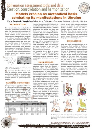
  • 1. Models erosion as methodical basis combating its manifestations in Ukraine Yuriy Dmytruk, Vasyl Cherlіnka, Yurіy Fedkovych Chernіvtsі Natіonal Unіversіty, Ukraine INTRODUCTION The water and wind erosion heading the list of destructive phenomena concerning of the soils. The emergence and development of processes of water erosion is one of the most urgent problems for the environment of Ukraine. Erosion is a leading factor in the loss of the fertile soil layer, that is, its degradation as a natural and economical resource. It is relevant even for relatively arid areas, since the storm-like nature of the precipitation implies the immediate emergence of temporary water streams, which determine the appearance of linear erosion elements. A detailed analysis carried out by soil scientists in Ukraine has shown that the combination of negative factors has a positive dynamic (Baljuk et al., 2010). а) b) Fig. 1. Geographical location of the research area within Ukraine (a), Chernivtsi region (b) The foundation of modern advances in the field of combining erosion models with geoinformation systems has already been laid, and these results are theoretical basis for the practical realization of spatial analysis and modeling. MATERIALS AND METHODS Data processing was carried out with the use of GIS GRASS (GRASS Development Team, 2017). As object of research, a fragment of the territory of Ukraine (Fig. 1a) was selected, in particular the Kitsman district of the Chernivtsi region (Fig. 1b), is confined to the Dniester-Prut watershed (Northern Bukovina) with contrasting geomorphological conditions. To create simulation models of soil cover, we used the Cherlinka script (2017c, d, b) written on the R-statistic, which includes a number of adaptations for solving set tasks and implements 14 basic types of predicative algorithms. This work used Random Forests, its implementation in the R ranger package (Wright and Ziegler, 2017). Based on the analysis of the DEM (GRASS Development Team, 2017), we simulated and evaluated the potential risks of erosion phenomena using the SIMWE model (Mitas and Mitasova, 1998; Mitasova and Mitas, 2001; Hofierka et al., 2002; Fernandes et al., 2017). The parameters of the model were chosen according to Koko data (2011). For comparing we are given by erosion modeling on the example of the typical region of Ukraine, which is average for all parameters. As we see (Figure 2a, Table 1), only 60.3% of its territory is covered by soil surveys. MAIN RESULTS To fill the gaps, we used the Random Forest algorithm, which them we obtained a predicative soil map with κ = 87.4% (Fig. 2b). This allowed us to use these predictive data for the expansion of the official assessment of the territory's erosion. If we calculate erosion only according to official data (we recall that the data are 60-30 years old), then in general it is 15862 ha or 26% of the area of the district (Fig. 2c, Table 1). If we estimate the erosivity of the soil to give a predicative soil map, then we see that the erosivity increases by 224%, with strongly eroded soils occupying almost 2 times more areas (Fig. 2d, Table 1). The area of the sedimented soils remained at the previous level. In contrast to the previous approach the definition of the number of eroded areas, the next approach is based on a mathematical model experiment. Simulation of water erosion based on SIMWE model showed interesting results. First of all, it is clearly observed that erosion processes are timed to the relief of the territory. Further simulation, allowed to obtain a complete picture of erosion hazard (Fig. 2e). This figure shows that the location of eroded soils on the official maps do not really have the necessary precision, since they do not take into account many of the moments associated with the progress of real erosion processes. CONCLUSIONS It has been shown that the existing data on the development of soil erodibility in Ukraine are outdated, incomplete and have numerous errors. An advanced version of the evaluation of this data, i.e. filling gaps in researches through predicative soil modeling, although possible, but can’t be too precise due to incomplete reliability of the source data. Our research confirms the effectiveness of using GRASS GIS and the model of water erosion-deposition SIMWE for a more correct assessment of the phenomenon of erosion. This is a prerequisite for the development of a system of anti-erosion measures at a qualitatively higher level. It also allows assessing different scenarios and strategies to combat the manifestations of erosion processes. Such an approach is scalable for the entire territory of Ukraine and may be recommended for a more accurate assessment of the risks of erosion. Tab. 1: Differences between official and model data on soil erosion Fig. 2. Soil resources of the region of research: map of agro-industrial groups of soil (a); predicative soil map (b); eroded soils according to official data (c); eroded soils according to the predicative map (d); erosion-deposition map from SIMWE, kg∙m-2∙s-1 (e) a) d) b) c) e)