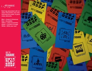
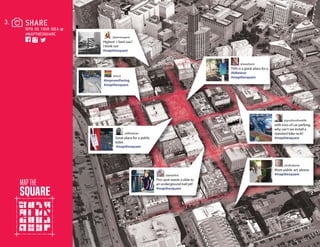
Project Name : MAP THE SQUARE
Lot Size : N/A
Building Size : N/A
Location: Pioneer Square - Seattle, Washington
Project Type : Urban Public Art Installation
Today, Seattle is the 18th most populous city in the United States and its original neighborhood, Pioneer Square has enormous
potential to become a more socially-vibrant, lively urban core. Pioneer Square is home to stark contrasts. Art galleries, boutique
restaurants, high-end housing and blossoming tech startups within historic buildings are contrasted by homelessness, devel-
opment limitations, a hub of mental health facilities and lack of urban-enhancing amenities. Many empty or under-utilized prop-
erties await the development of future change, and the Map the Square team sought to influence this design change by inviting
the public voice.
Map the Square is a physical art installation and digital interactive urban mapping project that elevates public conversation
around design and the built environment in Pioneer Square.
The week-long physical installation coincided with the Seattle Design Festival’s block party in Occidental Square, the heart of
the neighborhood. In response to the festival’s theme, “Design Change,” the Map the Square team asked:
1.	 How can we help the public and local stakeholders articulate the problems in the urban built environment in this neigh-
borhood?
2.	 Is it possible for our installation to allow the public to voice their solutions to those problems?
3.	 How can we strengthen the voice of the inhabitants, businesses, tourists, and caretakers of Pioneer Square in the dis-
cussion and 		 development of their neighborhood?
4.	 What design elements will transform Pioneer Square into a more vibrant, socially sustainable urban environment?
In partnership with the local business improvement association and local businesses, eight Map the Square kiosks were dis-
played in front of neighborhood storefronts. The playful and approachable kiosks empowered the public to stop, look and
interact with the colored tag elements and the neighborhood, asking the public to show us where they felt a change could take
place.
Participation was encouraged in the built environment and through social media using #mapthesquare, introducing a digital
and networked conversation around the exercise. The design team recorded tag locations and written input, and tracked the
feedback on an online map, now a permanent record for the public, business owners, and city officials to use as a guideline for
future development.
The project’s home base, in a local gallery, showcased the project and provided a space to gather and discuss the neighbor-
hood’s future.
This investigation crafts a template for the public to have a voice spatially that can be heard and taken into action in many other
urban spaces.
DIGITAL MAPPING
An online digital map serves
as an overall visualization
for public integration.
Kiosks
Simple, readily available
materials and spray paint
graphics made up (8) easily
moved kiosks with tags and
instructions.
Each tag associated with an
urban intervention and color
informing the public of good
urban elements.
Blue = Acess & Entrances
Red = Sociability
Yellow = Uses & Activities
Green = Comfort & Image
White = Write your own
People were encouraged
to take photos of the loca-
tions they would like to see
changed with their chosen
tag.
People were encouraged
to take photos of the loca-
tions they would like to see
changed with their chosen
tag.
Park(ing) Day
The kiosks were installed at
three additional locations
for International Parking
Day.
A-Gallery
At the end of a two month
install, this information will
also be transposed onto the
online map.
Phase I. Public Art Installation and Data Collection
•	 8 Kiosks
•	 Over 200 tags tied
•	 2 Gallery Receptions
•	 3 Park(ing) Day stalls
•	 Social media presence: Instagram, Facebook and Twitter
•	 Countless conversations, questions and community interactions 	
	 around improving the built environment in Pioneer Square
Phase II. Data Analysis + Strategic Plan Integration
The Map the Square team continues to gather and analyze the public’s
feedback. The resulting data will help build a series of maps that will high-
light hot spots, patterns and commonalities. These maps will be folded into
the local business improvement association’s strategic plans as guidelines
for future development.

MapTheSquare

  • 1.
    Project Name :MAP THE SQUARE Lot Size : N/A Building Size : N/A Location: Pioneer Square - Seattle, Washington Project Type : Urban Public Art Installation
  • 2.
    Today, Seattle isthe 18th most populous city in the United States and its original neighborhood, Pioneer Square has enormous potential to become a more socially-vibrant, lively urban core. Pioneer Square is home to stark contrasts. Art galleries, boutique restaurants, high-end housing and blossoming tech startups within historic buildings are contrasted by homelessness, devel- opment limitations, a hub of mental health facilities and lack of urban-enhancing amenities. Many empty or under-utilized prop- erties await the development of future change, and the Map the Square team sought to influence this design change by inviting the public voice. Map the Square is a physical art installation and digital interactive urban mapping project that elevates public conversation around design and the built environment in Pioneer Square. The week-long physical installation coincided with the Seattle Design Festival’s block party in Occidental Square, the heart of the neighborhood. In response to the festival’s theme, “Design Change,” the Map the Square team asked: 1. How can we help the public and local stakeholders articulate the problems in the urban built environment in this neigh- borhood? 2. Is it possible for our installation to allow the public to voice their solutions to those problems? 3. How can we strengthen the voice of the inhabitants, businesses, tourists, and caretakers of Pioneer Square in the dis- cussion and development of their neighborhood? 4. What design elements will transform Pioneer Square into a more vibrant, socially sustainable urban environment? In partnership with the local business improvement association and local businesses, eight Map the Square kiosks were dis- played in front of neighborhood storefronts. The playful and approachable kiosks empowered the public to stop, look and interact with the colored tag elements and the neighborhood, asking the public to show us where they felt a change could take place. Participation was encouraged in the built environment and through social media using #mapthesquare, introducing a digital and networked conversation around the exercise. The design team recorded tag locations and written input, and tracked the feedback on an online map, now a permanent record for the public, business owners, and city officials to use as a guideline for future development. The project’s home base, in a local gallery, showcased the project and provided a space to gather and discuss the neighbor- hood’s future. This investigation crafts a template for the public to have a voice spatially that can be heard and taken into action in many other urban spaces.
  • 3.
    DIGITAL MAPPING An onlinedigital map serves as an overall visualization for public integration.
  • 4.
    Kiosks Simple, readily available materialsand spray paint graphics made up (8) easily moved kiosks with tags and instructions.
  • 5.
    Each tag associatedwith an urban intervention and color informing the public of good urban elements. Blue = Acess & Entrances Red = Sociability Yellow = Uses & Activities Green = Comfort & Image White = Write your own
  • 6.
    People were encouraged totake photos of the loca- tions they would like to see changed with their chosen tag.
  • 7.
    People were encouraged totake photos of the loca- tions they would like to see changed with their chosen tag.
  • 9.
    Park(ing) Day The kioskswere installed at three additional locations for International Parking Day.
  • 10.
    A-Gallery At the endof a two month install, this information will also be transposed onto the online map.
  • 14.
    Phase I. PublicArt Installation and Data Collection • 8 Kiosks • Over 200 tags tied • 2 Gallery Receptions • 3 Park(ing) Day stalls • Social media presence: Instagram, Facebook and Twitter • Countless conversations, questions and community interactions around improving the built environment in Pioneer Square
  • 15.
    Phase II. DataAnalysis + Strategic Plan Integration The Map the Square team continues to gather and analyze the public’s feedback. The resulting data will help build a series of maps that will high- light hot spots, patterns and commonalities. These maps will be folded into the local business improvement association’s strategic plans as guidelines for future development.