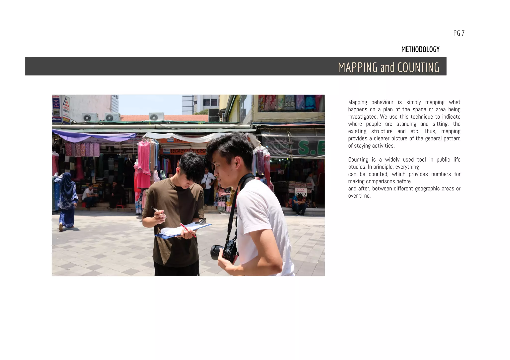
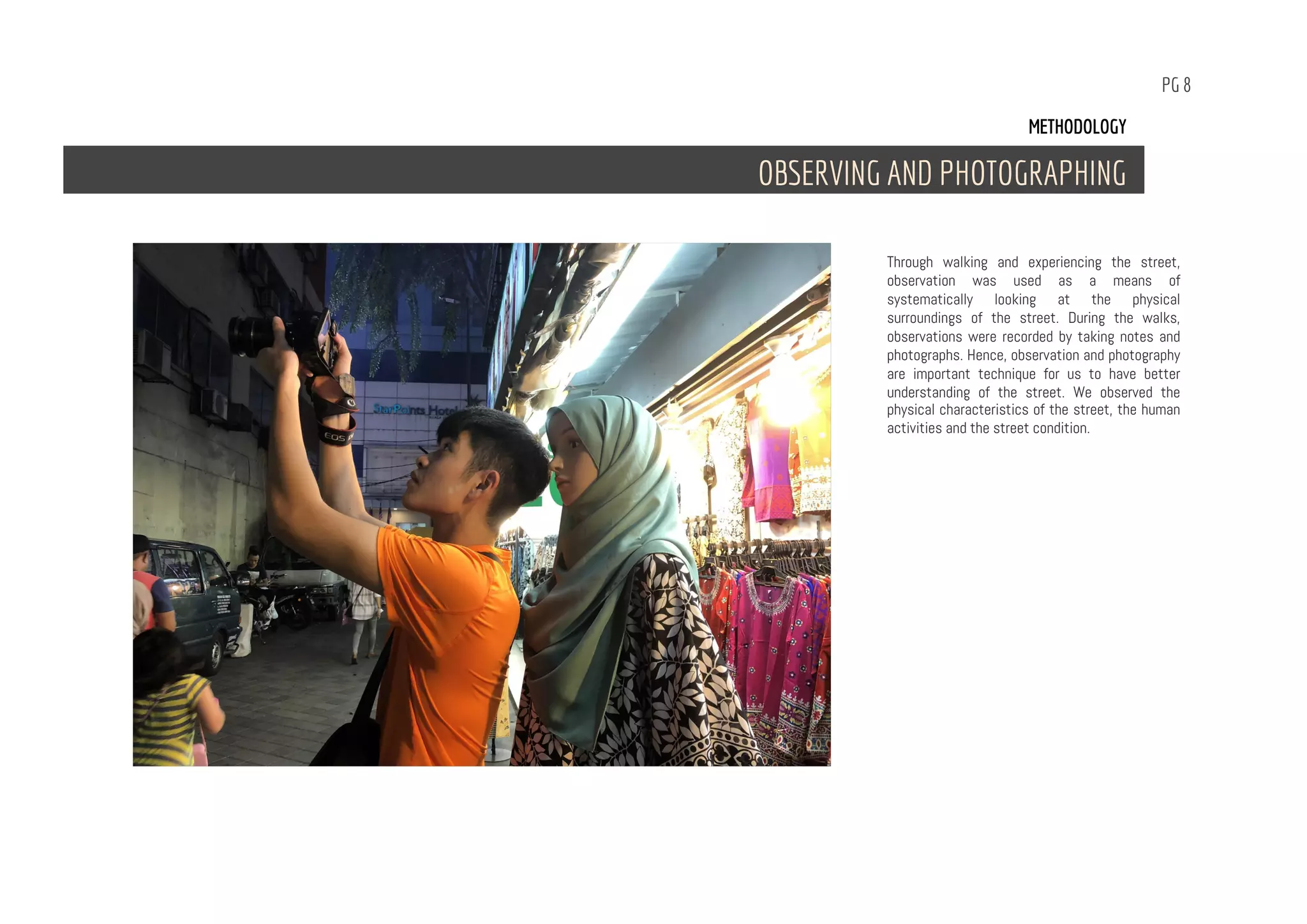
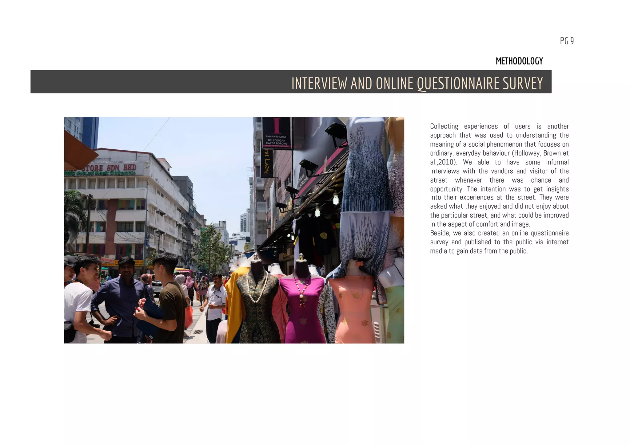
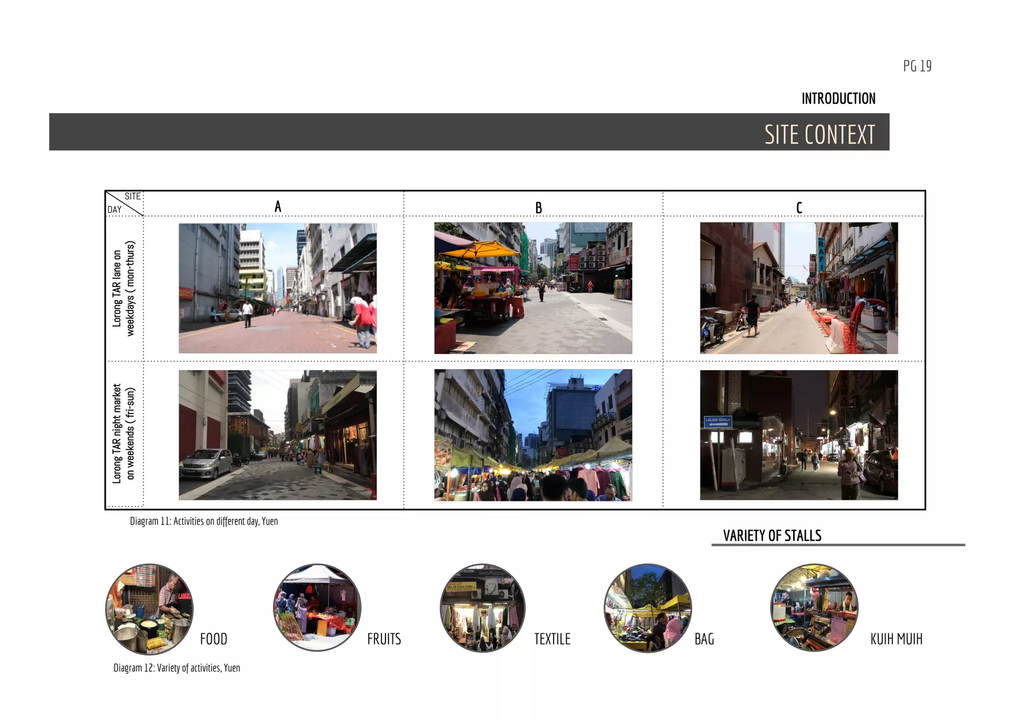
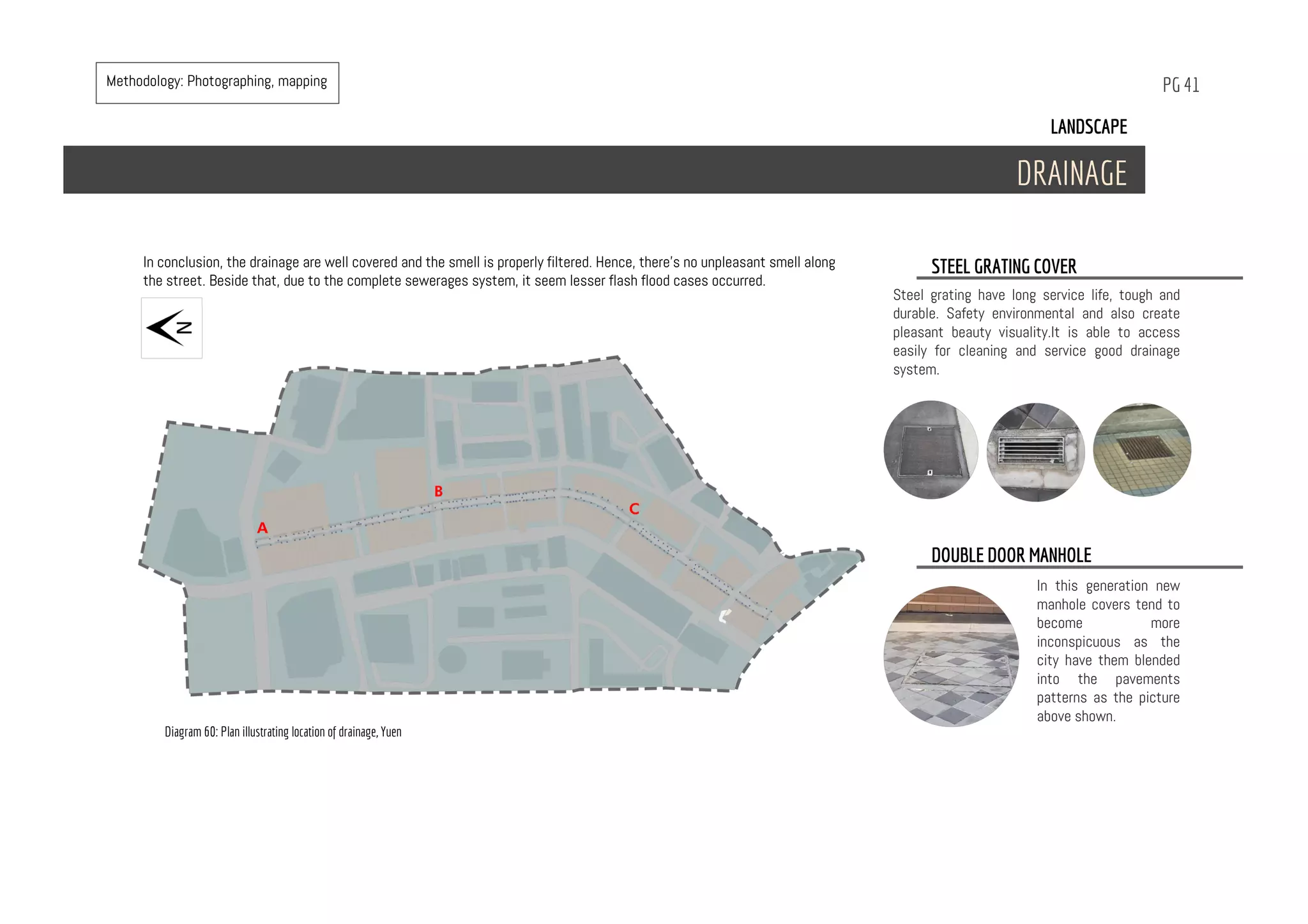
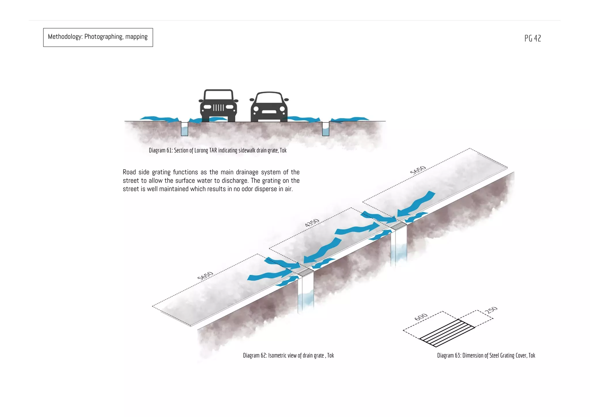
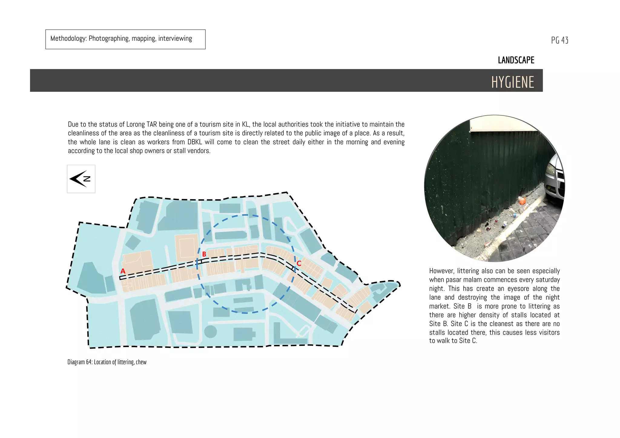
PREPARED BY:
Chew Rui Bo 032234
Chee Jia Xin 0327392
Jordan Tok Wen Xuan 0327629
Yuen Xuan Hui 0324292
Alexandra 1003A78541
Comfort & image
CONTENTS
01 LITERATURE REVIEW
A. The concept of public space
B. Placemaking
02 METHODOLOGY
A. Visiting Temporary Market
B. Walking
C. Mapping
D. Observing and photographing
E. Interview and online questionnaire survey
03 INTRODUCTION
A. History and morphology
B. District
C. Landmark
D. Site context
04 VIEW AND VISTAS
A. Serial vision
05 CLIMATE
A. Average temperature
B. Average precipitation
C. Sunpath
D. Wind
06 BUILT FORM
A. Building condition
07 LANDSCAPE
A. Hardscape
B. Softscape
C. Drainage
D. Hygiene
08 CIRCULATION
A. Public transport
B. Vehicle
C. Pedestrian
09 SOCIAL
A. Demographic
B. Social issue
C. Nodes
10 SYNTHESIS
11 REFERENCES
LITERATURE REVIEW
THE CONCEPT OF PUBLIC SPACE
PLACE-MAKING
01
PG 1
PG 2
Jane Jacobs (1961) and Jan Gehl (1987) assert a idea about the city and the street functioning as social and communal spaced for its people. In The Death and Life of Great
American Cities, Jacob writes, “if a city’s streets look interesting, the city looks interesting ; if they look dull, the city looks dull” (p. 273). What Jacobs is mentioning to is not
the design appearance of the street, but rather a street with activities generated by people. Gehl calls it ‘life between buildings’, which includes all of the vary different activities
people engage in when they use common city space for walking, meeting, talking to others, shopping and other pursuits.
Temporary markets redefine public spaces in the Asian context because of their spatial complexity is different from the Western notion of order (Edensor, 1998). The temporary
markets contribute to the city’s street life because most temporary markets operate outdoors. Markets become a type of place where people can engage in shopping and leisure
activities. Although there are also temporary market held indoors, the activities conducted at markets, like walking, buying and socializing are not much different from the
activities described by Jacobs and Gehl. However, temporary markets have specific ways of operating and offer a distinctive experience that make them different to other typed
of public space.
Temporary markets commonly serve as places where goods are traded, while at the same time acting as a public or communal space (Tangires, 2008). They operate by borrowing
existing public space such as the street, sidewalk and other vacant space in towns and cities.
THE CONCEPT OF PUBLIC SPACE
PG 3
Placemaking is a multifaceted approach to planning
and managing public spaces. Placemaking inspires
people to collectively reimagine and reinvent public
spaces as the heart of every community. We can
shape our public realm in order to maximize shared
value by strengthening the connection between
people and the place they share. Not only promoting
a better urban design, placemaking also facilitates
creative patterns of use, paying particular attention
to the physical, cultural, and social identities that
define a place and support its ongoing evolution.
The vision of Project for Public Space (PPS) is
“Building community, creating places, using
common sense”. According to PPS finds, a
successful place must have 4 key attributes which
is accessible, people engage in activities, comfort
and sociable place for people to interact. The place
diagram is one of the tools PPS has developed to
help communities evaluate places. The inner ring
represents a place’s key attributes, the middle ring
its intangible qualities, and the outer ring its
measurable data. In this report, we will look into
comfort & image.
PLACE MAKING
METHODOLOGY
VISITING TEMPORARY MARKETS
WALKING
MAPPING
OBSERVING AND PHOTOGRAPHING
INTERVIEW AND ONLINE QUESTIONNAIRE SURVEY
02
PG 4
PG 5
Before our analysis, we conducted our site visit
to the night market at Lorong TAR in order to
undertake an inventory of the site. The physical
features that are visible such as surrounding
buildings,the condition of the buildings,
circulation, landscape characters, vegetation
and site condition that are visible are
documented by us. Through visiting the market,
we experience the street by ourselves and feel
the qualities and characteristics that the market
may have.
Hence, in this study we employed walking,
observing and photographing as methods of
experiencing and study the qualities of the
markets. Beside, we also did interview with the
local regard to our studies.
METHODOLOGY
VISITING TEMPORARY MARKET
PG 6
Walking - an ordinary activity that used by people
to navigate through the space. It is temporal,
and it allows people study and experience the
space around them. As our site is Lorong TAR
where it held night market every Saturday,
walking become our main medium to experience
for visiting the markets. We can experience and
sense the qualities of the market by walking
through it.
METHODOLOGY
WALKING
PG 7
Mapping behaviour is simply mapping what
happens on a plan of the space or area being
investigated. We use this technique to indicate
where people are standing and sitting, the
existing structure and etc. Thus, mapping
provides a clearer picture of the general pattern
of staying activities.
Counting is a widely used tool in public life
studies. In principle, everything
can be counted, which provides numbers for
making comparisons before
and after, between different geographic areas or
over time.
METHODOLOGY
MAPPING and COUNTING
PG 8
Through walking and experiencing the street,
observation was used as a means of
systematically looking at the physical
surroundings of the street. During the walks,
observations were recorded by taking notes and
photographs. Hence, observation and photography
are important technique for us to have better
understanding of the street. We observed the
physical characteristics of the street, the human
activities and the street condition.
METHODOLOGY
OBSERVING AND PHOTOGRAPHING
PG 9
Collecting experiences of users is another
approach that was used to understanding the
meaning of a social phenomenon that focuses on
ordinary, everyday behaviour (Holloway, Brown et
al.,2010). We able to have some informal
interviews with the vendors and visitor of the
street whenever there was chance and
opportunity. The intention was to get insights
into their experiences at the street. They were
asked what they enjoyed and did not enjoy about
the particular street, and what could be improved
in the aspect of comfort and image.
Beside, we also created an online questionnaire
survey and published to the public via internet
media to gain data from the public.
METHODOLOGY
INTERVIEW AND ONLINE QUESTIONNAIRE SURVEY
PG 10
RESULTS AND DISCUSSION
Response format : 1= Very Poor, 2= Poor, 3=Satisfactory, 4=Good, 5=Very Good
Table 1: Physical conditions findings for shopping streets
METHODOLOGY
RESULTS AND DISCUSSION
Intangible attributes Components Results
Access and Linkage & Walkability Condition of mixed used pathway Satisfactory
Pathway clearly defined Good
Sufficient space to walk Very good
Space is suitable for public performance (i.e. :flash mobs) GoodUses and activity: Uniqueness
Businesses are diversified Satisfactory
Space is favourable for celebrations Good
Sociability: Diversity
Sufficient trees plantedComfort and images: (Green) Strongly disagree
Existing trees provide shading Disagree
Buildings are old and affecting comfortability(Attractive)
(Sittable)
Neutral
Night market food and products Strongly agree
Sufficient sitting area Strongly disagree
PG 11
Response format : 1= Very Poor, 2= Poor, 3=Satisfactory, 4=Good, 5=Very Good
Intangible attributes Components Results
(Safe) Feeling safe while walking on the street Neutral
Feeling threatened by incoming vehicles Agree
Pleasant walk Neutral
Continue walking despite weather Neutral
Welcoming feeling visiting the street out out of
night market period
AgreeUses and Activity: Uniqueness
Allows social interaction (taking pictures around)Sociability: (diversity) Neutral
Chit chatting Agress
Any rubbish on the pathwayComfort and images: (Cleanliness) Neutral
Access and linkage: (Walkability)
Table 2: Users experience findings on shopping streets
INTRODUCTION
HISTORY
DISTRICT
LANDMARK
SITE CONTEXT
03
PG 12
The arrangement of small town settles during the 1895’s were of a natural formation, configured to confluence, it hug the path of the Klang and
Gombak Rivers and eventually forming a ‘linear configuration’.
Made up of the Chinese, Malay & British communities, each race found reason to settle in the country for trade, business and politics. This
eventually led to the establishment of a transportation network that linked the people to the various tin mines, administrative capitals and trading
ports.
Tuanku Abdul Rahman (TAR) is a traditional shopping district in Kuala Lumpur. It lies just north of the City Centre and is named after its
main artery, Jalan Tuanku Abdul Rahman, which is often abbreviated to Jalan TAR.
The street was known as Batu Road, it started as a track that leads to Batu Village, Limestone Caves and tins mines. It was renamed jalan
Tuanku Abdul Rahman, after first Yang di-Pertuan Agong of Malaysia. It was the main street in Kuala Lumpur at one time, also the city's
longest road with shops set up in prewar buildings along both sides. These buildings reflect changing trends in architectural design over
decades.
Most of the pre war buildings, with their antique architectural features, still exist and are preserved though some have been torn down to
give way to modern multi storey buildings.
The neighbourhood flourished and in the early 1980s, Jalan TAR was turned into a one way street to ease traffic flow. According to the
Vendor Association of Lorong TAR, the market initially operated on the main road, which is Jalan TAR, and not on the current backlane. Due to
the traffic congestion that it had caused every Saturday night, the city council decided to relocate the market to the back lane. After the
relocation, it took vendors more than five years to reactivate the night market as it once was, as people were not familiar with its new
location which was not as visible as it was on the main road. However, the market was supported by the similar infrastructures that the
previous location had, vendors persisted and eventually visitors started to come back to visit the market over time. Every Saturday, between
5 to 10 pm, the Lorong Tuanku Abdul Rahman is closed to vehicles to make room for a night market that offers an assortment of fabrics,
textiles, clothing and food at affordable prices.
INTRODUCTION
HISTORY AND MORPHOLOGY
Diagram 1: Key plan, Tok.
PG 13
MORPHOLOGY
1895
HISTORY
Diagram 2: Key plan (1895), Yuen
PG 14
1962
The boom of technology and economies in Malaysia in the 60’s, modern architecture saw to the flourish in the rise of modernization .Many
high rise shopping complexes, such as Pertama Complex, Campbell Complex and the Ocean Cinema are built to introduce new form of social
activities. The increase in wealth and media allowed development to occur rapidly, attracting tourists and seeing a rise to the attendance in
social establishments.
1939
As growth of the village continued, there was a need for expansion and primary urban planning to accommodate the needs of the people.
Shophouses were introduced by the Chinese community, serving 2 functions- as both homes and shops. Various streets lined with these
shop houses became marketplaces of trade, where goods were exchanged as an act of symbiotic living. In time, the development overtook
the village turning the swamps, rice fields and coconut estates in the area into one of the busiest road in Kuala Lumpur. Many of these
shop houses still boast features of British Colonial Architecture, reflecting the image of the city during its time.
Diagram 3: Key plan (1939), Yuen
Diagram 4: Key plan (1962), Yuen
PG 15
2017
Over two decades, the development of Kuala Lumpur growing exponentially, seeing to many advances in the urban fabric with the help of
technology. High rise buildings and modern architectural structures are scattered over the district, diffusing the concentration of tourists
and business in Jalan Tunku Abdul Rahman and many other hotspots, uninhabitable buildings were demolished or renovated with new
modern implementations, erasing mark of the past era.
Now, in the year of 2017, it has become a relatively quiet area, except for the Hari Raya and Deepavali festivals. In comparison with decades
ago, the trade market, which does not see to the same crowd as before, is lacking the mix of the Malay, Chinese and Indian community, and
foreign immigrants have overtaken most of the business in Jalan TAR entirely, it is plausible due to the affordable cost of living in the
surrounding area.
1989
Consequently, to the evolution of the city’s development, more shopping complexes were built, such as Sogo Shopping Mall- which replaced
the Sulaiman Court- and Maju Junction Mall. Cultural landmarks like Masjid Jamek also followed in suit. With the city catering for more
people than ever, traffic congestion along popular roads and shopping streets became near unbearable, Jalan Tunku Abdul Rahman then
became a one-way street, easing the flow of traffic, but possibly costing the popularity of shops to drop due to the fast- moving crowd.
Every Saturday night, a pasar malam (night market) from the junction near Sogo to jalan tun Perak drew huge crowds until early 1990.
Diagram 5: Key plan (1989), Yuen
Diagram 6: Key plan (2017), Yuen
INTRODUCTION
DISTRICT
According to Kevin Lynch, districts are the areas within a large city that share the common character. Determining
districts by function plays an important role in giving identity to the district. Lorong Tuanku Abdul Rahman has a very
distinctive character where it’s recognized as a textile district.
Lorong TAR is the only night market that operates within a city centre. One of the reasons for its popularity is because of
its location in the heart of Kuala Lumpur’s heritage zone, which is also the location of fabric and clothing retail shops.
Commercial district
Heritage district
Corporate district
Textile district
Diagram 7: Key plan for district, Tok
Diagram 8: Aerial view indicating
different districts, Tok
PG 16
LANDMARKS
LANDMARKS
PG 17
Landmarks are external features to the
individual that acts as reference points.
The site has 3 levels of landmark, assisting
users from different hierarchy levels in
navigating the area. Urban level landmark
allow users of higher hierarchy levels in
navigating the area.
Urban level landmarks allow users of higher
hierarchy to identify the area; street level
landmarks help users in adjacent streets
navigate into the area; local level
landmarks are used by locals familiar with
the area in navigation.
Varying levels of landmarks in varying
hierarchy levels of districts will have an
impact on the districts themselves,
making a district more distinguishable than
visual.
MENARA UOB
CIMB BANK
BERHAD
UDA HOLDINGS
BERHAD
SOGO
MASJID INDIA
WISMA BANDAR
KAMDAR
JOYALUK-
KAS KL
Diagram 9: Location of landmark, Yuen
Methodology: Photographing, mapping
PG 18
Lorong TAR which is an alley behind Jalan TAR engages pedestrians in a more intimate scale, especially when the night market is in action. It is 745m in length. Double frontages
of shop lots creates permeability between the adjacent streets, further strengthening the interaction within the site. Tents along the alley creates an enclosure, maintaining
interaction among users at ground level. The lane is being divided into 3 parts, site A, B, C according to the activities happening on the street.
INTRODUCTION
SITE CONTEXT
Diagram 10: site plan indicating views direction of section, Chee
PG 19
INTRODUCTION
SITE CONTEXT
VARIETY OF STALLS
BAG KUIH MUIHFOOD FRUITS TEXTILE
LorongTARlaneon
weekdays(mon-thurs)
LorongTARnightmarket
onweekends(fri-sun)
A B CDAY
SITE
Diagram 11: Activities on different day, Yuen
Diagram 12: Variety of activities, Yuen
PG 20
Site B has approximately 8.15m width of street which
is the widest mixed use pathway than site A and C.
Both sides of the street are used by the vendors.
Furthermore,the shoplots at this site tend to have
higher building height. Thus, they provide better shading
than site A. Hence, this area has the most number of
vendors compared to site A and C.
SITE BSITE A
Based on our observation, most of the vendors gather
at the left side of the street as there is some empty
spaces available and the shoplots are located along
the right side of the street. There are lesser vendors
here compared to site B.
SITE C
Site C is more to residential area as most of the buildings
at the left side are apartment. While the shoplots in this
area are mostly restaurant. Hence, there are many cars
parked at the front of the shoplots. There is very little
vendors can be found here.
Shopping mall Shoplots Shoplots Shoplots Shoplots Shoplots
Apartment
parking lot parking lot parking lot parking lot parking lot parking lotmixed
use
pathway
mixed use
pathway
mixed
use
pathway
Diagram 13: Section of Site A, Yuen Diagram 14: Section of Site B, Yuen Diagram 15: Section of Site C, Yuen
VIEWS AND VISTAS
Serial vision
04
PG 21
Views and vistas
SERIAL VISION ( site A )
PG 22
1.
3.
5.
2.
4.
6.
Diagram 16: Location of site A
Diagram 17: Entry point view, Chew
Diagram 19: Car park area, Chew
Diagram 21: Motor parking area, Chew
Diagram 18: Extended function from shops, Chew
Diagram 20: Planter box in front of shophouses, Chew
Diagram 22: Potential sitting area, Chew
Methodology: Photographing, mapping
Views and vistas
SERIAL VISION ( site B )
PG 23
1.
3.
5.
2.
4.
6.
Diagram 24: Traffic movement at junction, Chew
Diagram 26: Wider pavement, Chew
Diagram 28: Huge canopy of trees providing shading, Chew
Diagram 25: 2- way circulation for vehicles, Chew
Diagram 27: Food truck and stall beside, Chew
Diagram 29: Sense of chaotic, Chew
Diagram 23: Location of site B
Methodology: Photographing, mapping
Views and vistas
SERIAL VISION ( site C )
PG 24
1.
3.
5.
2.
4.
6.
Diagram 31:Apartment buildings, Chew
Diagram 33: Car parking, Chew
Diagram 35: Side alley view from site c, Chew
Diagram 32: Pedestrian movement can be seen, Chew
Diagram 34: Narrow road creates sense of enclosure, Chew
Diagram 36: Towards Masjid India, Chew
Diagram 30: Location of site C
Methodology: Photographing, mapping
CLIMATE
AVERAGE TEMPERATURE
AVERAGE PRECIPITATION
SUNPATH
WIND
05
PG 25
INTRODUCTION
ENVIRONMENTAL DATA ( MACRO)
PG 26
The highest temperature in Chow Kit rises
up to 33℃. Its maximum temperature of an
average day in each month remained
stationary from February to September,
with an average temperature of 30℃.
During the rainy season (October -
December), the temperature decrease by 1
to 2℃.
AVERAGE TEMPERATURE
In the morning and evening, the lane is
comfortable to walk as the temperature of
the air is comfortable, however, without
proper shading, during noon till afternoon (
12pm - 2pm) visitors will feel
uncomfortable as it is too hot.
AVERAGE PRECIPITATION
The rainy season is during October -
December.
During this period the night market might
be affected as there are no shading when it
rains. The shoplots at the site will serve as
a shelter for the visitors when it rains.
Diagram 37: Average temperature, Metreoblue KL
Methodology: Research, interview
INTRODUCTION
ENVIRONMENTAL DATA ( MICRO)
PG 27
SUN PATH
Diagram 39: Sun Path at 10am, Revit
Diagram 38: Sun Path at 8am, Revit
SITE A SITE B SITE C ANALYSIS
This is the period where the
site receive the most shade
from the nearby buildings at its
east. Almost the whole site is
being shaded.
Pedestrians feel comfortable
walking on any part of the lane
as it is completely shaded from
sunlight.
Site B and C is fully shaded by
the nearby buildings at its
east. However, for Site A, part
of the lane is not shaded.
Pedestrians walking along Site
A might feel slightly discomfort
while walking along the lane on
the west side
Methodology: Research, mapping, interview
The lane receive the some
shade from the buildings at its
west.
Pedestrians walking along the
street at the east side of the
lane or shoplots will feel
uncomfortable.
PG 28
SITE A SITE B SITE C ANALYSIS
Diagram 40: Sun Path at 12 noon, Revit
Diagram 41: Sun Path at 2pm, Revit
The sun is almost directly above
the lane. The whole lane is
experiencing direct sunlight
exposure.
Pedestrians feel extremely
uncomfortable walking along the
lane as there are no shading
devices provided. During this time,
less visitors visit site. It only
serve as a lane to passby.
Methodology: Research, mapping, interview
PG 29
SITE A SITE B SITE C ANALYSIS
Diagram 42: Sun Path at 4pm, Revit
Diagram 43: Sun Path at 6pm, Revit
The lane receive the some
shade from the buildings at its
west.
Pedestrians walking along the
street at the east side of the
lane or shoplots will feel
slightly uncomfortable.
The lane receive the shade
from the nearby buildings at its
west. Almost the whole lane is
being shaded.
Pedestrians feel comfortable
walking on any part of the lane
as it is completely shaded from
sunlight.
Methodology: Research, mapping, interview
PG 30
WIND
Throughout the year, the wind is the strongest from the South and Northeast.
The lane is well ventilated as there are openings in between the rows of shop lots
surrounding the site. The openings allows the air to flow in different directions.
Besides, the open air typology of the site prevents the cooking fumes and stuffiness
of air caused by the high density of people along the lane when the night market
commences to trap at the lane and allows more air flow. This makes the visitors feel
comfortable while visiting the night market.
Diagram 44: Wind rose , metreoblue kl
Diagram 45: Opening along
the lane, Yuen
Methodology: Research, mapping, interview
BUILT FORM
BUILDING CONDITIONS
06
PG 31
PG 32
BUILT FORM
BUILDING CONDITION
Few old and rusty shophouses located at the entrance of lorong TAR at site A, affecting the aesthetic value and ingress experience of the street. Some old shophouses façade
create uncomfortable feeling to the pedestrians due to the destructed building elements, structure and issues such as leaking roof and torn wire. Besides, there’s no dedicated
spaces for rubbish bin integrated in the shophouses, resulting in rubbish being placed at the side of walkway for the city’s maintenance service to clean up.
1
1 2 3
4
5
2
3
4
5
Diagram 46: Buildings with different conditions, Chew
Methodology: Photographing, mapping, interview
PG 33
New buildings with extreme height creates a distinct skyline and
injecting sense of modernism to the streetscape. The sense of
enclosure is enhanced by these high rise buildings, giving the
pedestrian a feeling of protection while walking on the street.
However, they tend to have similar looking facade and lack of
diversify architectural style. Double façade no longer appears on new
high rise buildings, ground level business might be fading.
1
2
2
1
Building in phase of construction is covered with scarf
folding creates poor visual attribute to the street.
Besides, it gives unpleasant experience and temporal
discomfort to the pedestrians such as noise and dust. 2
Diagram 47: Buildings with different conditions, Chew
Methodology: Photographing, mapping, interview
PG 34
2
Newly renovated shophouses with contrasting looking colour induced sense of vibrancy in
the midst of old looking street. Besides, the signage of the shophouses are more distinct
and eye-catching in the design in terms of colour use and shapes as compared to the old
ones. This in turns attracting younger visitors into the shop.
1
1
As Lorong TAR is located at the back lane of
shophouses, it’s exposed to the abundance of air
conditioning outdoor unit which reduces the visual
quality of the street. High rise buildings lack of shading
devices or might be insufficient
2
2
Diagram 48: Buildings with different conditions, Chew
Methodology: Photographing, mapping, interview
LANDSCAPE
HARDSCAPE
SOFTSCAPE
DRAINAGE
HYGIENE
07
PG 35
LANDSCAPE
HARDSCAPE
PG 36
Diagram 49: Site plan for hardscape, Yuen
Methodology: Photographing, mapping
PG 37
Signage systems are used normally at
junctions to provide information of
wayfinding to the night market and also
the carparks, thereby assisting in
navigation for the circulation of
pedestrians and vehicles
SIGNAGEBRICK PEDESTRIAN
WALKWAY PAVEMENT
Good condition and clean brick
pedestrian walkway pavement
increases the walkability of lorong Tar
PLANTER BOX
The planter boxes being placed at the
side of the walkways did not create
congestion or block pedestrian traffic.
Besides that it also does not obstruct
and views of the pedestrians. The edges
of raised planters can provide informal
seating. Besides that it can help buffer
trees and plants from damage when
there is high density of people walking
along the street.
STREETLIGHT
None of the streetlights along the street
were utilised as most of them were
broken, During weekdays ( from monday
the thursday) , at night the whole street
is dark there are no streetlights.
However, during weekends ( friday-
sunday when night market commences
Site A- B is well lit there are lighting
from the stalls. However, Site C is dark
as there are less stalls.
Diagram 50 Diagram 51 Diagram 52 Diagram 53
Methodology: Photographing, mapping, interviewing
PG 38
JERSEY BARRIERTNB METER PANEL DRAINAGE COVER FIRE HOSE SYSTEMS
Jersey barriers which are initially used to minimize
vehicle damage in cases of incidental contact of
the buildings while still preventing vehicle
crossovers resulting in a likely head-on collision
during construction which happened few month ago
Fire hose systems are being
installed at the facade of the shop
lots facing the street to provide
fire protection for the street.
However, it is not properly
maintained and was misused as a
spot to throw rubbish.
Proper drainage cover not only
provides proper coverage for the
drains but also prevents bigger
objects to be flushed in the drain,
preventing the drain from being
clogged. Besides it allow the
streets to be safer and more
walkable as it prevents
pedestrians from falling in the the
drains.
Most of the TNB metal panels on the
site are not properly maintained.
For panels
which are
not in good
condition,
some of the
covering of
the panels
are not
locked, rusted and also misused as
pedestrians will throw rubbish in or on
the panels
at the site was found
dispersed throughout the
site. The jersey barriers
which were used during the
construction were not kept,
instead dispersed on the
street causing obstruction
Diagram 54 Diagram 55 Diagram 56 Diagram 57
Hardscape on site should be regularly maintained and also complete so that they could comfortable, safety and clean environment for users along the lane.
Methodology: Photographing, mapping, interviewing
LANDSCAPE
SOFTSCAPE
PG 39
Diagram 58: Location of softscape, Chew
Methodology: Photographing, mapping
LANDSCAPE
SOFTSCAPE
PG 40
There is a lack of trees throughout the lane, especially site A and C. Most of the trees are located at site B.
Advantages of trees on site:
1) Trees improve air quality
2) Block sunlight
3) Avoid cars parking up on the sidewalk
4) Soften the view of abundant hardscape, providing a more
pleasant environment to walk
However, due to the less amount of trees on site, the trees are
mainly for aesthetic purposes. As during noon, the lane is
scorching hot, the trees does not help to cool down the
temperature nor provide shelter to the visitors. Therefore, the
different amount of trees on Site A, B and C did not give any
significant impact to the site in improving the comfortability.
Disadvantages of trees on site:
1) Insufficient room for big tree at Site B to develop and grow.
- Tree roots damaging the floor tiles making the pathway less walkable and dangerous
- The overhead wires hanging on the branches of the tree
2) Huge amount of birds staying on the big canopy of the tree causing the area around to be dirty,
making the area unhygienic especially towards stalls selling food.
The big tree at Site B has caused visitors to feel uncomfortable in terms of visual perception, safety,
walkability and cleanliness. Although during noon when the lane is scorching hot, the trees is able to provide
good shading from sunlight, however, its negative effect has greatly overwhelm its positive effects as due
to unhygienic considerations pedestrians will not prefer to use the tree to shelter them from sunlight. It
creates an eyesore on Site B.
Big tree
at Site B
Small trees in
planter box
Tree width:
1.2 - 1.5 m
Tree width:
Approximately
30 m
Diagram 59: Plan indicating location of small and big tree, Tok
Methodology: Photographing, mapping, interviewing
In this generation new
manhole covers tend to
become more
inconspicuous as the
city have them blended
into the pavements
patterns as the picture
above shown.
LANDSCAPE
DRAINAGE
PG 41
In conclusion, the drainage are well covered and the smell is properly filtered. Hence, there’s no unpleasant smell along
the street. Beside that, due to the complete sewerages system, it seem lesser flash flood cases occurred.
Diagram 60: Plan illustrating location of drainage, Yuen
Steel grating have long service life, tough and
durable. Safety environmental and also create
pleasant beauty visuality.It is able to access
easily for cleaning and service good drainage
system.
STEEL GRATING COVER
DOUBLE DOOR MANHOLE
Methodology: Photographing, mapping
Road side grating functions as the main drainage system of the
street to allow the surface water to discharge. The grating on the
street is well maintained which results in no odor disperse in air.
Diagram 61: Section of Lorong TAR indicating sidewalk drain grate, Tok
Diagram 62: Isometric view of drain grate , Tok Diagram 63: Dimension of Steel Grating Cover, Tok
PG 42Methodology: Photographing, mapping
LANDSCAPE
HYGIENE
Diagram 64: Location of littering, chew
PG 43
However, littering also can be seen especially
when pasar malam commences every saturday
night. This has create an eyesore along the
lane and destroying the image of the night
market. Site B is more prone to littering as
there are higher density of stalls located at
Site B. Site C is the cleanest as there are no
stalls located there, this causes less visitors
to walk to Site C.
Due to the status of Lorong TAR being one of a tourism site in KL, the local authorities took the initiative to maintain the
cleanliness of the area as the cleanliness of a tourism site is directly related to the public image of a place. As a result,
the whole lane is clean as workers from DBKL will come to clean the street daily either in the morning and evening
according to the local shop owners or stall vendors.
Methodology: Photographing, mapping, interviewing
Proper trash collecting point should be provided to minimise littering, maintaining the image of the lane.
The main reason people litter is because there are no proper rubbish bin for visitors to throw food waste and also product packaging. Nevertheless, some informal litter bins has
been provided by only a small group of shop owners and stall .
Shop owners using stools as a rubbish
bin, placing in front of their shoplots to
prevent visitors from the night market
littering in front of their shops. However
without proper coverings this will
attract pests to come.
Shop owners using big plastic bags
for visitors to litter however, this
has created an eyesore to visitors
on the lane. The use of improper
littering bins also cause the litter
to disperse around the disposal site
when pests scratch the plastic
trash bags and cardboard box to
find food.
Stall vendor provide customers plastic
bag at their stall tent to drop their litter
and also to reduce littering around their
stall.
Fire hose installed which is meant for
fire protection during emergencies were
also used to hang rubbish.
Diagram 65: rubbish bin , Tok Diagram 66: rubbish bags on pathway, Tok Diagram 67: rubbish bag hang on tent, Tok Diagram 68: rubbish hang on fire hose, Tok
PG 44Methodology: Photographing, mapping, interviewing
CIRCULATION
PUBLIC TRANSPORT
VEHICLE
PEDESTRIAN
08
PG 45
CIRCULATION
PUBLIC TRANSPORT
PG 46
Located at a street at the north of the city centre, the site is a strategic location as it is highly accessible as visitors can use public transport as their means of transportation
to reach the site. Along Jalan Tun Abdul Rahman there are 4 bus stops while along Jalan Bunus 6 there are 2 bus stops. Beside that, there is also a lrt station ( LRT Station
Bandaraya) by rapid KL.
Jalan Tun Abdul Rahman
JalanBunus6
Lorong Tunku Abdul Rahman
Lorong Gombak
Jalan Masjid India
LorongBunus3
JalanMunshiAbdullah
Jalan Melayu
Diagram 69: Types of public transportation and route, Yuen
Methodology: Photographing, mapping
PG 47
CIRCULATION
VEHICLE LANE
Lorong TAR is highly accessible by vehicles as it is surrounded by several major roads. This has caused the site to be highly visible, attracting more visitors to visit the site.
However, there is always heavy traffic especially in the morning, during lunch hours and after office hours in the weekdays and in the evening during weekends when pasar malam
commences.
Lorong Tunku Abdul Rahman
Jalan Tunku Abdul Rahman
Lorong Gombak
JalanDangWangi
Jalan Masjid India
LorongBunus3
JalanMunshiAbdullah
Jalan Melayu
JalanBunus6
Site A and B
Site C
Diagram 70: Types of public transportation and route, Yuen
Methodology: Photographing, mapping
PG 48
Peak hours ( weekdays )
0730-0930, 1130-1330, 1700-2000
INTENSITY OF TRAFFIC
Peak hours ( weekends when night
market commences )
1700-2100
Non Peak hours
Diagram 71: Intensity of traffic on weekdays, YUen Diagram 72: Intensity of traffic during night market, Yuen Diagram 73: Intensity of traffic during non peak hours, Yuen
Methodology: Photographing, mapping, interviewing
PG 49
Jalan Dang Wangi is a major road in Kuala Lumpur. It runs east- west intersecting beginning at Jalan Raja Laut in the west, and ending
at Jalan Ampang in the east. Along the way, it intersects with Jalan Tuanku Abdul Rahman, Jalan Munshi Abdullah and Jalan Raja
Abdullah. During peak hours, this road is the reason why the area is experiencing heavy traffic as it is a major road.
Lorong Tunku Abdul Rahman
Jalan Tunku Abdul Rahman
Lorong Gombak
JalanDangWangi
Jalan Masjid India
LorongBunus3
JalanMunshiAbdullah
JalanMelayu
JalanBunus6
INTERSECTION AT MAJOR ROADS
Diagram 74: Intersections at major roads, Yuen
Methodology: Photographing, mapping
PG 50
Several parking spaces could be found within and outside that visitors use to park their cars before visiting the night market. Due to the limited amount of parking spaces within
the site, visitors will find other parking lots outside the site, namely basement parking of SOGO shopping complex etc.
Pertama
complex
parking
SOGO
parking
Outdoor
ground
parking
Outdoor
ground
parking
Outdoor
ground
parking
Outdoor
ground
parking
Bank
muamalat
parking
Jalan Masjid India off street parkingPlaza
City one
parking
PARKING SPACES
Diagram 75: parking spaces nearby lorong TAR, Yuen
Methodology: Photographing, mapping
PG 51
The outdoor parking lot reserved for the Lorong Tar night market is located at the middle of Site A. Most of the
drivers and riders who wish to use the parking lot will use the entrances near to site A as it is nearer to the
parking lot, however, there are also drivers and riders who enter through site B and C.
Without proper dedicated pathway for the pedestrians, this has decreased the walkability of the street when
the night market commences as it might be dangerous for pedestrians as they are using the same lane with
the vehicles to enter the site. This is even dangerous during the night when the shoplots along Site A closes,
as it is not well lit. This reduced the safety for drivers, riders, and pedestrians.
Outdoor parking
lot for Lorong
TAR night
market
Lorong TAR parking lot Traffic at Site A
SITE A PARKING LOT
JalanBunus6
Diagram 76: Parking lot at site A, Yuen
Methodology: Photographing, mapping, interviewing
PG 52
The 2 four- way junctions at Site B.
During times when there is no night market ( Monday to thursday and friday to sunday night), the four-way
junctions are used by pedestrians and vehicles to get to their destinations. The junction is the most hectic
during lunch hours:
1) when working adults cross the road from their workplace to restaurants nearby to have lunch
2) to run some errands
3) to car parks to get their cars to have lunch
And evening (after office hours) :
1) Get back home from their workplace
2) To get to restaurants nearby to have dinner
It is dangerous for visitors and vehicles to cross the junction at the same time as there are no proper zebra
crossings, signs nor traffic lights. It would cause accidents to occur.
However, when the night market commences both junctions are being shut down due to the large spread of
stall blocking the whole road.
JalanBunus6
Jalan Tun Abdul Rahman
Jalan Masjid India
21
JUNCTIONS ALONG LORONG TAR
Diagram 77: Junctions at lorong TAR, Yuen
Methodology: Photographing, mapping
Junction 1
Jalan Bunus 6 is a major road connecting Jalan Tun Abdul
Rahman and Jalan Munshi Abdullah. Most of the people
just pass by Lorong Tar to get to their destinations.
When night market commences, the junction is being
shut down as it is filled with stalls.
PG 53
Between junction 1 and 2, junction 1 is more hectic as:
Peak hours NON Peak hours
Junction 2
This is a minor road connecting Jalan Tun Abdul Rahman
and Jalan Munshi Abdullah. Most of the drivers using this
pathway being stall vendors, shop owners along Lorong
Tar and also consumers at Lorong Tar.
When night market commences, the junction is being
shut down as it is filled with stalls, however, people
would use the side lanes for parking, as a shortcut to the
night market.
Lunch hours Before and after Lunch Hour
NIght market No night market
Diagram 78: junctions comparison between peak and non peak hours, Yuen
Methodology: Photographing, mapping
PG 54
Vehicle owners who park their vehicles along Site A and B are normally shop owners who only parks their car beside their shoplots just for a while for unloading purposes. This is
because by parking their cars in front of their shop houses will disrupt the visual connection of the pedestrians from the walkways to the shoplots.
However, at Site C, along the street on ground floor, there are some eateries and on the upper floors there are apartments. The parking lots outside the shoplots are usually fully
occupied by customers at the eateries and also residents from the apartments. Apart from that, on fridays double parkings can even be seen along Site C when muslims come to
Masjid India ( located behind site C) for their prayers.
SIDE PARKING
Site A Site B
Side parking not only creates visual barrier between the pedestrians on street and the shops, if also causes hazards as accidents might happen if either drivers or pedestrians
are not aware of their surroundings when they are on the road. Besides, it also heightens the risk of the vehicles getting knocked by pedestrians or stall vendors etc.
Diagram 79: Side parkings at long TAR site A, Tok
Diagram 80: Side parkings at long TAR site B, Tok
Methodology: Photographing, interview
CIRCULATION
PEDESTRIANS
PG 55
With sufficient public transport, and parking spaces, visitors can reach the site easily. A lot of zebra crossings and
pedestrian bridge can be seen along Jalan TunKu Abdul Rahman and Jalan Dang Wangi which are the major roads
surrounding Lorong TAR. This has greatly aid in the walkability and safety of the pedestrians to reach the site by foot.
Lorong Tunku Abdul Rahman
Jalan Tunku Abdul Rahman
Lorong Gombak
JalanDangWangi
Jalan Masjid India
LorongBunus3
JalanMunshiAbdullah
Jalan Melayu
JalanBunus6
Zebra crossings Pedestrian bridge
Diagram 81: Pedestrian circulation around Lorong TAR, Yuen
Methodology: Photographing, mapping
PG 56
Shop owners tend to display their goods at the
walkway to attract the customer’s attention,
different setbacks has caused the walkability of
pedestrians to decrease.
The mixed used lane caused the visitors
uncomfortable to walk on the street when there is
no night market they might be scared that
accidents might happen and also they might feel
insecure thinking crimes such as thieves riding
motorbikes trying to snatch the visitors bags.
Without proper infrastructures such as railings
and proper seating areas,, it might be difficult and
uncomfortable for special users such as users
with disabilities and old age citizens to use the
street due to their limitations..
Good condition and clean brick pedestrian walkway
pavement increases the walkability of lorong Tar.
Without proper shading devices, it also decreases
the walkability especially during sunny days.
Some of the pavements are not properly maintained.
The broken tiles has caused discomfort for
pedestrians to walk onto them.
Diagram 82: Pedestrian issues at Lorong TAR, Tok
Methodology: Photographing, interview
PG 57
Lorong Tunku Abdul Rahman
Jalan Tunku Abdul Rahman
Lorong Gombak
JalanDangWangi
Jalan Masjid India
LorongBunus3
JalanMunshi
Abdullah
Jalan Melayu
JalanBunus6
CIRCULATION TO THE SITE
There are several ways to enter the site, namely:
1) the sidelanes in between 2 rows of
shophouses
2) front and back of the street, junctions
3) exit from shopping malls near the site
4) from shophouses that has double
facades
Entrance at Site A
Double facade shoplots
Campbell shopping complex Junction Sidelane
The accessibility of site has caused visitors to find their way and reach the site easily. Besides, proper entry points also allow visitors to reach the site under safety conditions.
Diagram 83: Different entry
point to the site, Yuen
Methodology: Photographing, mapping
Social
HUMAN DENSITY
PG 58Methodology: Photographing, mapping, counting
Number of pedestrian: 8/5 MINS
Entering site A, the count of passerby is the least at this
point as there’s lack of active shop lots. Besides, some
vehicles entering the site to park their car at the parking
lots and walk down the street to the shoplots.
Number of pedestrian: 22/5 MINS
Count of passerby is the highest at this stretch due to
main intersection located here, allowing the flow of
traffic and pedestrians into the site from adjacent
streets.
Number of pedestrian: 17/5 MINS
Approaching the end of the street, the count of passerby
decreases. The passerby are mostly the residents nearby
and people who walk towards or leaving the mosque.
MORNINGNIGHTMARKET
Number of pedestrian: 58/5 MINS
At 5pm, crowd started to enter the site as night market
stalls begin operating. The count of passerby remain
lowest along the stretch.
Number of pedestrian: 83/5 MINS
At site B, the count of passerby is the highest as most of
the stalls located here for businesses. Lots of people
entering the site via the junctions and street is getting
narrow due to high amount of people.
Number of pedestrian: 47/5 MINS
At site C, the count of passerby slightly decline due to lesser
number of stalls operating.
Diagram 84: Pedestrians along Site A Diagram 85: Pedestrians along Site B Diagram 86: Pedestrians along Site C
Diagram 88: Pedestrians along Site CDiagram 88: Pedestrians along Site BDiagram 87: Pedestrians along Site A
SOCIAL
DEMOGRAPHICS
SOCIAL ISSUES
NODES
09
PG 59
Social
DEMOGRAPHICS
PG 60
Lorong TAR has a distinct amount of foreign workers, as well as mix families and young adults. Most of the races
that visit Lorong TAR is Malay. Shopping is one of the main activities that occurs in this street, attracting crowds
during weekends to the textile stores.
Area B which is a T-junction have more
middle-aged office workers as the office
tower is nearby.There are varied of races
such as Chinese, Malay and India. During
lunch hours, they will passed by the
Lorong TAR as a transit point to the
other area for lunch.
Site BSite A
Area A near to the entrance of the
LorongTAR, most of the car will park at
the provided parking lot. Besides,the
Grand Campbell Hotel Kuala Lumpur are
located at there. Hence, tourist can be
spotted at here.
between Site B & C
Area between B and C is most denser
compare to other area as most of the
shop are open here and some of the
vendor will open during day time. Families
and young adults are spotted here.
End of Site C
End of Area C has a mosque as its
landmark. During prayer time, Malay male
will gather around here for their prayer.
Some of the front of shop lot will be used
as prayer space also.
Diagram 90: Grand Campbell Hotel Kuala Lumpur Diagram 91: Junction at site B Diagram 92: pathway in between site B & C Diagram 93: shophouses at site C
Methodology: Photographing, mapping, interview
Beggar usually can be found at nodes where high
pedestrian density occurs regardless day/night
time.
Robbery often happen along the street, as the street is
enough wide for the motorcycle passed by. People riding
motorbikes into the lane to snatch pedestrians bags.
Shoplifting happen during night market. People
tend to steal things from the vender and sneak
out into the crowd.
Social
SOCIAL ISSUES
Diagram 94: Beggar at night market, Chew Diagram 95: Entrance to Lorong TAR, Chew Diagram 96: Night market, Chew
PG 61Methodology: Photographing, mapping, interview
Node
SOCIAL
PG 62
Node in lorong TAR can be classified into two categories which is permanent node and temporary nodes. Permanent nodes exist on a daily basis. However, temporary nodes exist
during night time/ weekends. Street vendors in Lorong TAR operating on a daily basis create permanent nodes in the are while night market which operating during Saturday night
creates temporal nodes.
The spirit of night market can be strongly felt at the intersection of the street.
Diagram 97: Nodes across Lorong TAR ,Chee
Methodology: Photographing, mapping, interview
SITE SYNTHESIS
10
PG 63
S.W.O.T
PG 64
Strength
1. Clear circulation for pedestrian.
2. Full of surprises when having night market.
3. Refined pavement.
4. Greenery at every junction of alley.
5. Cultural node
Weakness
1. Double parking.
2. Undefined direction for vehicle
3. Lack of parking spaces.
4. Construction waste on the road.
5. Noise interruption for certain area.
6. Not enough shading.
Opportunity
1. Besides Lorong TAR is a public transportation lane and it will
occur traffic jam during peak hour, so maybe it can promote
pedestrian walking to avoid the jam.
2. Public seating area.
Threat
1. No streetlight.
2. Cctv for certain area only.
3. Speedy car.
WALKABILITY
The mixed-use pathway in Lorong TAR is wide enough to provide the user a sufficient space to walk on the pathway with pleasurable walking conditions. The widest width of
mixed-use pathway is 8.15m which is comfortable enough to allow the movement of all the users to adjacent place. Based on our findings, the result shows the pathway is
comfort enough to fit in with high number of users together with the vendors during night market. The result also shows the users are satisfy with the walking experience on
lorong TAR. Based on our analysis, the space in Lorong TAR is well linked and easily access due to multiple junctions. Users find walking is convenient but they will retreat from
walking in poor weather condition due to lack of protection. However, the street is considered to be highly functional. Even so, there’s a small group of users’ walking experience
appears to be very unpleasant. Part of the reason is due to the lack of shading devices and streetlight, thus these facilities could be provided to increase the walking
satisfaction of pedestrians.
GREENERY
In the aspect of greenery, we would like to measure the impact of trees towards the user’s comfortability and experience. The findings indicate that the amount of trees provided
is insufficient although the effort has been made in planting more trees along the street. They are unable to provide effective shading due to the small sizes of canopy. In fact,
they are more on providing aesthetic intrigue to the streetscape and defining the entrance to the street as they exist at most of the junction entry points to Lorong TAR. In
responding to this issue, a garden or park could be incorporated as resting spot for the pedestrians with larger canopy trees provided for the effective shading.
CLEANLINESS
Cleanliness significantly affect the comfortability of pedestrians and determine the chances of returning to the street. The response of the users implicates the appreciation and
satisfaction of the space with its degree of hygiene. There is only a little amount of waste visible along the street. This shows the excellent maintenance work of the city council
for keeping the street clean. It’s important as the image of Lorong TAR is well-maintained and users feel pleasant when walking on the street. However some litters can still be
found on street and bags of rubbish exist at the back entrance of shop houses. Therefore, it’ suggested to have dedicated spaces for separable waste bin to be included on the
street to further improve the cleanliness and ensuring the recycling of unwanted goods.
PG 65
UNIQUENESS AND SPECIAL
In the aspect of uses and activities, we study the degree of uniqueness in Lorong TAR. The feedback for this question demonstrates Lorong TAR appears to be very active with its
activities provided. The core activities in Lorong TAR includes selling textile and night market, and this enhances the sense of place and gives the street a distinct characteristic
to the users. Users are seen interacting with each other along the street especially with the business owners. However, the street has insufficient sitting area for the users to
enjoy their food and places for interaction. This scenario could be resolved by providing sufficient sitting spaces at decent spot without affecting the movement of the
pedestrians.
SAFETY
For safety attribute, the study examines the safety level that affects the comfortability of the pedestrians. Through findings, users are confident with the street safety. However,
the incoming vehicles into the street causes hazard to the pedestrians as there is no visible distinction between vehicles and pedestrians’ lane on the mixed-use pathway. The
study also shows the junctions possess a level of threat to pedestrians. Therefore, it’s recommended to have incorporate some safety measure such as yellow transverse bar to
reduce the speed of the vehicles and zebra crossing lines to allow the safe crossing of pedestrians.
ATTRACTIVE
For the attribute of comfort and image, the study evaluates the attractiveness of Lorong TAR to the users. The response for this variable shows the users on the street have
neutral respond towards the quality of building façade. The old building façade does not severely affect the visual comfort of the pedestrians despite having some destructed
building elements. However, the study reveals that newly built high-rise buildings have abandoned the norm of having double façade with ground level businesses integrated. This
could reduce the attractiveness in the long run as businesses might be slowly fading. In fact, users are more attracted by the iconic textile business and variety of food provided
during night market. The activity pattern appears to be vital with its sense of place that exist as users still return to the place despite changes that have been made. Hence,
spaces that allow the
PG 66
REFERENCES
11
PG 67
REFERENCES
PG 68
1. D. (2013, November 20). Manhole Covers in Shizuoka Prefecture 4. Retrieved from
https://shizuokagourmet.com/2013/11/20/manhole-covers-in-shizuoka-prefecture-4/
2. Placemaking. (2018, September 04). Retrieved from https://en.wikipedia.org/wiki/Placemaking
3. Urban Streets between Public Space and Mobility. (2016, December 28). Retrieved from
https://www.sciencedirect.com/science/article/pii/S2352146516308754
4. (n.d.). Retrieved from https://www.nst.com.my/news/nation/2018/06/385095/its-confirmed-no-more-ramadan-deepavali-bazaars-
masjid-india-lorong-tar
5. Nathan, Y. T. (2017, April 07). Stall operators in favour of Jalan TAR. Retrieved from
https://www.thestar.com.my/metro/community/2017/02/16/stall-operators-in-favour-of-jalan-tar-traders-wait-anxiously-as-dbkl-decides-
where-to-relocate-the/
6. Nair, V. (2018, July 02). Asked to vacate, disgruntled Lorong TAR night market traders want solution. Retrieved from
https://www.thestar.com.my/metro/metro-news/2018/07/02/disgruntled-lorong-tar-night-market-traders-want-amicable-solution/
7. Jalan Tuanku Abdul Rahman | Tourism Malaysia. (n.d.). Retrieved from http://www.malaysia.travel/en/places/states-of-
malaysia/kuala-lumpur/jalan-tuanku-abdul-rahman
8. Climate Chow Kit. (n.d.). Retrieved from https://www.meteoblue.com/en/weather/forecast/modelclimate/chow-
kit_malaysia_11054404
9. Gehl, J., & Koch, J. (2011). Life between buildings: Using public space. London: Island Press.
10. Jacobs, J. (2016). The death and life of great American cities. London: Vintage Digital.
11. What is Placemaking? (n.d.). Retrieved from https://www.pps.org/article/what-is-placemaking

Landscape Lorong Tun Abdul Rahman

  • 1.
    PREPARED BY: Chew RuiBo 032234 Chee Jia Xin 0327392 Jordan Tok Wen Xuan 0327629 Yuen Xuan Hui 0324292 Alexandra 1003A78541 Comfort & image
  • 2.
    CONTENTS 01 LITERATURE REVIEW A.The concept of public space B. Placemaking 02 METHODOLOGY A. Visiting Temporary Market B. Walking C. Mapping D. Observing and photographing E. Interview and online questionnaire survey 03 INTRODUCTION A. History and morphology B. District C. Landmark D. Site context 04 VIEW AND VISTAS A. Serial vision 05 CLIMATE A. Average temperature B. Average precipitation C. Sunpath D. Wind 06 BUILT FORM A. Building condition 07 LANDSCAPE A. Hardscape B. Softscape C. Drainage D. Hygiene 08 CIRCULATION A. Public transport B. Vehicle C. Pedestrian 09 SOCIAL A. Demographic B. Social issue C. Nodes 10 SYNTHESIS 11 REFERENCES
  • 3.
    LITERATURE REVIEW THE CONCEPTOF PUBLIC SPACE PLACE-MAKING 01 PG 1
  • 4.
    PG 2 Jane Jacobs(1961) and Jan Gehl (1987) assert a idea about the city and the street functioning as social and communal spaced for its people. In The Death and Life of Great American Cities, Jacob writes, “if a city’s streets look interesting, the city looks interesting ; if they look dull, the city looks dull” (p. 273). What Jacobs is mentioning to is not the design appearance of the street, but rather a street with activities generated by people. Gehl calls it ‘life between buildings’, which includes all of the vary different activities people engage in when they use common city space for walking, meeting, talking to others, shopping and other pursuits. Temporary markets redefine public spaces in the Asian context because of their spatial complexity is different from the Western notion of order (Edensor, 1998). The temporary markets contribute to the city’s street life because most temporary markets operate outdoors. Markets become a type of place where people can engage in shopping and leisure activities. Although there are also temporary market held indoors, the activities conducted at markets, like walking, buying and socializing are not much different from the activities described by Jacobs and Gehl. However, temporary markets have specific ways of operating and offer a distinctive experience that make them different to other typed of public space. Temporary markets commonly serve as places where goods are traded, while at the same time acting as a public or communal space (Tangires, 2008). They operate by borrowing existing public space such as the street, sidewalk and other vacant space in towns and cities. THE CONCEPT OF PUBLIC SPACE
  • 5.
    PG 3 Placemaking isa multifaceted approach to planning and managing public spaces. Placemaking inspires people to collectively reimagine and reinvent public spaces as the heart of every community. We can shape our public realm in order to maximize shared value by strengthening the connection between people and the place they share. Not only promoting a better urban design, placemaking also facilitates creative patterns of use, paying particular attention to the physical, cultural, and social identities that define a place and support its ongoing evolution. The vision of Project for Public Space (PPS) is “Building community, creating places, using common sense”. According to PPS finds, a successful place must have 4 key attributes which is accessible, people engage in activities, comfort and sociable place for people to interact. The place diagram is one of the tools PPS has developed to help communities evaluate places. The inner ring represents a place’s key attributes, the middle ring its intangible qualities, and the outer ring its measurable data. In this report, we will look into comfort & image. PLACE MAKING
  • 6.
    METHODOLOGY VISITING TEMPORARY MARKETS WALKING MAPPING OBSERVINGAND PHOTOGRAPHING INTERVIEW AND ONLINE QUESTIONNAIRE SURVEY 02 PG 4
  • 7.
    PG 5 Before ouranalysis, we conducted our site visit to the night market at Lorong TAR in order to undertake an inventory of the site. The physical features that are visible such as surrounding buildings,the condition of the buildings, circulation, landscape characters, vegetation and site condition that are visible are documented by us. Through visiting the market, we experience the street by ourselves and feel the qualities and characteristics that the market may have. Hence, in this study we employed walking, observing and photographing as methods of experiencing and study the qualities of the markets. Beside, we also did interview with the local regard to our studies. METHODOLOGY VISITING TEMPORARY MARKET
  • 8.
    PG 6 Walking -an ordinary activity that used by people to navigate through the space. It is temporal, and it allows people study and experience the space around them. As our site is Lorong TAR where it held night market every Saturday, walking become our main medium to experience for visiting the markets. We can experience and sense the qualities of the market by walking through it. METHODOLOGY WALKING
  • 9.
    PG 7 Mapping behaviouris simply mapping what happens on a plan of the space or area being investigated. We use this technique to indicate where people are standing and sitting, the existing structure and etc. Thus, mapping provides a clearer picture of the general pattern of staying activities. Counting is a widely used tool in public life studies. In principle, everything can be counted, which provides numbers for making comparisons before and after, between different geographic areas or over time. METHODOLOGY MAPPING and COUNTING
  • 10.
    PG 8 Through walkingand experiencing the street, observation was used as a means of systematically looking at the physical surroundings of the street. During the walks, observations were recorded by taking notes and photographs. Hence, observation and photography are important technique for us to have better understanding of the street. We observed the physical characteristics of the street, the human activities and the street condition. METHODOLOGY OBSERVING AND PHOTOGRAPHING
  • 11.
    PG 9 Collecting experiencesof users is another approach that was used to understanding the meaning of a social phenomenon that focuses on ordinary, everyday behaviour (Holloway, Brown et al.,2010). We able to have some informal interviews with the vendors and visitor of the street whenever there was chance and opportunity. The intention was to get insights into their experiences at the street. They were asked what they enjoyed and did not enjoy about the particular street, and what could be improved in the aspect of comfort and image. Beside, we also created an online questionnaire survey and published to the public via internet media to gain data from the public. METHODOLOGY INTERVIEW AND ONLINE QUESTIONNAIRE SURVEY
  • 12.
    PG 10 RESULTS ANDDISCUSSION Response format : 1= Very Poor, 2= Poor, 3=Satisfactory, 4=Good, 5=Very Good Table 1: Physical conditions findings for shopping streets METHODOLOGY RESULTS AND DISCUSSION Intangible attributes Components Results Access and Linkage & Walkability Condition of mixed used pathway Satisfactory Pathway clearly defined Good Sufficient space to walk Very good Space is suitable for public performance (i.e. :flash mobs) GoodUses and activity: Uniqueness Businesses are diversified Satisfactory Space is favourable for celebrations Good Sociability: Diversity Sufficient trees plantedComfort and images: (Green) Strongly disagree Existing trees provide shading Disagree Buildings are old and affecting comfortability(Attractive) (Sittable) Neutral Night market food and products Strongly agree Sufficient sitting area Strongly disagree
  • 13.
    PG 11 Response format: 1= Very Poor, 2= Poor, 3=Satisfactory, 4=Good, 5=Very Good Intangible attributes Components Results (Safe) Feeling safe while walking on the street Neutral Feeling threatened by incoming vehicles Agree Pleasant walk Neutral Continue walking despite weather Neutral Welcoming feeling visiting the street out out of night market period AgreeUses and Activity: Uniqueness Allows social interaction (taking pictures around)Sociability: (diversity) Neutral Chit chatting Agress Any rubbish on the pathwayComfort and images: (Cleanliness) Neutral Access and linkage: (Walkability) Table 2: Users experience findings on shopping streets
  • 14.
  • 15.
    The arrangement ofsmall town settles during the 1895’s were of a natural formation, configured to confluence, it hug the path of the Klang and Gombak Rivers and eventually forming a ‘linear configuration’. Made up of the Chinese, Malay & British communities, each race found reason to settle in the country for trade, business and politics. This eventually led to the establishment of a transportation network that linked the people to the various tin mines, administrative capitals and trading ports. Tuanku Abdul Rahman (TAR) is a traditional shopping district in Kuala Lumpur. It lies just north of the City Centre and is named after its main artery, Jalan Tuanku Abdul Rahman, which is often abbreviated to Jalan TAR. The street was known as Batu Road, it started as a track that leads to Batu Village, Limestone Caves and tins mines. It was renamed jalan Tuanku Abdul Rahman, after first Yang di-Pertuan Agong of Malaysia. It was the main street in Kuala Lumpur at one time, also the city's longest road with shops set up in prewar buildings along both sides. These buildings reflect changing trends in architectural design over decades. Most of the pre war buildings, with their antique architectural features, still exist and are preserved though some have been torn down to give way to modern multi storey buildings. The neighbourhood flourished and in the early 1980s, Jalan TAR was turned into a one way street to ease traffic flow. According to the Vendor Association of Lorong TAR, the market initially operated on the main road, which is Jalan TAR, and not on the current backlane. Due to the traffic congestion that it had caused every Saturday night, the city council decided to relocate the market to the back lane. After the relocation, it took vendors more than five years to reactivate the night market as it once was, as people were not familiar with its new location which was not as visible as it was on the main road. However, the market was supported by the similar infrastructures that the previous location had, vendors persisted and eventually visitors started to come back to visit the market over time. Every Saturday, between 5 to 10 pm, the Lorong Tuanku Abdul Rahman is closed to vehicles to make room for a night market that offers an assortment of fabrics, textiles, clothing and food at affordable prices. INTRODUCTION HISTORY AND MORPHOLOGY Diagram 1: Key plan, Tok. PG 13 MORPHOLOGY 1895 HISTORY Diagram 2: Key plan (1895), Yuen
  • 16.
    PG 14 1962 The boomof technology and economies in Malaysia in the 60’s, modern architecture saw to the flourish in the rise of modernization .Many high rise shopping complexes, such as Pertama Complex, Campbell Complex and the Ocean Cinema are built to introduce new form of social activities. The increase in wealth and media allowed development to occur rapidly, attracting tourists and seeing a rise to the attendance in social establishments. 1939 As growth of the village continued, there was a need for expansion and primary urban planning to accommodate the needs of the people. Shophouses were introduced by the Chinese community, serving 2 functions- as both homes and shops. Various streets lined with these shop houses became marketplaces of trade, where goods were exchanged as an act of symbiotic living. In time, the development overtook the village turning the swamps, rice fields and coconut estates in the area into one of the busiest road in Kuala Lumpur. Many of these shop houses still boast features of British Colonial Architecture, reflecting the image of the city during its time. Diagram 3: Key plan (1939), Yuen Diagram 4: Key plan (1962), Yuen
  • 17.
    PG 15 2017 Over twodecades, the development of Kuala Lumpur growing exponentially, seeing to many advances in the urban fabric with the help of technology. High rise buildings and modern architectural structures are scattered over the district, diffusing the concentration of tourists and business in Jalan Tunku Abdul Rahman and many other hotspots, uninhabitable buildings were demolished or renovated with new modern implementations, erasing mark of the past era. Now, in the year of 2017, it has become a relatively quiet area, except for the Hari Raya and Deepavali festivals. In comparison with decades ago, the trade market, which does not see to the same crowd as before, is lacking the mix of the Malay, Chinese and Indian community, and foreign immigrants have overtaken most of the business in Jalan TAR entirely, it is plausible due to the affordable cost of living in the surrounding area. 1989 Consequently, to the evolution of the city’s development, more shopping complexes were built, such as Sogo Shopping Mall- which replaced the Sulaiman Court- and Maju Junction Mall. Cultural landmarks like Masjid Jamek also followed in suit. With the city catering for more people than ever, traffic congestion along popular roads and shopping streets became near unbearable, Jalan Tunku Abdul Rahman then became a one-way street, easing the flow of traffic, but possibly costing the popularity of shops to drop due to the fast- moving crowd. Every Saturday night, a pasar malam (night market) from the junction near Sogo to jalan tun Perak drew huge crowds until early 1990. Diagram 5: Key plan (1989), Yuen Diagram 6: Key plan (2017), Yuen
  • 18.
    INTRODUCTION DISTRICT According to KevinLynch, districts are the areas within a large city that share the common character. Determining districts by function plays an important role in giving identity to the district. Lorong Tuanku Abdul Rahman has a very distinctive character where it’s recognized as a textile district. Lorong TAR is the only night market that operates within a city centre. One of the reasons for its popularity is because of its location in the heart of Kuala Lumpur’s heritage zone, which is also the location of fabric and clothing retail shops. Commercial district Heritage district Corporate district Textile district Diagram 7: Key plan for district, Tok Diagram 8: Aerial view indicating different districts, Tok PG 16
  • 19.
    LANDMARKS LANDMARKS PG 17 Landmarks areexternal features to the individual that acts as reference points. The site has 3 levels of landmark, assisting users from different hierarchy levels in navigating the area. Urban level landmark allow users of higher hierarchy levels in navigating the area. Urban level landmarks allow users of higher hierarchy to identify the area; street level landmarks help users in adjacent streets navigate into the area; local level landmarks are used by locals familiar with the area in navigation. Varying levels of landmarks in varying hierarchy levels of districts will have an impact on the districts themselves, making a district more distinguishable than visual. MENARA UOB CIMB BANK BERHAD UDA HOLDINGS BERHAD SOGO MASJID INDIA WISMA BANDAR KAMDAR JOYALUK- KAS KL Diagram 9: Location of landmark, Yuen Methodology: Photographing, mapping
  • 20.
    PG 18 Lorong TARwhich is an alley behind Jalan TAR engages pedestrians in a more intimate scale, especially when the night market is in action. It is 745m in length. Double frontages of shop lots creates permeability between the adjacent streets, further strengthening the interaction within the site. Tents along the alley creates an enclosure, maintaining interaction among users at ground level. The lane is being divided into 3 parts, site A, B, C according to the activities happening on the street. INTRODUCTION SITE CONTEXT Diagram 10: site plan indicating views direction of section, Chee
  • 21.
    PG 19 INTRODUCTION SITE CONTEXT VARIETYOF STALLS BAG KUIH MUIHFOOD FRUITS TEXTILE LorongTARlaneon weekdays(mon-thurs) LorongTARnightmarket onweekends(fri-sun) A B CDAY SITE Diagram 11: Activities on different day, Yuen Diagram 12: Variety of activities, Yuen
  • 22.
    PG 20 Site Bhas approximately 8.15m width of street which is the widest mixed use pathway than site A and C. Both sides of the street are used by the vendors. Furthermore,the shoplots at this site tend to have higher building height. Thus, they provide better shading than site A. Hence, this area has the most number of vendors compared to site A and C. SITE BSITE A Based on our observation, most of the vendors gather at the left side of the street as there is some empty spaces available and the shoplots are located along the right side of the street. There are lesser vendors here compared to site B. SITE C Site C is more to residential area as most of the buildings at the left side are apartment. While the shoplots in this area are mostly restaurant. Hence, there are many cars parked at the front of the shoplots. There is very little vendors can be found here. Shopping mall Shoplots Shoplots Shoplots Shoplots Shoplots Apartment parking lot parking lot parking lot parking lot parking lot parking lotmixed use pathway mixed use pathway mixed use pathway Diagram 13: Section of Site A, Yuen Diagram 14: Section of Site B, Yuen Diagram 15: Section of Site C, Yuen
  • 23.
    VIEWS AND VISTAS Serialvision 04 PG 21
  • 24.
    Views and vistas SERIALVISION ( site A ) PG 22 1. 3. 5. 2. 4. 6. Diagram 16: Location of site A Diagram 17: Entry point view, Chew Diagram 19: Car park area, Chew Diagram 21: Motor parking area, Chew Diagram 18: Extended function from shops, Chew Diagram 20: Planter box in front of shophouses, Chew Diagram 22: Potential sitting area, Chew Methodology: Photographing, mapping
  • 25.
    Views and vistas SERIALVISION ( site B ) PG 23 1. 3. 5. 2. 4. 6. Diagram 24: Traffic movement at junction, Chew Diagram 26: Wider pavement, Chew Diagram 28: Huge canopy of trees providing shading, Chew Diagram 25: 2- way circulation for vehicles, Chew Diagram 27: Food truck and stall beside, Chew Diagram 29: Sense of chaotic, Chew Diagram 23: Location of site B Methodology: Photographing, mapping
  • 26.
    Views and vistas SERIALVISION ( site C ) PG 24 1. 3. 5. 2. 4. 6. Diagram 31:Apartment buildings, Chew Diagram 33: Car parking, Chew Diagram 35: Side alley view from site c, Chew Diagram 32: Pedestrian movement can be seen, Chew Diagram 34: Narrow road creates sense of enclosure, Chew Diagram 36: Towards Masjid India, Chew Diagram 30: Location of site C Methodology: Photographing, mapping
  • 27.
  • 28.
    INTRODUCTION ENVIRONMENTAL DATA (MACRO) PG 26 The highest temperature in Chow Kit rises up to 33℃. Its maximum temperature of an average day in each month remained stationary from February to September, with an average temperature of 30℃. During the rainy season (October - December), the temperature decrease by 1 to 2℃. AVERAGE TEMPERATURE In the morning and evening, the lane is comfortable to walk as the temperature of the air is comfortable, however, without proper shading, during noon till afternoon ( 12pm - 2pm) visitors will feel uncomfortable as it is too hot. AVERAGE PRECIPITATION The rainy season is during October - December. During this period the night market might be affected as there are no shading when it rains. The shoplots at the site will serve as a shelter for the visitors when it rains. Diagram 37: Average temperature, Metreoblue KL Methodology: Research, interview
  • 29.
    INTRODUCTION ENVIRONMENTAL DATA (MICRO) PG 27 SUN PATH Diagram 39: Sun Path at 10am, Revit Diagram 38: Sun Path at 8am, Revit SITE A SITE B SITE C ANALYSIS This is the period where the site receive the most shade from the nearby buildings at its east. Almost the whole site is being shaded. Pedestrians feel comfortable walking on any part of the lane as it is completely shaded from sunlight. Site B and C is fully shaded by the nearby buildings at its east. However, for Site A, part of the lane is not shaded. Pedestrians walking along Site A might feel slightly discomfort while walking along the lane on the west side Methodology: Research, mapping, interview
  • 30.
    The lane receivethe some shade from the buildings at its west. Pedestrians walking along the street at the east side of the lane or shoplots will feel uncomfortable. PG 28 SITE A SITE B SITE C ANALYSIS Diagram 40: Sun Path at 12 noon, Revit Diagram 41: Sun Path at 2pm, Revit The sun is almost directly above the lane. The whole lane is experiencing direct sunlight exposure. Pedestrians feel extremely uncomfortable walking along the lane as there are no shading devices provided. During this time, less visitors visit site. It only serve as a lane to passby. Methodology: Research, mapping, interview
  • 31.
    PG 29 SITE ASITE B SITE C ANALYSIS Diagram 42: Sun Path at 4pm, Revit Diagram 43: Sun Path at 6pm, Revit The lane receive the some shade from the buildings at its west. Pedestrians walking along the street at the east side of the lane or shoplots will feel slightly uncomfortable. The lane receive the shade from the nearby buildings at its west. Almost the whole lane is being shaded. Pedestrians feel comfortable walking on any part of the lane as it is completely shaded from sunlight. Methodology: Research, mapping, interview
  • 32.
    PG 30 WIND Throughout theyear, the wind is the strongest from the South and Northeast. The lane is well ventilated as there are openings in between the rows of shop lots surrounding the site. The openings allows the air to flow in different directions. Besides, the open air typology of the site prevents the cooking fumes and stuffiness of air caused by the high density of people along the lane when the night market commences to trap at the lane and allows more air flow. This makes the visitors feel comfortable while visiting the night market. Diagram 44: Wind rose , metreoblue kl Diagram 45: Opening along the lane, Yuen Methodology: Research, mapping, interview
  • 33.
  • 34.
    PG 32 BUILT FORM BUILDINGCONDITION Few old and rusty shophouses located at the entrance of lorong TAR at site A, affecting the aesthetic value and ingress experience of the street. Some old shophouses façade create uncomfortable feeling to the pedestrians due to the destructed building elements, structure and issues such as leaking roof and torn wire. Besides, there’s no dedicated spaces for rubbish bin integrated in the shophouses, resulting in rubbish being placed at the side of walkway for the city’s maintenance service to clean up. 1 1 2 3 4 5 2 3 4 5 Diagram 46: Buildings with different conditions, Chew Methodology: Photographing, mapping, interview
  • 35.
    PG 33 New buildingswith extreme height creates a distinct skyline and injecting sense of modernism to the streetscape. The sense of enclosure is enhanced by these high rise buildings, giving the pedestrian a feeling of protection while walking on the street. However, they tend to have similar looking facade and lack of diversify architectural style. Double façade no longer appears on new high rise buildings, ground level business might be fading. 1 2 2 1 Building in phase of construction is covered with scarf folding creates poor visual attribute to the street. Besides, it gives unpleasant experience and temporal discomfort to the pedestrians such as noise and dust. 2 Diagram 47: Buildings with different conditions, Chew Methodology: Photographing, mapping, interview
  • 36.
    PG 34 2 Newly renovatedshophouses with contrasting looking colour induced sense of vibrancy in the midst of old looking street. Besides, the signage of the shophouses are more distinct and eye-catching in the design in terms of colour use and shapes as compared to the old ones. This in turns attracting younger visitors into the shop. 1 1 As Lorong TAR is located at the back lane of shophouses, it’s exposed to the abundance of air conditioning outdoor unit which reduces the visual quality of the street. High rise buildings lack of shading devices or might be insufficient 2 2 Diagram 48: Buildings with different conditions, Chew Methodology: Photographing, mapping, interview
  • 37.
  • 38.
    LANDSCAPE HARDSCAPE PG 36 Diagram 49:Site plan for hardscape, Yuen Methodology: Photographing, mapping
  • 39.
    PG 37 Signage systemsare used normally at junctions to provide information of wayfinding to the night market and also the carparks, thereby assisting in navigation for the circulation of pedestrians and vehicles SIGNAGEBRICK PEDESTRIAN WALKWAY PAVEMENT Good condition and clean brick pedestrian walkway pavement increases the walkability of lorong Tar PLANTER BOX The planter boxes being placed at the side of the walkways did not create congestion or block pedestrian traffic. Besides that it also does not obstruct and views of the pedestrians. The edges of raised planters can provide informal seating. Besides that it can help buffer trees and plants from damage when there is high density of people walking along the street. STREETLIGHT None of the streetlights along the street were utilised as most of them were broken, During weekdays ( from monday the thursday) , at night the whole street is dark there are no streetlights. However, during weekends ( friday- sunday when night market commences Site A- B is well lit there are lighting from the stalls. However, Site C is dark as there are less stalls. Diagram 50 Diagram 51 Diagram 52 Diagram 53 Methodology: Photographing, mapping, interviewing
  • 40.
    PG 38 JERSEY BARRIERTNBMETER PANEL DRAINAGE COVER FIRE HOSE SYSTEMS Jersey barriers which are initially used to minimize vehicle damage in cases of incidental contact of the buildings while still preventing vehicle crossovers resulting in a likely head-on collision during construction which happened few month ago Fire hose systems are being installed at the facade of the shop lots facing the street to provide fire protection for the street. However, it is not properly maintained and was misused as a spot to throw rubbish. Proper drainage cover not only provides proper coverage for the drains but also prevents bigger objects to be flushed in the drain, preventing the drain from being clogged. Besides it allow the streets to be safer and more walkable as it prevents pedestrians from falling in the the drains. Most of the TNB metal panels on the site are not properly maintained. For panels which are not in good condition, some of the covering of the panels are not locked, rusted and also misused as pedestrians will throw rubbish in or on the panels at the site was found dispersed throughout the site. The jersey barriers which were used during the construction were not kept, instead dispersed on the street causing obstruction Diagram 54 Diagram 55 Diagram 56 Diagram 57 Hardscape on site should be regularly maintained and also complete so that they could comfortable, safety and clean environment for users along the lane. Methodology: Photographing, mapping, interviewing
  • 41.
    LANDSCAPE SOFTSCAPE PG 39 Diagram 58:Location of softscape, Chew Methodology: Photographing, mapping
  • 42.
    LANDSCAPE SOFTSCAPE PG 40 There isa lack of trees throughout the lane, especially site A and C. Most of the trees are located at site B. Advantages of trees on site: 1) Trees improve air quality 2) Block sunlight 3) Avoid cars parking up on the sidewalk 4) Soften the view of abundant hardscape, providing a more pleasant environment to walk However, due to the less amount of trees on site, the trees are mainly for aesthetic purposes. As during noon, the lane is scorching hot, the trees does not help to cool down the temperature nor provide shelter to the visitors. Therefore, the different amount of trees on Site A, B and C did not give any significant impact to the site in improving the comfortability. Disadvantages of trees on site: 1) Insufficient room for big tree at Site B to develop and grow. - Tree roots damaging the floor tiles making the pathway less walkable and dangerous - The overhead wires hanging on the branches of the tree 2) Huge amount of birds staying on the big canopy of the tree causing the area around to be dirty, making the area unhygienic especially towards stalls selling food. The big tree at Site B has caused visitors to feel uncomfortable in terms of visual perception, safety, walkability and cleanliness. Although during noon when the lane is scorching hot, the trees is able to provide good shading from sunlight, however, its negative effect has greatly overwhelm its positive effects as due to unhygienic considerations pedestrians will not prefer to use the tree to shelter them from sunlight. It creates an eyesore on Site B. Big tree at Site B Small trees in planter box Tree width: 1.2 - 1.5 m Tree width: Approximately 30 m Diagram 59: Plan indicating location of small and big tree, Tok Methodology: Photographing, mapping, interviewing
  • 43.
    In this generationnew manhole covers tend to become more inconspicuous as the city have them blended into the pavements patterns as the picture above shown. LANDSCAPE DRAINAGE PG 41 In conclusion, the drainage are well covered and the smell is properly filtered. Hence, there’s no unpleasant smell along the street. Beside that, due to the complete sewerages system, it seem lesser flash flood cases occurred. Diagram 60: Plan illustrating location of drainage, Yuen Steel grating have long service life, tough and durable. Safety environmental and also create pleasant beauty visuality.It is able to access easily for cleaning and service good drainage system. STEEL GRATING COVER DOUBLE DOOR MANHOLE Methodology: Photographing, mapping
  • 44.
    Road side gratingfunctions as the main drainage system of the street to allow the surface water to discharge. The grating on the street is well maintained which results in no odor disperse in air. Diagram 61: Section of Lorong TAR indicating sidewalk drain grate, Tok Diagram 62: Isometric view of drain grate , Tok Diagram 63: Dimension of Steel Grating Cover, Tok PG 42Methodology: Photographing, mapping
  • 45.
    LANDSCAPE HYGIENE Diagram 64: Locationof littering, chew PG 43 However, littering also can be seen especially when pasar malam commences every saturday night. This has create an eyesore along the lane and destroying the image of the night market. Site B is more prone to littering as there are higher density of stalls located at Site B. Site C is the cleanest as there are no stalls located there, this causes less visitors to walk to Site C. Due to the status of Lorong TAR being one of a tourism site in KL, the local authorities took the initiative to maintain the cleanliness of the area as the cleanliness of a tourism site is directly related to the public image of a place. As a result, the whole lane is clean as workers from DBKL will come to clean the street daily either in the morning and evening according to the local shop owners or stall vendors. Methodology: Photographing, mapping, interviewing
  • 46.
    Proper trash collectingpoint should be provided to minimise littering, maintaining the image of the lane. The main reason people litter is because there are no proper rubbish bin for visitors to throw food waste and also product packaging. Nevertheless, some informal litter bins has been provided by only a small group of shop owners and stall . Shop owners using stools as a rubbish bin, placing in front of their shoplots to prevent visitors from the night market littering in front of their shops. However without proper coverings this will attract pests to come. Shop owners using big plastic bags for visitors to litter however, this has created an eyesore to visitors on the lane. The use of improper littering bins also cause the litter to disperse around the disposal site when pests scratch the plastic trash bags and cardboard box to find food. Stall vendor provide customers plastic bag at their stall tent to drop their litter and also to reduce littering around their stall. Fire hose installed which is meant for fire protection during emergencies were also used to hang rubbish. Diagram 65: rubbish bin , Tok Diagram 66: rubbish bags on pathway, Tok Diagram 67: rubbish bag hang on tent, Tok Diagram 68: rubbish hang on fire hose, Tok PG 44Methodology: Photographing, mapping, interviewing
  • 47.
  • 48.
    CIRCULATION PUBLIC TRANSPORT PG 46 Locatedat a street at the north of the city centre, the site is a strategic location as it is highly accessible as visitors can use public transport as their means of transportation to reach the site. Along Jalan Tun Abdul Rahman there are 4 bus stops while along Jalan Bunus 6 there are 2 bus stops. Beside that, there is also a lrt station ( LRT Station Bandaraya) by rapid KL. Jalan Tun Abdul Rahman JalanBunus6 Lorong Tunku Abdul Rahman Lorong Gombak Jalan Masjid India LorongBunus3 JalanMunshiAbdullah Jalan Melayu Diagram 69: Types of public transportation and route, Yuen Methodology: Photographing, mapping
  • 49.
    PG 47 CIRCULATION VEHICLE LANE LorongTAR is highly accessible by vehicles as it is surrounded by several major roads. This has caused the site to be highly visible, attracting more visitors to visit the site. However, there is always heavy traffic especially in the morning, during lunch hours and after office hours in the weekdays and in the evening during weekends when pasar malam commences. Lorong Tunku Abdul Rahman Jalan Tunku Abdul Rahman Lorong Gombak JalanDangWangi Jalan Masjid India LorongBunus3 JalanMunshiAbdullah Jalan Melayu JalanBunus6 Site A and B Site C Diagram 70: Types of public transportation and route, Yuen Methodology: Photographing, mapping
  • 50.
    PG 48 Peak hours( weekdays ) 0730-0930, 1130-1330, 1700-2000 INTENSITY OF TRAFFIC Peak hours ( weekends when night market commences ) 1700-2100 Non Peak hours Diagram 71: Intensity of traffic on weekdays, YUen Diagram 72: Intensity of traffic during night market, Yuen Diagram 73: Intensity of traffic during non peak hours, Yuen Methodology: Photographing, mapping, interviewing
  • 51.
    PG 49 Jalan DangWangi is a major road in Kuala Lumpur. It runs east- west intersecting beginning at Jalan Raja Laut in the west, and ending at Jalan Ampang in the east. Along the way, it intersects with Jalan Tuanku Abdul Rahman, Jalan Munshi Abdullah and Jalan Raja Abdullah. During peak hours, this road is the reason why the area is experiencing heavy traffic as it is a major road. Lorong Tunku Abdul Rahman Jalan Tunku Abdul Rahman Lorong Gombak JalanDangWangi Jalan Masjid India LorongBunus3 JalanMunshiAbdullah JalanMelayu JalanBunus6 INTERSECTION AT MAJOR ROADS Diagram 74: Intersections at major roads, Yuen Methodology: Photographing, mapping
  • 52.
    PG 50 Several parkingspaces could be found within and outside that visitors use to park their cars before visiting the night market. Due to the limited amount of parking spaces within the site, visitors will find other parking lots outside the site, namely basement parking of SOGO shopping complex etc. Pertama complex parking SOGO parking Outdoor ground parking Outdoor ground parking Outdoor ground parking Outdoor ground parking Bank muamalat parking Jalan Masjid India off street parkingPlaza City one parking PARKING SPACES Diagram 75: parking spaces nearby lorong TAR, Yuen Methodology: Photographing, mapping
  • 53.
    PG 51 The outdoorparking lot reserved for the Lorong Tar night market is located at the middle of Site A. Most of the drivers and riders who wish to use the parking lot will use the entrances near to site A as it is nearer to the parking lot, however, there are also drivers and riders who enter through site B and C. Without proper dedicated pathway for the pedestrians, this has decreased the walkability of the street when the night market commences as it might be dangerous for pedestrians as they are using the same lane with the vehicles to enter the site. This is even dangerous during the night when the shoplots along Site A closes, as it is not well lit. This reduced the safety for drivers, riders, and pedestrians. Outdoor parking lot for Lorong TAR night market Lorong TAR parking lot Traffic at Site A SITE A PARKING LOT JalanBunus6 Diagram 76: Parking lot at site A, Yuen Methodology: Photographing, mapping, interviewing
  • 54.
    PG 52 The 2four- way junctions at Site B. During times when there is no night market ( Monday to thursday and friday to sunday night), the four-way junctions are used by pedestrians and vehicles to get to their destinations. The junction is the most hectic during lunch hours: 1) when working adults cross the road from their workplace to restaurants nearby to have lunch 2) to run some errands 3) to car parks to get their cars to have lunch And evening (after office hours) : 1) Get back home from their workplace 2) To get to restaurants nearby to have dinner It is dangerous for visitors and vehicles to cross the junction at the same time as there are no proper zebra crossings, signs nor traffic lights. It would cause accidents to occur. However, when the night market commences both junctions are being shut down due to the large spread of stall blocking the whole road. JalanBunus6 Jalan Tun Abdul Rahman Jalan Masjid India 21 JUNCTIONS ALONG LORONG TAR Diagram 77: Junctions at lorong TAR, Yuen Methodology: Photographing, mapping
  • 55.
    Junction 1 Jalan Bunus6 is a major road connecting Jalan Tun Abdul Rahman and Jalan Munshi Abdullah. Most of the people just pass by Lorong Tar to get to their destinations. When night market commences, the junction is being shut down as it is filled with stalls. PG 53 Between junction 1 and 2, junction 1 is more hectic as: Peak hours NON Peak hours Junction 2 This is a minor road connecting Jalan Tun Abdul Rahman and Jalan Munshi Abdullah. Most of the drivers using this pathway being stall vendors, shop owners along Lorong Tar and also consumers at Lorong Tar. When night market commences, the junction is being shut down as it is filled with stalls, however, people would use the side lanes for parking, as a shortcut to the night market. Lunch hours Before and after Lunch Hour NIght market No night market Diagram 78: junctions comparison between peak and non peak hours, Yuen Methodology: Photographing, mapping
  • 56.
    PG 54 Vehicle ownerswho park their vehicles along Site A and B are normally shop owners who only parks their car beside their shoplots just for a while for unloading purposes. This is because by parking their cars in front of their shop houses will disrupt the visual connection of the pedestrians from the walkways to the shoplots. However, at Site C, along the street on ground floor, there are some eateries and on the upper floors there are apartments. The parking lots outside the shoplots are usually fully occupied by customers at the eateries and also residents from the apartments. Apart from that, on fridays double parkings can even be seen along Site C when muslims come to Masjid India ( located behind site C) for their prayers. SIDE PARKING Site A Site B Side parking not only creates visual barrier between the pedestrians on street and the shops, if also causes hazards as accidents might happen if either drivers or pedestrians are not aware of their surroundings when they are on the road. Besides, it also heightens the risk of the vehicles getting knocked by pedestrians or stall vendors etc. Diagram 79: Side parkings at long TAR site A, Tok Diagram 80: Side parkings at long TAR site B, Tok Methodology: Photographing, interview
  • 57.
    CIRCULATION PEDESTRIANS PG 55 With sufficientpublic transport, and parking spaces, visitors can reach the site easily. A lot of zebra crossings and pedestrian bridge can be seen along Jalan TunKu Abdul Rahman and Jalan Dang Wangi which are the major roads surrounding Lorong TAR. This has greatly aid in the walkability and safety of the pedestrians to reach the site by foot. Lorong Tunku Abdul Rahman Jalan Tunku Abdul Rahman Lorong Gombak JalanDangWangi Jalan Masjid India LorongBunus3 JalanMunshiAbdullah Jalan Melayu JalanBunus6 Zebra crossings Pedestrian bridge Diagram 81: Pedestrian circulation around Lorong TAR, Yuen Methodology: Photographing, mapping
  • 58.
    PG 56 Shop ownerstend to display their goods at the walkway to attract the customer’s attention, different setbacks has caused the walkability of pedestrians to decrease. The mixed used lane caused the visitors uncomfortable to walk on the street when there is no night market they might be scared that accidents might happen and also they might feel insecure thinking crimes such as thieves riding motorbikes trying to snatch the visitors bags. Without proper infrastructures such as railings and proper seating areas,, it might be difficult and uncomfortable for special users such as users with disabilities and old age citizens to use the street due to their limitations.. Good condition and clean brick pedestrian walkway pavement increases the walkability of lorong Tar. Without proper shading devices, it also decreases the walkability especially during sunny days. Some of the pavements are not properly maintained. The broken tiles has caused discomfort for pedestrians to walk onto them. Diagram 82: Pedestrian issues at Lorong TAR, Tok Methodology: Photographing, interview
  • 59.
    PG 57 Lorong TunkuAbdul Rahman Jalan Tunku Abdul Rahman Lorong Gombak JalanDangWangi Jalan Masjid India LorongBunus3 JalanMunshi Abdullah Jalan Melayu JalanBunus6 CIRCULATION TO THE SITE There are several ways to enter the site, namely: 1) the sidelanes in between 2 rows of shophouses 2) front and back of the street, junctions 3) exit from shopping malls near the site 4) from shophouses that has double facades Entrance at Site A Double facade shoplots Campbell shopping complex Junction Sidelane The accessibility of site has caused visitors to find their way and reach the site easily. Besides, proper entry points also allow visitors to reach the site under safety conditions. Diagram 83: Different entry point to the site, Yuen Methodology: Photographing, mapping
  • 60.
    Social HUMAN DENSITY PG 58Methodology:Photographing, mapping, counting Number of pedestrian: 8/5 MINS Entering site A, the count of passerby is the least at this point as there’s lack of active shop lots. Besides, some vehicles entering the site to park their car at the parking lots and walk down the street to the shoplots. Number of pedestrian: 22/5 MINS Count of passerby is the highest at this stretch due to main intersection located here, allowing the flow of traffic and pedestrians into the site from adjacent streets. Number of pedestrian: 17/5 MINS Approaching the end of the street, the count of passerby decreases. The passerby are mostly the residents nearby and people who walk towards or leaving the mosque. MORNINGNIGHTMARKET Number of pedestrian: 58/5 MINS At 5pm, crowd started to enter the site as night market stalls begin operating. The count of passerby remain lowest along the stretch. Number of pedestrian: 83/5 MINS At site B, the count of passerby is the highest as most of the stalls located here for businesses. Lots of people entering the site via the junctions and street is getting narrow due to high amount of people. Number of pedestrian: 47/5 MINS At site C, the count of passerby slightly decline due to lesser number of stalls operating. Diagram 84: Pedestrians along Site A Diagram 85: Pedestrians along Site B Diagram 86: Pedestrians along Site C Diagram 88: Pedestrians along Site CDiagram 88: Pedestrians along Site BDiagram 87: Pedestrians along Site A
  • 61.
  • 62.
    Social DEMOGRAPHICS PG 60 Lorong TARhas a distinct amount of foreign workers, as well as mix families and young adults. Most of the races that visit Lorong TAR is Malay. Shopping is one of the main activities that occurs in this street, attracting crowds during weekends to the textile stores. Area B which is a T-junction have more middle-aged office workers as the office tower is nearby.There are varied of races such as Chinese, Malay and India. During lunch hours, they will passed by the Lorong TAR as a transit point to the other area for lunch. Site BSite A Area A near to the entrance of the LorongTAR, most of the car will park at the provided parking lot. Besides,the Grand Campbell Hotel Kuala Lumpur are located at there. Hence, tourist can be spotted at here. between Site B & C Area between B and C is most denser compare to other area as most of the shop are open here and some of the vendor will open during day time. Families and young adults are spotted here. End of Site C End of Area C has a mosque as its landmark. During prayer time, Malay male will gather around here for their prayer. Some of the front of shop lot will be used as prayer space also. Diagram 90: Grand Campbell Hotel Kuala Lumpur Diagram 91: Junction at site B Diagram 92: pathway in between site B & C Diagram 93: shophouses at site C Methodology: Photographing, mapping, interview
  • 63.
    Beggar usually canbe found at nodes where high pedestrian density occurs regardless day/night time. Robbery often happen along the street, as the street is enough wide for the motorcycle passed by. People riding motorbikes into the lane to snatch pedestrians bags. Shoplifting happen during night market. People tend to steal things from the vender and sneak out into the crowd. Social SOCIAL ISSUES Diagram 94: Beggar at night market, Chew Diagram 95: Entrance to Lorong TAR, Chew Diagram 96: Night market, Chew PG 61Methodology: Photographing, mapping, interview
  • 64.
    Node SOCIAL PG 62 Node inlorong TAR can be classified into two categories which is permanent node and temporary nodes. Permanent nodes exist on a daily basis. However, temporary nodes exist during night time/ weekends. Street vendors in Lorong TAR operating on a daily basis create permanent nodes in the are while night market which operating during Saturday night creates temporal nodes. The spirit of night market can be strongly felt at the intersection of the street. Diagram 97: Nodes across Lorong TAR ,Chee Methodology: Photographing, mapping, interview
  • 65.
  • 66.
    S.W.O.T PG 64 Strength 1. Clearcirculation for pedestrian. 2. Full of surprises when having night market. 3. Refined pavement. 4. Greenery at every junction of alley. 5. Cultural node Weakness 1. Double parking. 2. Undefined direction for vehicle 3. Lack of parking spaces. 4. Construction waste on the road. 5. Noise interruption for certain area. 6. Not enough shading. Opportunity 1. Besides Lorong TAR is a public transportation lane and it will occur traffic jam during peak hour, so maybe it can promote pedestrian walking to avoid the jam. 2. Public seating area. Threat 1. No streetlight. 2. Cctv for certain area only. 3. Speedy car.
  • 67.
    WALKABILITY The mixed-use pathwayin Lorong TAR is wide enough to provide the user a sufficient space to walk on the pathway with pleasurable walking conditions. The widest width of mixed-use pathway is 8.15m which is comfortable enough to allow the movement of all the users to adjacent place. Based on our findings, the result shows the pathway is comfort enough to fit in with high number of users together with the vendors during night market. The result also shows the users are satisfy with the walking experience on lorong TAR. Based on our analysis, the space in Lorong TAR is well linked and easily access due to multiple junctions. Users find walking is convenient but they will retreat from walking in poor weather condition due to lack of protection. However, the street is considered to be highly functional. Even so, there’s a small group of users’ walking experience appears to be very unpleasant. Part of the reason is due to the lack of shading devices and streetlight, thus these facilities could be provided to increase the walking satisfaction of pedestrians. GREENERY In the aspect of greenery, we would like to measure the impact of trees towards the user’s comfortability and experience. The findings indicate that the amount of trees provided is insufficient although the effort has been made in planting more trees along the street. They are unable to provide effective shading due to the small sizes of canopy. In fact, they are more on providing aesthetic intrigue to the streetscape and defining the entrance to the street as they exist at most of the junction entry points to Lorong TAR. In responding to this issue, a garden or park could be incorporated as resting spot for the pedestrians with larger canopy trees provided for the effective shading. CLEANLINESS Cleanliness significantly affect the comfortability of pedestrians and determine the chances of returning to the street. The response of the users implicates the appreciation and satisfaction of the space with its degree of hygiene. There is only a little amount of waste visible along the street. This shows the excellent maintenance work of the city council for keeping the street clean. It’s important as the image of Lorong TAR is well-maintained and users feel pleasant when walking on the street. However some litters can still be found on street and bags of rubbish exist at the back entrance of shop houses. Therefore, it’ suggested to have dedicated spaces for separable waste bin to be included on the street to further improve the cleanliness and ensuring the recycling of unwanted goods. PG 65
  • 68.
    UNIQUENESS AND SPECIAL Inthe aspect of uses and activities, we study the degree of uniqueness in Lorong TAR. The feedback for this question demonstrates Lorong TAR appears to be very active with its activities provided. The core activities in Lorong TAR includes selling textile and night market, and this enhances the sense of place and gives the street a distinct characteristic to the users. Users are seen interacting with each other along the street especially with the business owners. However, the street has insufficient sitting area for the users to enjoy their food and places for interaction. This scenario could be resolved by providing sufficient sitting spaces at decent spot without affecting the movement of the pedestrians. SAFETY For safety attribute, the study examines the safety level that affects the comfortability of the pedestrians. Through findings, users are confident with the street safety. However, the incoming vehicles into the street causes hazard to the pedestrians as there is no visible distinction between vehicles and pedestrians’ lane on the mixed-use pathway. The study also shows the junctions possess a level of threat to pedestrians. Therefore, it’s recommended to have incorporate some safety measure such as yellow transverse bar to reduce the speed of the vehicles and zebra crossing lines to allow the safe crossing of pedestrians. ATTRACTIVE For the attribute of comfort and image, the study evaluates the attractiveness of Lorong TAR to the users. The response for this variable shows the users on the street have neutral respond towards the quality of building façade. The old building façade does not severely affect the visual comfort of the pedestrians despite having some destructed building elements. However, the study reveals that newly built high-rise buildings have abandoned the norm of having double façade with ground level businesses integrated. This could reduce the attractiveness in the long run as businesses might be slowly fading. In fact, users are more attracted by the iconic textile business and variety of food provided during night market. The activity pattern appears to be vital with its sense of place that exist as users still return to the place despite changes that have been made. Hence, spaces that allow the PG 66
  • 69.
  • 70.
    REFERENCES PG 68 1. D.(2013, November 20). Manhole Covers in Shizuoka Prefecture 4. Retrieved from https://shizuokagourmet.com/2013/11/20/manhole-covers-in-shizuoka-prefecture-4/ 2. Placemaking. (2018, September 04). Retrieved from https://en.wikipedia.org/wiki/Placemaking 3. Urban Streets between Public Space and Mobility. (2016, December 28). Retrieved from https://www.sciencedirect.com/science/article/pii/S2352146516308754 4. (n.d.). Retrieved from https://www.nst.com.my/news/nation/2018/06/385095/its-confirmed-no-more-ramadan-deepavali-bazaars- masjid-india-lorong-tar 5. Nathan, Y. T. (2017, April 07). Stall operators in favour of Jalan TAR. Retrieved from https://www.thestar.com.my/metro/community/2017/02/16/stall-operators-in-favour-of-jalan-tar-traders-wait-anxiously-as-dbkl-decides- where-to-relocate-the/ 6. Nair, V. (2018, July 02). Asked to vacate, disgruntled Lorong TAR night market traders want solution. Retrieved from https://www.thestar.com.my/metro/metro-news/2018/07/02/disgruntled-lorong-tar-night-market-traders-want-amicable-solution/ 7. Jalan Tuanku Abdul Rahman | Tourism Malaysia. (n.d.). Retrieved from http://www.malaysia.travel/en/places/states-of- malaysia/kuala-lumpur/jalan-tuanku-abdul-rahman 8. Climate Chow Kit. (n.d.). Retrieved from https://www.meteoblue.com/en/weather/forecast/modelclimate/chow- kit_malaysia_11054404 9. Gehl, J., & Koch, J. (2011). Life between buildings: Using public space. London: Island Press. 10. Jacobs, J. (2016). The death and life of great American cities. London: Vintage Digital. 11. What is Placemaking? (n.d.). Retrieved from https://www.pps.org/article/what-is-placemaking