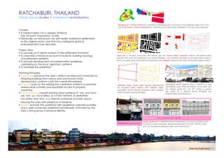
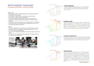
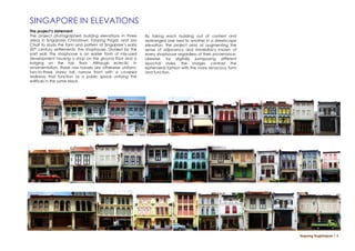
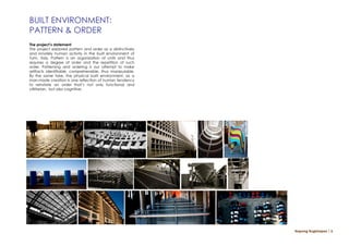
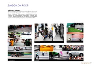
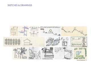
SlideShare a Scribd company logo
NAPONG RUGKHAPAN               Work Exhibit

             URBAN PLANNER.DESIGNER.PHOTOGRAPHER
         +66 081 948 1923 NRUGKHAPAN@GMAIL.COM
RATCHABURI, THAILAND
Urban block studies + waterfront revitalization

                                                                           Background + zoning ordinance: a waterfront marketplace and community as the traditional urban core of the
                                                                           city of Ratchaburi, currently designated as ‘Commercial and High-density residential in the land use zoning plan
Context
 A medium-sized city in western Thailand.
  Size: 54 sq.km. Population: 37,000
 Historically, an inland port city with earlier waterfront settlements
  as the original urban core that has undergone gradual
  redevelopment over decades.

Project Aims
 To provide an in-depth analysis of the settlement formation
 To assemble a historical account of eclectic building typology          Land use: a mix-used community with diverse uses and tenants; Block structure: uniform, fine-grained block
  and settlement patterns.                                                structure with small plot subdivisions and narrow frontages; ‘Lan’ (internal courtyard): an enclosed square within a
                                                                          block as a public space surrounded by shophouses; Lan network: enhancing the route of five public squares nearby.
 To provide development and preservation guidelines,
  capitalizing on the local ‘signature’ patterns.
 To revitalize the waterfront

Planning Principles
 Character: enhance the area’s distinct architectural character by
  retaining buildings from various eras and ensure future
  development conform s with the overall atmosphere.
 Diversity: build on the existing fine subdivision patterns to promote   Vehicular street: simple street network superimposed       Typological study: historical types of buildings by area
  diverse retail activities and equitable access to property              for motorized traffic; historic ‘Soi’ network: highly      and building cycle; reveals an eclectic mix of styles, size,
  ownership                                                               permeable, narrow informal pedestrian paths ingrained      and material dating from mid 19th century to present
                                                                          within the block, weaving frontages.                       day; makes for a dynamic skyline silhouette and
 Urban patterns: unearth existing urban patterns of ‘sois’ and ‘lans’,                                                              textured street block elevations.
  use ‘sois’ (ซอย), local alleys, as a main network of pedestrian
  circulation and ‘lans’ (ลาน), internal courtyards as public space
  imbuing the area with presence of residents.
 Vitality: activate the waterfront with pedestrian-oriented activities
  and a well-connected waterfront promenade, animated by the
  area’s strong sense of physical identity.

                                                                                                           Design guidance: form, structure, and material
                                                                                                          Design guidance for redevelopment and preservation to ensure consistency and
                                                                           Shophouses: vernacular type    continuity in urban landscape. Special focused paid to the site’s identity: small
                                                                                                          plot size, fine-grained pedestrian paths, and mixed tenure.


                                                                                                                                                                    Napong Rugkhapan │ 1
RATCHABURI, THAILAND                                              13 street segments
                                                                  The project studied 13 different street segments in the CBD of Ratchaburi
Unraveling Sidewalks: Analysis & Design                           at 5pm on a weekday. In using different analytical techniques, the project
                                                                  hoped to develop a simple set of tools to better understand and assess
                                                                  the city’s sidewalks.

Project Aims
 The project studied 13 street segments in Ratchaburi with the
  following aims and goals:
 To develop a simple, easy-to-use tool to assess the built
  environment, particularly the sidewalks;
 To unravel pedestrian experience with the sidewalks with
  thematic analyses, believing the sidewalk is ‘layered’ rather
  than flat;                                                      Pedestrian traffic
 To provide analytical techniques and design recommendations     The highest pedestrian counts (above 300), represented as red bands, took
  that are practical, actionable, and cost-effective for a town   place at the marketplace and the waterfront areas. The 2nd highest counts
  with limited capital endowment.                                 (200-300, represented as orange) were around commercial streets and
                                                                  schools. The lowest pedestrian count (0-100, represented as green)
                                                                  happened in the institutional district and areas with blank walls. The areas
Methods                                                           with the 2nd lowest count (100-200, yellow) are low- to medium-intensity
• Counting: pedestrians on streets are counted for ten minutes    land use areas with a random mix of detached housing and small retails.
  starting at 5pm on a weekday, three streets per day (5-5:10,
  5:15-5:25, 5:30-5:40 respectively).
• Measuring the sidewalk dimensions and noting where continuity
  breaks.
• Photographing: manipulating the aperture to magnify texture
  and detail of the sidewalks.
                                                                  Continuity & Spaciousness
                                                                  The sidewalks represented as blue are ones marked with uninterrupted
                                                                  continuity and good width (1.5 meters and above). The sidewalks denoted in
                                                                  pink are interrupted in part, or not wide enough (below 1.5 meters), or both.
                                                                  The sidewalks marked in dashed red lines are not continuous or unpaved.


                       Annotated maps, sketches, photographs


                                                                  Design guidance
                                                                  The study made the following recommendations. The brown sidewalks are
                                                                  those in the waterfront and old urban core, so should be designed to
                                                                  enhance interconnectivity to facilitate porous pedestrian flow. The orange
                                                                  sidewalks are to link the new commercial street, characterized by shops,
                                                                  stores, and eateries, with the waterfront to the north, thus strengthening
                                                                  the emerging axiality. Pink are sidewalks in medium- to low-density areas,
                                                                  so should be de-cluttered and tree-lined so as to animate the
                                                                  neighborhoods. Yellow are the sidewalks to be constructed. The overall
                                                                  global structure is to be achieved by interconnectivity and safe crossing at
                                                                  junctions.
                                                                                                                Napong Rugkhapan │ 2
LAEM NGOP, THAILAND
Landscape and environmental design
for stormwater management

 Context
 • A coastal town in eastern Thailand. Size: 36 sq.km.
 • High amount of stormwater runoff during raining seasons.
 • Poor quality of canal water near fishing villages.

 Project Aims
 • To provide cost-effective alternative solutions to stormwater
   management for a coastal town by introducing nonstructural
   measures such as landscape and environmental design.                                    Conceptual masterplan
 • To reduce pressure on the town’s drainage infrastructure.
 • To provide guidelines for environmental management for                                   Farmlands
                                                                                                                                             Riparian Restoration: section view
   deteriorating canal water quality.                                                                                                                                                      Zone 1: grassland
                                                                                                                                                                                           Zone 2: bushes/shrubs
 Principles                                                                                                                                                                                Zone 3: canopy trees
 • Ecological cohesion: encourages landscaped corridor of road-
   side swales and trees to help absorb runoff stormwater; protect
   soil surfaces; facilitate migration and flow of biodiversity.
 • Material: encourages use of locally-sourced and pervious
                                                                                                                                                   farmlands           Buffer         Type 1: farmlands
   surfaces for runoff to easily filter through.
                                                                                            Fishing village
 • Vitality: revitalizes community with network of tree-lined
   streetscape and rain gardens maximizing absorbent surfaces.

                                                                                                                                                                                     Type 2: Fishing village

                                                                                                                                     Canal
                                                                                             Canal and riparian restoration


                              Phase I: national highway


                              Phase II: feeder roads       Design framework: swales and landscaped corridors, phase I and phase II                             Town center concept plan: green infrastructure

                                                                                                                                                                                  Napong Rugkhapan │ 3
English Deprivation Indices 2007
Discussing correlations


  The project’s summary
  Using London as a case study, the report looks at a number of
  domains in the English Deprivation Indices 2007 and their score
  mappings: Employment, Education, and Health. Rather than
  trying to establish a causation between two or more indices of
  Deprivation, the report shows that the relationship is more
  complex and not necessarily bivariate (and in fact,
  multivariate most of the time). That is, while it is relatively safe
  to say that Employment Deprivation (map 1) reflects Income
  Deprivation (map 4) (considering employment as a main
  source of income), it is much trickier to conclude that                1                    2
  Education Deprivation (map 2) causes Employment
  Deprivation (map 1). Working through different domain-
  pairings, the report attempts to debunk complex realities by
  identifying the spurious correlations. The report concludes that,
  while one Deprivation domain is not directly caused by
  another, the existence of two or more Deprivation domains in
  a given area points to other intervening factors at work e.g.
  the geography of ethnicity and ethnic diversity index (map 5).


                                                                         3
                                                                                             4


                                                                         5
                                                                                             6


                                                                             Napong Rugkhapan │ 4
SINGAPORE IN ELEVATIONS
The project’s statement
The project photographed building elevations in three      By taking each building out of context and
areas in Singapore: Chinatown, Tanjong Pagar, and Joo      rearranged one next to another in a streetscape
Chiat to study the form and pattern of Singapore’s early   elevation, the project aims at augmenting the
20th century settlements: the shophouse. Divided by the    sense of adjacency and immediacy known of
part wall, the shophouse is an earlier form of mix-used    every shophouse regardless of their provenance.
development housing a shop on the ground floor and a       Likewise, by digitally juxtaposing different
lodging on the top floor. Although eclectic in             epochal styles, the images contrast the
ornamentation, these row houses are otherwise uniform;     ephemeral fashion with the more tenacious form
two-to-three storey tall, narrow front with a covered      and function.
walkway that function as a public space unifying the
edifices in the same block.


                                                                                                             Napong Rugkhapan │ 5
BUILT ENVIRONMENT:
PATTERN & ORDER
The project’s statement
The project explored pattern and order as a distinctively
and innately human activity in the built environment of
Turin, Italy. Pattern is an organization of units and thus
requires a degree of order and the repetition of such
order. Patterning and ordering is our attempt to make
artifacts identifiable, comprehensible, thus manipulable.
By the same toke, the physical built environment, as a
man-made creation is one reflection of human tendency
to reinstate an order that’s not only functional and
utilitarian, but also cognitive.


                                                             Napong Rugkhapan │ 6
SAIGON ON FOOT

The project’s statement
The project documented four recurring themes frequently
encountered in the public realm – streets and sidewalks –
during a daytime walking tour of Saigon, Vietnam. The
themes are Congregation, Backstreets, Texture, and
Crossing. The photographs are an attempt to capture the
senses and dynamism of Saigon on November 23, 2010.


                                                     Backstreets   Texture


Congregation                                         Crossing

                                                                             Napong Rugkhapan │ 7
SKETCHES & DRAWINGS


                      Napong Rugkhapan │ 8
Conceptual Photomontage
Possibilities for waterfront revitalization


                                              Napong Rugkhapan │ 9

More Related Content

What's hot

Zahran heritage design guidelines
Zahran heritage design guidelines Zahran heritage design guidelines
Zahran heritage design guidelines
Dania Abdel-aziz
 
Planning Theories presents in the city UJJAIN
Planning Theories presents in the city UJJAINPlanning Theories presents in the city UJJAIN
Planning Theories presents in the city UJJAIN
Praveen Mukati
 
Form based codes huntington
Form based codes huntingtonForm based codes huntington
Form based codes huntington
pingme1x
 
Theory project-2-analytical-paper
Theory project-2-analytical-paperTheory project-2-analytical-paper
Theory project-2-analytical-paper
kerneng
 
Duaccccccccc
DuacccccccccDuaccccccccc
Duaccccccccc
Manveen Kaur
 
Urban design
Urban designUrban design
Urban design
akshay KHADKE
 
Recreation of Missed Space
Recreation of Missed SpaceRecreation of Missed Space
Recreation of Missed Space
Ghazal Fateh
 
Urban Design Study
Urban Design StudyUrban Design Study
Urban Design Study
Aaron Michael O'Neil
 
Bradford tod ca gbc 20120324 v2
Bradford tod ca gbc 20120324 v2Bradford tod ca gbc 20120324 v2
Bradford tod ca gbc 20120324 v2
Toronto 2030 District
 
Form based codes intro
Form based codes introForm based codes intro
Form based codes intro
Trailnet
 
Radburn
RadburnRadburn
Forms of human settelments
Forms of human settelmentsForms of human settelments
Forms of human settelments
Simran Vats
 
ANANT RAJE
ANANT RAJEANANT RAJE
ANANT RAJE
KartikAlawadhi
 
Chandigarh: grid iron pattern
Chandigarh: grid iron patternChandigarh: grid iron pattern
Chandigarh: grid iron pattern
Satyam Rai
 
Urban restructuring (Mohalla baazi forum)
Urban restructuring (Mohalla baazi forum)Urban restructuring (Mohalla baazi forum)
Urban restructuring (Mohalla baazi forum)
Nouman Tufail
 
James Joyce - Landscape Architecture Portfolio
James Joyce - Landscape Architecture PortfolioJames Joyce - Landscape Architecture Portfolio
James Joyce - Landscape Architecture Portfolio
James Joyce, RLA
 
Finis Ray Design Portfolio
Finis Ray Design PortfolioFinis Ray Design Portfolio
Finis Ray Design Portfolio
fray88
 
Charles correa
Charles correaCharles correa
Charles correa
padamatikona swapnika
 
Introduction to Form Based Codes
Introduction to Form Based CodesIntroduction to Form Based Codes
PROJECT 2: THE IMAGE OF THE CITY
PROJECT 2: THE IMAGE OF THE CITYPROJECT 2: THE IMAGE OF THE CITY
PROJECT 2: THE IMAGE OF THE CITY
huiyuteoh
 

What's hot (20)

Zahran heritage design guidelines
Zahran heritage design guidelines Zahran heritage design guidelines
Zahran heritage design guidelines
 
Planning Theories presents in the city UJJAIN
Planning Theories presents in the city UJJAINPlanning Theories presents in the city UJJAIN
Planning Theories presents in the city UJJAIN
 
Form based codes huntington
Form based codes huntingtonForm based codes huntington
Form based codes huntington
 
Theory project-2-analytical-paper
Theory project-2-analytical-paperTheory project-2-analytical-paper
Theory project-2-analytical-paper
 
Duaccccccccc
DuacccccccccDuaccccccccc
Duaccccccccc
 
Urban design
Urban designUrban design
Urban design
 
Recreation of Missed Space
Recreation of Missed SpaceRecreation of Missed Space
Recreation of Missed Space
 
Urban Design Study
Urban Design StudyUrban Design Study
Urban Design Study
 
Bradford tod ca gbc 20120324 v2
Bradford tod ca gbc 20120324 v2Bradford tod ca gbc 20120324 v2
Bradford tod ca gbc 20120324 v2
 
Form based codes intro
Form based codes introForm based codes intro
Form based codes intro
 
Radburn
RadburnRadburn
Radburn
 
Forms of human settelments
Forms of human settelmentsForms of human settelments
Forms of human settelments
 
ANANT RAJE
ANANT RAJEANANT RAJE
ANANT RAJE
 
Chandigarh: grid iron pattern
Chandigarh: grid iron patternChandigarh: grid iron pattern
Chandigarh: grid iron pattern
 
Urban restructuring (Mohalla baazi forum)
Urban restructuring (Mohalla baazi forum)Urban restructuring (Mohalla baazi forum)
Urban restructuring (Mohalla baazi forum)
 
James Joyce - Landscape Architecture Portfolio
James Joyce - Landscape Architecture PortfolioJames Joyce - Landscape Architecture Portfolio
James Joyce - Landscape Architecture Portfolio
 
Finis Ray Design Portfolio
Finis Ray Design PortfolioFinis Ray Design Portfolio
Finis Ray Design Portfolio
 
Charles correa
Charles correaCharles correa
Charles correa
 
Introduction to Form Based Codes
Introduction to Form Based CodesIntroduction to Form Based Codes
Introduction to Form Based Codes
 
PROJECT 2: THE IMAGE OF THE CITY
PROJECT 2: THE IMAGE OF THE CITYPROJECT 2: THE IMAGE OF THE CITY
PROJECT 2: THE IMAGE OF THE CITY
 

Viewers also liked

เครือข่ายสังคมออนไลน์
เครือข่ายสังคมออนไลน์เครือข่ายสังคมออนไลน์
เครือข่ายสังคมออนไลน์
PangMy
 
จริยธรรมและคุณธรรมในการใช้อินเทอร์เน็ต
จริยธรรมและคุณธรรมในการใช้อินเทอร์เน็ตจริยธรรมและคุณธรรมในการใช้อินเทอร์เน็ต
จริยธรรมและคุณธรรมในการใช้อินเทอร์เน็ต
PangMy
 
เครือข่ายสังคมออนไลน์ 3
เครือข่ายสังคมออนไลน์ 3เครือข่ายสังคมออนไลน์ 3
เครือข่ายสังคมออนไลน์ 3PangMy
 
เครือข่ายสังคมออนไลน์
เครือข่ายสังคมออนไลน์เครือข่ายสังคมออนไลน์
เครือข่ายสังคมออนไลน์
PangMy
 
Adriana inter d222
Adriana inter d222Adriana inter d222
Adriana inter d222
AdiOnita
 
เครือข่ายสังคมออนไลน์ (2)
เครือข่ายสังคมออนไลน์ (2)เครือข่ายสังคมออนไลน์ (2)
เครือข่ายสังคมออนไลน์ (2)
PangMy
 
Rodchenko
RodchenkoRodchenko
Rodchenko
AdiOnita
 
Crime film
Crime filmCrime film
Crime film
AdiOnita
 
Botnet
BotnetBotnet
Botnet
PangMy
 
Wacke ( graywacke)
Wacke ( graywacke)Wacke ( graywacke)
Wacke ( graywacke)
Mohit Kumar
 
การค้นหาข้อมูลจากอินเทอร์เน็ต
การค้นหาข้อมูลจากอินเทอร์เน็ตการค้นหาข้อมูลจากอินเทอร์เน็ต
การค้นหาข้อมูลจากอินเทอร์เน็ตPangMy
 
Wacke ( graywacke)
Wacke ( graywacke)Wacke ( graywacke)
Wacke ( graywacke)
Mohit Kumar
 
Borehole Geophysical Techniques
Borehole Geophysical TechniquesBorehole Geophysical Techniques
Borehole Geophysical Techniques
Mohit Kumar
 
Advances in ms excel
Advances in ms excelAdvances in ms excel
Advances in ms excel
Mohit Kumar
 
Classification of igneous rocks
Classification of igneous rocksClassification of igneous rocks
Classification of igneous rocks
Mohit Kumar
 

Viewers also liked (15)

เครือข่ายสังคมออนไลน์
เครือข่ายสังคมออนไลน์เครือข่ายสังคมออนไลน์
เครือข่ายสังคมออนไลน์
 
จริยธรรมและคุณธรรมในการใช้อินเทอร์เน็ต
จริยธรรมและคุณธรรมในการใช้อินเทอร์เน็ตจริยธรรมและคุณธรรมในการใช้อินเทอร์เน็ต
จริยธรรมและคุณธรรมในการใช้อินเทอร์เน็ต
 
เครือข่ายสังคมออนไลน์ 3
เครือข่ายสังคมออนไลน์ 3เครือข่ายสังคมออนไลน์ 3
เครือข่ายสังคมออนไลน์ 3
 
เครือข่ายสังคมออนไลน์
เครือข่ายสังคมออนไลน์เครือข่ายสังคมออนไลน์
เครือข่ายสังคมออนไลน์
 
Adriana inter d222
Adriana inter d222Adriana inter d222
Adriana inter d222
 
เครือข่ายสังคมออนไลน์ (2)
เครือข่ายสังคมออนไลน์ (2)เครือข่ายสังคมออนไลน์ (2)
เครือข่ายสังคมออนไลน์ (2)
 
Rodchenko
RodchenkoRodchenko
Rodchenko
 
Crime film
Crime filmCrime film
Crime film
 
Botnet
BotnetBotnet
Botnet
 
Wacke ( graywacke)
Wacke ( graywacke)Wacke ( graywacke)
Wacke ( graywacke)
 
การค้นหาข้อมูลจากอินเทอร์เน็ต
การค้นหาข้อมูลจากอินเทอร์เน็ตการค้นหาข้อมูลจากอินเทอร์เน็ต
การค้นหาข้อมูลจากอินเทอร์เน็ต
 
Wacke ( graywacke)
Wacke ( graywacke)Wacke ( graywacke)
Wacke ( graywacke)
 
Borehole Geophysical Techniques
Borehole Geophysical TechniquesBorehole Geophysical Techniques
Borehole Geophysical Techniques
 
Advances in ms excel
Advances in ms excelAdvances in ms excel
Advances in ms excel
 
Classification of igneous rocks
Classification of igneous rocksClassification of igneous rocks
Classification of igneous rocks
 

Similar to Work Exhibit

Urban Design at different levels of Planning
Urban Design at different levels of PlanningUrban Design at different levels of Planning
Urban Design at different levels of Planning
Yajush Sonar
 
12-13 Masterplan and Details
12-13 Masterplan and Details12-13 Masterplan and Details
12-13 Masterplan and Details
Amr Alaaeldin Elesawy
 
High Density and Livability: Lessons Learned in Asian Cities (Sujata Govada) ...
High Density and Livability: Lessons Learned in Asian Cities (Sujata Govada) ...High Density and Livability: Lessons Learned in Asian Cities (Sujata Govada) ...
High Density and Livability: Lessons Learned in Asian Cities (Sujata Govada) ...
Virtual ULI
 
Urban Design Scales and Spaces for Architecture
Urban Design Scales and Spaces for ArchitectureUrban Design Scales and Spaces for Architecture
Urban Design Scales and Spaces for Architecture
Mimi Alguidano
 
Urban design
Urban designUrban design
Urban design
Ayaz Khan
 
CONSCIOUS URBANISM
CONSCIOUS  URBANISMCONSCIOUS  URBANISM
CONSCIOUS URBANISM
Nilanjan Bhowal
 
Urban Landscape Elements
Urban Landscape ElementsUrban Landscape Elements
Urban Landscape Elements
hussaini119032
 
assignment 1 streetscape.pptx
assignment 1 streetscape.pptxassignment 1 streetscape.pptx
assignment 1 streetscape.pptx
SwatiThakur315700
 
Real Estate Development: David Burney
Real Estate Development: David BurneyReal Estate Development: David Burney
Real Estate Development: David Burney
urbansystemssymposium
 
Introduction to the Towards Successful Suburban Town Centres Project at UCL
Introduction to the Towards Successful Suburban Town Centres Project at UCLIntroduction to the Towards Successful Suburban Town Centres Project at UCL
Introduction to the Towards Successful Suburban Town Centres Project at UCL
University College London
 
PPPF222.pptx
PPPF222.pptxPPPF222.pptx
PPPF222.pptx
BossGold
 
Portfolio
PortfolioPortfolio
Portfolio
louisav29
 
significance of design strategies and guidlines.pptx
significance of design strategies and guidlines.pptxsignificance of design strategies and guidlines.pptx
significance of design strategies and guidlines.pptx
DAHIRMUMINALIRA23122
 
WINSEM2023-24_BHUM108L_TH_VL2023240505273_2024-02-08_Reference-Material-I.pptx
WINSEM2023-24_BHUM108L_TH_VL2023240505273_2024-02-08_Reference-Material-I.pptxWINSEM2023-24_BHUM108L_TH_VL2023240505273_2024-02-08_Reference-Material-I.pptx
WINSEM2023-24_BHUM108L_TH_VL2023240505273_2024-02-08_Reference-Material-I.pptx
sparshofficialwork
 
Case study space syntax
Case study space syntaxCase study space syntax
Case study space syntax
Shomou' Aljizawi
 
Portfolio 2016 spreads
Portfolio 2016 spreadsPortfolio 2016 spreads
Portfolio 2016 spreads
sush013
 
NACTO Urban Street Design Guide
NACTO Urban Street Design GuideNACTO Urban Street Design Guide
NACTO Urban Street Design Guide
Jesse Budlong
 
New Urbanism 1.pdf
New Urbanism 1.pdfNew Urbanism 1.pdf
250391567-Intro-Scope-and-Objectives.pptx
250391567-Intro-Scope-and-Objectives.pptx250391567-Intro-Scope-and-Objectives.pptx
250391567-Intro-Scope-and-Objectives.pptx
MussemaAbdurazak
 
Trial for online
Trial for onlineTrial for online
Trial for online
elogilvie
 

Similar to Work Exhibit (20)

Urban Design at different levels of Planning
Urban Design at different levels of PlanningUrban Design at different levels of Planning
Urban Design at different levels of Planning
 
12-13 Masterplan and Details
12-13 Masterplan and Details12-13 Masterplan and Details
12-13 Masterplan and Details
 
High Density and Livability: Lessons Learned in Asian Cities (Sujata Govada) ...
High Density and Livability: Lessons Learned in Asian Cities (Sujata Govada) ...High Density and Livability: Lessons Learned in Asian Cities (Sujata Govada) ...
High Density and Livability: Lessons Learned in Asian Cities (Sujata Govada) ...
 
Urban Design Scales and Spaces for Architecture
Urban Design Scales and Spaces for ArchitectureUrban Design Scales and Spaces for Architecture
Urban Design Scales and Spaces for Architecture
 
Urban design
Urban designUrban design
Urban design
 
CONSCIOUS URBANISM
CONSCIOUS  URBANISMCONSCIOUS  URBANISM
CONSCIOUS URBANISM
 
Urban Landscape Elements
Urban Landscape ElementsUrban Landscape Elements
Urban Landscape Elements
 
assignment 1 streetscape.pptx
assignment 1 streetscape.pptxassignment 1 streetscape.pptx
assignment 1 streetscape.pptx
 
Real Estate Development: David Burney
Real Estate Development: David BurneyReal Estate Development: David Burney
Real Estate Development: David Burney
 
Introduction to the Towards Successful Suburban Town Centres Project at UCL
Introduction to the Towards Successful Suburban Town Centres Project at UCLIntroduction to the Towards Successful Suburban Town Centres Project at UCL
Introduction to the Towards Successful Suburban Town Centres Project at UCL
 
PPPF222.pptx
PPPF222.pptxPPPF222.pptx
PPPF222.pptx
 
Portfolio
PortfolioPortfolio
Portfolio
 
significance of design strategies and guidlines.pptx
significance of design strategies and guidlines.pptxsignificance of design strategies and guidlines.pptx
significance of design strategies and guidlines.pptx
 
WINSEM2023-24_BHUM108L_TH_VL2023240505273_2024-02-08_Reference-Material-I.pptx
WINSEM2023-24_BHUM108L_TH_VL2023240505273_2024-02-08_Reference-Material-I.pptxWINSEM2023-24_BHUM108L_TH_VL2023240505273_2024-02-08_Reference-Material-I.pptx
WINSEM2023-24_BHUM108L_TH_VL2023240505273_2024-02-08_Reference-Material-I.pptx
 
Case study space syntax
Case study space syntaxCase study space syntax
Case study space syntax
 
Portfolio 2016 spreads
Portfolio 2016 spreadsPortfolio 2016 spreads
Portfolio 2016 spreads
 
NACTO Urban Street Design Guide
NACTO Urban Street Design GuideNACTO Urban Street Design Guide
NACTO Urban Street Design Guide
 
New Urbanism 1.pdf
New Urbanism 1.pdfNew Urbanism 1.pdf
New Urbanism 1.pdf
 
250391567-Intro-Scope-and-Objectives.pptx
250391567-Intro-Scope-and-Objectives.pptx250391567-Intro-Scope-and-Objectives.pptx
250391567-Intro-Scope-and-Objectives.pptx
 
Trial for online
Trial for onlineTrial for online
Trial for online
 

Work Exhibit

  • 1. NAPONG RUGKHAPAN Work Exhibit URBAN PLANNER.DESIGNER.PHOTOGRAPHER +66 081 948 1923 NRUGKHAPAN@GMAIL.COM
  • 2. RATCHABURI, THAILAND Urban block studies + waterfront revitalization Background + zoning ordinance: a waterfront marketplace and community as the traditional urban core of the city of Ratchaburi, currently designated as ‘Commercial and High-density residential in the land use zoning plan Context  A medium-sized city in western Thailand. Size: 54 sq.km. Population: 37,000  Historically, an inland port city with earlier waterfront settlements as the original urban core that has undergone gradual redevelopment over decades. Project Aims  To provide an in-depth analysis of the settlement formation  To assemble a historical account of eclectic building typology Land use: a mix-used community with diverse uses and tenants; Block structure: uniform, fine-grained block and settlement patterns. structure with small plot subdivisions and narrow frontages; ‘Lan’ (internal courtyard): an enclosed square within a block as a public space surrounded by shophouses; Lan network: enhancing the route of five public squares nearby.  To provide development and preservation guidelines, capitalizing on the local ‘signature’ patterns.  To revitalize the waterfront Planning Principles  Character: enhance the area’s distinct architectural character by retaining buildings from various eras and ensure future development conform s with the overall atmosphere.  Diversity: build on the existing fine subdivision patterns to promote Vehicular street: simple street network superimposed Typological study: historical types of buildings by area diverse retail activities and equitable access to property for motorized traffic; historic ‘Soi’ network: highly and building cycle; reveals an eclectic mix of styles, size, ownership permeable, narrow informal pedestrian paths ingrained and material dating from mid 19th century to present within the block, weaving frontages. day; makes for a dynamic skyline silhouette and  Urban patterns: unearth existing urban patterns of ‘sois’ and ‘lans’, textured street block elevations. use ‘sois’ (ซอย), local alleys, as a main network of pedestrian circulation and ‘lans’ (ลาน), internal courtyards as public space imbuing the area with presence of residents.  Vitality: activate the waterfront with pedestrian-oriented activities and a well-connected waterfront promenade, animated by the area’s strong sense of physical identity. Design guidance: form, structure, and material Design guidance for redevelopment and preservation to ensure consistency and Shophouses: vernacular type continuity in urban landscape. Special focused paid to the site’s identity: small plot size, fine-grained pedestrian paths, and mixed tenure. Napong Rugkhapan │ 1
  • 3. RATCHABURI, THAILAND 13 street segments The project studied 13 different street segments in the CBD of Ratchaburi Unraveling Sidewalks: Analysis & Design at 5pm on a weekday. In using different analytical techniques, the project hoped to develop a simple set of tools to better understand and assess the city’s sidewalks. Project Aims  The project studied 13 street segments in Ratchaburi with the following aims and goals:  To develop a simple, easy-to-use tool to assess the built environment, particularly the sidewalks;  To unravel pedestrian experience with the sidewalks with thematic analyses, believing the sidewalk is ‘layered’ rather than flat; Pedestrian traffic  To provide analytical techniques and design recommendations The highest pedestrian counts (above 300), represented as red bands, took that are practical, actionable, and cost-effective for a town place at the marketplace and the waterfront areas. The 2nd highest counts with limited capital endowment. (200-300, represented as orange) were around commercial streets and schools. The lowest pedestrian count (0-100, represented as green) happened in the institutional district and areas with blank walls. The areas Methods with the 2nd lowest count (100-200, yellow) are low- to medium-intensity • Counting: pedestrians on streets are counted for ten minutes land use areas with a random mix of detached housing and small retails. starting at 5pm on a weekday, three streets per day (5-5:10, 5:15-5:25, 5:30-5:40 respectively). • Measuring the sidewalk dimensions and noting where continuity breaks. • Photographing: manipulating the aperture to magnify texture and detail of the sidewalks. Continuity & Spaciousness The sidewalks represented as blue are ones marked with uninterrupted continuity and good width (1.5 meters and above). The sidewalks denoted in pink are interrupted in part, or not wide enough (below 1.5 meters), or both. The sidewalks marked in dashed red lines are not continuous or unpaved. Annotated maps, sketches, photographs Design guidance The study made the following recommendations. The brown sidewalks are those in the waterfront and old urban core, so should be designed to enhance interconnectivity to facilitate porous pedestrian flow. The orange sidewalks are to link the new commercial street, characterized by shops, stores, and eateries, with the waterfront to the north, thus strengthening the emerging axiality. Pink are sidewalks in medium- to low-density areas, so should be de-cluttered and tree-lined so as to animate the neighborhoods. Yellow are the sidewalks to be constructed. The overall global structure is to be achieved by interconnectivity and safe crossing at junctions. Napong Rugkhapan │ 2
  • 4. LAEM NGOP, THAILAND Landscape and environmental design for stormwater management Context • A coastal town in eastern Thailand. Size: 36 sq.km. • High amount of stormwater runoff during raining seasons. • Poor quality of canal water near fishing villages. Project Aims • To provide cost-effective alternative solutions to stormwater management for a coastal town by introducing nonstructural measures such as landscape and environmental design. Conceptual masterplan • To reduce pressure on the town’s drainage infrastructure. • To provide guidelines for environmental management for Farmlands Riparian Restoration: section view deteriorating canal water quality. Zone 1: grassland Zone 2: bushes/shrubs Principles Zone 3: canopy trees • Ecological cohesion: encourages landscaped corridor of road- side swales and trees to help absorb runoff stormwater; protect soil surfaces; facilitate migration and flow of biodiversity. • Material: encourages use of locally-sourced and pervious farmlands Buffer Type 1: farmlands surfaces for runoff to easily filter through. Fishing village • Vitality: revitalizes community with network of tree-lined streetscape and rain gardens maximizing absorbent surfaces. Type 2: Fishing village Canal Canal and riparian restoration Phase I: national highway Phase II: feeder roads Design framework: swales and landscaped corridors, phase I and phase II Town center concept plan: green infrastructure Napong Rugkhapan │ 3
  • 5. English Deprivation Indices 2007 Discussing correlations The project’s summary Using London as a case study, the report looks at a number of domains in the English Deprivation Indices 2007 and their score mappings: Employment, Education, and Health. Rather than trying to establish a causation between two or more indices of Deprivation, the report shows that the relationship is more complex and not necessarily bivariate (and in fact, multivariate most of the time). That is, while it is relatively safe to say that Employment Deprivation (map 1) reflects Income Deprivation (map 4) (considering employment as a main source of income), it is much trickier to conclude that 1 2 Education Deprivation (map 2) causes Employment Deprivation (map 1). Working through different domain- pairings, the report attempts to debunk complex realities by identifying the spurious correlations. The report concludes that, while one Deprivation domain is not directly caused by another, the existence of two or more Deprivation domains in a given area points to other intervening factors at work e.g. the geography of ethnicity and ethnic diversity index (map 5). 3 4 5 6 Napong Rugkhapan │ 4
  • 6. SINGAPORE IN ELEVATIONS The project’s statement The project photographed building elevations in three By taking each building out of context and areas in Singapore: Chinatown, Tanjong Pagar, and Joo rearranged one next to another in a streetscape Chiat to study the form and pattern of Singapore’s early elevation, the project aims at augmenting the 20th century settlements: the shophouse. Divided by the sense of adjacency and immediacy known of part wall, the shophouse is an earlier form of mix-used every shophouse regardless of their provenance. development housing a shop on the ground floor and a Likewise, by digitally juxtaposing different lodging on the top floor. Although eclectic in epochal styles, the images contrast the ornamentation, these row houses are otherwise uniform; ephemeral fashion with the more tenacious form two-to-three storey tall, narrow front with a covered and function. walkway that function as a public space unifying the edifices in the same block. Napong Rugkhapan │ 5
  • 7. BUILT ENVIRONMENT: PATTERN & ORDER The project’s statement The project explored pattern and order as a distinctively and innately human activity in the built environment of Turin, Italy. Pattern is an organization of units and thus requires a degree of order and the repetition of such order. Patterning and ordering is our attempt to make artifacts identifiable, comprehensible, thus manipulable. By the same toke, the physical built environment, as a man-made creation is one reflection of human tendency to reinstate an order that’s not only functional and utilitarian, but also cognitive. Napong Rugkhapan │ 6
  • 8. SAIGON ON FOOT The project’s statement The project documented four recurring themes frequently encountered in the public realm – streets and sidewalks – during a daytime walking tour of Saigon, Vietnam. The themes are Congregation, Backstreets, Texture, and Crossing. The photographs are an attempt to capture the senses and dynamism of Saigon on November 23, 2010. Backstreets Texture Congregation Crossing Napong Rugkhapan │ 7
  • 9. SKETCHES & DRAWINGS Napong Rugkhapan │ 8
  • 10. Conceptual Photomontage Possibilities for waterfront revitalization Napong Rugkhapan │ 9