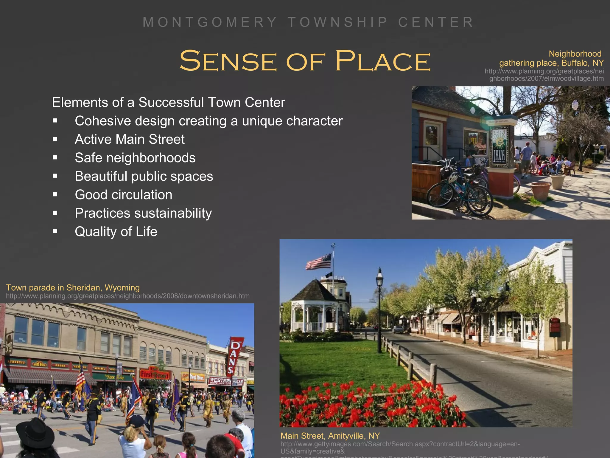
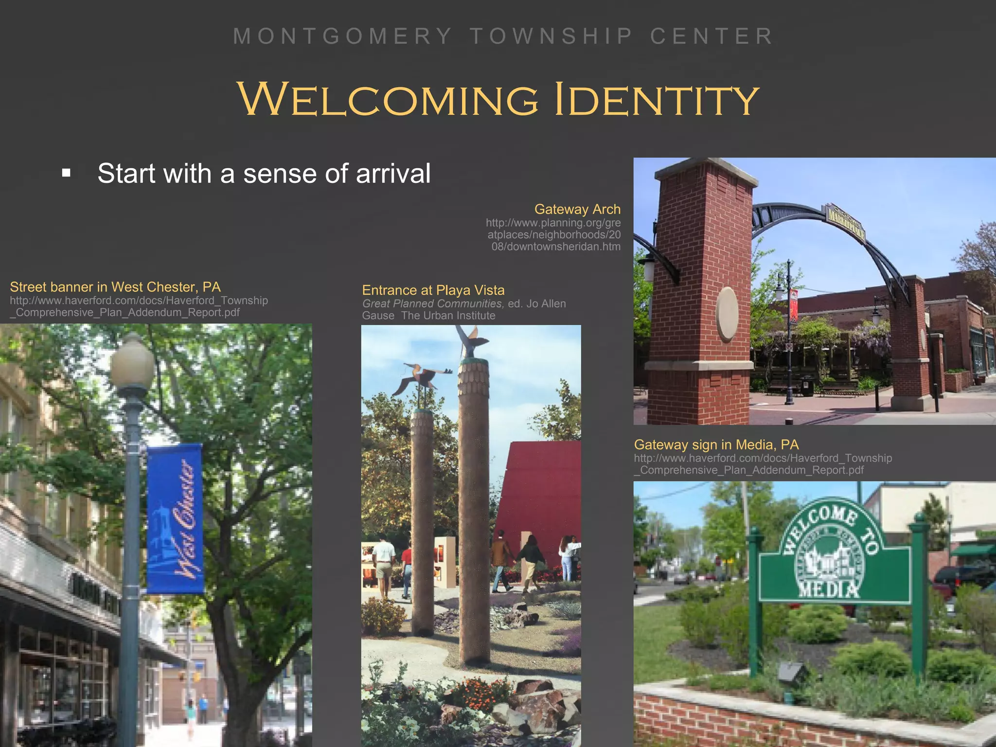
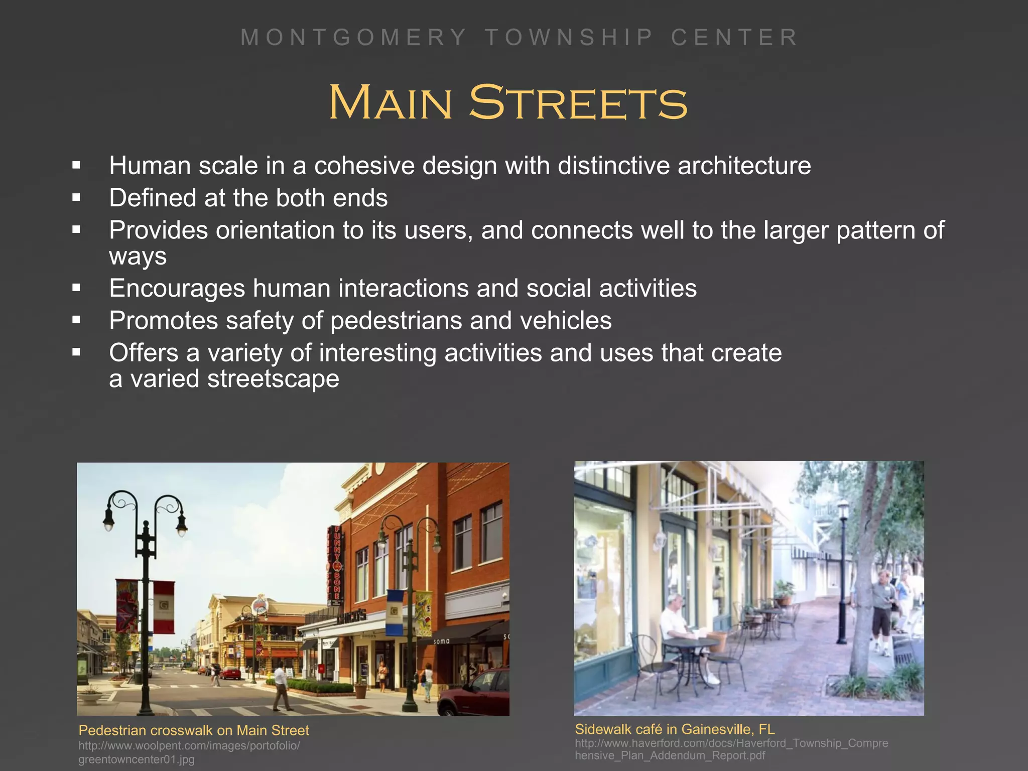
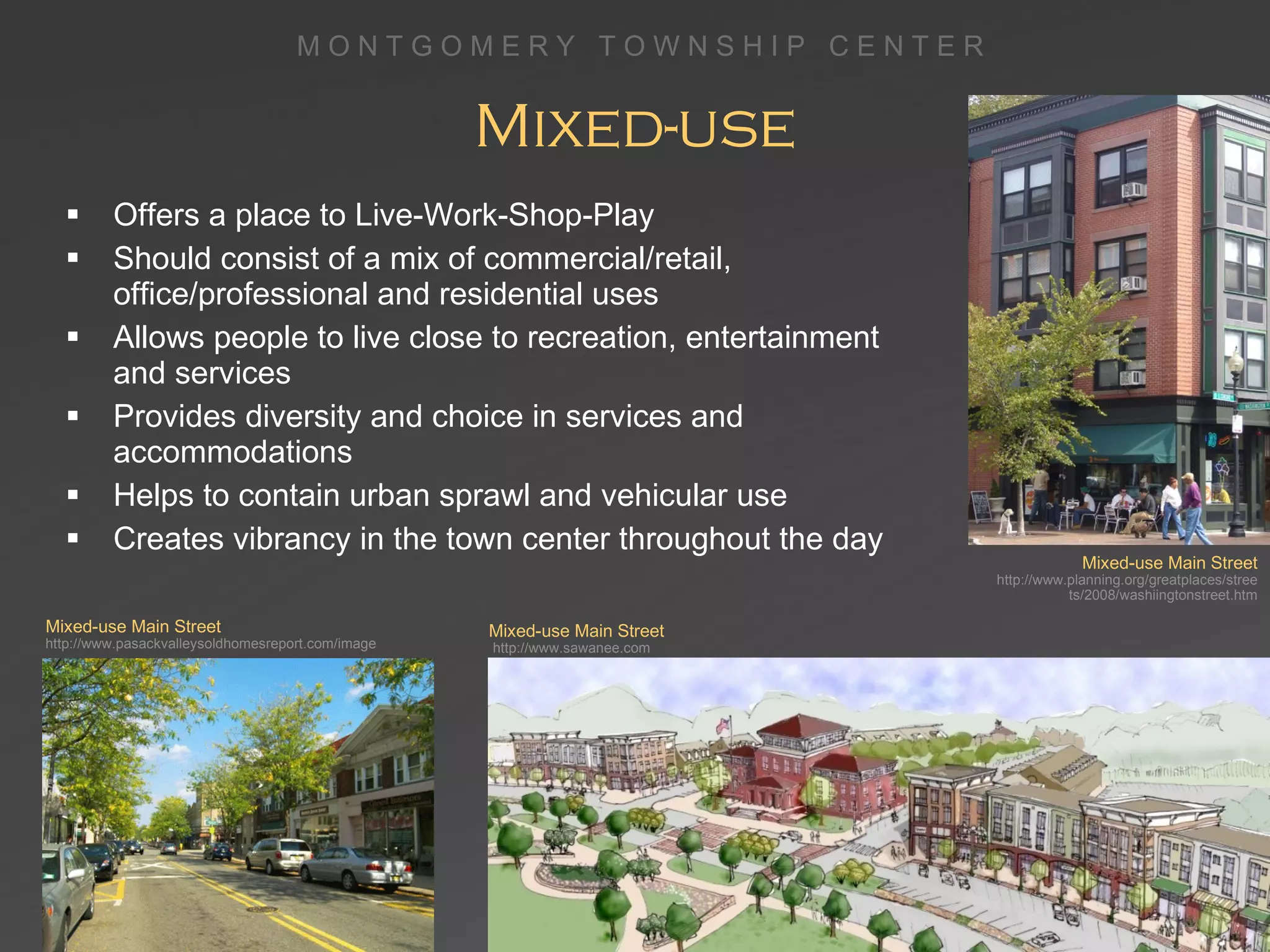
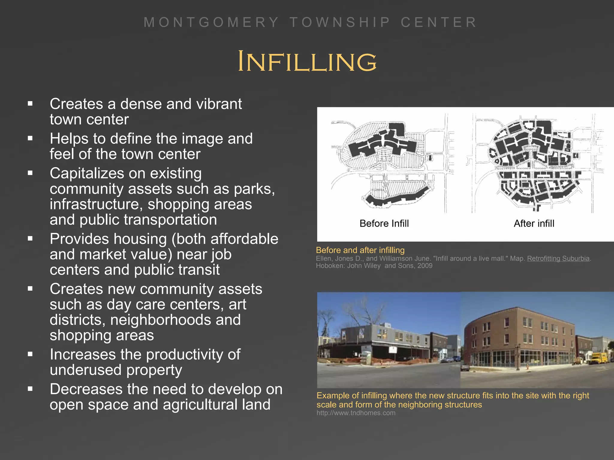
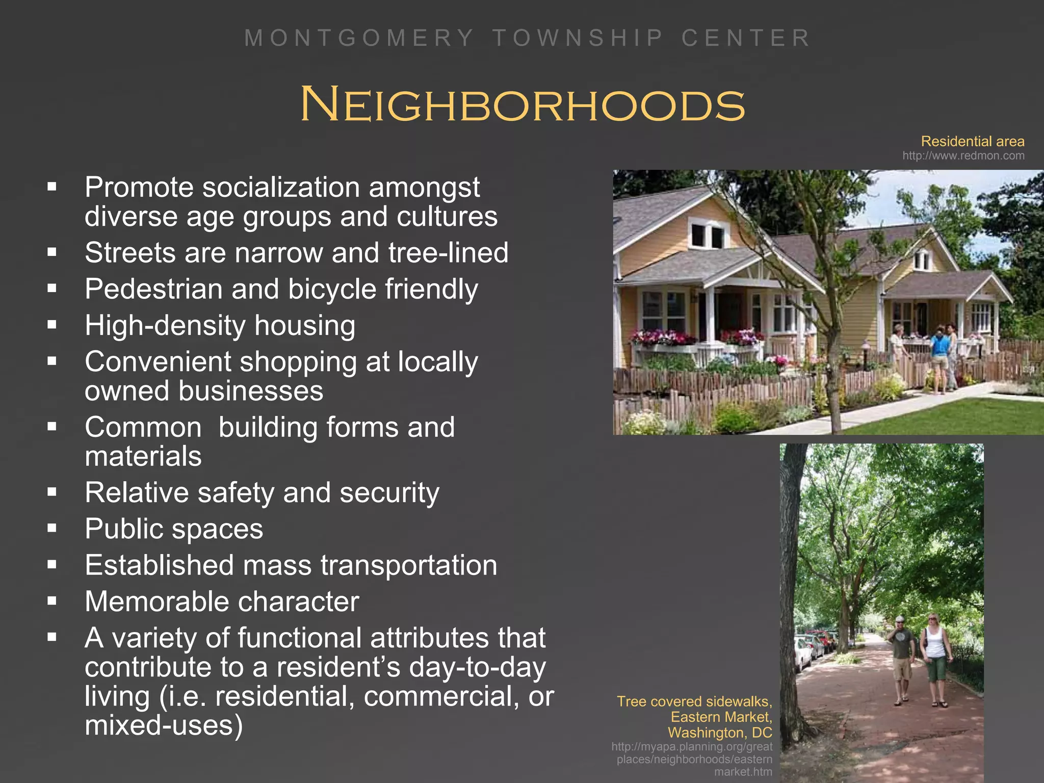
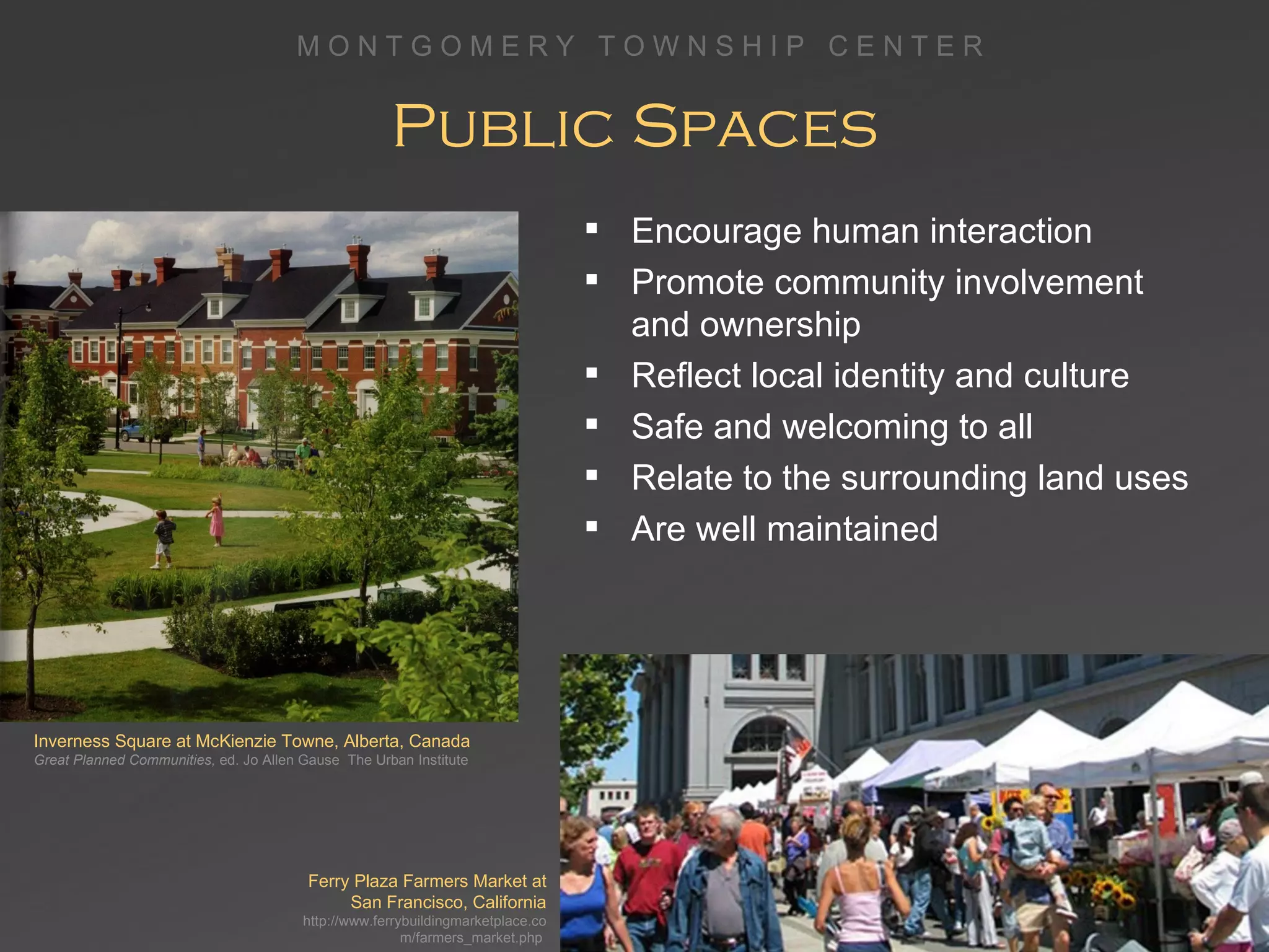
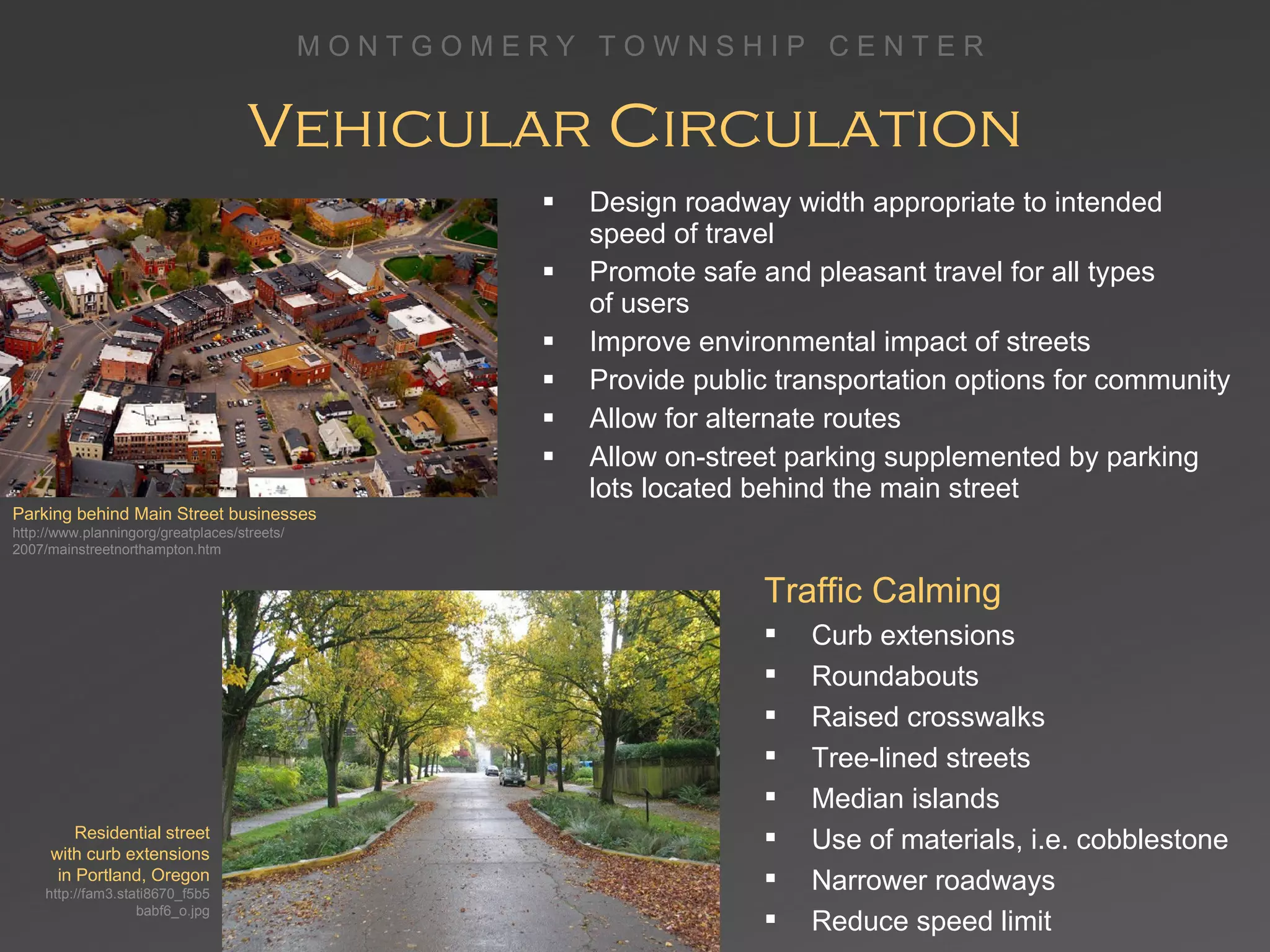
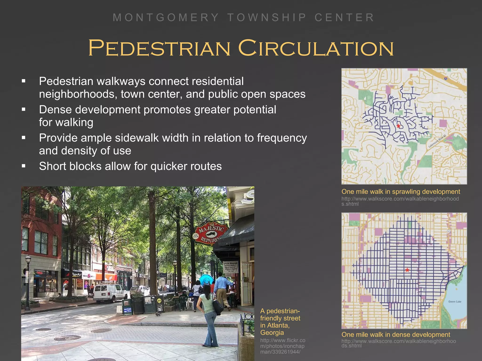
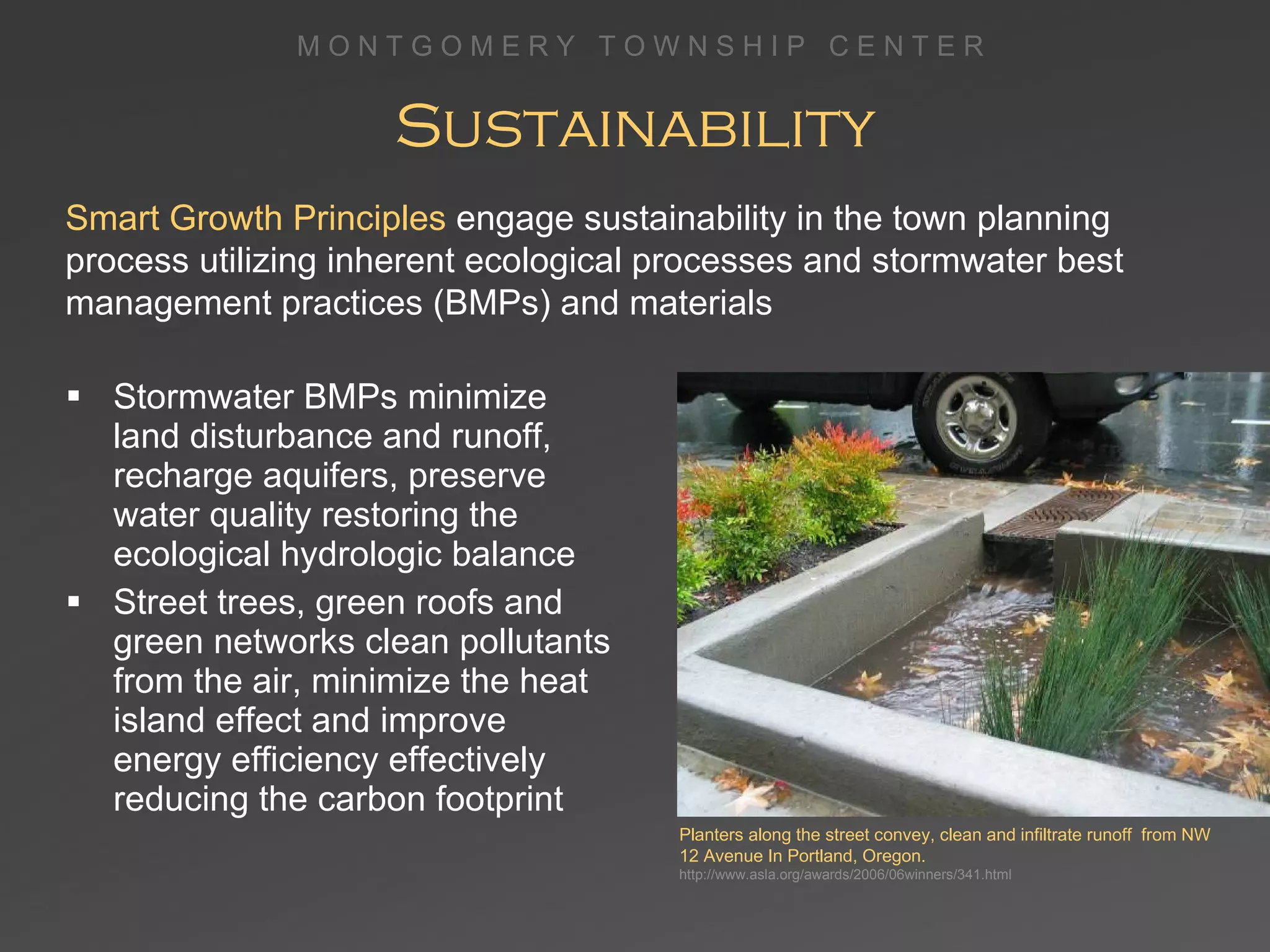
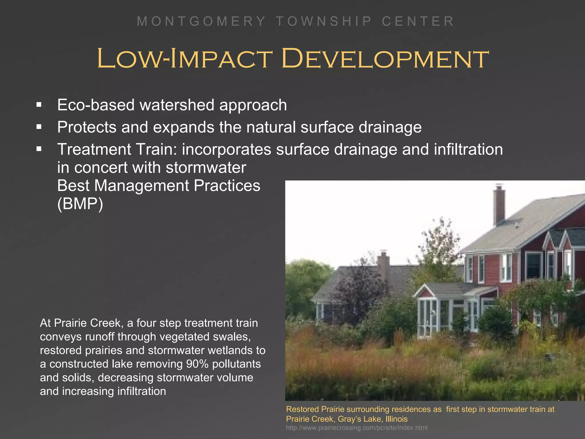
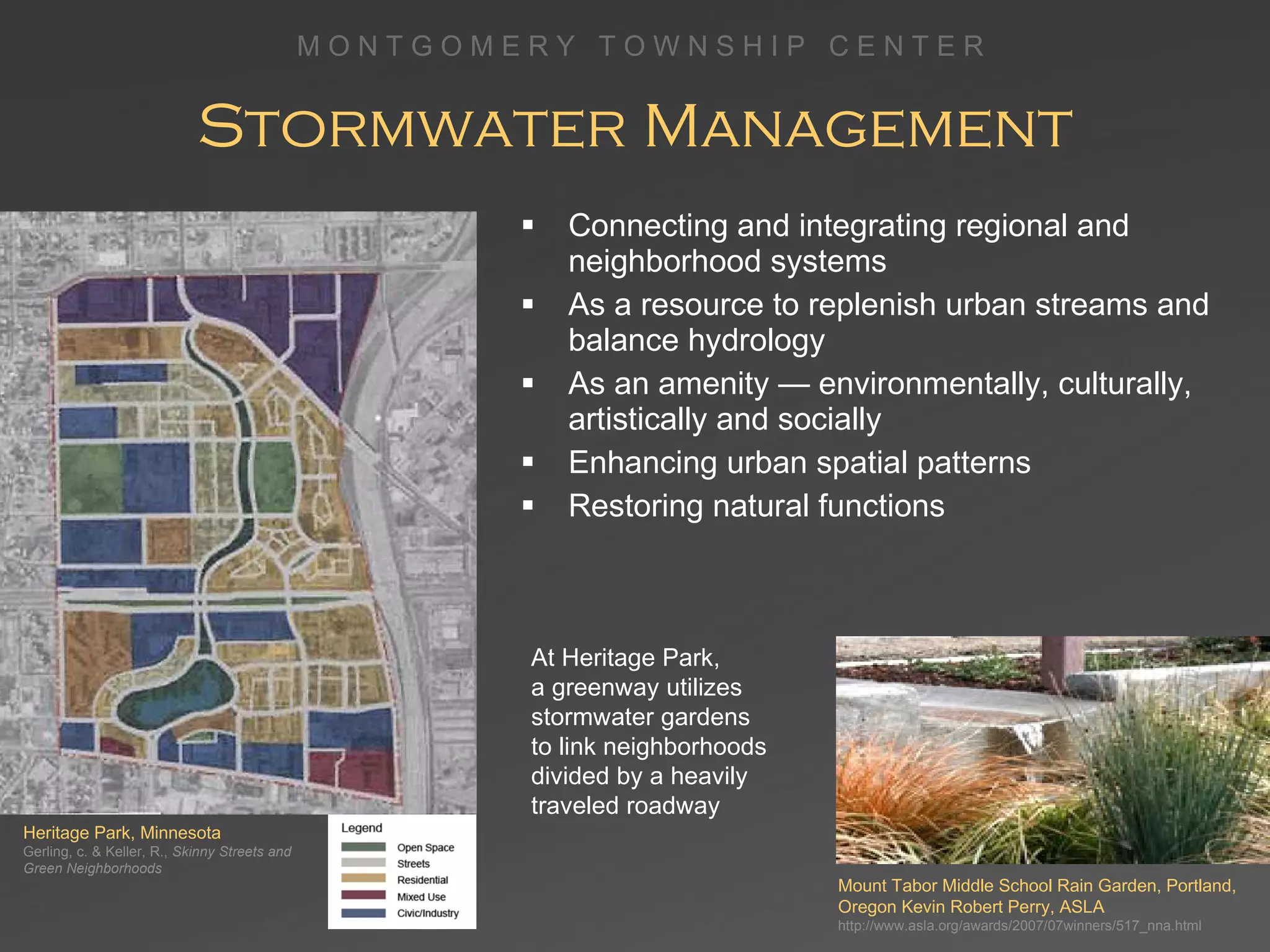
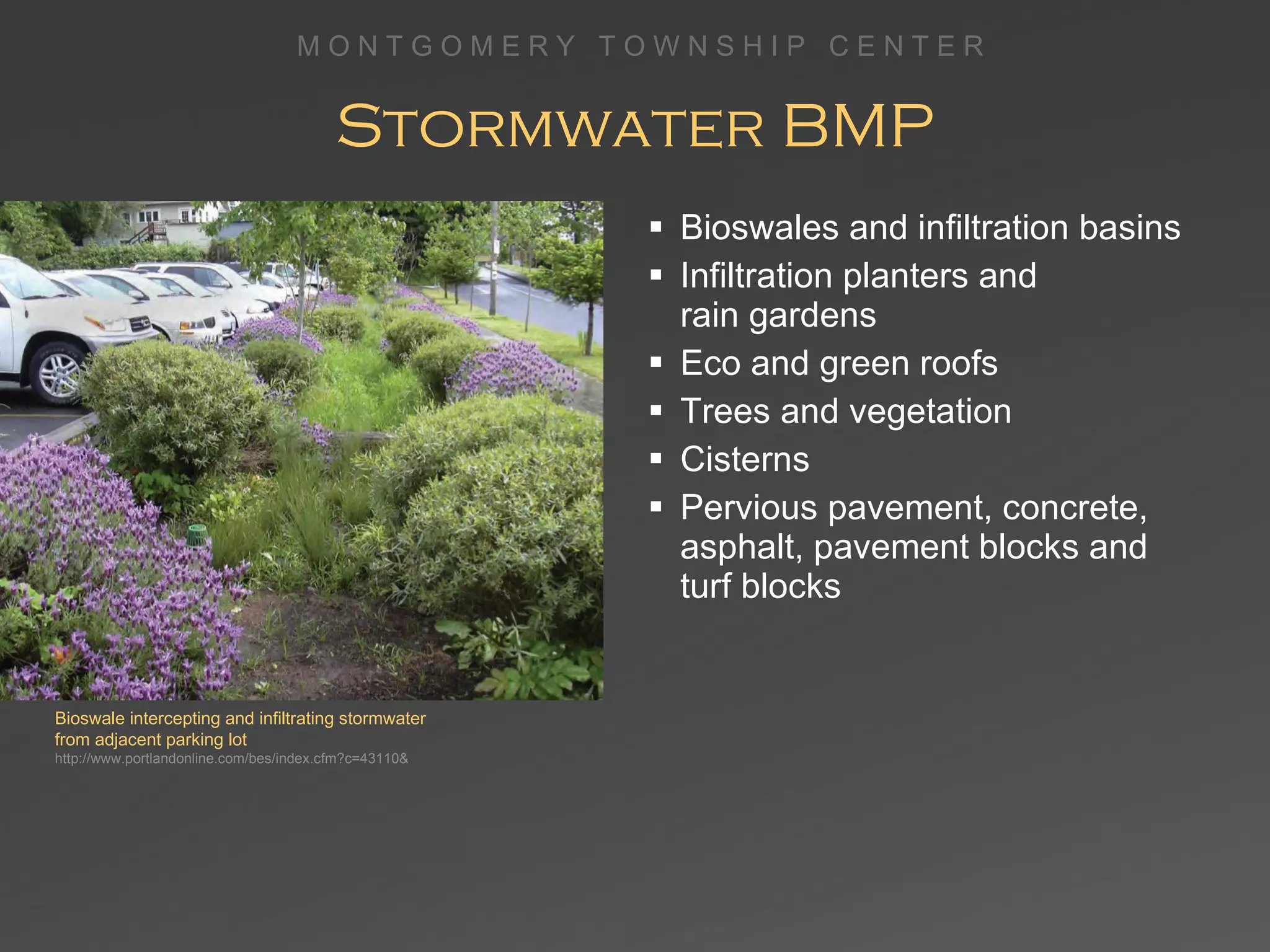
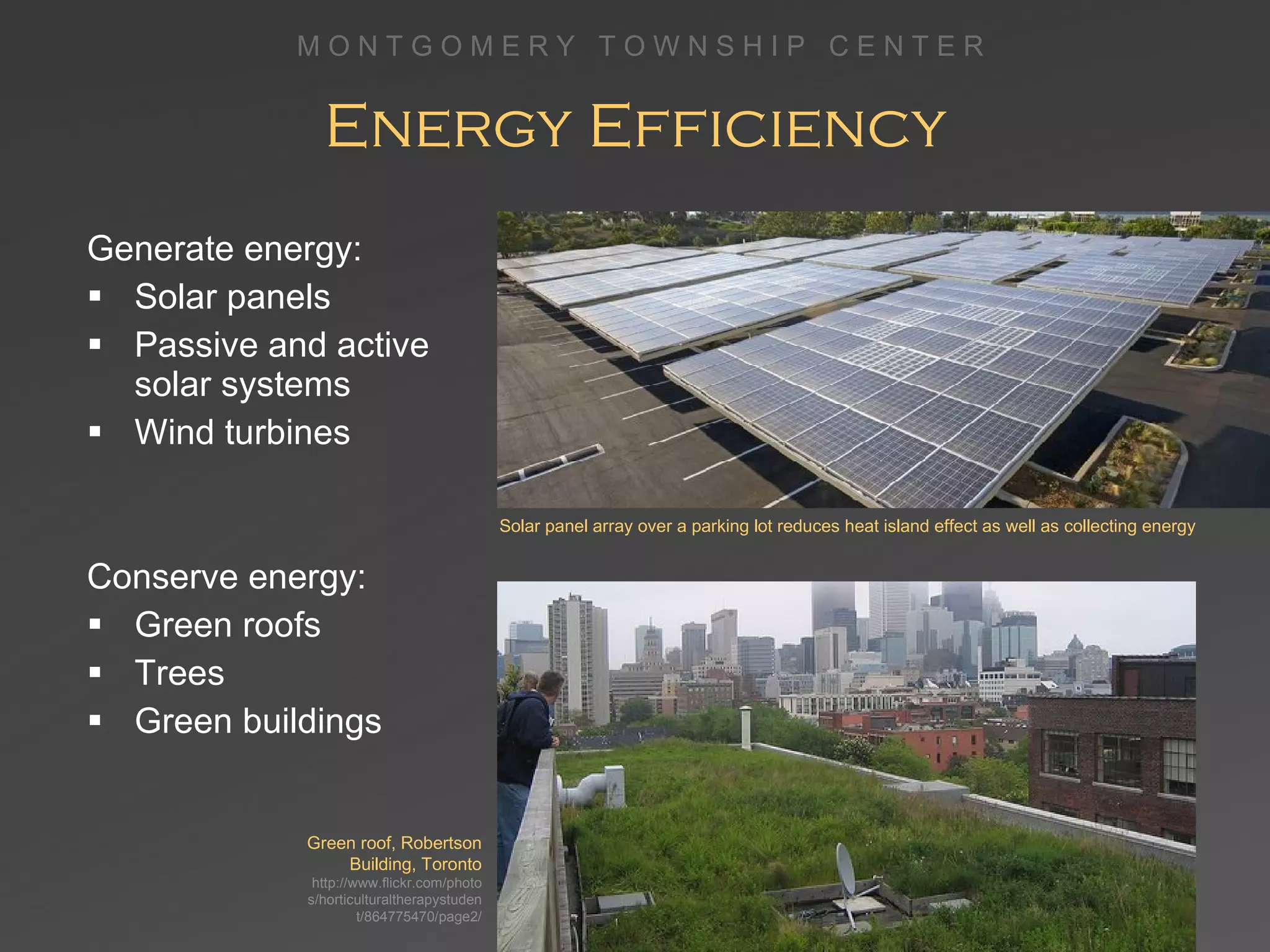
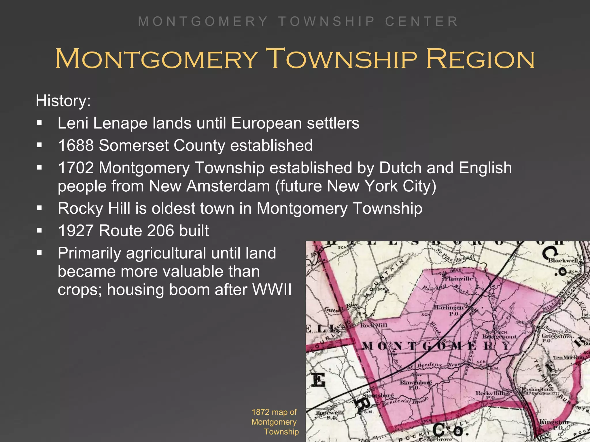
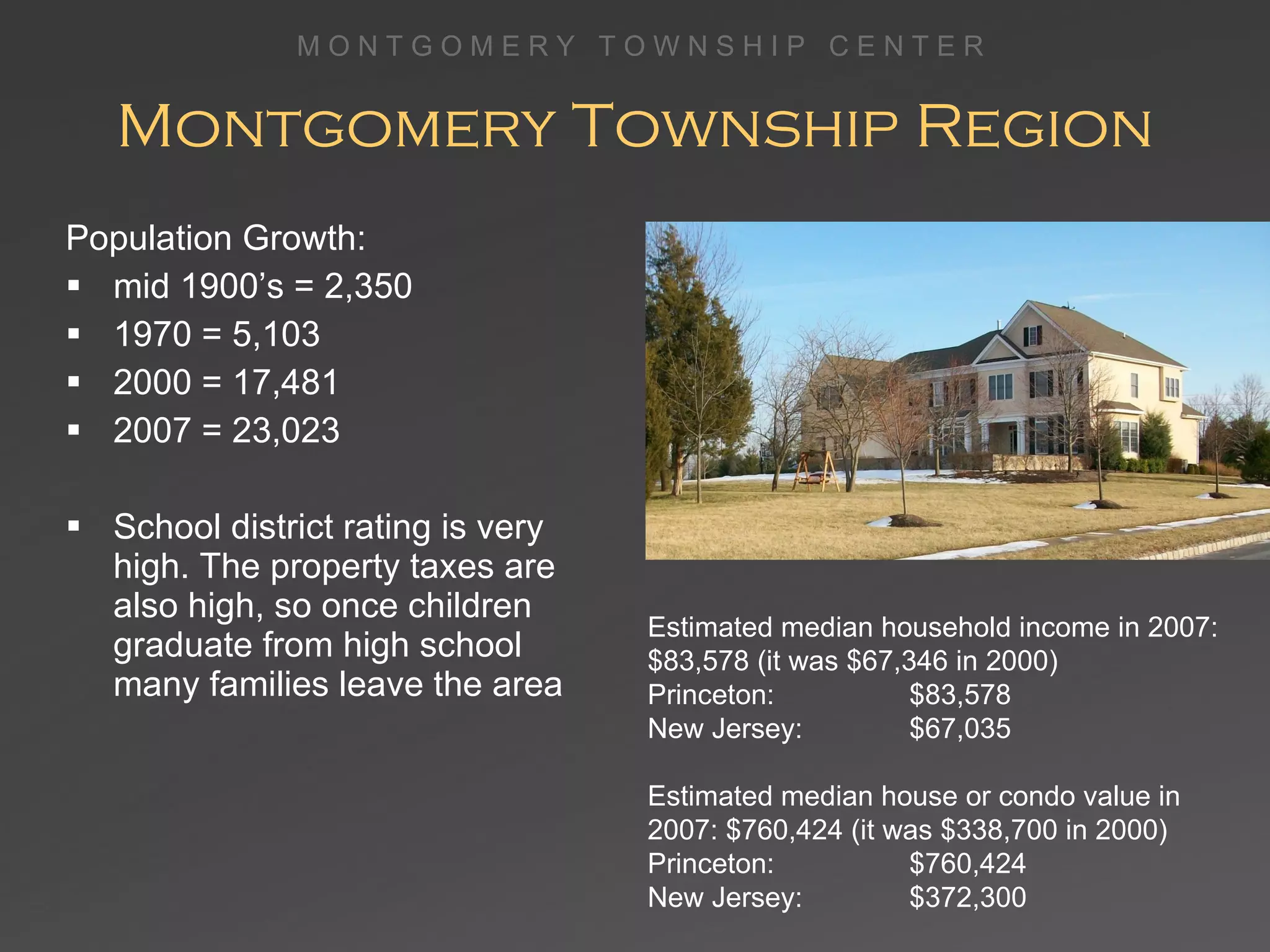
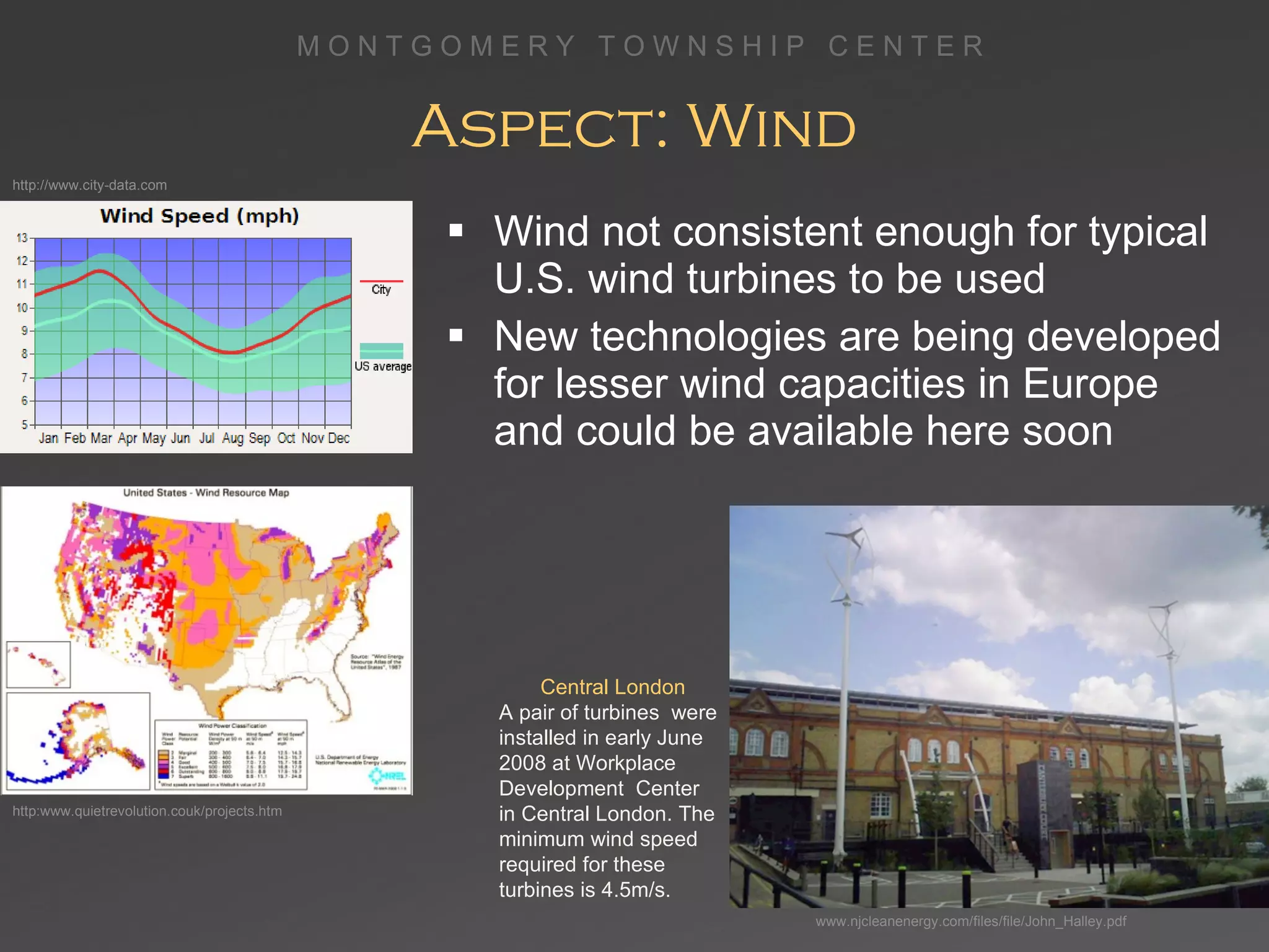
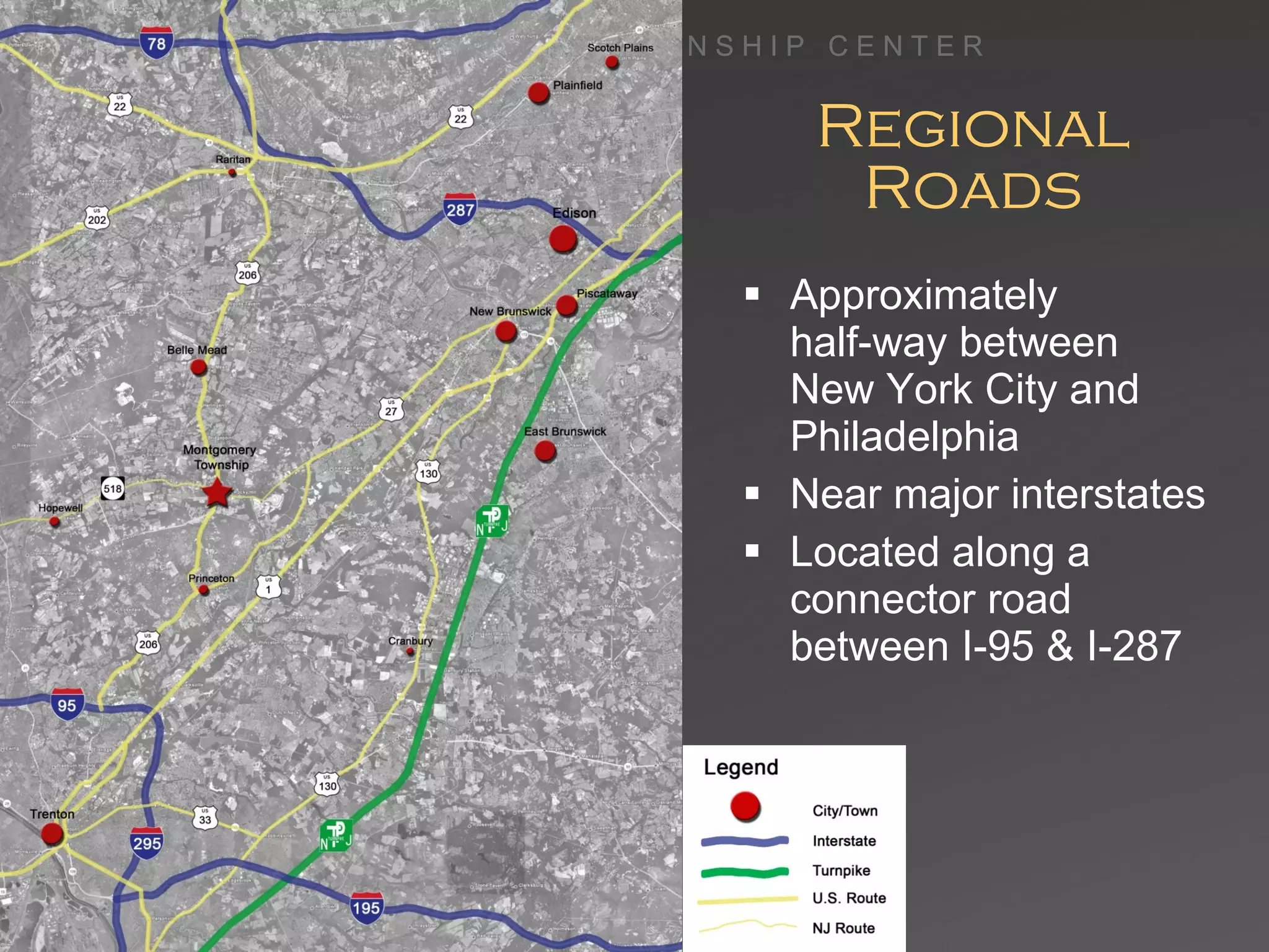
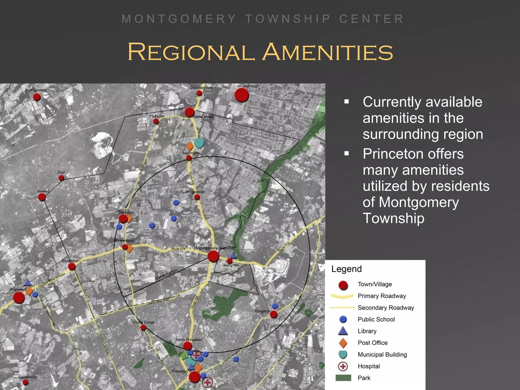
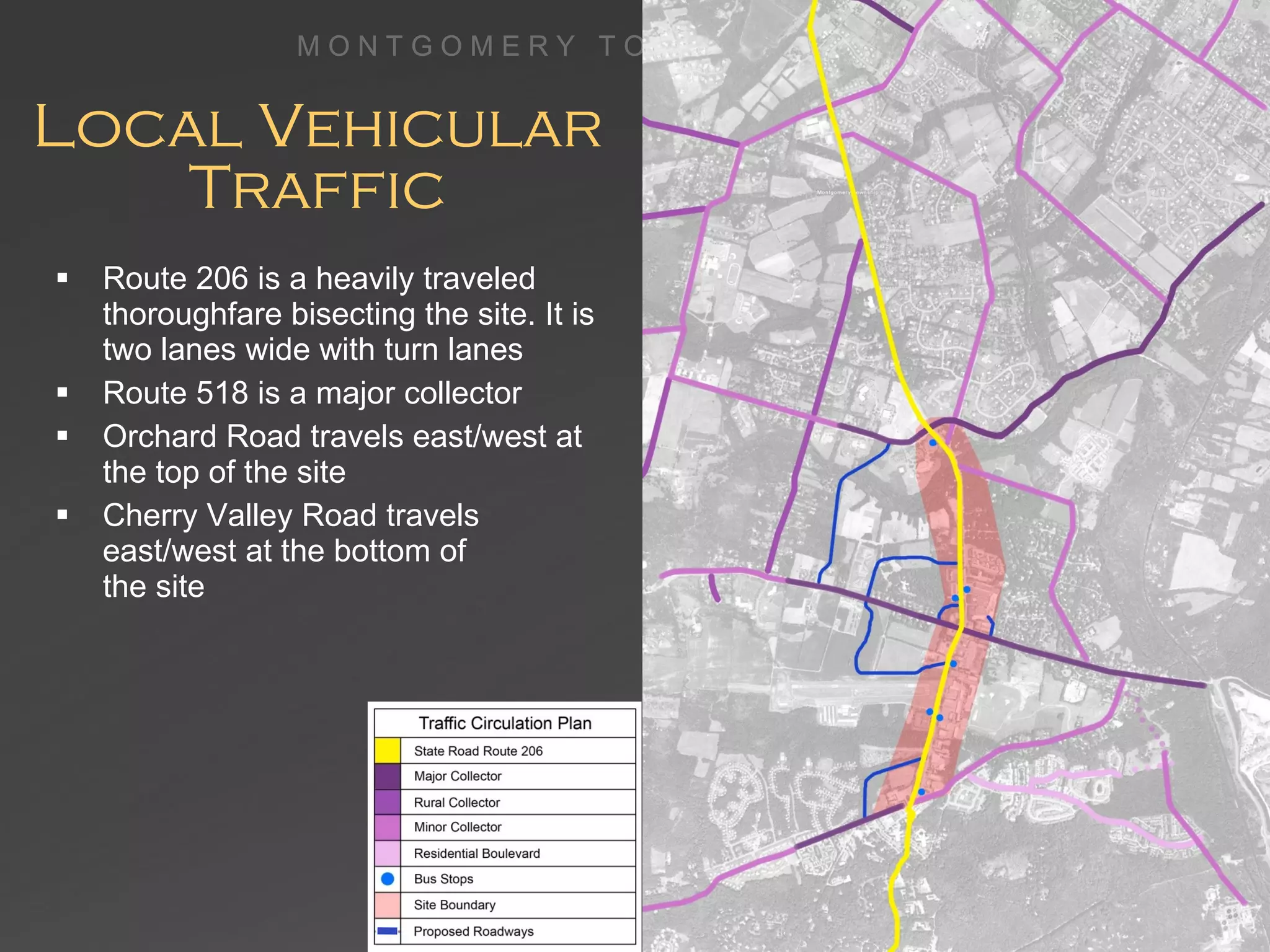
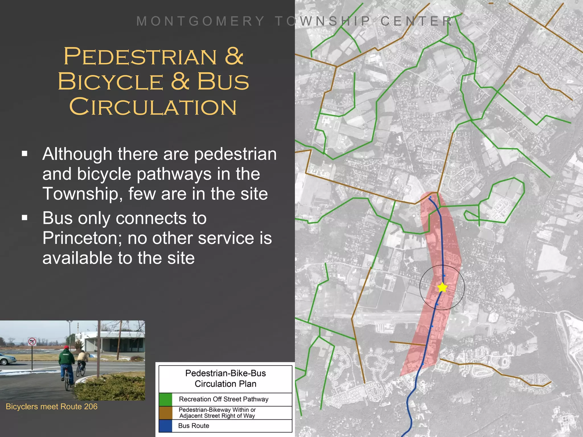
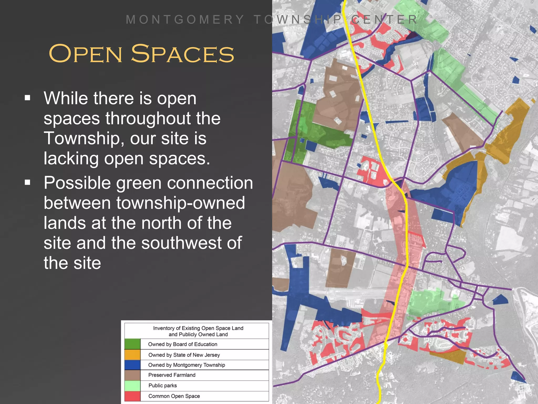
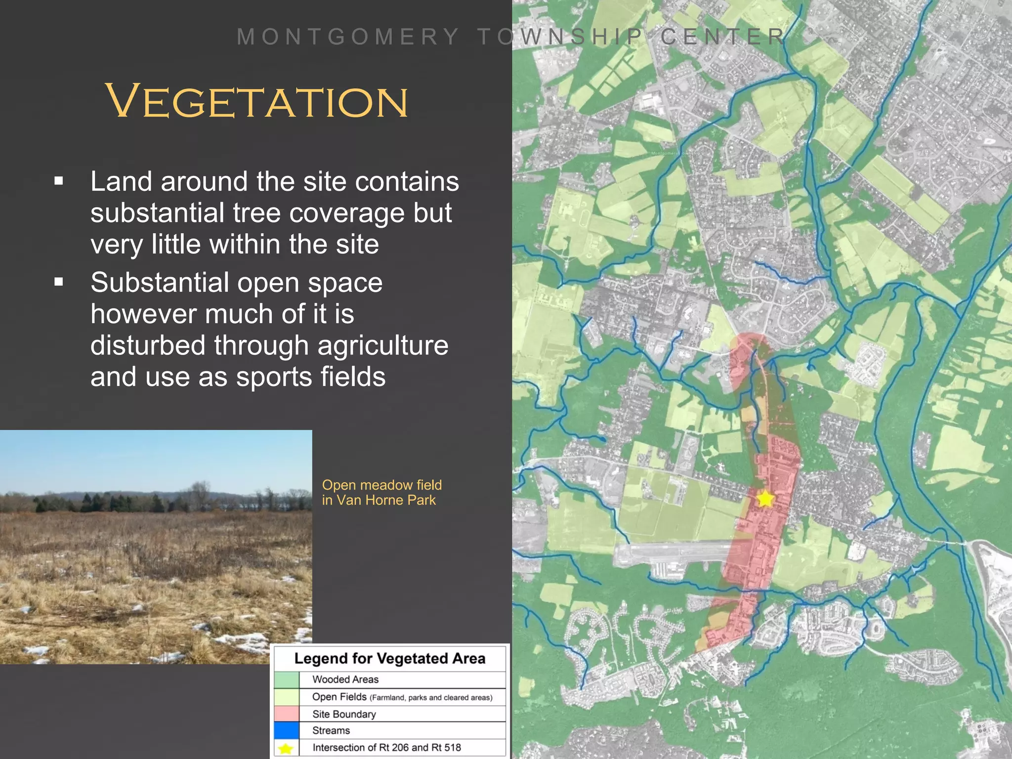
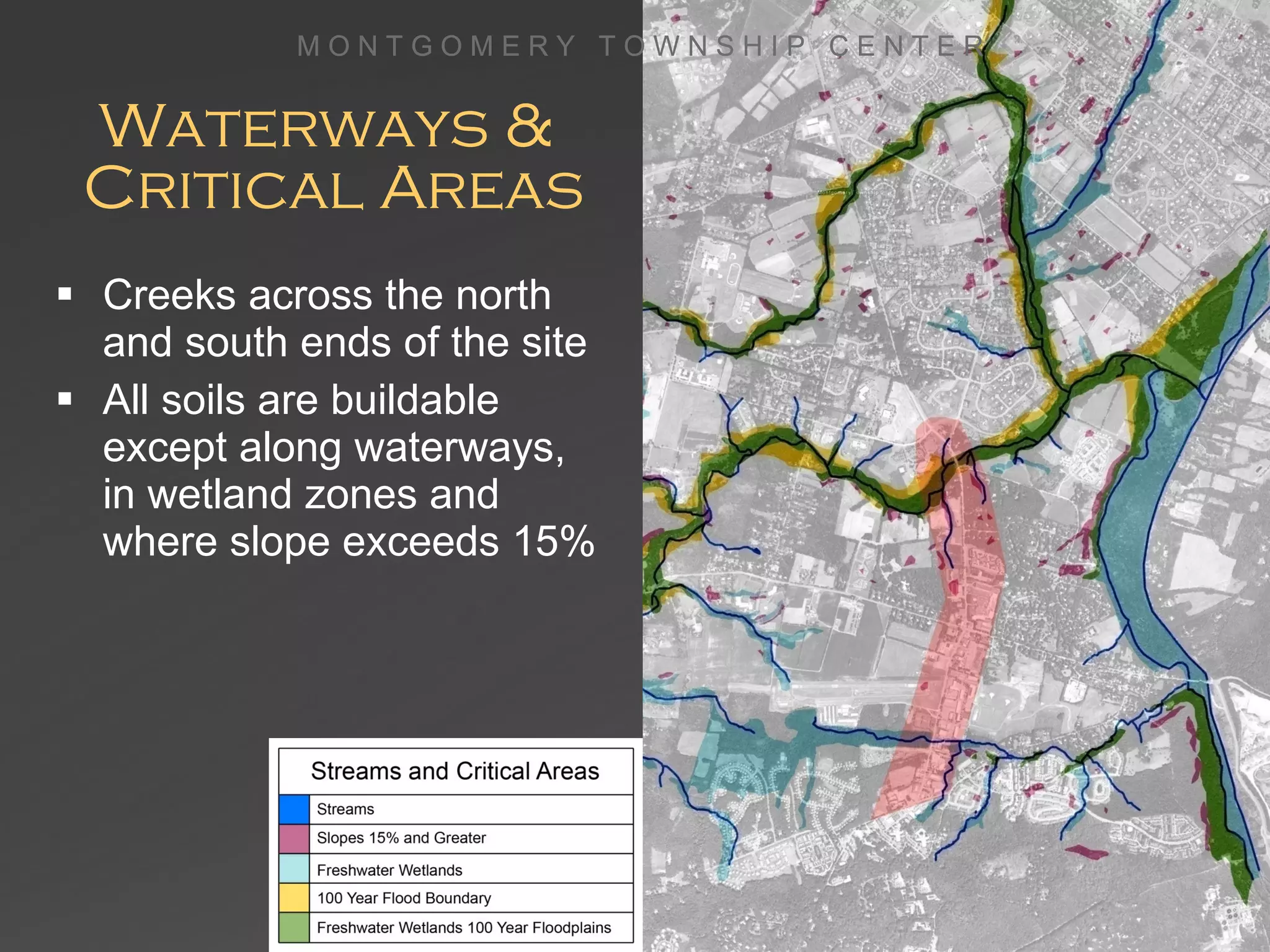
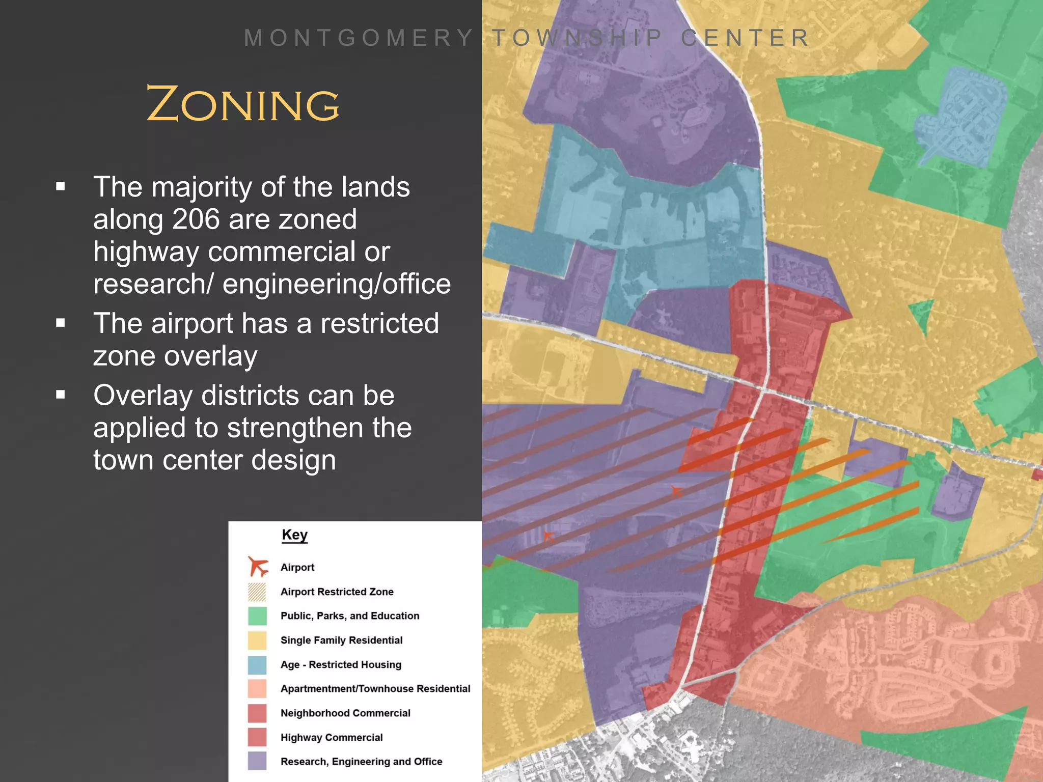
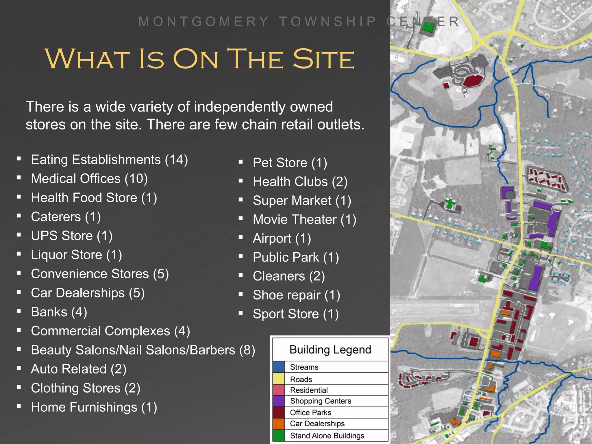
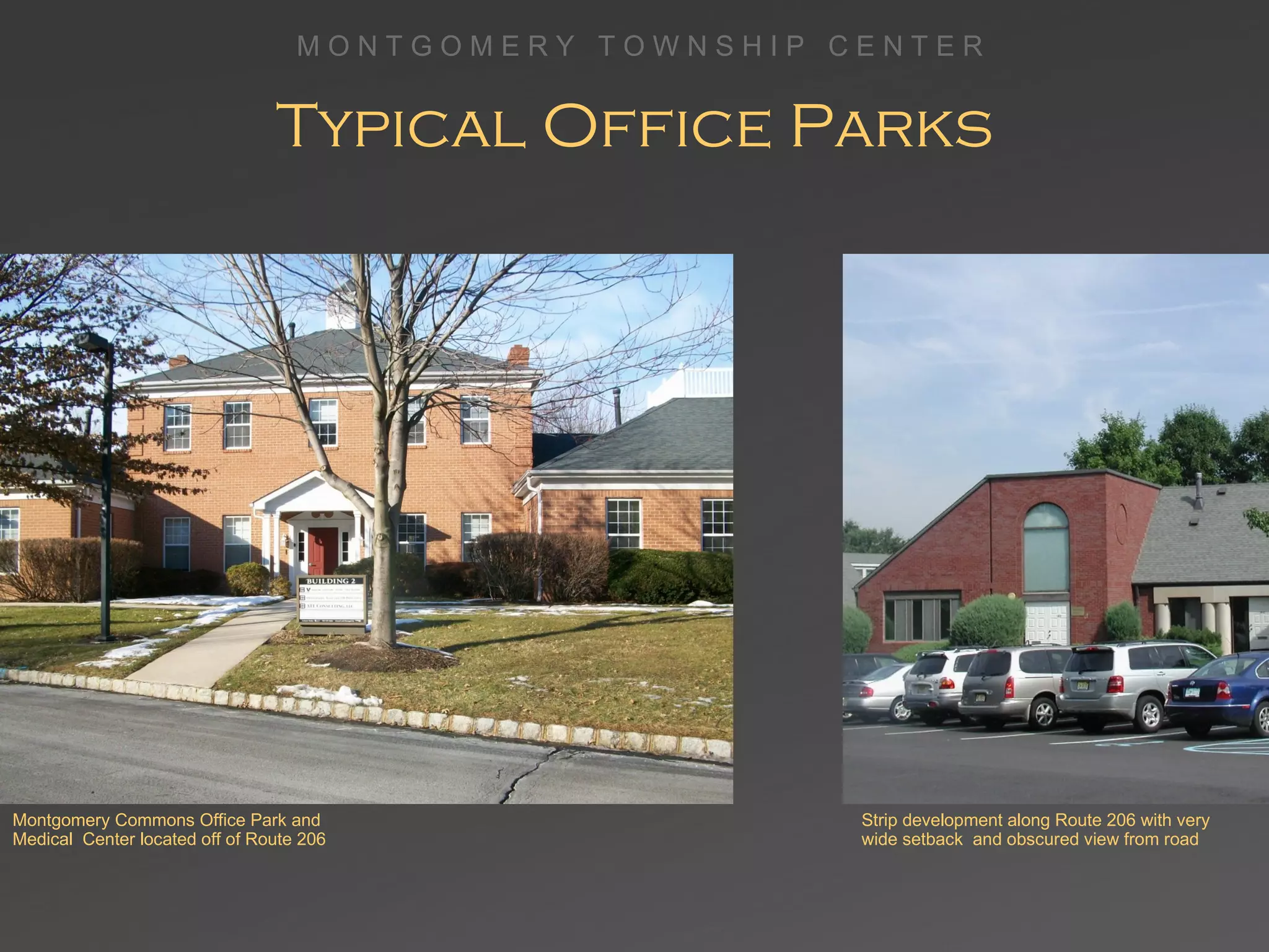
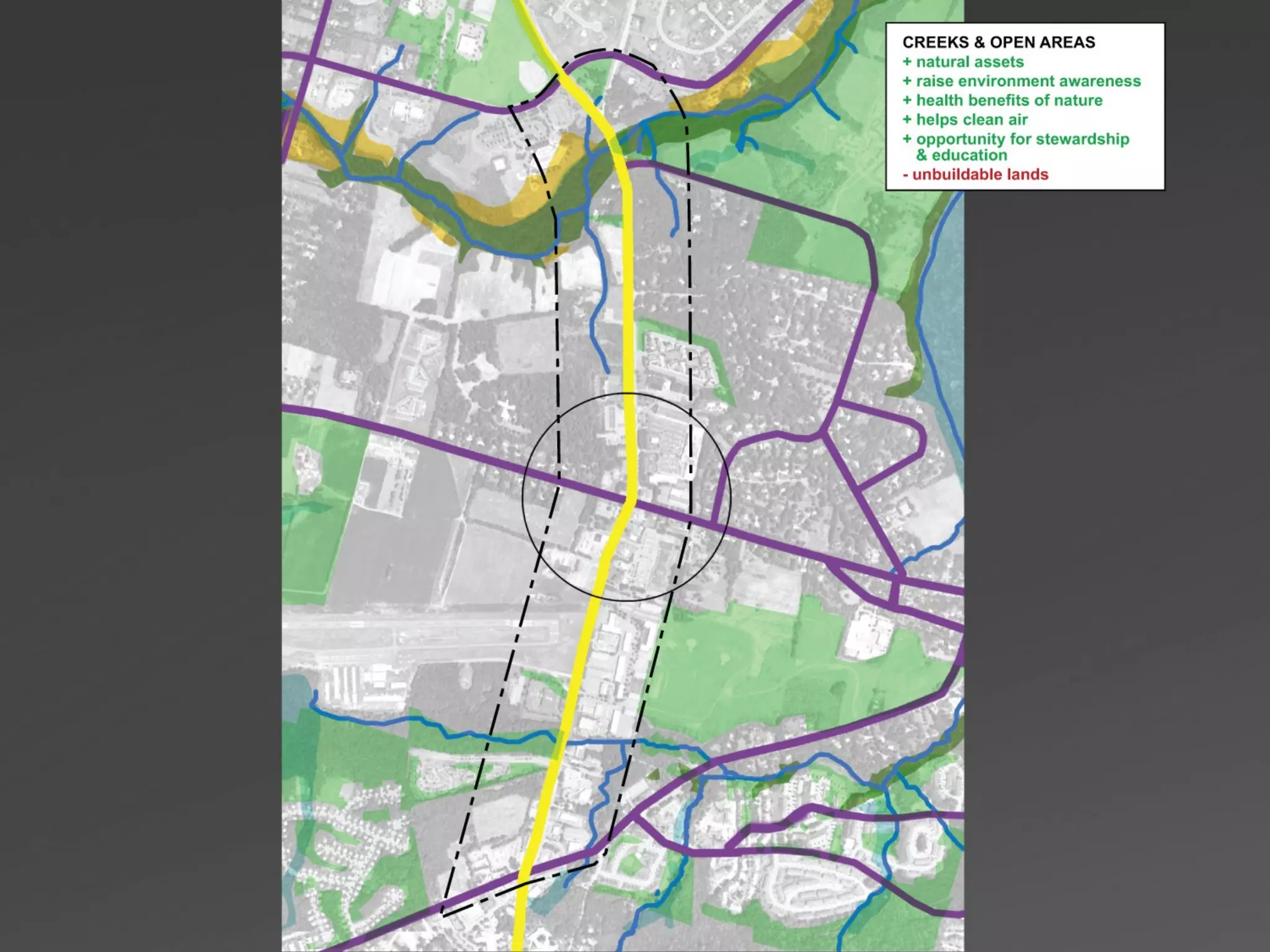
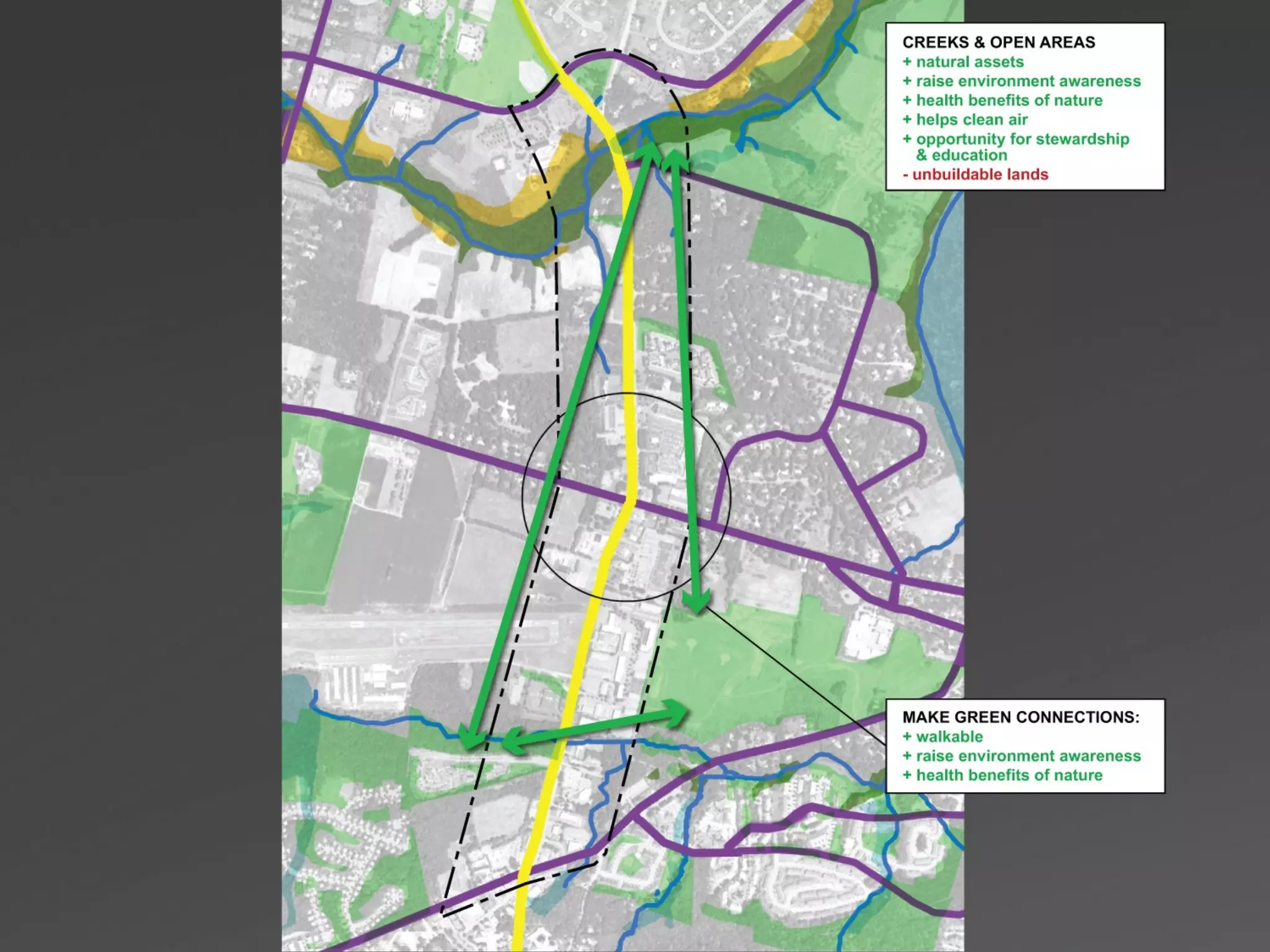
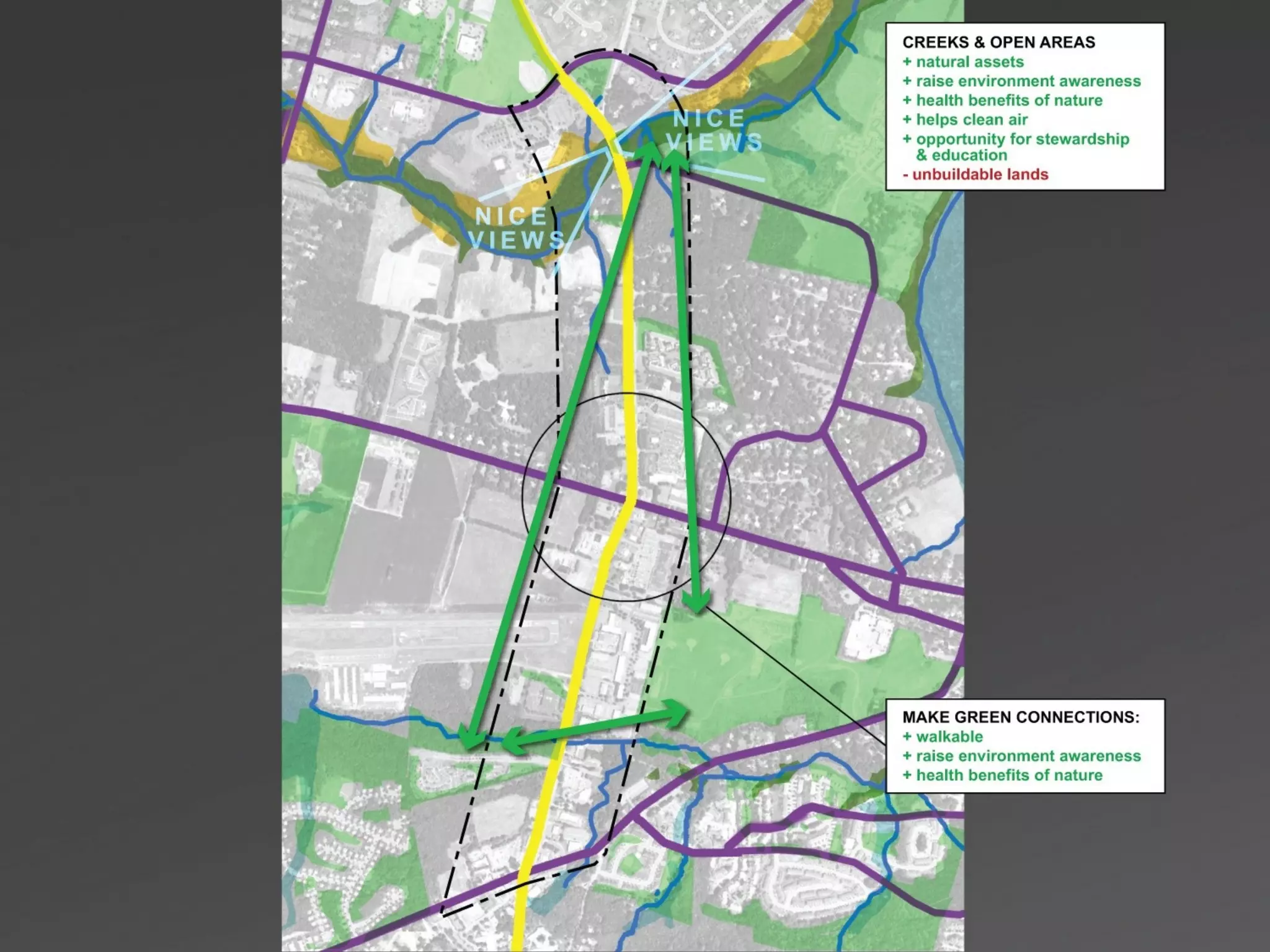
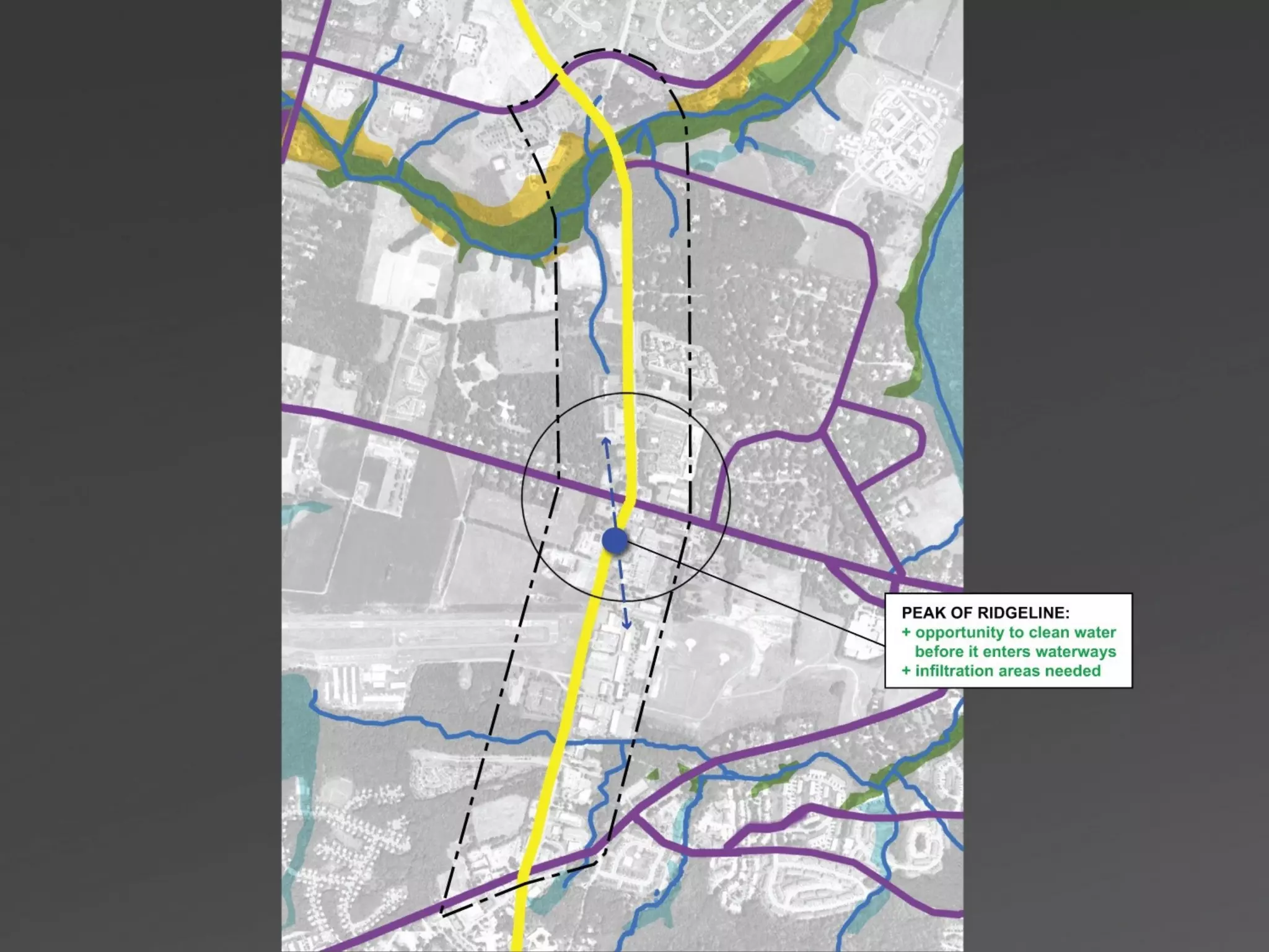
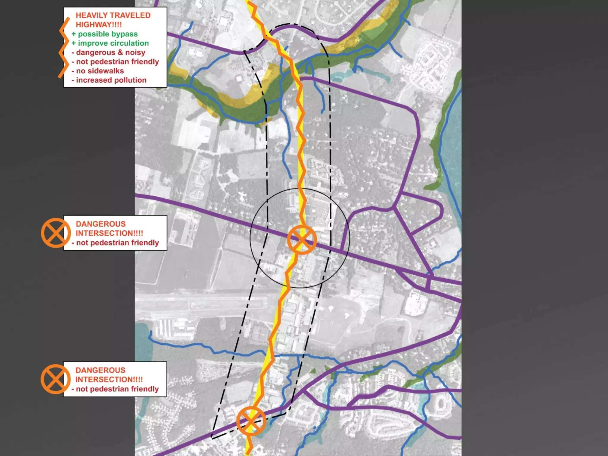
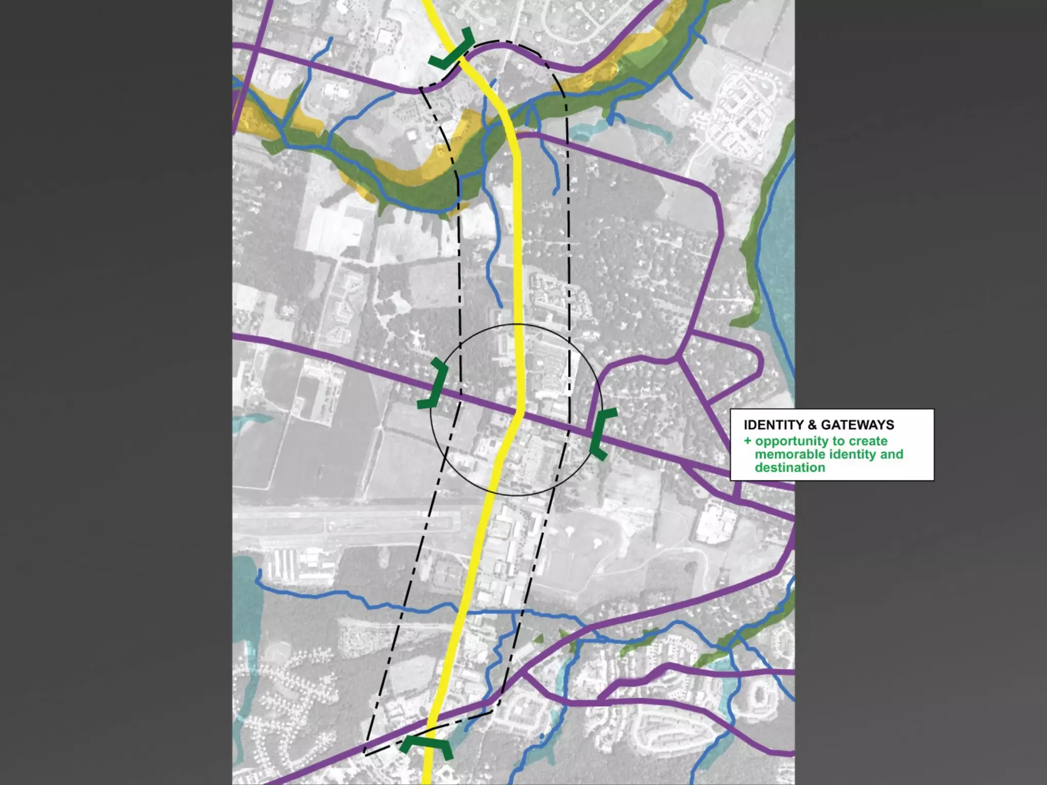
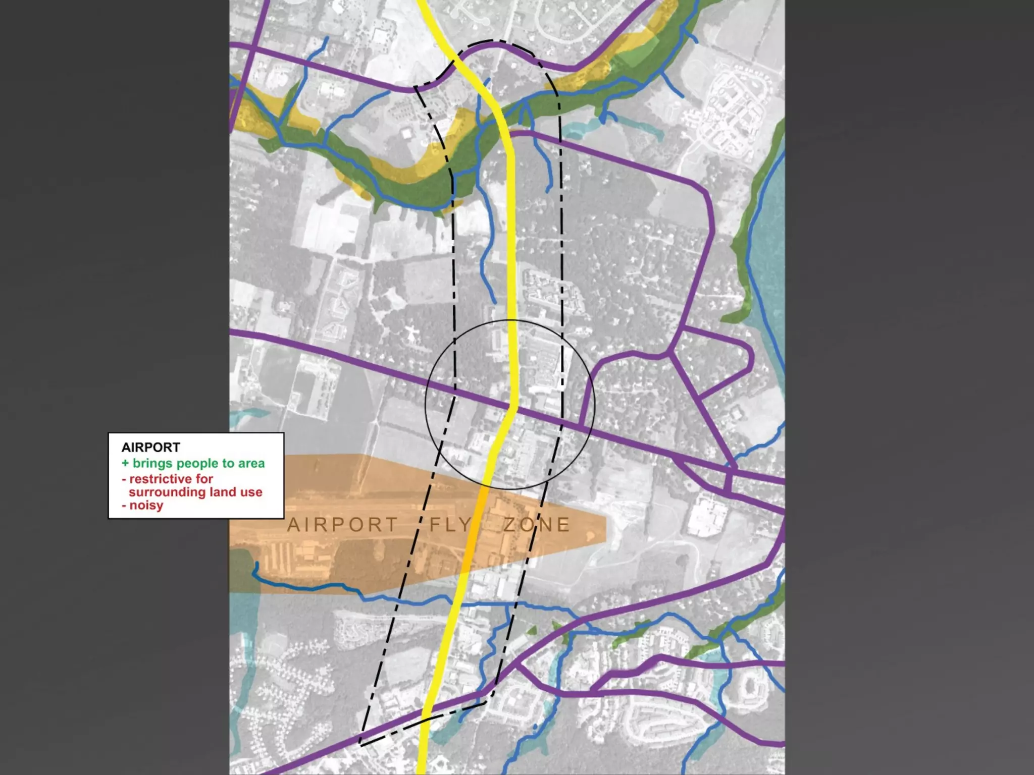
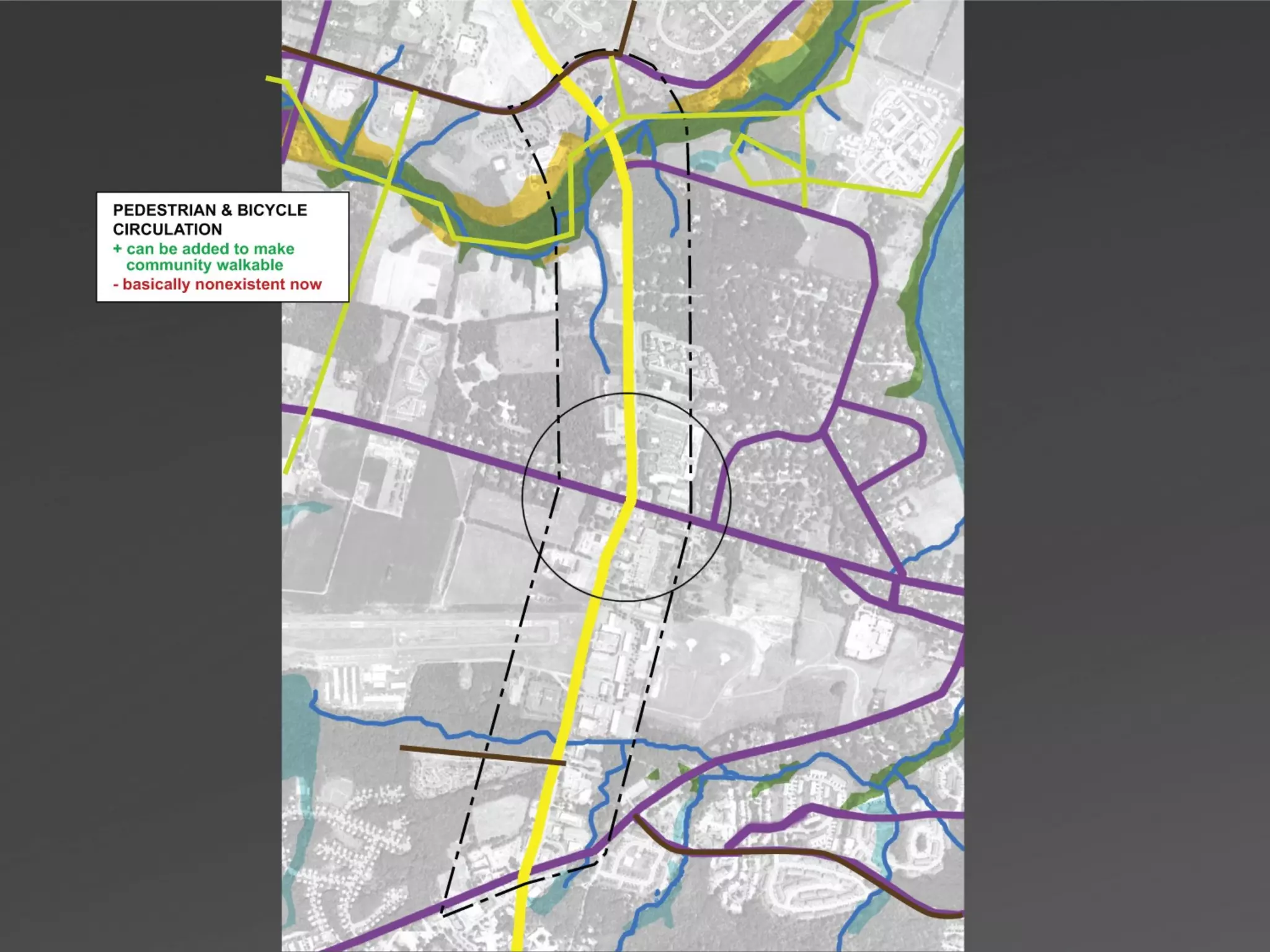
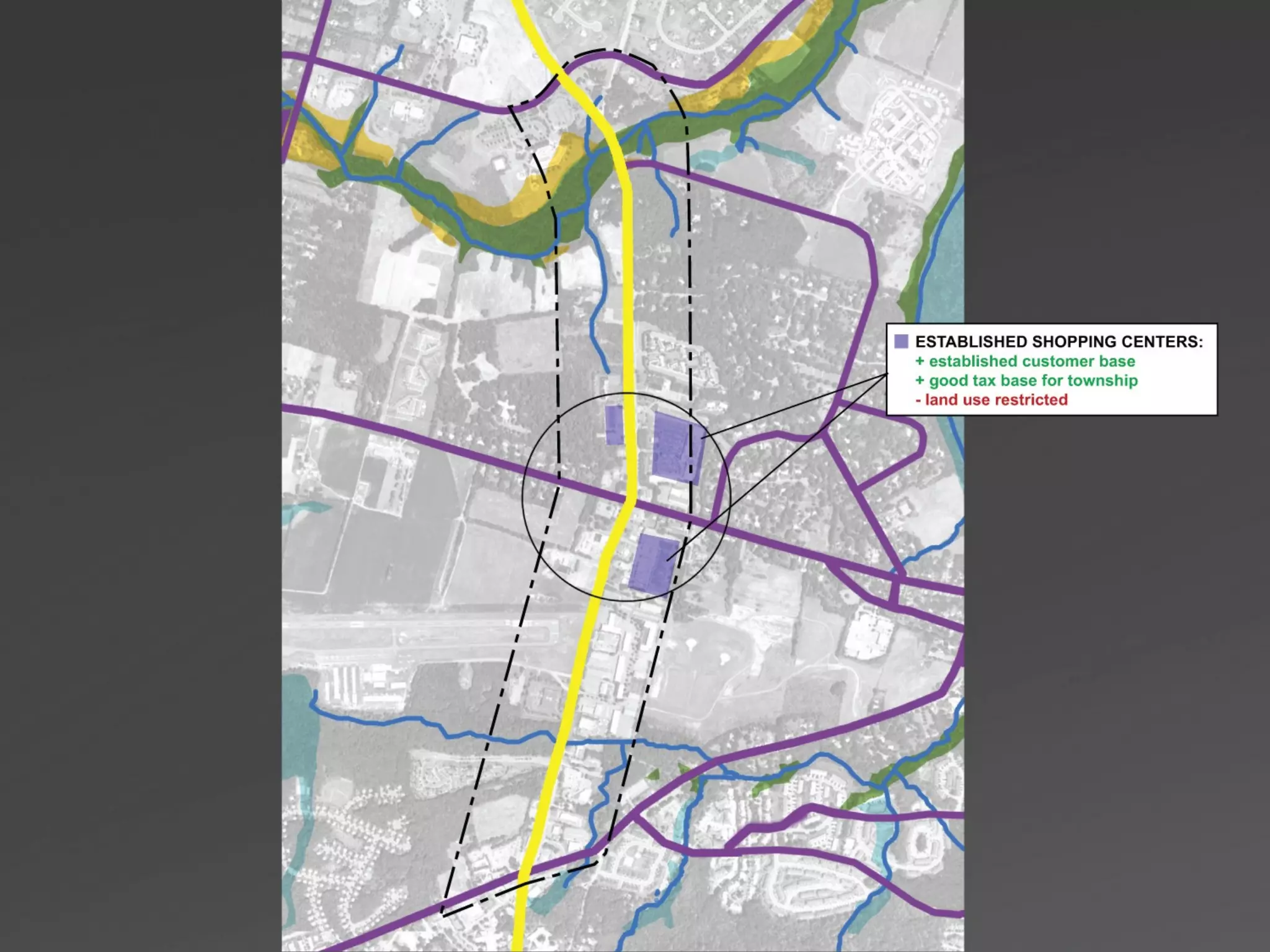
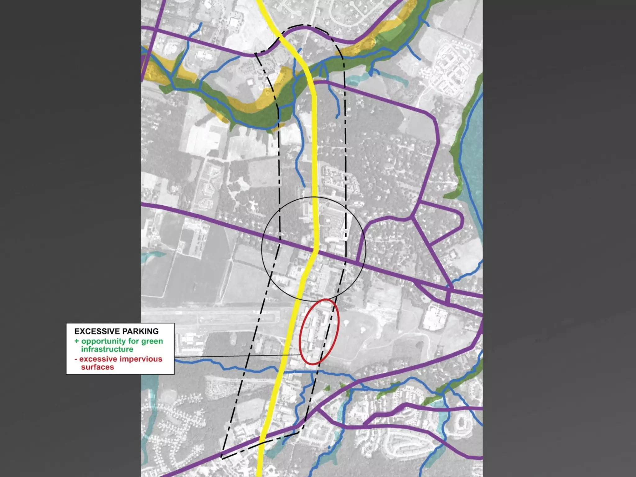
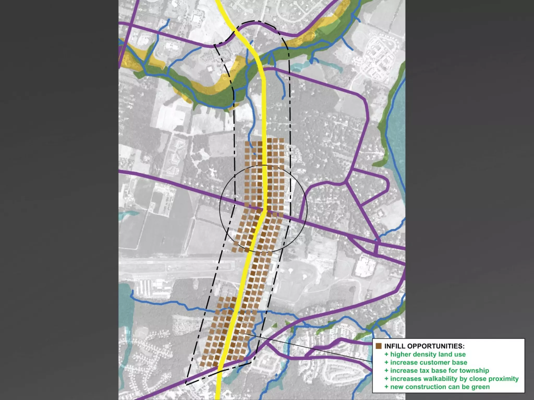
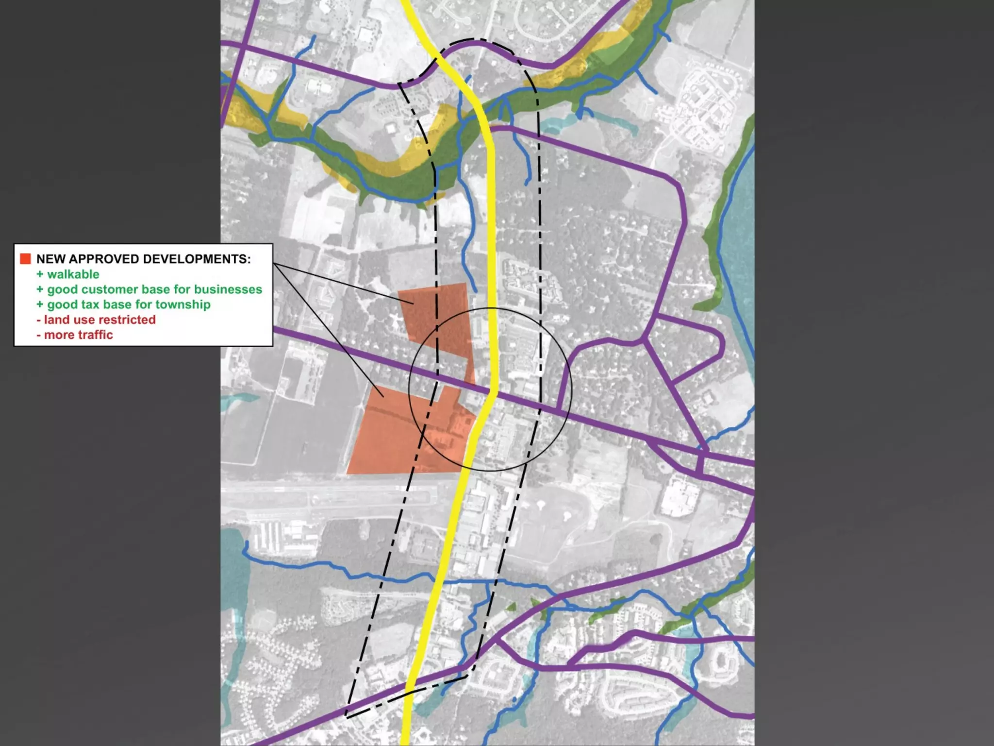
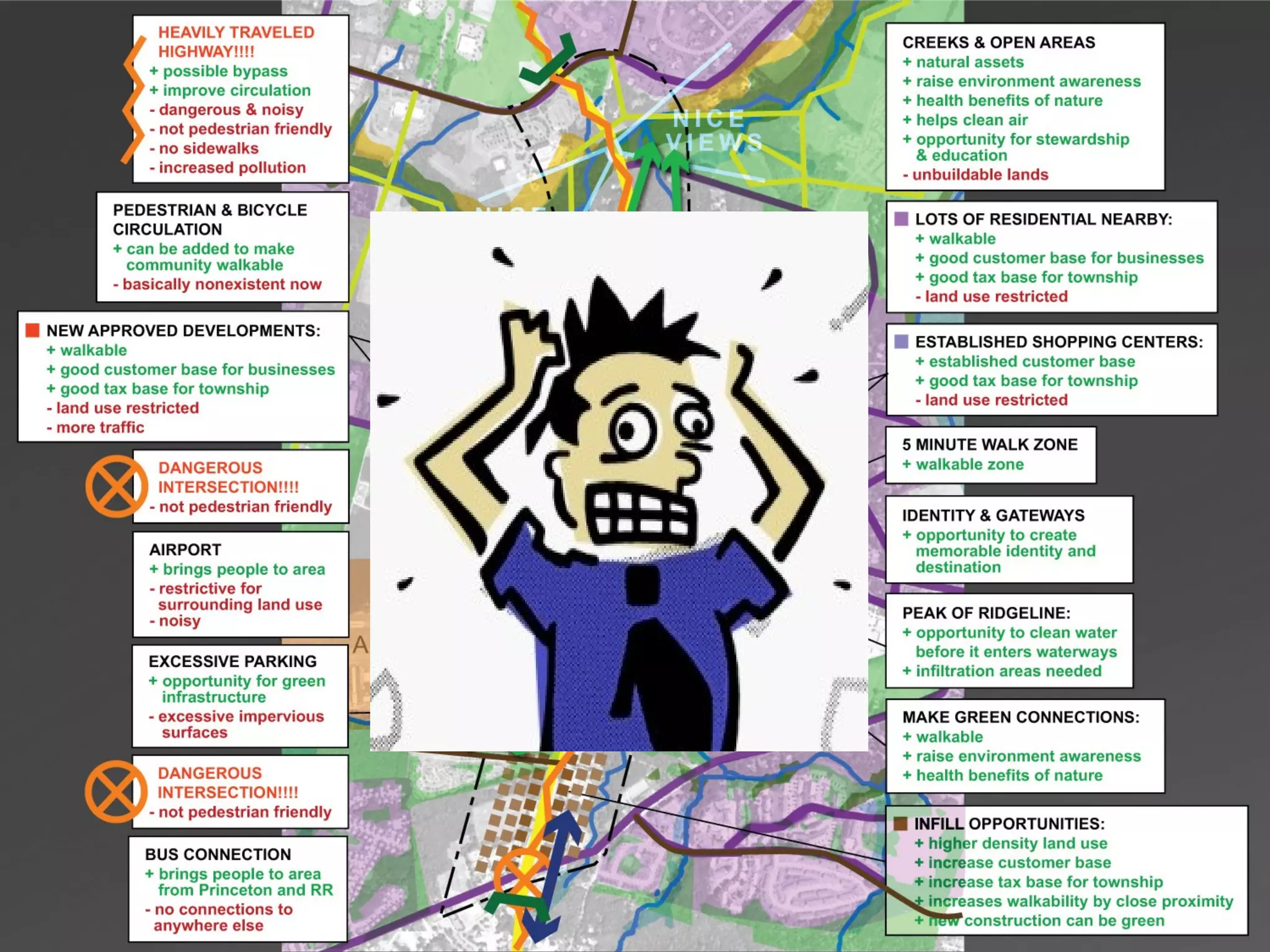
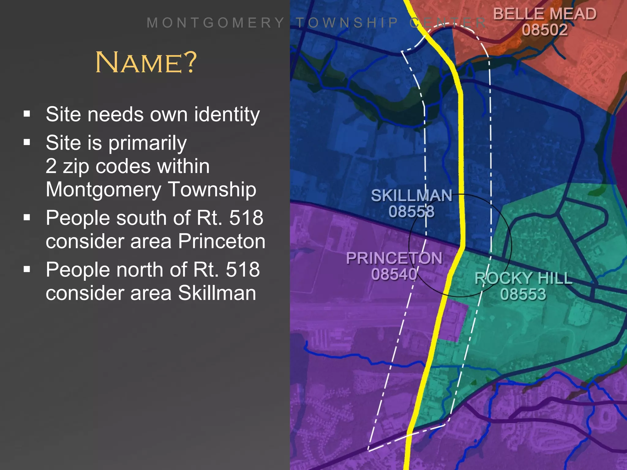
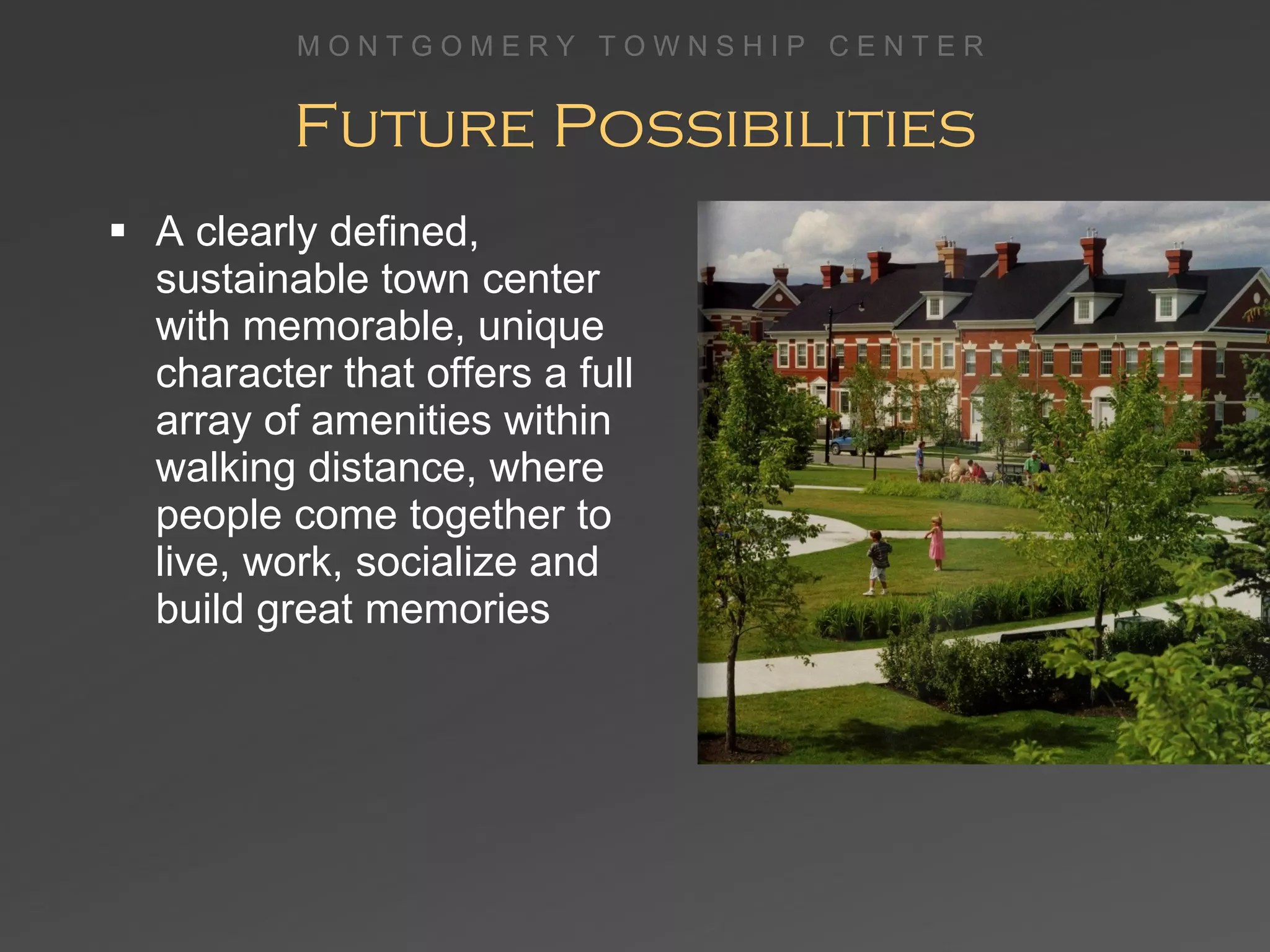
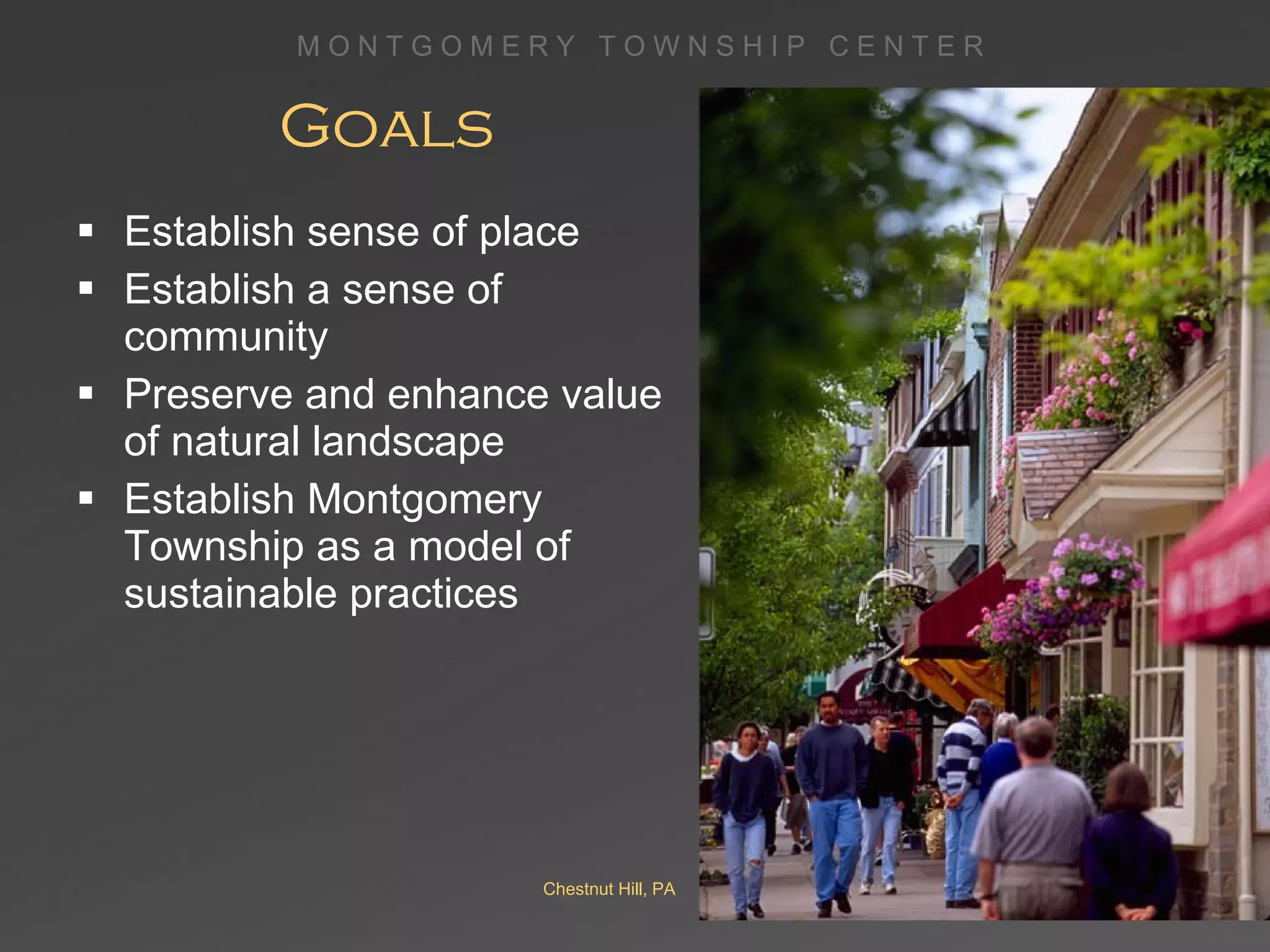
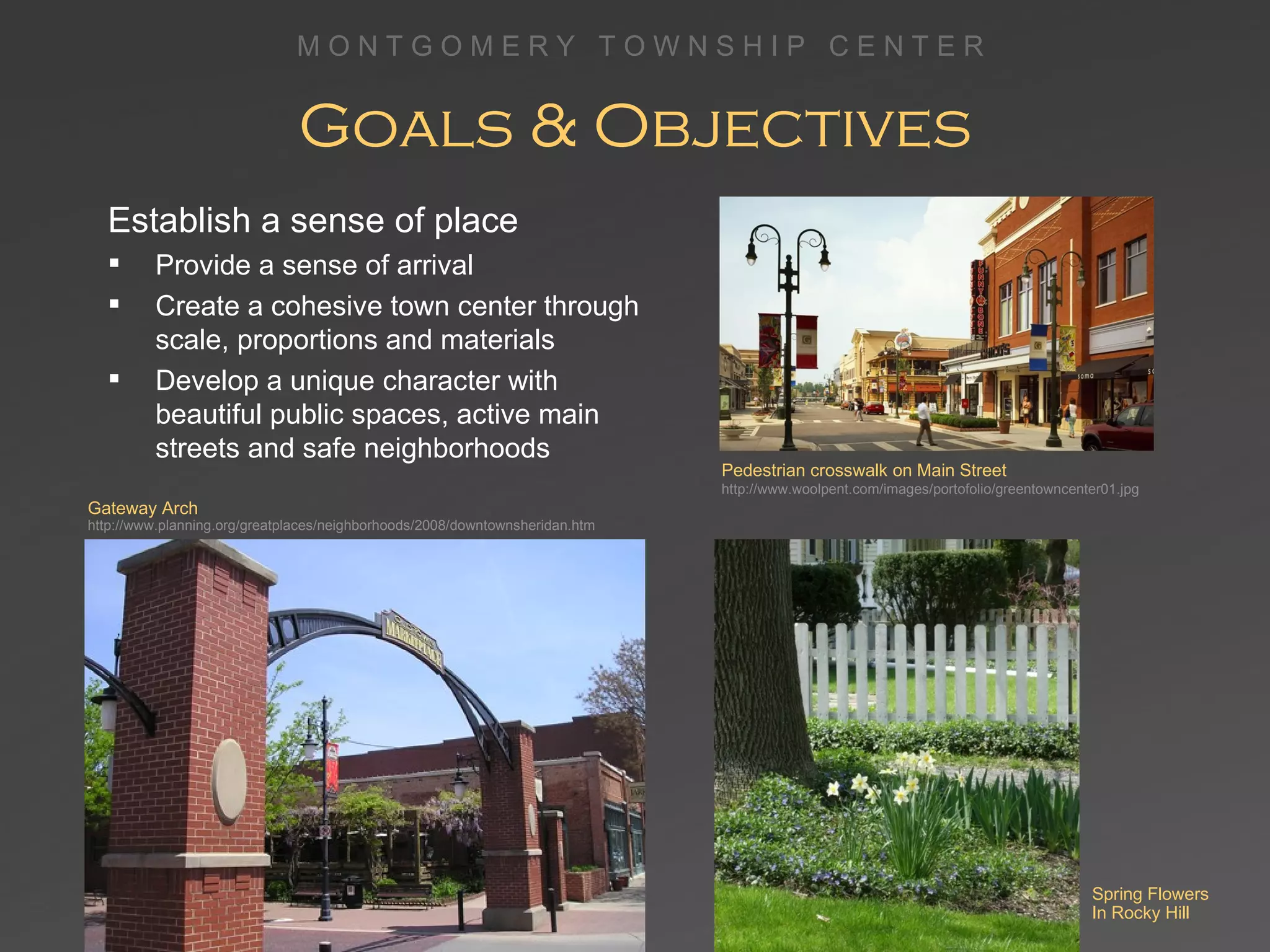
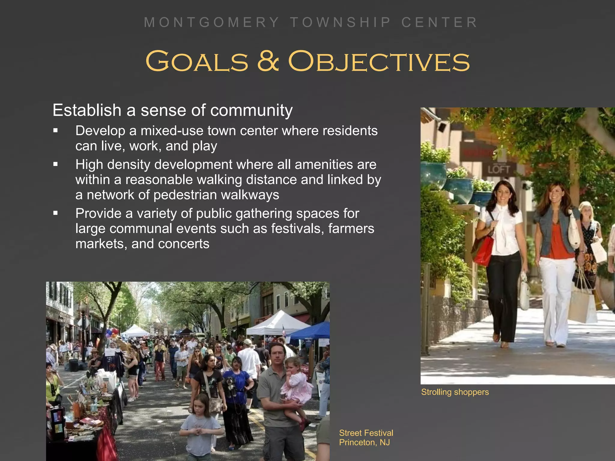
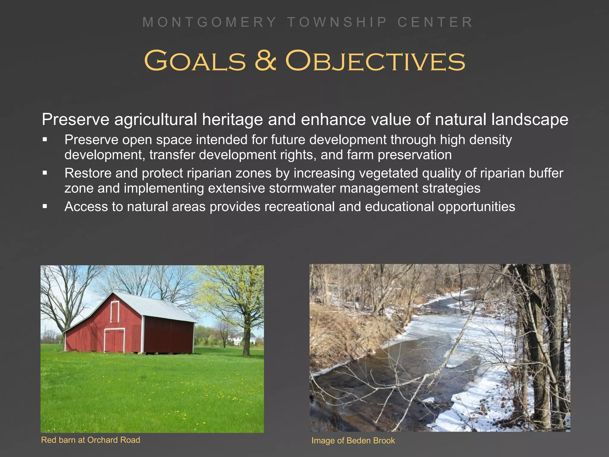
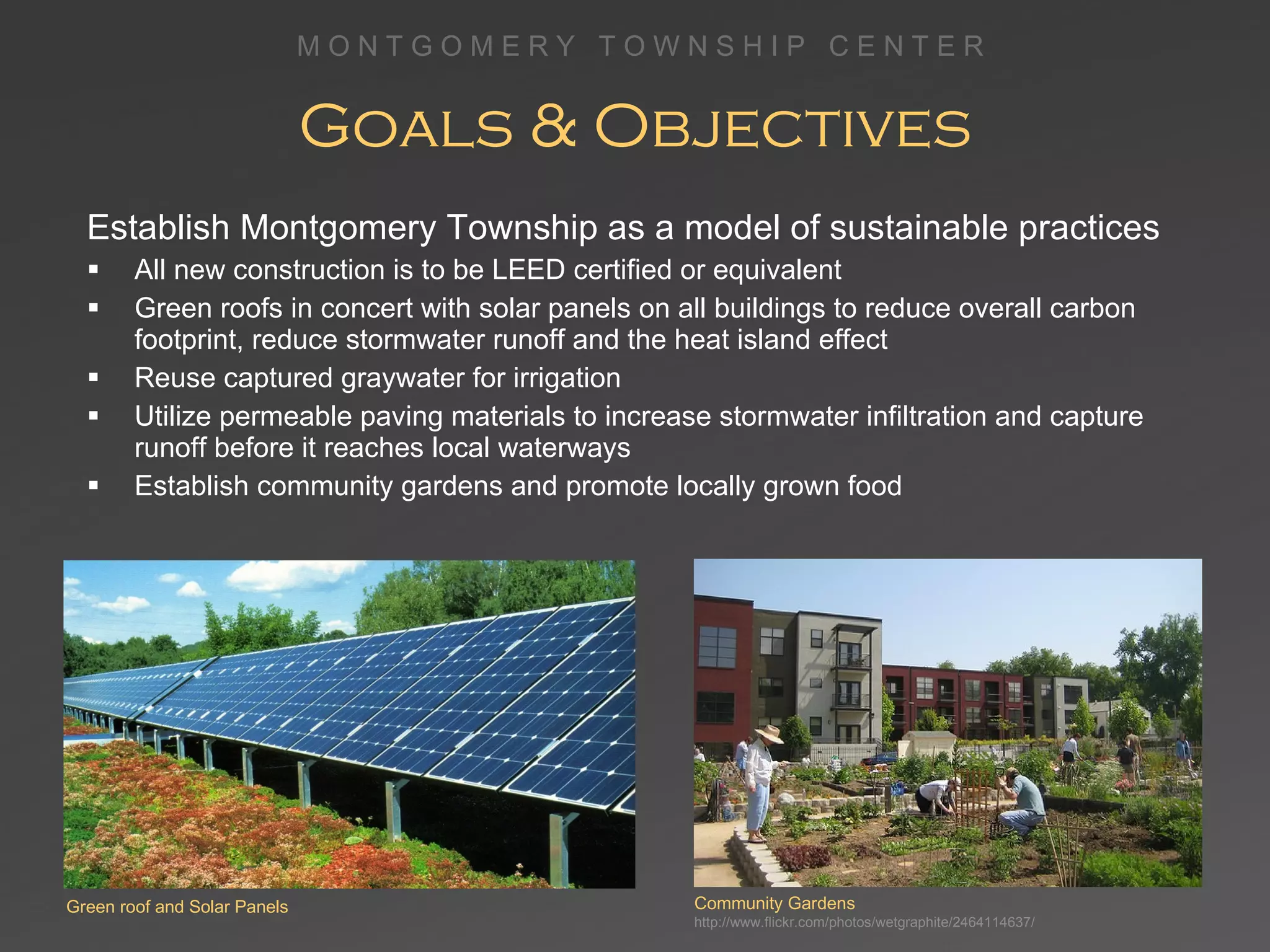
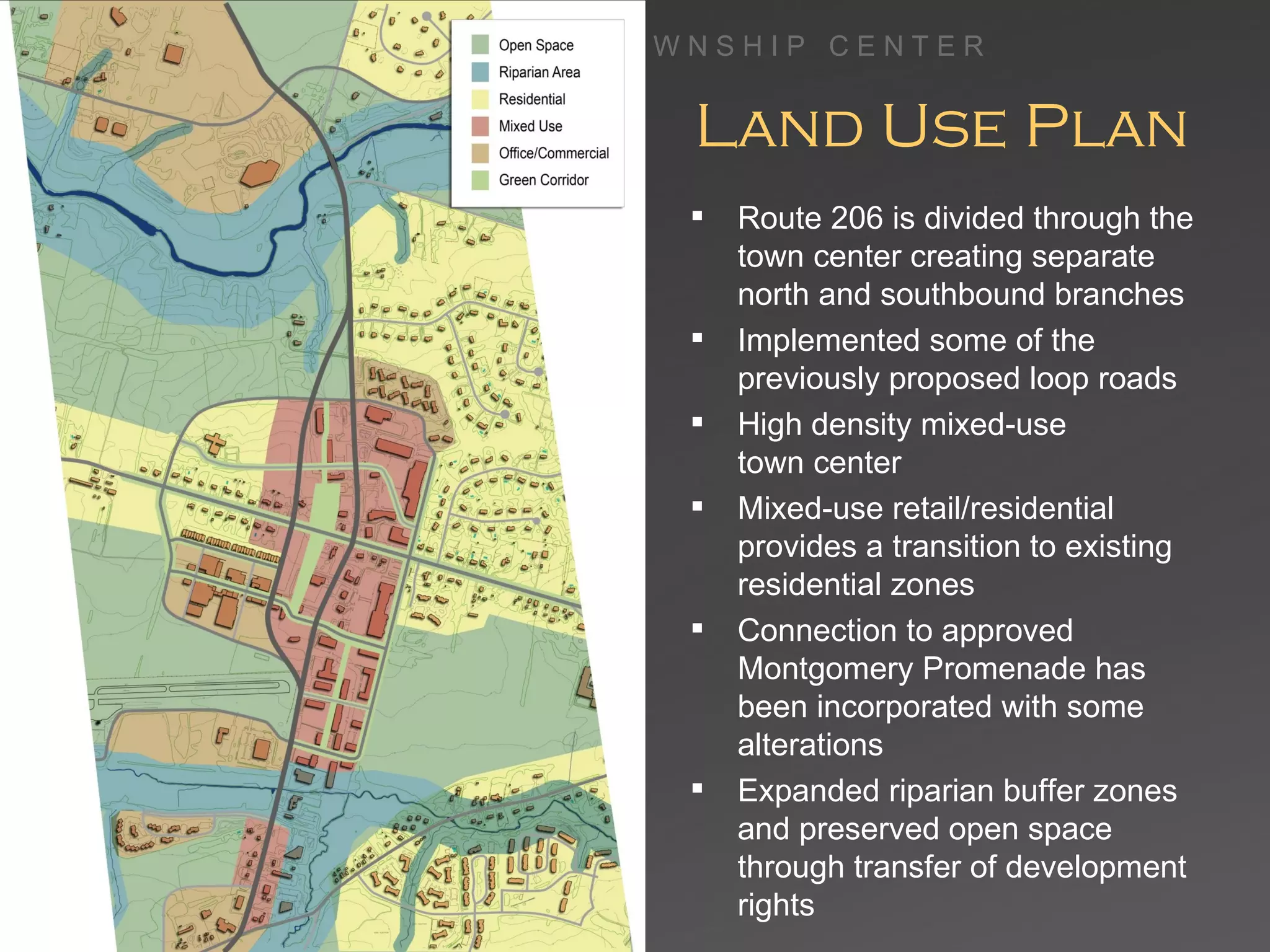
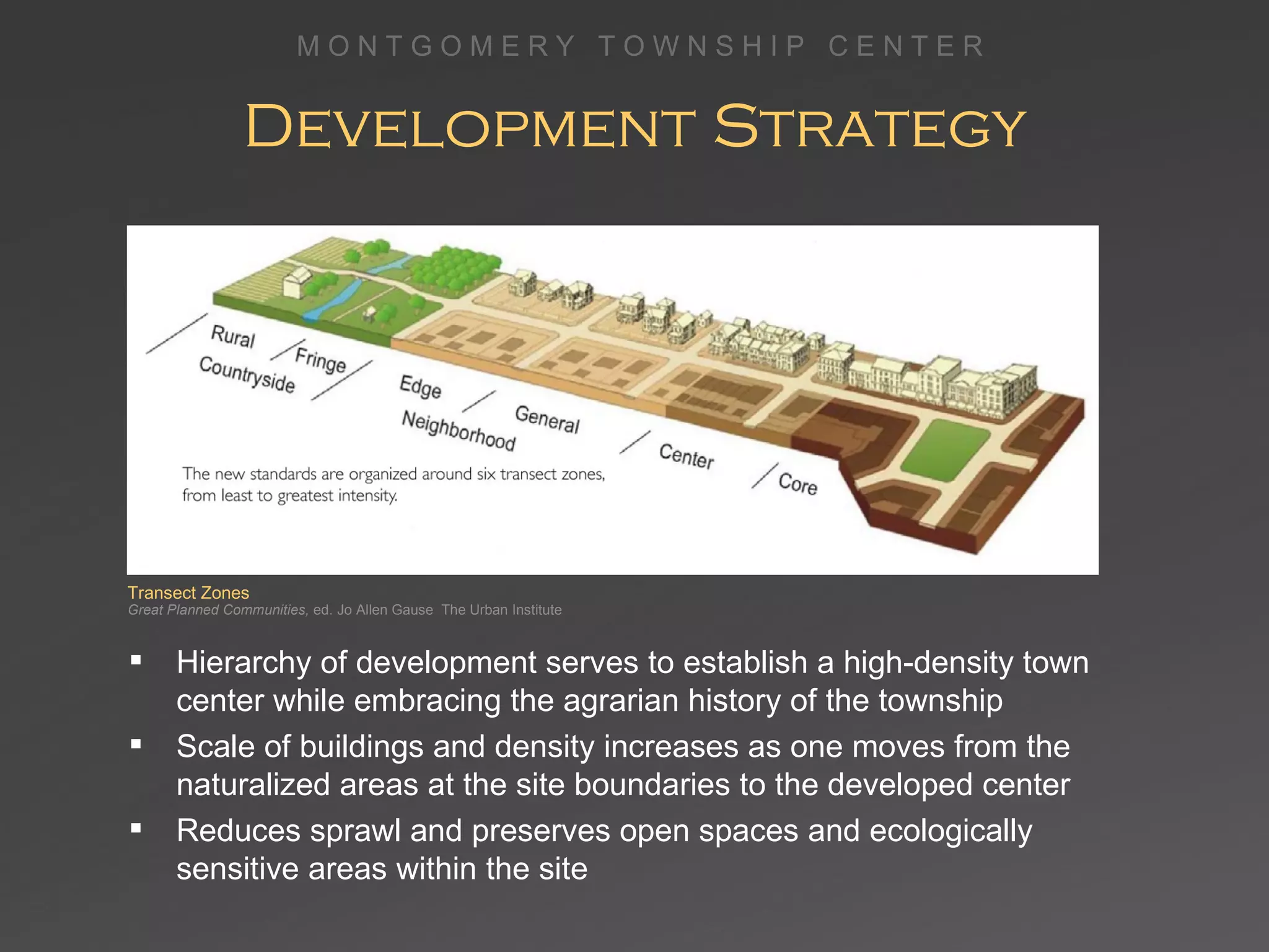
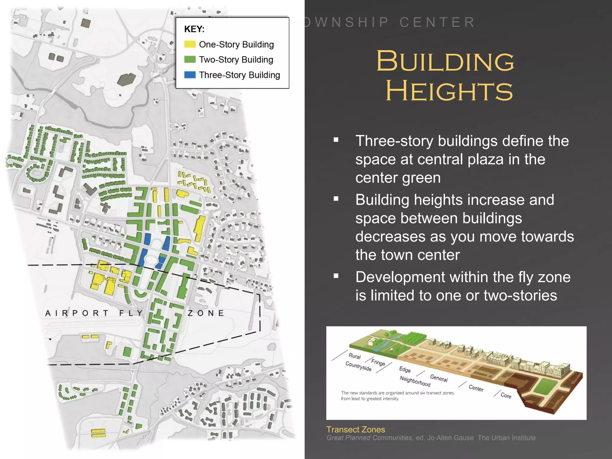
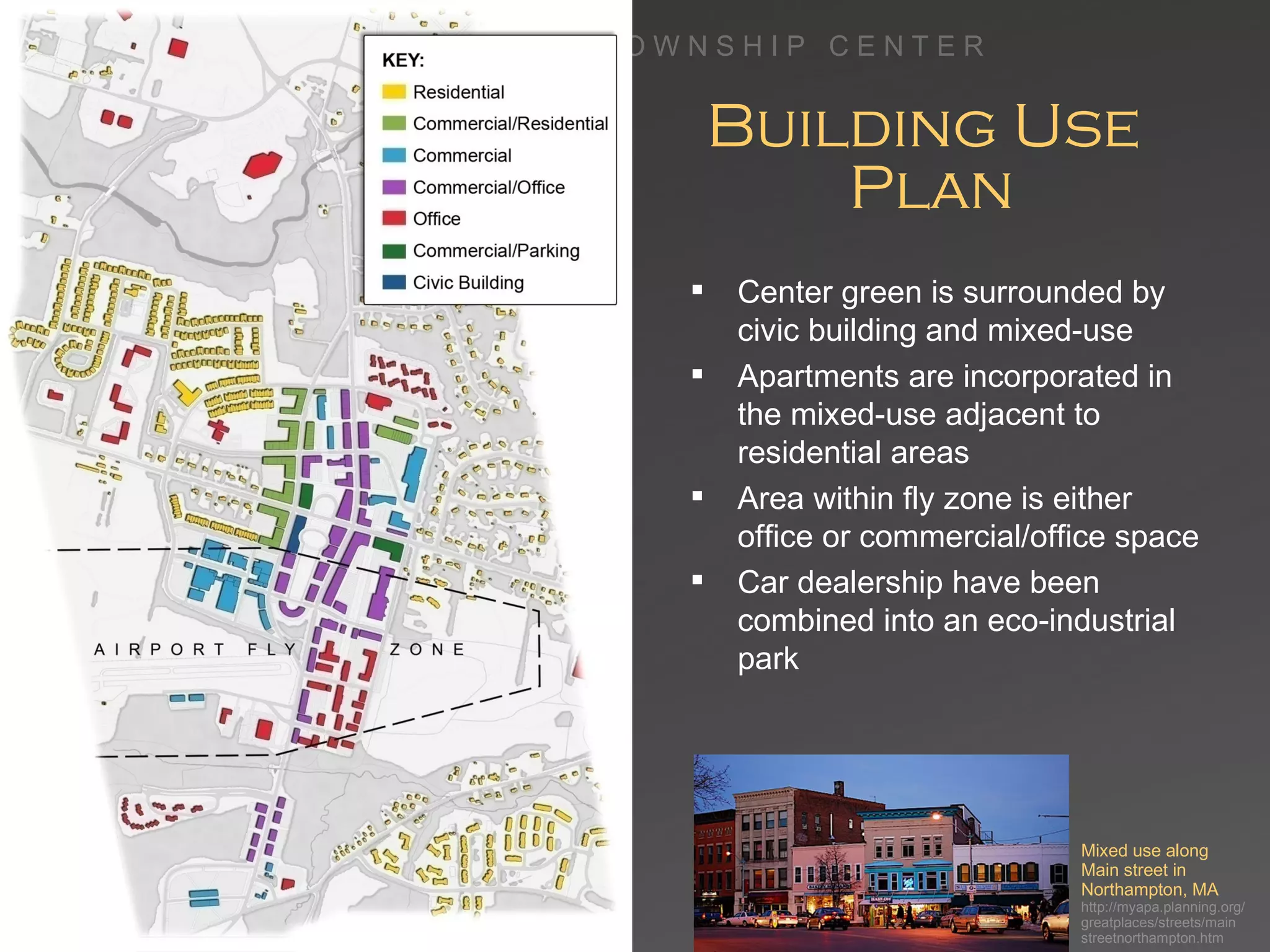
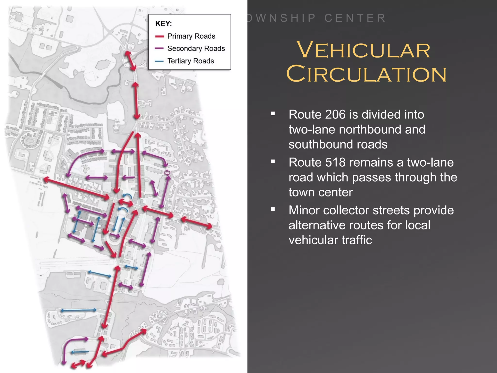
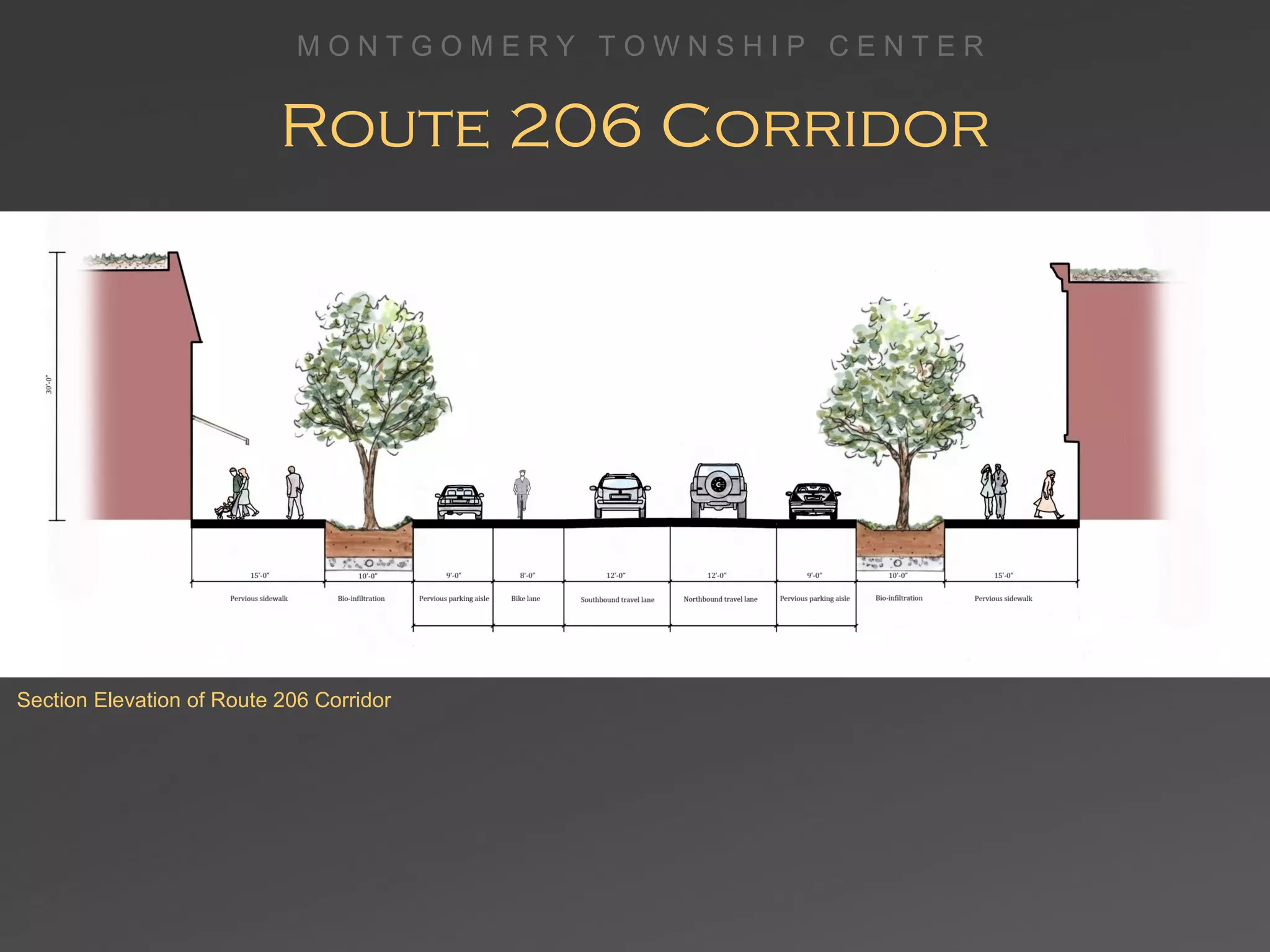
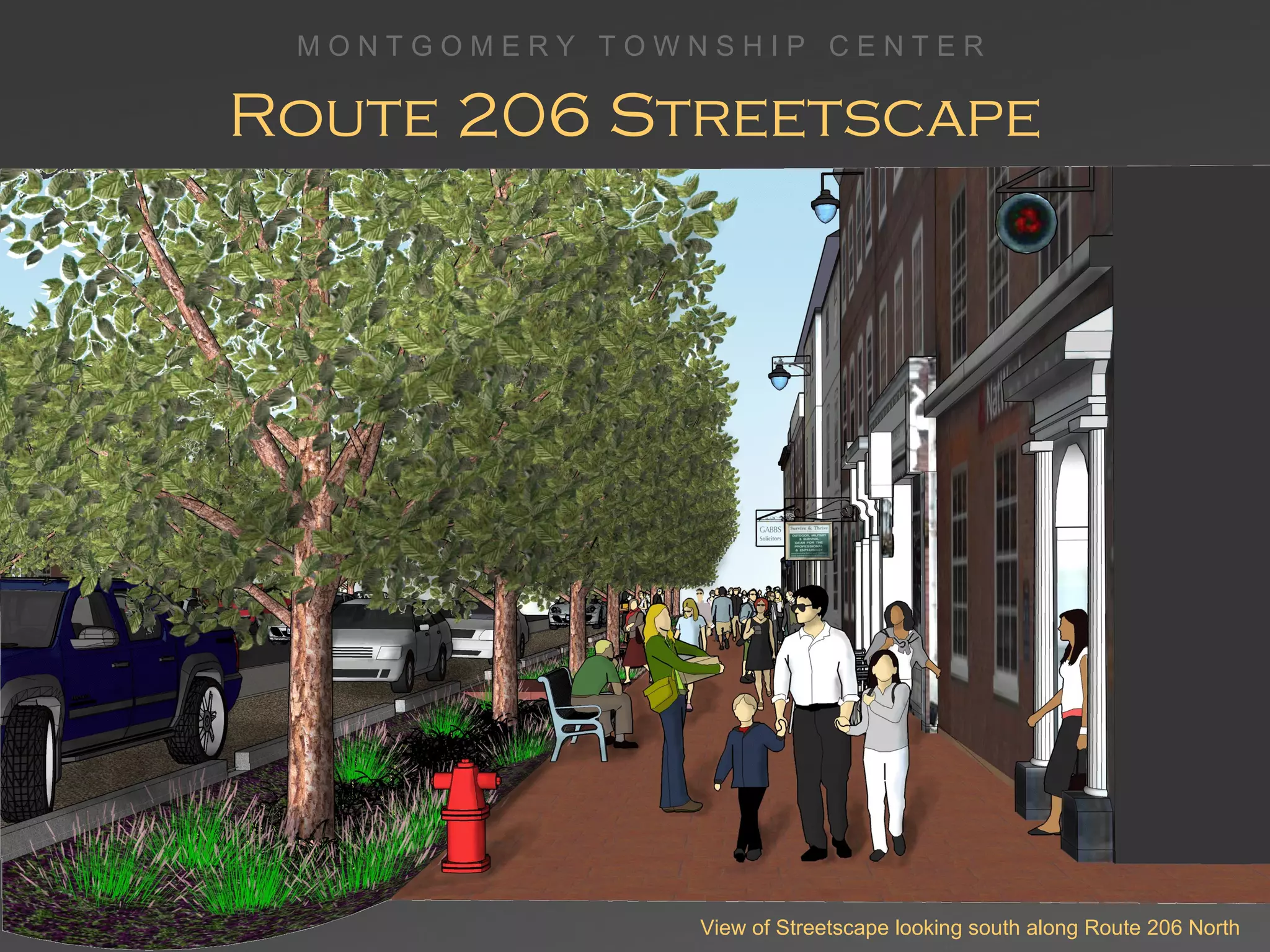
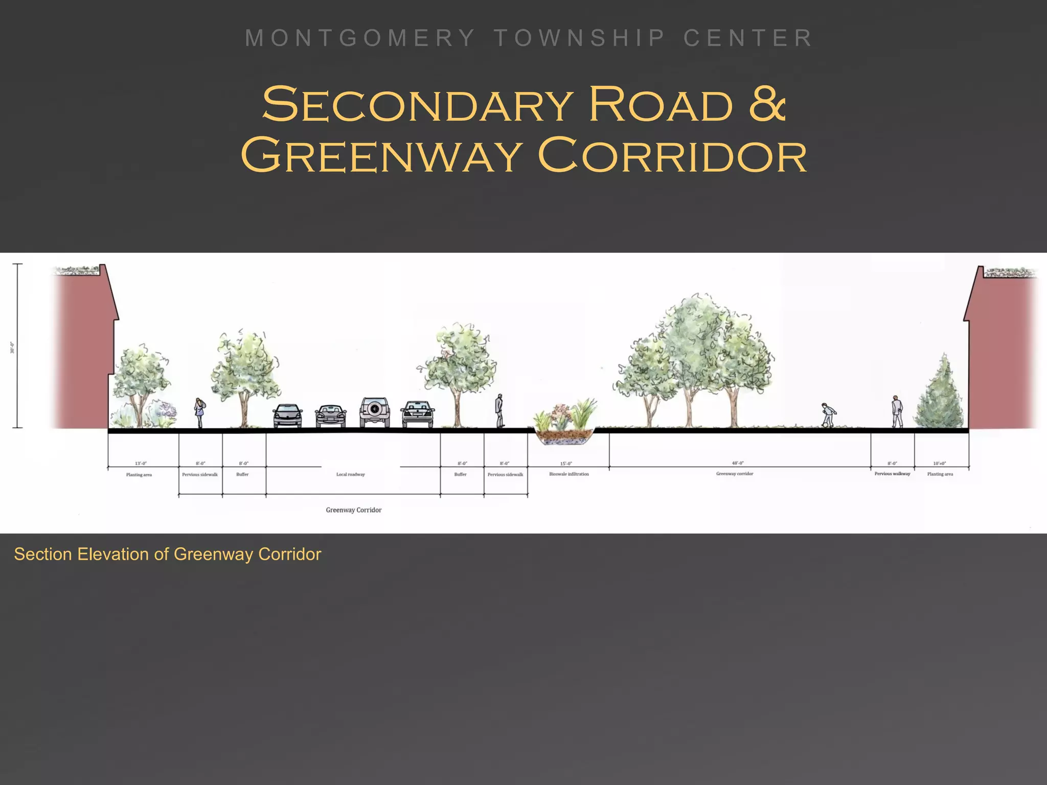
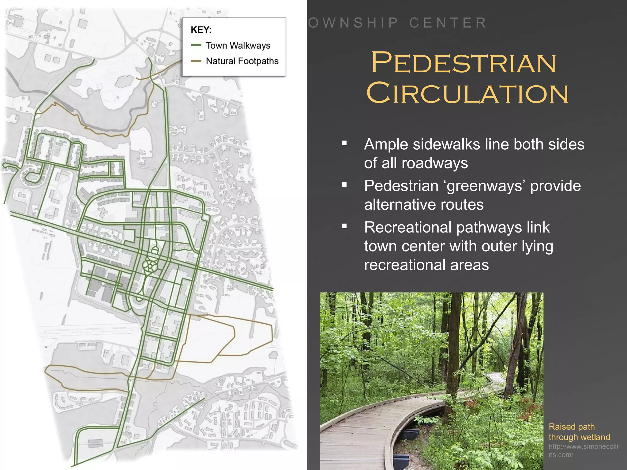
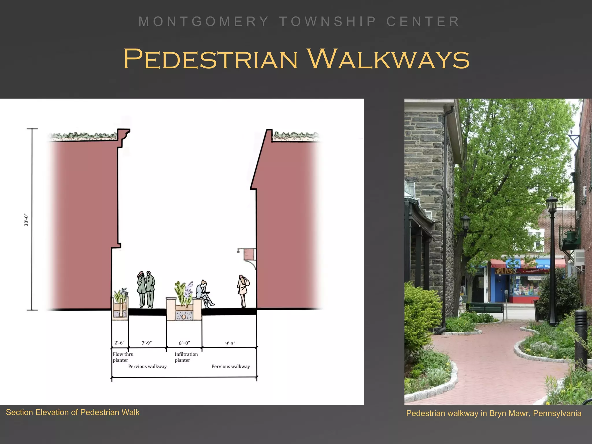
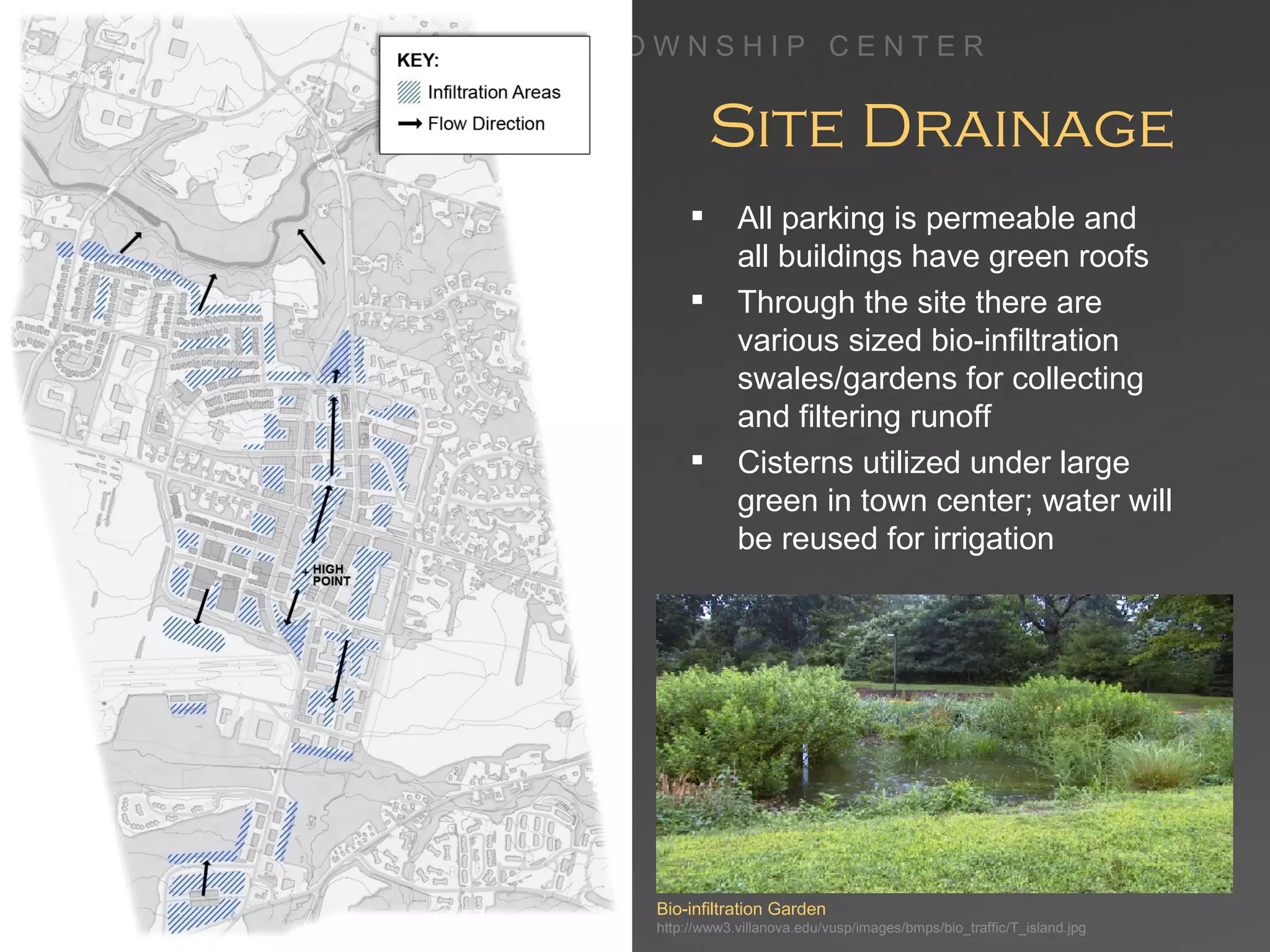
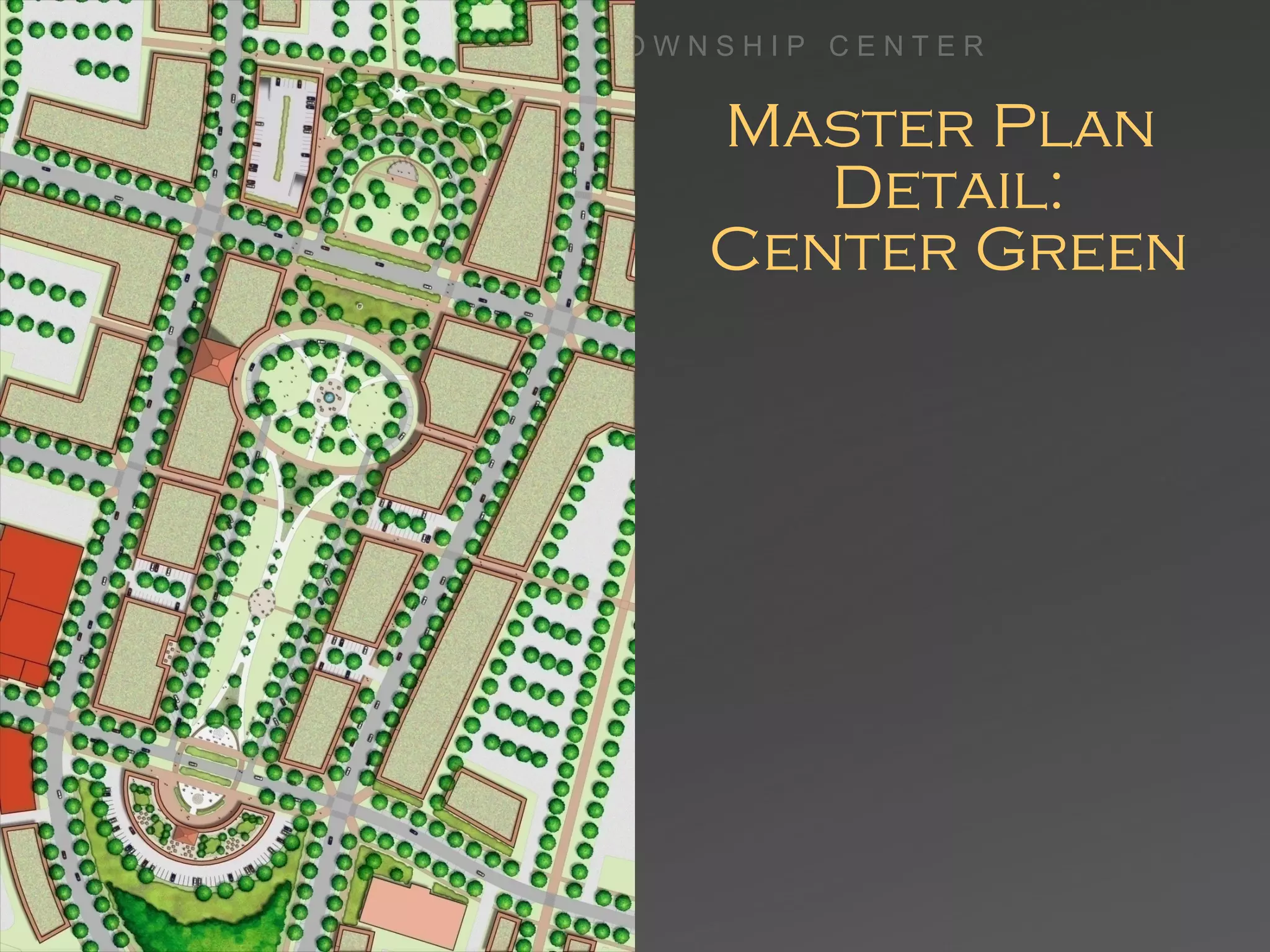
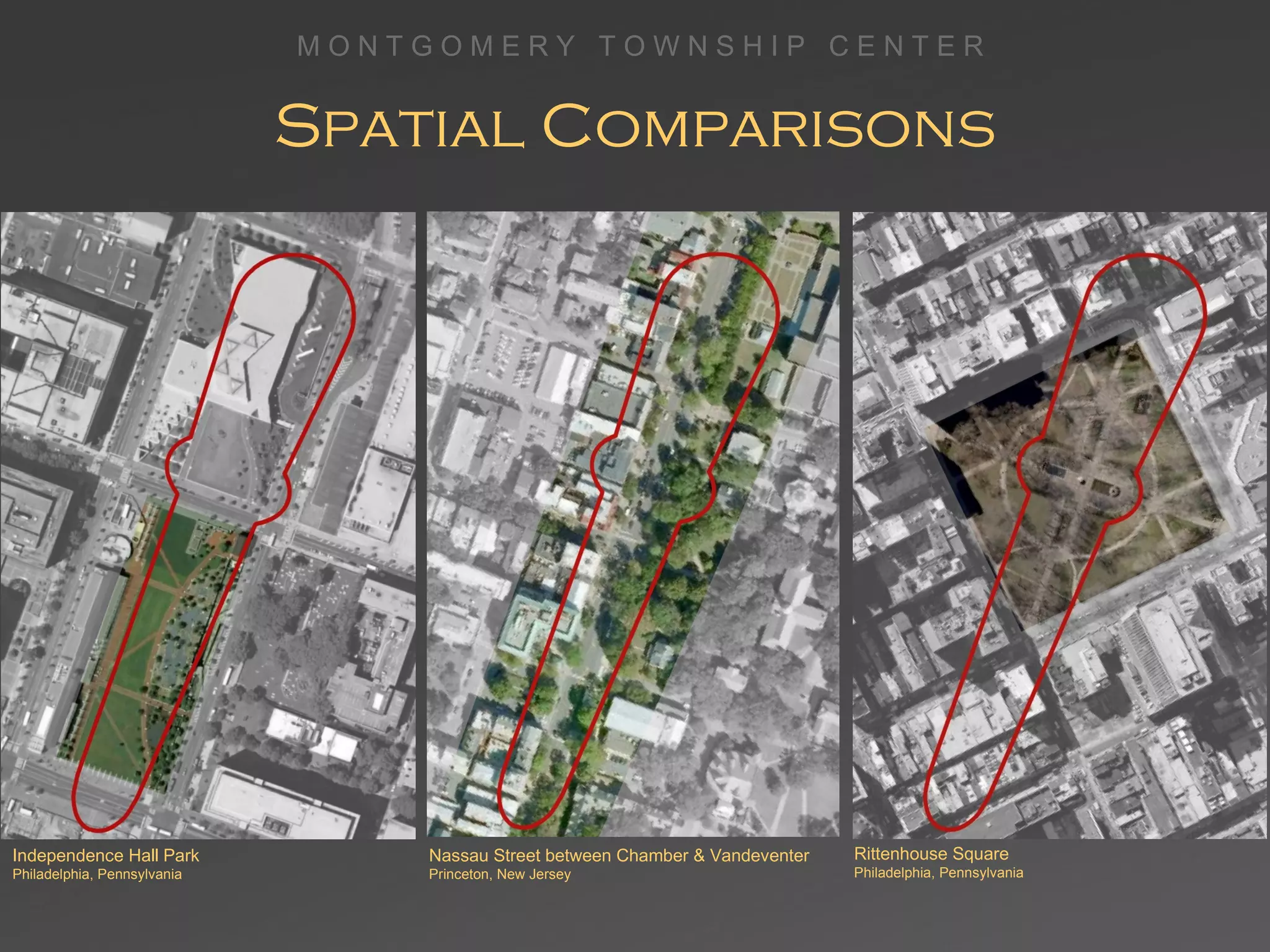
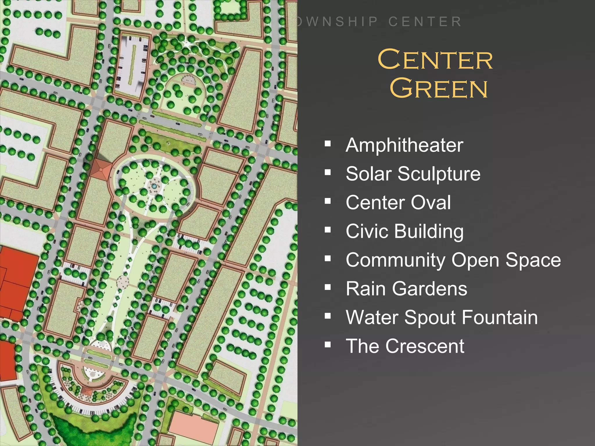
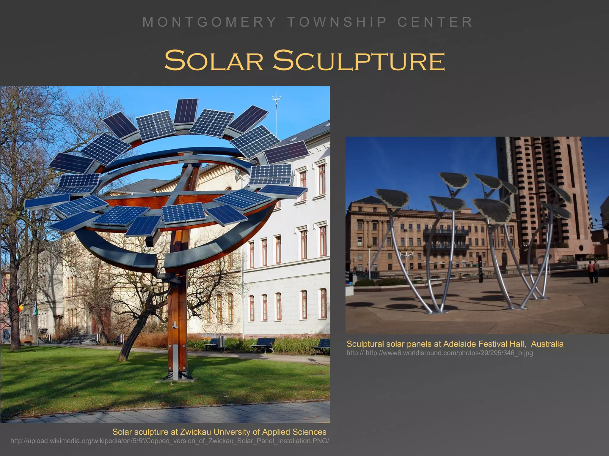
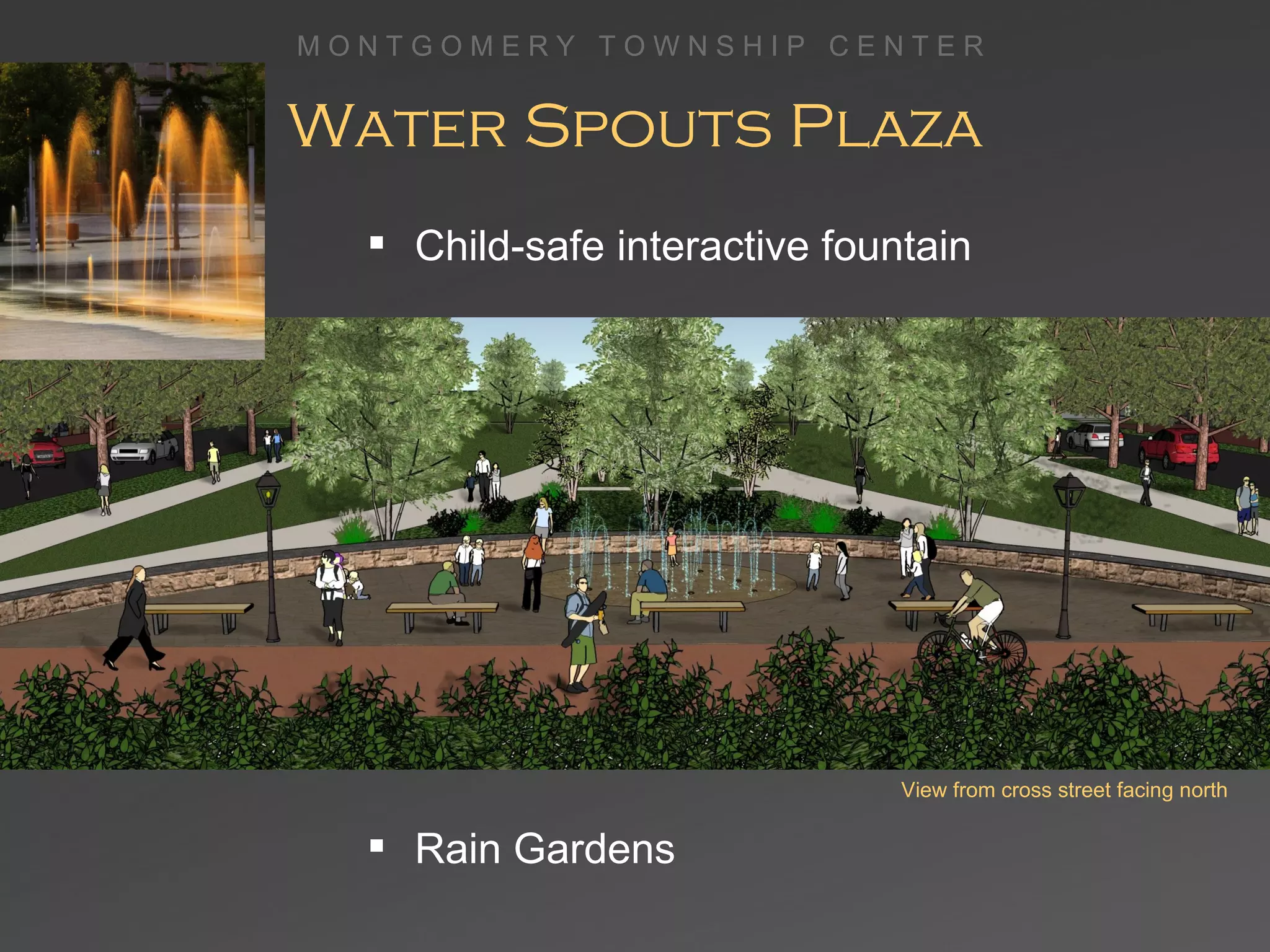
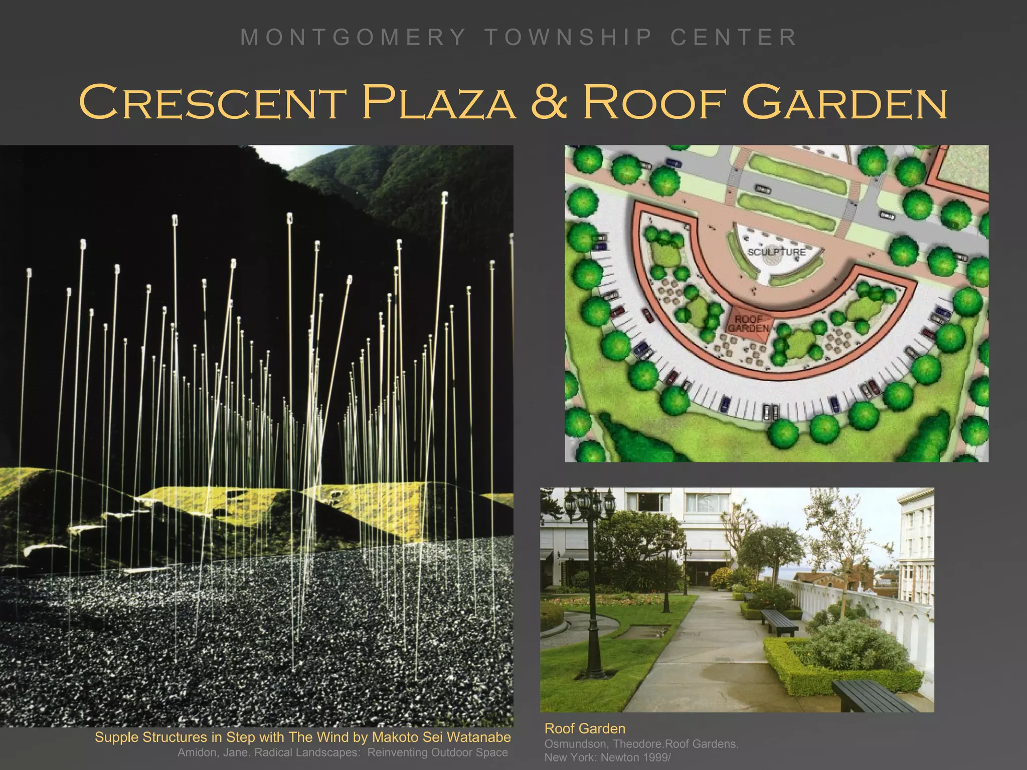
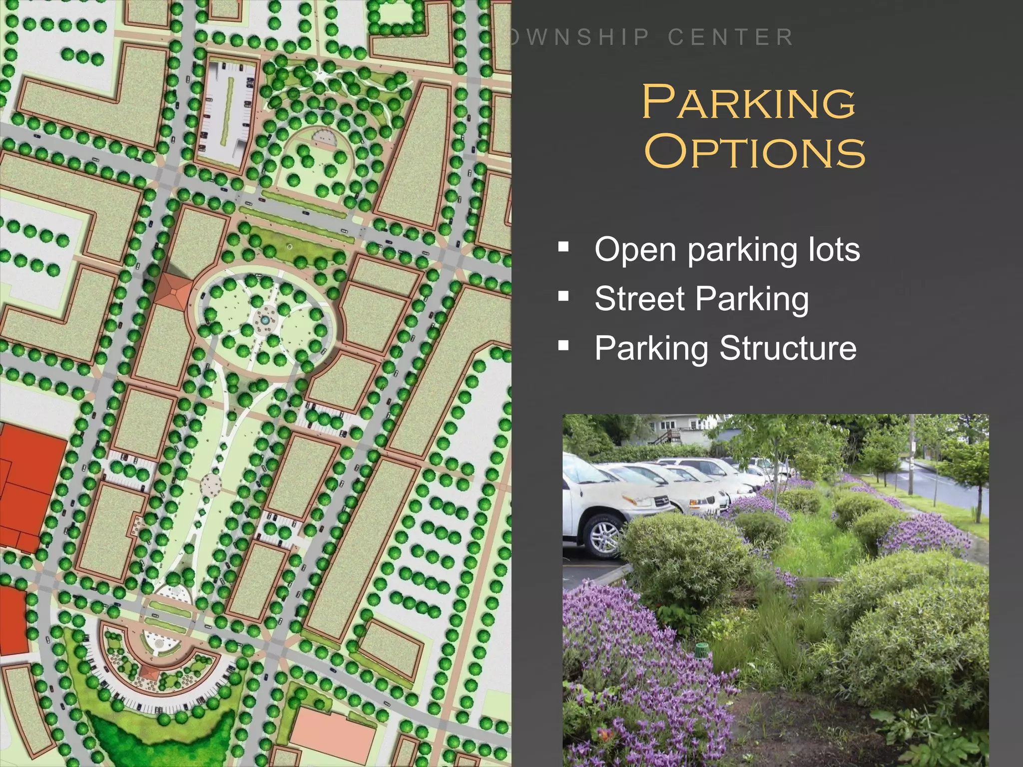
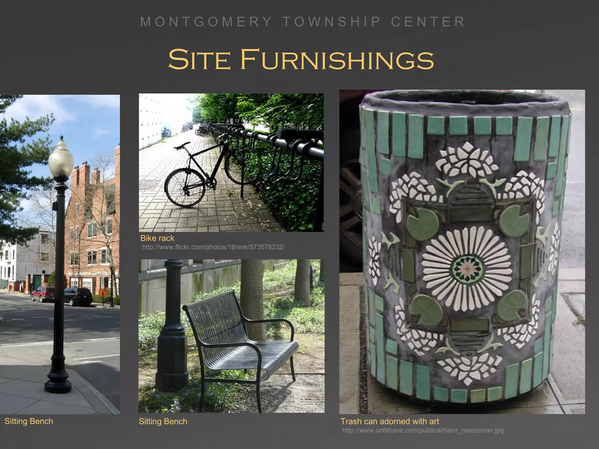
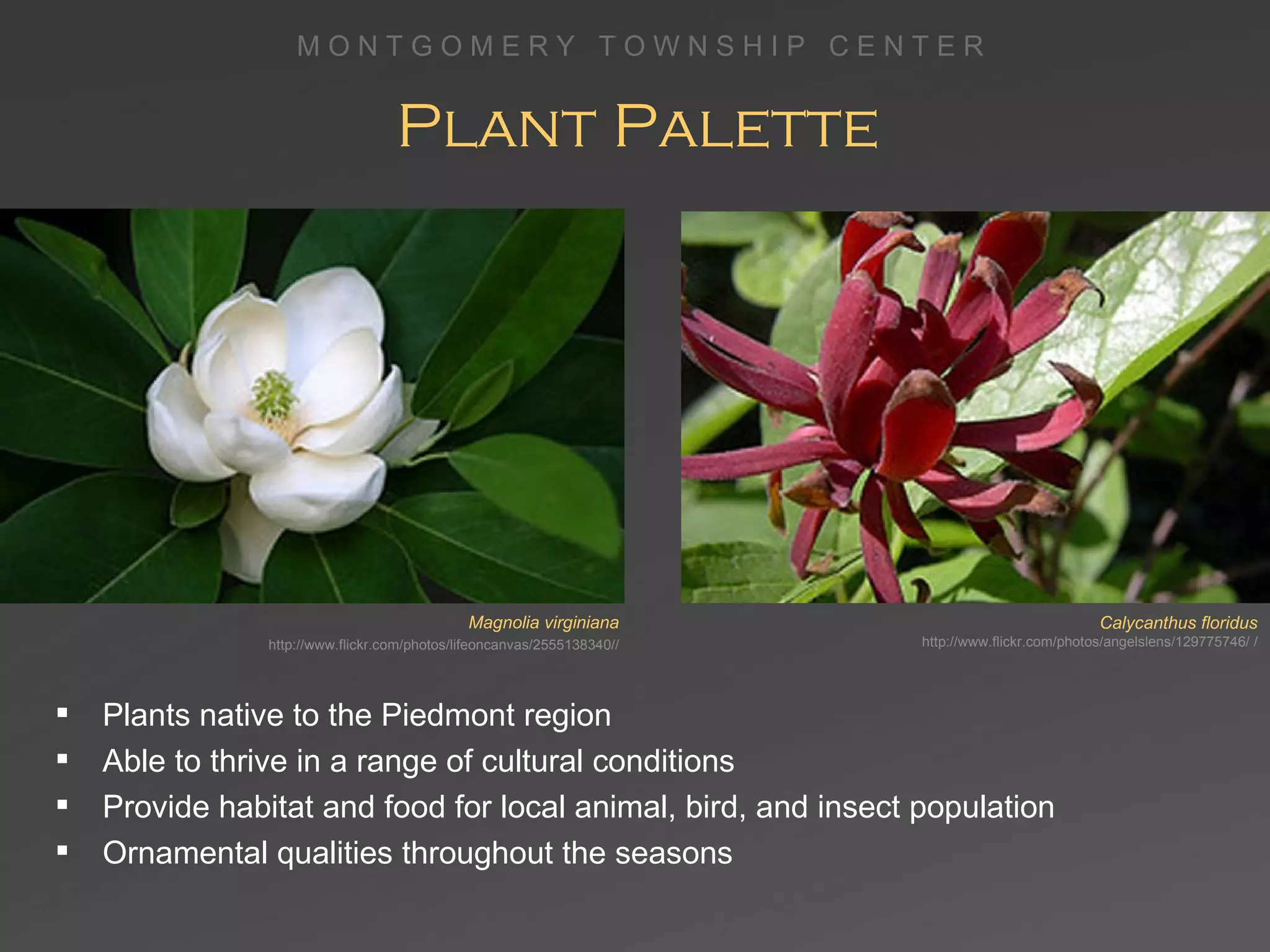
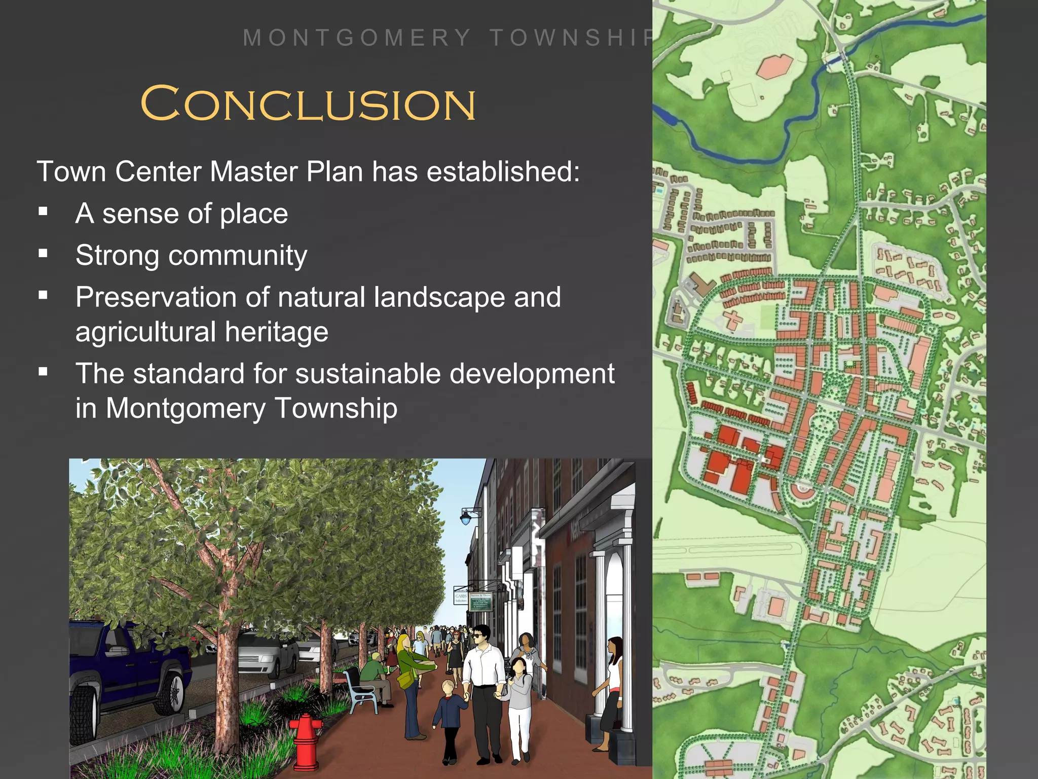
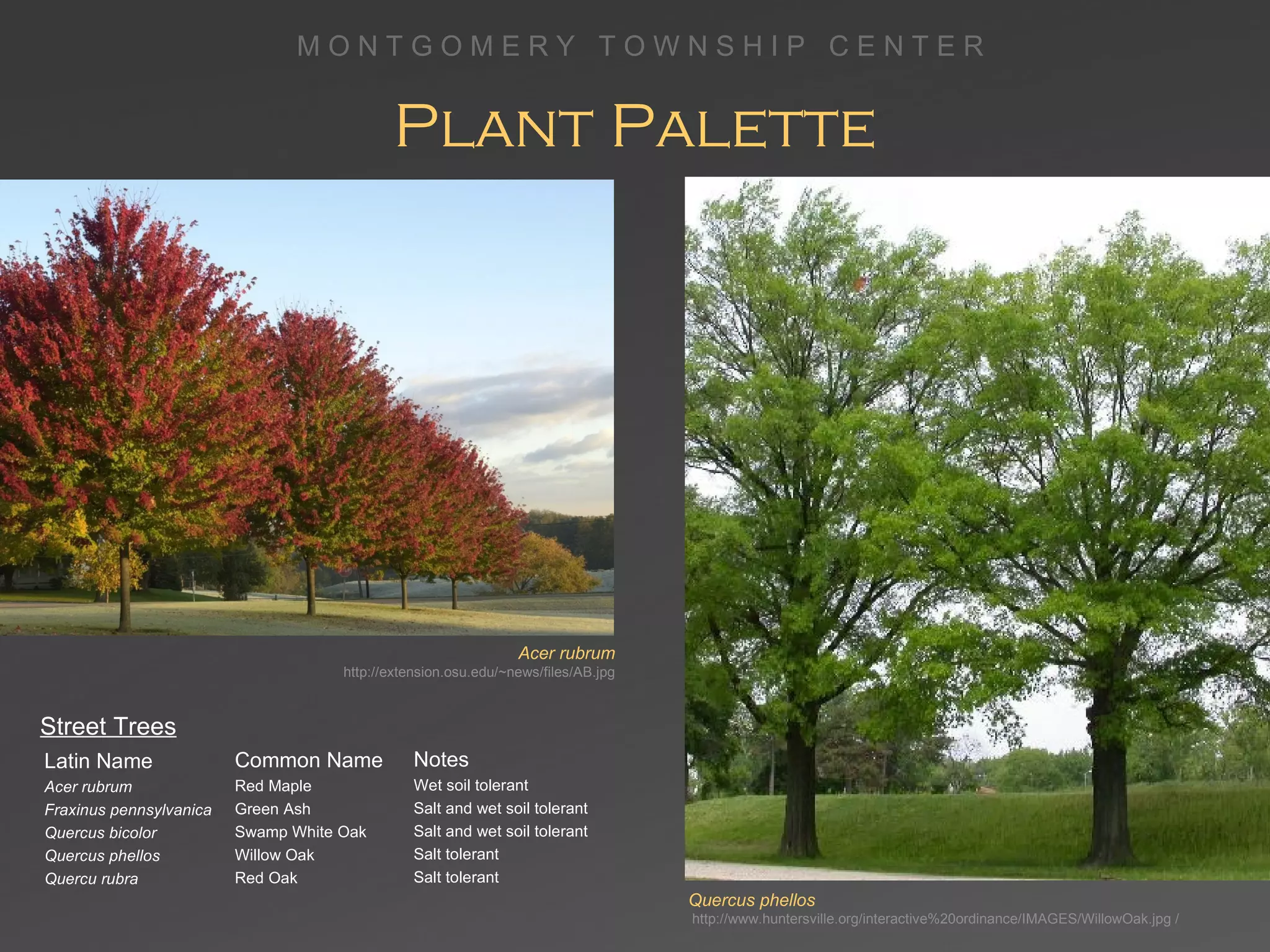
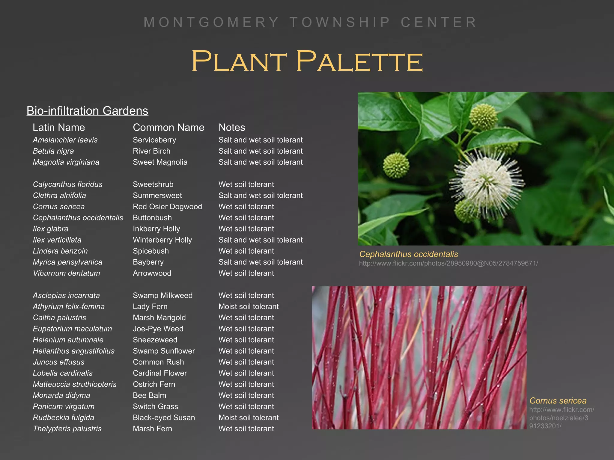
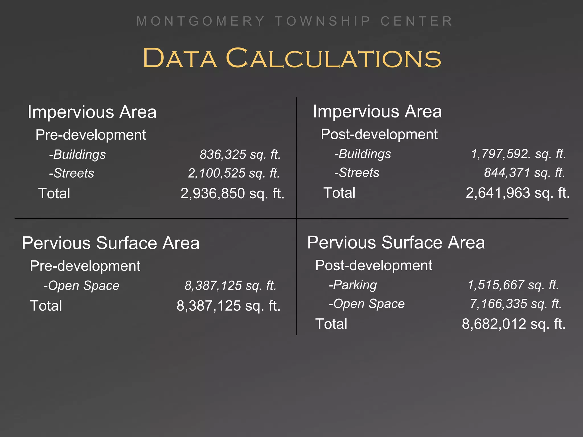
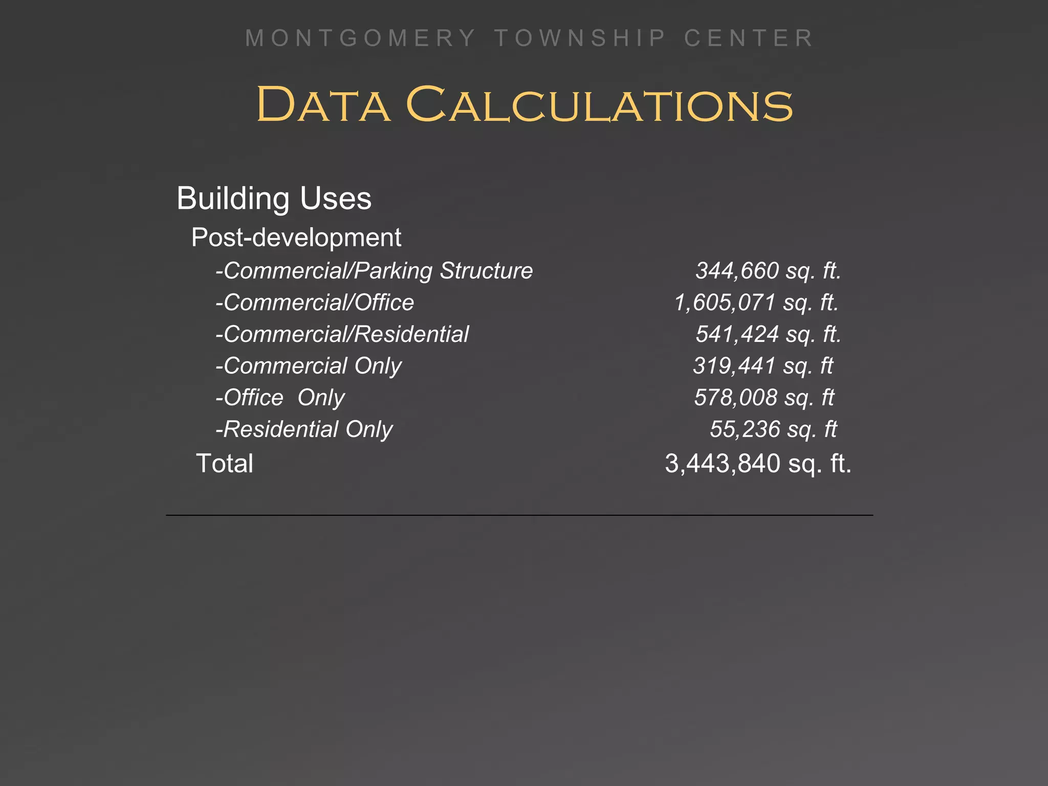
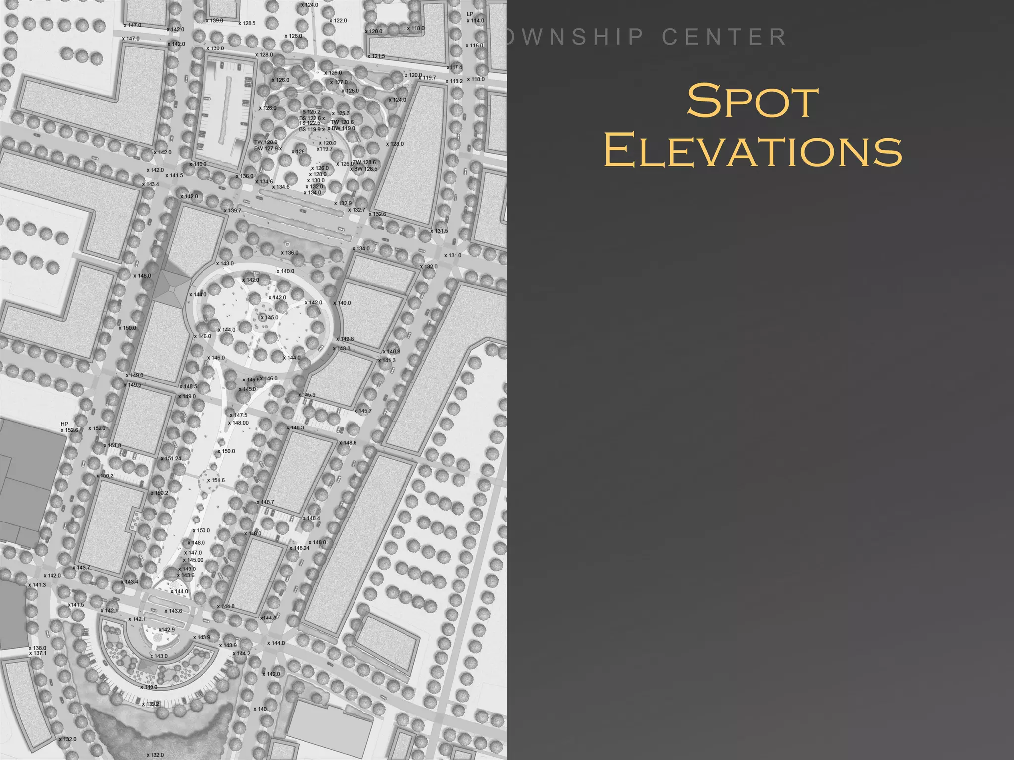
Town Planning Research & Analysis Elizabeth Burns, Christopher Kearney,  Gwendolyn Johnson, Anna Lavinia Schmitz LA4198  LA Design Studio VI  •  Spring 2009  •  Professors Stuart Appel and Bess Wellborn M O N T G O M E R Y  T O W N S H I P  C E N T E R
Sense of Place Elements of a Successful Town Center Cohesive design creating a unique character Active Main Street Safe neighborhoods Beautiful public spaces Good circulation Practices sustainability Quality of Life Main Street, Amityville, NY http://www.gettyimages.com/Search/Search.aspx?contractUrl=2&language=en-US&family=creative& assetType=image&mt=photography&c=color&p=main%20street%20usa&src=standard#4 Neighborhood  gathering place, Buffalo, NY http://www.planning.org/greatplaces/neighborhoods/2007/elmwoodvillage.htm Town parade in Sheridan, Wyoming http://www.planning.org/greatplaces/neighborhoods/2008/downtownsheridan.htm
Welcoming Identity Start with a sense of arrival Street banner in West Chester, PA http://www.haverford.com/docs/Haverford_Township_Comprehensive_Plan_Addendum_Report.pdf Entrance at Playa Vista  Great Neighborhoods Gateway sign in Media, PA http://www.haverford.com/docs/Haverford_Township _Comprehensive_Plan_Addendum_Report.pdf Entrance at Playa Vista  Great Planned Communities,  ed. Jo Allen Gause  The Urban Institute Gateway Arch http://www.planning.org/greatplaces/neighborhoods/2008/downtownsheridan.htm
Main Streets  Human scale in a cohesive design with distinctive architecture Defined at the both ends Provides orientation to its users, and connects well to the larger pattern of ways Encourages human interactions and social activities Promotes safety of pedestrians and vehicles  Offers a variety of interesting activities and uses that create  a varied streetscape Sidewalk café in Gainesville, FL http://www.haverford.com/docs/Haverford_Township_Comprehensive_Plan_Addendum_Report.pdf Pedestrian crosswalk on Main Street http://www.woolpent.com/images/portofolio/ greentowncenter01.jpg
Mixed-use Offers a place to Live-Work-Shop-Play Should consist of a mix of commercial/retail, office/professional and residential uses Allows people to live close to recreation, entertainment and services Provides diversity and choice in services and accommodations Helps to contain urban sprawl and vehicular use Creates vibrancy in the town center throughout the day Mixed-use Main Street http://www.pasackvalleysoldhomesreport.com/image Mixed-use Main Street   http://www.sawanee.com Mixed-use Main Street   http://www.planning.org/greatplaces/streets/2008/washiingtonstreet.htm
Infilling Creates a dense and vibrant  town center Helps to define the image and  feel of the town center Capitalizes on existing  community assets such as parks, infrastructure, shopping areas  and public transportation Provides housing (both affordable and market value) near job centers and public transit Creates new community assets such as day care centers, art districts, neighborhoods and shopping areas Increases the productivity of underused property Decreases the need to develop on open space and agricultural land Example of infilling where the new structure fits into the site with the right scale and form of the neighboring structures   http://www.tndhomes.com Before and after infilling Ellen, Jones D., and Williamson June. "Infill around a live mall." Map.  Retrofitting Suburbia . Hoboken: John Wiley  and Sons, 2009
Neighborhoods Promote socialization amongst diverse age groups and cultures Streets are narrow and tree-lined  Pedestrian and bicycle friendly High-density housing Convenient shopping at locally  owned businesses Common  building forms and materials Relative safety and security Public spaces Established mass transportation Memorable character A variety of functional attributes that contribute to a resident’s day-to-day living (i.e. residential, commercial, or mixed-uses) Residential area http://www.redmon.com Tree covered sidewalks, Eastern Market, Washington, DC http://myapa.planning.org/greatplaces/neighborhoods/easternmarket.htm
Public Spaces Ferry Plaza Farmers Market at San Francisco, California http://www.ferrybuildingmarketplace.com/farmers_market.php  Inverness Square at McKienzie Towne, Alberta, Canada Great Planned Communities,  ed. Jo Allen Gause  The Urban Institute Encourage human interaction Promote community involvement  and ownership Reflect local identity and culture  Safe and welcoming to all Relate to the surrounding land uses Are well maintained
Vehicular Circulation Design roadway width appropriate to intended  speed of travel Promote safe and pleasant travel for all types  of users Improve environmental impact of streets Provide public transportation options for community Allow for alternate routes Allow on-street parking supplemented by parking  lots located behind the main street Traffic Calming Curb extensions Roundabouts Raised crosswalks Tree-lined streets Median islands Use of materials, i.e. cobblestone Narrower roadways Reduce speed limit Parking behind Main Street businesses http://www.planningorg/greatplaces/streets/ 2007/mainstreetnorthampton.htm Residential street with curb extensions in Portland, Oregon http://fam3.stati8670_f5b5babf6_o.jpg
Pedestrian Circulation Pedestrian walkways connect residential neighborhoods, town center, and public open spaces Dense development promotes greater potential  for walking  Provide ample sidewalk width in relation to frequency  and density of use Short blocks allow for quicker routes One mile walk in sprawling development http://www.walkscore.com/walkableneighborhoods.shtml One mile walk in dense development http://www.walkscore.com/walkableneighborhoods.shtml A pedestrian-friendly street in Atlanta, Georgia http://www.flickr.com/photos/ironchapman/339261944/
Sustainability Stormwater BMPs minimize land disturbance and runoff, recharge aquifers, preserve water quality restoring the ecological hydrologic balance Street trees, green roofs and green networks clean pollutants from the air, minimize the heat island effect and improve energy efficiency effectively reducing the carbon footprint Planters along the street convey, clean and infiltrate runoff  from NW 12 Avenue In Portland, Oregon. http://www.asla.org/awards/2006/06winners/341.html Smart Growth Principles  engage sustainability in the town planning process utilizing inherent ecological processes and stormwater best management practices (BMPs) and materials
Low-Impact Development Eco-based watershed approach Protects and expands the natural surface drainage Treatment Train: incorporates surface drainage and infiltration  in concert with stormwater  Best Management Practices  (BMP) Restored Prairie surrounding residences as  first step in stormwater train at Prairie Creek, Gray’s Lake, Illinois http://www.prairiecrossing.com/pc/site/index.html At Prairie Creek, a four step treatment train conveys runoff through vegetated swales, restored prairies and stormwater wetlands to a constructed lake removing 90% pollutants and solids, decreasing stormwater volume and increasing infiltration
Stormwater Management Connecting and integrating regional and neighborhood systems As a resource to replenish urban streams and balance hydrology As an amenity — environmentally, culturally, artistically and socially Enhancing urban spatial patterns  Restoring natural functions Heritage Park, Minnesota Gerling, c. & Keller, R.,  Skinny Streets and Green Neighborhoods At Heritage Park,  a greenway utilizes stormwater gardens  to link neighborhoods divided by a heavily traveled roadway Mount Tabor Middle School Rain Garden, Portland, Oregon Kevin Robert Perry, ASLA http://www.asla.org/awards/2007/07winners/517_nna.html
Stormwater BMP Bioswales and infiltration basins Infiltration planters and  rain gardens Eco and green roofs Trees and vegetation Cisterns Pervious pavement, concrete, asphalt, pavement blocks and turf blocks Bioswale intercepting and infiltrating stormwater from adjacent parking lot http://www.portlandonline.com/bes/index.cfm?c=43110&
Energy Efficiency Generate energy: Solar panels Passive and active solar systems Wind turbines Conserve energy: Green roofs Trees  Green buildings Solar panel array over a parking lot reduces heat island effect as well as collecting energy Green roof, Robertson Building, Toronto http://www.flickr.com/photos/horticulturaltherapystudent/864775470/page2/
Montgomery Township Region Mid-Atlantic region of USA Central New Jersey, approximately halfway between New York City, NY and Philadelphia, PA and within commutable distance to both In southern Somerset County, just north of Princeton, NJ
Montgomery Township Region History: Leni Lenape lands until European settlers 1688 Somerset County established 1702 Montgomery Township established by Dutch and English people from New Amsterdam (future New York City)  Rocky Hill is oldest town in Montgomery Township 1927 Route 206 built Primarily agricultural until land  became more valuable than  crops; housing boom after WWII 1872 map of  Montgomery  Township
Montgomery Township Region Population Growth: mid 1900’s = 2,350 1970 = 5,103 2000 = 17,481 2007 = 23,023 School district rating is very high. The property taxes are also high, so once children graduate from high school many families leave the area Estimated median household income in 2007: $83,578 (it was $67,346 in 2000) Princeton:   $83,578 New Jersey:   $67,035 Estimated median house or condo value in 2007: $760,424 (it was $338,700 in 2000) Princeton:   $760,424 New Jersey:   $372,300
Aspect: Solar Exposure Solar panels, Plaza Apartments roof,  San Francisco, CA http://www.flickr.com/photos/kqedquest/446543194/ Solar panels are possible in Montgomery Township Rutgers University is installing an array of 7,200 solar panels to provide electricity for its Livingston campus http://www.city-data.com
Aspect: Temperature  & Precipitation Great for growing vegetation Green Park, London http://www.flickr.com/photos/ugardener/2923476607/sizes/l/ http://www.city-data.com
Aspect: Wind Wind not consistent enough for typical U.S. wind turbines to be used New technologies are being developed for lesser wind capacities in Europe and could be available here soon Central London A pair of turbines  were installed in early June 2008 at Workplace Development  Center  in Central London. The minimum wind speed required for these turbines is 4.5m/s. www.njcleanenergy.com/files/file/John_Halley.pdf http:www.quietrevolution.couk/projects.htm http://www.city-data.com
Regional Roads Approximately  half-way between  New York City and Philadelphia Near major interstates Located along a connector road between I-95 & I-287 M O N T G O M E R Y  T O W N S H I P  C E N T E R
Regional Amenities Currently available amenities in the surrounding region Princeton offers many amenities utilized by residents of Montgomery Township
Local Vehicular Traffic Route 206 is a heavily traveled  thoroughfare bisecting the site. It is two lanes wide with turn lanes Route 518 is a major collector Orchard Road travels east/west at the top of the site Cherry Valley Road travels east/west at the bottom of  the site M O N T G O M E R Y  T O W N S H I P  C E N T E R
Pedestrian & Bicycle & Bus Circulation Although there are pedestrian and bicycle pathways in the Township, few are in the site Bus only connects to Princeton; no other service is available to the site M O N T G O M E R Y  T O W N S H I P  C E N T E R Bicyclers meet Route 206
Open Spaces While there is open spaces throughout the Township, our site is lacking open spaces. Possible green connection between township-owned lands at the north of the site and the southwest of the site M O N T G O M E R Y  T O W N S H I P  C E N T E R
Vegetation Land around the site contains substantial tree coverage but very little within the site Substantial open space however much of it is disturbed through agriculture and use as sports fields M O N T G O M E R Y  T O W N S H I P  C E N T E R Open meadow field in Van Horne Park
Waterways &  Critical Areas Creeks across the north and south ends of the site All soils are buildable except along waterways,  in wetland zones and where slope exceeds 15% M O N T G O M E R Y  T O W N S H I P  C E N T E R
Water On The Site The intersection of Routes 206 and 518  are practically on a ridgeline that defines  2 watersheds: the Beden Brook and the Stony Brook-Millstone Watersheds. Making sure that water flowing off the site  is well-filtered before entering the creeks  is crucial to the health of the waterways Image of Beden Brook  M O N T G O M E R Y  T O W N S H I P  C E N T E R
Zoning The majority of the lands along 206 are zoned highway commercial or research/ engineering/office The airport has a restricted zone overlay Overlay districts can be applied to strengthen the town center design M O N T G O M E R Y  T O W N S H I P  C E N T E R
What Is On The Site M O N T G O M E R Y  T O W N S H I P  C E N T E R Eating Establishments (14) Medical Offices (10) Health Food Store (1) Caterers (1) UPS Store (1) Liquor Store (1) Convenience Stores (5) Car Dealerships (5) Banks (4) Commercial Complexes (4) Beauty Salons/Nail Salons/Barbers (8) Auto Related (2) Clothing Stores (2) Home Furnishings (1) Pet Store (1) Health Clubs (2) Super Market (1) Movie Theater (1) Airport (1) Public Park (1) Cleaners (2) Shoe repair (1) Sport Store (1) There is a wide variety of independently owned stores on the site. There are few chain retail outlets.
Typical Office Parks Montgomery Commons Office Park and Medical  Center located off of Route 206 Strip development along Route 206 with very  wide setback  and obscured view from road
Typical Commercial Strip development along Route 206 with very  wide setback  and obscured view from road Isolated buildings housing a few  businesses with  parking in front  located along Route 206  One of many car dealerships along Route 206
Typical Residential Apartment complex along Princeton Avenue New high-end development house Duplex along Route 518 in Rocky Hill
Opportunities & Constraints M O N T G O M E R Y  T O W N S H I P  C E N T E R


Name? Site needs own identity Site is primarily  2 zip codes within Montgomery Township People south of Rt. 518 consider area Princeton People north of Rt. 518 consider area Skillman M O N T G O M E R Y  T O W N S H I P  C E N T E R
Future Possibilities A clearly defined, sustainable town center  with memorable, unique character that offers a full array of amenities within walking distance, where people come together to live, work, socialize and build great memories
Master Plan and  Center Green Design Elizabeth Burns, Christopher Kearney,  Gwendolyn Johnson, Anna Lavinia Schmitz LA4198  LA Design Studio VI  •  Spring 2009  •  Professors Stuart Appel and Bess Wellborn M O N T G O M E R Y  T O W N S H I P  C E N T E R
Establish sense of place Establish a sense of community Preserve and enhance value of natural landscape Establish Montgomery Township as a model of sustainable practices Goals Chestnut Hill, PA
Goals & Objectives Establish a sense of place Provide a sense of arrival Create a cohesive town center through scale, proportions and materials Develop a unique character with beautiful public spaces, active main streets and safe neighborhoods Pedestrian crosswalk on Main Street http://www.woolpent.com/images/portofolio/greentowncenter01.jpg Gateway Arch http://www.planning.org/greatplaces/neighborhoods/2008/downtownsheridan.htm Spring Flowers  In Rocky Hill
Goals & Objectives Establish a sense of community Develop a mixed-use town center where residents can live, work, and play High density development where all amenities are within a reasonable walking distance and linked by a network of pedestrian walkways Provide a variety of public gathering spaces for large communal events such as festivals, farmers markets, and concerts Street Festival Princeton, NJ Strolling shoppers
Goals & Objectives Preserve agricultural heritage and enhance value of natural landscape Preserve open space intended for future development through high density development, transfer development rights, and farm preservation Restore and protect riparian zones by increasing vegetated quality of riparian buffer zone and implementing extensive stormwater management strategies Access to natural areas provides recreational and educational opportunities Image of Beden Brook Red barn at Orchard Road
Goals & Objectives Establish Montgomery Township as a model of sustainable practices All new construction is to be LEED certified or equivalent Green roofs in concert with solar panels on all buildings to reduce overall carbon footprint, reduce stormwater runoff and the heat island effect Reuse captured graywater for irrigation Utilize permeable paving materials to increase stormwater infiltration and capture runoff before it reaches local waterways Establish community gardens and promote locally grown food Community Gardens http://www.flickr.com/photos/wetgraphite/2464114637/ Green roof and Solar Panels
Land Use Plan Route 206 is divided through the town center creating separate north and southbound branches Implemented some of the previously proposed loop roads High density mixed-use  town center Mixed-use retail/residential provides a transition to existing residential zones Connection to approved Montgomery Promenade has been incorporated with some alterations Expanded riparian buffer zones and preserved open space through transfer of development rights
Development Strategy Hierarchy of development serves to establish a high-density town center while embracing the agrarian history of the township Scale of buildings and density increases as one moves from the naturalized areas at the site boundaries to the developed center Reduces sprawl and preserves open spaces and ecologically sensitive areas within the site  Transect Zones  Great Planned Communities,  ed. Jo Allen Gause  The Urban Institute
Center Green is heart of the  town plan Sustainable, walkable community with mixed-use development and range of housing options Retained many existing structures and infilled for  greater density New structures are mixed-use and LEED certified or equivalent Master  Plan
Building  Heights Three-story buildings define the space at central plaza in the center green Building heights increase and space between buildings decreases as you move towards the town center Development within the fly zone is limited to one or two-stories Transect Zones  Great Planned Communities,  ed. Jo Allen Gause  The Urban Institute
Building Use  Plan Center green is surrounded by civic building and mixed-use Apartments are incorporated in the mixed-use adjacent to residential areas Area within fly zone is either office or commercial/office space Car dealership have been combined into an eco-industrial park Mixed use along Main street in  Northampton, MA http://myapa.planning.org/ greatplaces/streets/main streetnorthampton.htm
Vehicular  Circulation Route 206 is divided into  two-lane northbound and southbound roads Route 518 remains a two-lane road which passes through the town center Minor collector streets provide alternative routes for local vehicular traffic
Route 206 Corridor Section Elevation of Route 206 Corridor
Route 206 Streetscape View of Streetscape looking south along Route 206 North
Secondary Road & Greenway Corridor Section Elevation of Greenway Corridor
Pedestrian  Circulation Ample sidewalks line both sides of all roadways Pedestrian ‘greenways’ provide alternative routes Recreational pathways link town center with outer lying recreational areas Raised path through wetland http://www.simonecollins.com/
Pedestrian Walkways Section Elevation of Pedestrian Walk Pedestrian walkway in Bryn Mawr, Pennsylvania
Site Drainage Bio-infiltration Garden http://www3.villanova.edu/vusp/images/bmps/bio_traffic/T_island.jpg All parking is permeable and  all buildings have green roofs Through the site there are various sized bio-infiltration swales/gardens for collecting and filtering runoff Cisterns utilized under large green in town center; water will be reused for irrigation
Master Plan  Detail: Center Green
Spatial Comparisons Independence Hall Park Philadelphia, Pennsylvania Rittenhouse Square Philadelphia, Pennsylvania Nassau Street between Chamber & Vandeventer Princeton, New Jersey
Center  Green Amphitheater Solar Sculpture Center Oval  Civic Building Community Open Space Rain Gardens Water Spout Fountain The Crescent
Amphitheater Section Elevation of Amphitheater at North End of Center Green Columns at entrance  of Playa Vista  Great Planned Communities,  ed.  Jo Allen Gause  The Urban Institute Stage Performance www.gettyimage.com Grassy Slope Sitting Area of Amphitheater
Solar Sculpture Solar sculpture at Zwickau University of Applied Sciences  http://upload.wikimedia.org/wikipedia/en/5/5f/Copped_version_of_Zwickau_Solar_Panel_Installation.PNG/ Sculptural solar panels at Adelaide Festival Hall,  Australia http:// http://www6.worldisround.com/photos/29/295/346_o.jpg
Center Oval View of Center Oval from outside the Civic Building
Water Spouts Plaza View from cross street facing north Child-safe interactive fountain Rain Gardens
Crescent Plaza & Roof Garden Supple Structures in Step with The Wind by Makoto Sei Watanabe  Amidon, Jane. Radical Landscapes:  Reinventing Outdoor Space  Roof Garden Osmundson, Theodore.Roof Gardens. New York: Newton 1999/
Parking  Options Open parking lots Street Parking Parking Structure
Site Materials Brick eco-paver Light grey pea gravel Cobblestone Belgium block curbs Ornamental crosswalks
Site Furnishings Bike rack  http://www.flickr.com/photos/16nine/573578232/ Sitting Bench Sitting Bench Trash can adorned with art  http://www.on6thave.com/publicart/ann_meersman.jpg
Plant Palette Plants native to the Piedmont region Able to thrive in a range of cultural conditions Provide habitat and food for local animal, bird, and insect population Ornamental qualities throughout the seasons Magnolia virginiana   http://www.flickr.com/photos/lifeoncanvas/2555138340// Calycanthus floridus  http://www.flickr.com/photos/angelslens/129775746/ /
Implementation Community Involvement Hold public meetings for community feedback and ideas Brain storm for town center names Development Priorities Adjust approved Montgomery Promenade design to accommodate new south-bound  206 branch Install new south-bound 206 branch Establish Center Green with new Civic Building Develop other areas as possible
Conclusion Town Center Master Plan has established: A sense of place Strong community Preservation of natural landscape and agricultural heritage The standard for sustainable development in Montgomery Township
Appendices
Plant Palette Quercus phellos  http://www.huntersville.org/interactive%20ordinance/IMAGES/WillowOak.jpg / Acer rubrum  http://extension.osu.edu/~news/files/AB.jpg Street Trees Latin Name Acer rubrum Fraxinus pennsylvanica Quercus bicolor Quercus phellos Quercu rubra  Common Name Red Maple Green Ash Swamp White Oak Willow Oak Red Oak Notes Wet soil tolerant Salt and wet soil tolerant Salt and wet soil tolerant Salt tolerant Salt tolerant
Plant Palette Cornus sericea http://www.flickr.com/ photos/noelzialee/3 91233201/ Bio-infiltration Gardens Latin Name Amelanchier laevis Betula nigra Magnolia virginiana Calycanthus floridus Clethra alnifolia Cornus sericea Cephalanthus occidentalis Ilex glabra Ilex verticillata Lindera benzoin Myrica pensylvanica Viburnum dentatum Asclepias incarnata Athyrium felix-femina Caltha palustris Eupatorium maculatum Helenium autumnale Helianthus angustifolius Juncus effusus Lobelia cardinalis Matteuccia struthiopteris Monarda didyma Panicum virgatum Rudbeckia fulgida Thelypteris palustris Common Name Serviceberry River Birch Sweet Magnolia Sweetshrub Summersweet Red Osier Dogwood Buttonbush Inkberry Holly Winterberry Holly Spicebush Bayberry Arrowwood Swamp Milkweed Lady Fern Marsh Marigold Joe-Pye Weed Sneezeweed Swamp Sunflower Common Rush Cardinal Flower Ostrich Fern Bee Balm Switch Grass Black-eyed Susan Marsh Fern Notes Salt and wet soil tolerant Salt and wet soil tolerant Salt and wet soil tolerant Wet soil tolerant Salt and wet soil tolerant Wet soil tolerant Wet soil tolerant Wet soil tolerant Salt and wet soil tolerant Wet soil tolerant Salt and wet soil tolerant Wet soil tolerant Wet soil tolerant Moist soil tolerant Wet soil tolerant Wet soil tolerant Wet soil tolerant Wet soil tolerant Wet soil tolerant Wet soil tolerant Wet soil tolerant Wet soil tolerant Wet soil tolerant Moist soil tolerant Wet soil tolerant Cephalanthus occidentalis http://www.flickr.com/photos/28950980@N05/2784759671/
Plant Palette Matteuccia struthiopteris http://www.flickr.com/photos/plussed/503819132// Bio-infiltration Swales Latin Name Caltha palustris Carex lurida Juncus effusus Lobelia cardinalis Lobelia siphilitica Matteuccia struthiopteris Onoclea sensibilis Osmunda regalis Scirpus cyperinus Common Name Marsh Marigold Shallow Sedge Common Rush Cardinal Flower Great Blue Lobelia Ostrich Fern Sensitive Fern Royal Fern Woolgrass Notes Wet soil tolerant Wet soil tolerant Wet soil tolerant Wet soil tolerant Wet soil tolerant Wet soil tolerant Wet soil tolerant Wet soil tolerant Wet soil tolerant Juncus effusus http://www.flickr.com/photos/nandoonline/2585481572/ Infiltration along roadways http://www.asla.org/awards/2006/06winners/341.html
Plant Palette Sedum alba  http://www.westernpawildflowers.com/html/Species.asp?SPID=904&LET= Extensive Green Roofs Latin Name Allium schoenoprasum Allium cernuum Sedum alba Sedum divergens Sedum gracile Sedum griseum Sedum lanceolatum Sedum oreganum Sedum reflexum Sedum sarmentosum Sedum sexangulare Sedum sieboldii Sedum telephioides Talinum calycinum Talinum parvifolium Talinum rugosperum Common Name Wild Chives Nodding Onion Stonecrop Stonecrop Stonecrop Stonecrop Stonecrop Stonecrop Stonecrop Stonecrop Stonecrop Stonecrop Stonecrop Fame Flower Fame Flower Fame Flower Notes Drought tolerant Drought tolerant Drought tolerant Drought tolerant Drought tolerant Drought tolerant Drought tolerant Drought tolerant Drought tolerant Drought tolerant Drought tolerant Drought tolerant Drought tolerant Drought tolerant Drought tolerant Drought tolerant Sedum telephioides http://nouveaufauves.files.wordpress.com/2007/09/allegheny-stonecrop-sedum-65.jpg Sedum gracile http://www.greenroofplants.com/ Talinum calycinum http://www.banwnursery.co.uk/images/Allium%20cernuum%202.jpg
Data Calculations Building Area  Pre-development -Existing Buildings  1,258,013 sq. ft. Post-development -Existing Buildings  988,898 sq. ft.  -Proposed Buildings  2,454,942 sq. ft. Total  3,443,840sq. ft. Parking Area  Pre-development -Existing Parking Lots  1,669,960 sq. ft . Post-development -Parking Lots  1,988,898 sq. ft.  -Parking Structures  208,132 sq. ft . - Street Parking  262,861 sq. ft. Total  1,723,809 sq. ft.
Data Calculations Impervious Area  Pre-development -Buildings  836,325 sq. ft. -Streets  2,100,525 sq. ft. Total  2,936,850 sq. ft. Pervious Surface Area  Pre-development -Open Space  8,387,125 sq. ft. Total  8,387,125 sq. ft. Impervious Area  Post-development -Buildings  1,797,592. sq. ft. -Streets  844,371 sq. ft. Total  2,641,963 sq. ft. Pervious Surface Area  Post-development -Parking  1,515,667 sq. ft. -Open Space  7,166,335 sq. ft. Total  8,682,012 sq. ft.
Data Calculations Building Uses Post-development -Commercial/Parking Structure  344,660 sq. ft. -Commercial/Office  1,605,071 sq. ft. -Commercial/Residential  541,424 sq. ft. -Commercial Only  319,441 sq. ft   -Office  Only  578,008 sq. ft -Residential Only  55,236 sq. ft Total  3,443,840 sq. ft.
Eco-Industrial Parks An eco-industrial park (EIP) is a community of manufacturing and service businesses seeking enhanced environmental and economic performance through collaboration in managing environmental  and resource issues, including energy, water,  and materials  The goal of an EIP is to improve the economic performance of the participating companies while minimizing their environmental impact
Overlay Districts An overlay district is an additional zoning requirement that  is placed on a geographic area but does not change the underlying zoning  Created to protect natural resources, promote safety, and protect health Some examples of overlay districts are: Airport Overlay District Wind Energy System Overlay District
 Wireless Communication Facilities Overlay District
 Floodplain Overlay District Agricultural Overlay District Aquifer Protection Overlay District Commercial Area Overlay District
Parking Strategies Reverse Angle Parking in Town Center Improved visibility and increased field  of vision Fewer collisions with vehicles and cyclists Improved safety for bicyclist and children Safer loading and unloading of vehicles Requires less space than traditional angle parking Parallel Parking along Primary and Secondary Streets Parking Structures Parking structures with first floor retail in den Parking Lots Parking structures with first floor retail in den Shared Parking
Spot Elevations

Montgomery Township, NJ Town Planning Presentation Final

  • 1.
    Town Planning Research& Analysis Elizabeth Burns, Christopher Kearney, Gwendolyn Johnson, Anna Lavinia Schmitz LA4198 LA Design Studio VI • Spring 2009 • Professors Stuart Appel and Bess Wellborn M O N T G O M E R Y T O W N S H I P C E N T E R
  • 2.
    Sense of PlaceElements of a Successful Town Center Cohesive design creating a unique character Active Main Street Safe neighborhoods Beautiful public spaces Good circulation Practices sustainability Quality of Life Main Street, Amityville, NY http://www.gettyimages.com/Search/Search.aspx?contractUrl=2&language=en-US&family=creative& assetType=image&mt=photography&c=color&p=main%20street%20usa&src=standard#4 Neighborhood gathering place, Buffalo, NY http://www.planning.org/greatplaces/neighborhoods/2007/elmwoodvillage.htm Town parade in Sheridan, Wyoming http://www.planning.org/greatplaces/neighborhoods/2008/downtownsheridan.htm
  • 3.
    Welcoming Identity Startwith a sense of arrival Street banner in West Chester, PA http://www.haverford.com/docs/Haverford_Township_Comprehensive_Plan_Addendum_Report.pdf Entrance at Playa Vista Great Neighborhoods Gateway sign in Media, PA http://www.haverford.com/docs/Haverford_Township _Comprehensive_Plan_Addendum_Report.pdf Entrance at Playa Vista Great Planned Communities, ed. Jo Allen Gause The Urban Institute Gateway Arch http://www.planning.org/greatplaces/neighborhoods/2008/downtownsheridan.htm
  • 4.
    Main Streets Human scale in a cohesive design with distinctive architecture Defined at the both ends Provides orientation to its users, and connects well to the larger pattern of ways Encourages human interactions and social activities Promotes safety of pedestrians and vehicles Offers a variety of interesting activities and uses that create a varied streetscape Sidewalk café in Gainesville, FL http://www.haverford.com/docs/Haverford_Township_Comprehensive_Plan_Addendum_Report.pdf Pedestrian crosswalk on Main Street http://www.woolpent.com/images/portofolio/ greentowncenter01.jpg
  • 5.
    Mixed-use Offers aplace to Live-Work-Shop-Play Should consist of a mix of commercial/retail, office/professional and residential uses Allows people to live close to recreation, entertainment and services Provides diversity and choice in services and accommodations Helps to contain urban sprawl and vehicular use Creates vibrancy in the town center throughout the day Mixed-use Main Street http://www.pasackvalleysoldhomesreport.com/image Mixed-use Main Street http://www.sawanee.com Mixed-use Main Street http://www.planning.org/greatplaces/streets/2008/washiingtonstreet.htm
  • 6.
    Infilling Creates adense and vibrant town center Helps to define the image and feel of the town center Capitalizes on existing community assets such as parks, infrastructure, shopping areas and public transportation Provides housing (both affordable and market value) near job centers and public transit Creates new community assets such as day care centers, art districts, neighborhoods and shopping areas Increases the productivity of underused property Decreases the need to develop on open space and agricultural land Example of infilling where the new structure fits into the site with the right scale and form of the neighboring structures http://www.tndhomes.com Before and after infilling Ellen, Jones D., and Williamson June. "Infill around a live mall." Map. Retrofitting Suburbia . Hoboken: John Wiley and Sons, 2009
  • 7.
    Neighborhoods Promote socializationamongst diverse age groups and cultures Streets are narrow and tree-lined Pedestrian and bicycle friendly High-density housing Convenient shopping at locally owned businesses Common building forms and materials Relative safety and security Public spaces Established mass transportation Memorable character A variety of functional attributes that contribute to a resident’s day-to-day living (i.e. residential, commercial, or mixed-uses) Residential area http://www.redmon.com Tree covered sidewalks, Eastern Market, Washington, DC http://myapa.planning.org/greatplaces/neighborhoods/easternmarket.htm
  • 8.
    Public Spaces FerryPlaza Farmers Market at San Francisco, California http://www.ferrybuildingmarketplace.com/farmers_market.php Inverness Square at McKienzie Towne, Alberta, Canada Great Planned Communities, ed. Jo Allen Gause The Urban Institute Encourage human interaction Promote community involvement and ownership Reflect local identity and culture Safe and welcoming to all Relate to the surrounding land uses Are well maintained
  • 9.
    Vehicular Circulation Designroadway width appropriate to intended speed of travel Promote safe and pleasant travel for all types of users Improve environmental impact of streets Provide public transportation options for community Allow for alternate routes Allow on-street parking supplemented by parking lots located behind the main street Traffic Calming Curb extensions Roundabouts Raised crosswalks Tree-lined streets Median islands Use of materials, i.e. cobblestone Narrower roadways Reduce speed limit Parking behind Main Street businesses http://www.planningorg/greatplaces/streets/ 2007/mainstreetnorthampton.htm Residential street with curb extensions in Portland, Oregon http://fam3.stati8670_f5b5babf6_o.jpg
  • 10.
    Pedestrian Circulation Pedestrianwalkways connect residential neighborhoods, town center, and public open spaces Dense development promotes greater potential for walking Provide ample sidewalk width in relation to frequency and density of use Short blocks allow for quicker routes One mile walk in sprawling development http://www.walkscore.com/walkableneighborhoods.shtml One mile walk in dense development http://www.walkscore.com/walkableneighborhoods.shtml A pedestrian-friendly street in Atlanta, Georgia http://www.flickr.com/photos/ironchapman/339261944/
  • 11.
    Sustainability Stormwater BMPsminimize land disturbance and runoff, recharge aquifers, preserve water quality restoring the ecological hydrologic balance Street trees, green roofs and green networks clean pollutants from the air, minimize the heat island effect and improve energy efficiency effectively reducing the carbon footprint Planters along the street convey, clean and infiltrate runoff from NW 12 Avenue In Portland, Oregon. http://www.asla.org/awards/2006/06winners/341.html Smart Growth Principles engage sustainability in the town planning process utilizing inherent ecological processes and stormwater best management practices (BMPs) and materials
  • 12.
    Low-Impact Development Eco-basedwatershed approach Protects and expands the natural surface drainage Treatment Train: incorporates surface drainage and infiltration in concert with stormwater Best Management Practices (BMP) Restored Prairie surrounding residences as first step in stormwater train at Prairie Creek, Gray’s Lake, Illinois http://www.prairiecrossing.com/pc/site/index.html At Prairie Creek, a four step treatment train conveys runoff through vegetated swales, restored prairies and stormwater wetlands to a constructed lake removing 90% pollutants and solids, decreasing stormwater volume and increasing infiltration
  • 13.
    Stormwater Management Connectingand integrating regional and neighborhood systems As a resource to replenish urban streams and balance hydrology As an amenity — environmentally, culturally, artistically and socially Enhancing urban spatial patterns Restoring natural functions Heritage Park, Minnesota Gerling, c. & Keller, R., Skinny Streets and Green Neighborhoods At Heritage Park, a greenway utilizes stormwater gardens to link neighborhoods divided by a heavily traveled roadway Mount Tabor Middle School Rain Garden, Portland, Oregon Kevin Robert Perry, ASLA http://www.asla.org/awards/2007/07winners/517_nna.html
  • 14.
    Stormwater BMP Bioswalesand infiltration basins Infiltration planters and rain gardens Eco and green roofs Trees and vegetation Cisterns Pervious pavement, concrete, asphalt, pavement blocks and turf blocks Bioswale intercepting and infiltrating stormwater from adjacent parking lot http://www.portlandonline.com/bes/index.cfm?c=43110&
  • 15.
    Energy Efficiency Generateenergy: Solar panels Passive and active solar systems Wind turbines Conserve energy: Green roofs Trees Green buildings Solar panel array over a parking lot reduces heat island effect as well as collecting energy Green roof, Robertson Building, Toronto http://www.flickr.com/photos/horticulturaltherapystudent/864775470/page2/
  • 16.
    Montgomery Township RegionMid-Atlantic region of USA Central New Jersey, approximately halfway between New York City, NY and Philadelphia, PA and within commutable distance to both In southern Somerset County, just north of Princeton, NJ
  • 17.
    Montgomery Township RegionHistory: Leni Lenape lands until European settlers 1688 Somerset County established 1702 Montgomery Township established by Dutch and English people from New Amsterdam (future New York City) Rocky Hill is oldest town in Montgomery Township 1927 Route 206 built Primarily agricultural until land became more valuable than crops; housing boom after WWII 1872 map of Montgomery Township
  • 18.
    Montgomery Township RegionPopulation Growth: mid 1900’s = 2,350 1970 = 5,103 2000 = 17,481 2007 = 23,023 School district rating is very high. The property taxes are also high, so once children graduate from high school many families leave the area Estimated median household income in 2007: $83,578 (it was $67,346 in 2000) Princeton: $83,578 New Jersey: $67,035 Estimated median house or condo value in 2007: $760,424 (it was $338,700 in 2000) Princeton: $760,424 New Jersey: $372,300
  • 19.
    Aspect: Solar ExposureSolar panels, Plaza Apartments roof, San Francisco, CA http://www.flickr.com/photos/kqedquest/446543194/ Solar panels are possible in Montgomery Township Rutgers University is installing an array of 7,200 solar panels to provide electricity for its Livingston campus http://www.city-data.com
  • 20.
    Aspect: Temperature & Precipitation Great for growing vegetation Green Park, London http://www.flickr.com/photos/ugardener/2923476607/sizes/l/ http://www.city-data.com
  • 21.
    Aspect: Wind Windnot consistent enough for typical U.S. wind turbines to be used New technologies are being developed for lesser wind capacities in Europe and could be available here soon Central London A pair of turbines were installed in early June 2008 at Workplace Development Center in Central London. The minimum wind speed required for these turbines is 4.5m/s. www.njcleanenergy.com/files/file/John_Halley.pdf http:www.quietrevolution.couk/projects.htm http://www.city-data.com
  • 22.
    Regional Roads Approximately half-way between New York City and Philadelphia Near major interstates Located along a connector road between I-95 & I-287 M O N T G O M E R Y T O W N S H I P C E N T E R
  • 23.
    Regional Amenities Currentlyavailable amenities in the surrounding region Princeton offers many amenities utilized by residents of Montgomery Township
  • 24.
    Local Vehicular TrafficRoute 206 is a heavily traveled thoroughfare bisecting the site. It is two lanes wide with turn lanes Route 518 is a major collector Orchard Road travels east/west at the top of the site Cherry Valley Road travels east/west at the bottom of the site M O N T G O M E R Y T O W N S H I P C E N T E R
  • 25.
    Pedestrian & Bicycle& Bus Circulation Although there are pedestrian and bicycle pathways in the Township, few are in the site Bus only connects to Princeton; no other service is available to the site M O N T G O M E R Y T O W N S H I P C E N T E R Bicyclers meet Route 206
  • 26.
    Open Spaces Whilethere is open spaces throughout the Township, our site is lacking open spaces. Possible green connection between township-owned lands at the north of the site and the southwest of the site M O N T G O M E R Y T O W N S H I P C E N T E R
  • 27.
    Vegetation Land aroundthe site contains substantial tree coverage but very little within the site Substantial open space however much of it is disturbed through agriculture and use as sports fields M O N T G O M E R Y T O W N S H I P C E N T E R Open meadow field in Van Horne Park
  • 28.
    Waterways & Critical Areas Creeks across the north and south ends of the site All soils are buildable except along waterways, in wetland zones and where slope exceeds 15% M O N T G O M E R Y T O W N S H I P C E N T E R
  • 29.
    Water On TheSite The intersection of Routes 206 and 518 are practically on a ridgeline that defines 2 watersheds: the Beden Brook and the Stony Brook-Millstone Watersheds. Making sure that water flowing off the site is well-filtered before entering the creeks is crucial to the health of the waterways Image of Beden Brook M O N T G O M E R Y T O W N S H I P C E N T E R
  • 30.
    Zoning The majorityof the lands along 206 are zoned highway commercial or research/ engineering/office The airport has a restricted zone overlay Overlay districts can be applied to strengthen the town center design M O N T G O M E R Y T O W N S H I P C E N T E R
  • 31.
    What Is OnThe Site M O N T G O M E R Y T O W N S H I P C E N T E R Eating Establishments (14) Medical Offices (10) Health Food Store (1) Caterers (1) UPS Store (1) Liquor Store (1) Convenience Stores (5) Car Dealerships (5) Banks (4) Commercial Complexes (4) Beauty Salons/Nail Salons/Barbers (8) Auto Related (2) Clothing Stores (2) Home Furnishings (1) Pet Store (1) Health Clubs (2) Super Market (1) Movie Theater (1) Airport (1) Public Park (1) Cleaners (2) Shoe repair (1) Sport Store (1) There is a wide variety of independently owned stores on the site. There are few chain retail outlets.
  • 32.
    Typical Office ParksMontgomery Commons Office Park and Medical Center located off of Route 206 Strip development along Route 206 with very wide setback and obscured view from road
  • 33.
    Typical Commercial Stripdevelopment along Route 206 with very wide setback and obscured view from road Isolated buildings housing a few businesses with parking in front located along Route 206 One of many car dealerships along Route 206
  • 34.
    Typical Residential Apartmentcomplex along Princeton Avenue New high-end development house Duplex along Route 518 in Rocky Hill
  • 35.
    Opportunities & ConstraintsM O N T G O M E R Y T O W N S H I P C E N T E R
  • 36.
  • 37.
  • 38.
  • 39.
  • 40.
  • 41.
  • 42.
  • 43.
  • 44.
  • 45.
  • 46.
  • 47.
  • 48.
  • 49.
  • 50.
  • 51.
  • 52.
    Name? Site needsown identity Site is primarily 2 zip codes within Montgomery Township People south of Rt. 518 consider area Princeton People north of Rt. 518 consider area Skillman M O N T G O M E R Y T O W N S H I P C E N T E R
  • 53.
    Future Possibilities Aclearly defined, sustainable town center with memorable, unique character that offers a full array of amenities within walking distance, where people come together to live, work, socialize and build great memories
  • 54.
    Master Plan and Center Green Design Elizabeth Burns, Christopher Kearney, Gwendolyn Johnson, Anna Lavinia Schmitz LA4198 LA Design Studio VI • Spring 2009 • Professors Stuart Appel and Bess Wellborn M O N T G O M E R Y T O W N S H I P C E N T E R
  • 55.
    Establish sense ofplace Establish a sense of community Preserve and enhance value of natural landscape Establish Montgomery Township as a model of sustainable practices Goals Chestnut Hill, PA
  • 56.
    Goals & ObjectivesEstablish a sense of place Provide a sense of arrival Create a cohesive town center through scale, proportions and materials Develop a unique character with beautiful public spaces, active main streets and safe neighborhoods Pedestrian crosswalk on Main Street http://www.woolpent.com/images/portofolio/greentowncenter01.jpg Gateway Arch http://www.planning.org/greatplaces/neighborhoods/2008/downtownsheridan.htm Spring Flowers In Rocky Hill
  • 57.
    Goals & ObjectivesEstablish a sense of community Develop a mixed-use town center where residents can live, work, and play High density development where all amenities are within a reasonable walking distance and linked by a network of pedestrian walkways Provide a variety of public gathering spaces for large communal events such as festivals, farmers markets, and concerts Street Festival Princeton, NJ Strolling shoppers
  • 58.
    Goals & ObjectivesPreserve agricultural heritage and enhance value of natural landscape Preserve open space intended for future development through high density development, transfer development rights, and farm preservation Restore and protect riparian zones by increasing vegetated quality of riparian buffer zone and implementing extensive stormwater management strategies Access to natural areas provides recreational and educational opportunities Image of Beden Brook Red barn at Orchard Road
  • 59.
    Goals & ObjectivesEstablish Montgomery Township as a model of sustainable practices All new construction is to be LEED certified or equivalent Green roofs in concert with solar panels on all buildings to reduce overall carbon footprint, reduce stormwater runoff and the heat island effect Reuse captured graywater for irrigation Utilize permeable paving materials to increase stormwater infiltration and capture runoff before it reaches local waterways Establish community gardens and promote locally grown food Community Gardens http://www.flickr.com/photos/wetgraphite/2464114637/ Green roof and Solar Panels
  • 60.
    Land Use PlanRoute 206 is divided through the town center creating separate north and southbound branches Implemented some of the previously proposed loop roads High density mixed-use town center Mixed-use retail/residential provides a transition to existing residential zones Connection to approved Montgomery Promenade has been incorporated with some alterations Expanded riparian buffer zones and preserved open space through transfer of development rights
  • 61.
    Development Strategy Hierarchyof development serves to establish a high-density town center while embracing the agrarian history of the township Scale of buildings and density increases as one moves from the naturalized areas at the site boundaries to the developed center Reduces sprawl and preserves open spaces and ecologically sensitive areas within the site Transect Zones Great Planned Communities, ed. Jo Allen Gause The Urban Institute
  • 62.
    Center Green isheart of the town plan Sustainable, walkable community with mixed-use development and range of housing options Retained many existing structures and infilled for greater density New structures are mixed-use and LEED certified or equivalent Master Plan
  • 63.
    Building HeightsThree-story buildings define the space at central plaza in the center green Building heights increase and space between buildings decreases as you move towards the town center Development within the fly zone is limited to one or two-stories Transect Zones Great Planned Communities, ed. Jo Allen Gause The Urban Institute
  • 64.
    Building Use Plan Center green is surrounded by civic building and mixed-use Apartments are incorporated in the mixed-use adjacent to residential areas Area within fly zone is either office or commercial/office space Car dealership have been combined into an eco-industrial park Mixed use along Main street in Northampton, MA http://myapa.planning.org/ greatplaces/streets/main streetnorthampton.htm
  • 65.
    Vehicular CirculationRoute 206 is divided into two-lane northbound and southbound roads Route 518 remains a two-lane road which passes through the town center Minor collector streets provide alternative routes for local vehicular traffic
  • 66.
    Route 206 CorridorSection Elevation of Route 206 Corridor
  • 67.
    Route 206 StreetscapeView of Streetscape looking south along Route 206 North
  • 68.
    Secondary Road &Greenway Corridor Section Elevation of Greenway Corridor
  • 69.
    Pedestrian CirculationAmple sidewalks line both sides of all roadways Pedestrian ‘greenways’ provide alternative routes Recreational pathways link town center with outer lying recreational areas Raised path through wetland http://www.simonecollins.com/
  • 70.
    Pedestrian Walkways SectionElevation of Pedestrian Walk Pedestrian walkway in Bryn Mawr, Pennsylvania
  • 71.
    Site Drainage Bio-infiltrationGarden http://www3.villanova.edu/vusp/images/bmps/bio_traffic/T_island.jpg All parking is permeable and all buildings have green roofs Through the site there are various sized bio-infiltration swales/gardens for collecting and filtering runoff Cisterns utilized under large green in town center; water will be reused for irrigation
  • 72.
    Master Plan Detail: Center Green
  • 73.
    Spatial Comparisons IndependenceHall Park Philadelphia, Pennsylvania Rittenhouse Square Philadelphia, Pennsylvania Nassau Street between Chamber & Vandeventer Princeton, New Jersey
  • 74.
    Center GreenAmphitheater Solar Sculpture Center Oval Civic Building Community Open Space Rain Gardens Water Spout Fountain The Crescent
  • 75.
    Amphitheater Section Elevationof Amphitheater at North End of Center Green Columns at entrance of Playa Vista Great Planned Communities, ed. Jo Allen Gause The Urban Institute Stage Performance www.gettyimage.com Grassy Slope Sitting Area of Amphitheater
  • 76.
    Solar Sculpture Solarsculpture at Zwickau University of Applied Sciences http://upload.wikimedia.org/wikipedia/en/5/5f/Copped_version_of_Zwickau_Solar_Panel_Installation.PNG/ Sculptural solar panels at Adelaide Festival Hall, Australia http:// http://www6.worldisround.com/photos/29/295/346_o.jpg
  • 77.
    Center Oval Viewof Center Oval from outside the Civic Building
  • 78.
    Water Spouts PlazaView from cross street facing north Child-safe interactive fountain Rain Gardens
  • 79.
    Crescent Plaza &Roof Garden Supple Structures in Step with The Wind by Makoto Sei Watanabe Amidon, Jane. Radical Landscapes: Reinventing Outdoor Space Roof Garden Osmundson, Theodore.Roof Gardens. New York: Newton 1999/
  • 80.
    Parking OptionsOpen parking lots Street Parking Parking Structure
  • 81.
    Site Materials Brickeco-paver Light grey pea gravel Cobblestone Belgium block curbs Ornamental crosswalks
  • 82.
    Site Furnishings Bikerack http://www.flickr.com/photos/16nine/573578232/ Sitting Bench Sitting Bench Trash can adorned with art http://www.on6thave.com/publicart/ann_meersman.jpg
  • 83.
    Plant Palette Plantsnative to the Piedmont region Able to thrive in a range of cultural conditions Provide habitat and food for local animal, bird, and insect population Ornamental qualities throughout the seasons Magnolia virginiana http://www.flickr.com/photos/lifeoncanvas/2555138340// Calycanthus floridus http://www.flickr.com/photos/angelslens/129775746/ /
  • 84.
    Implementation Community InvolvementHold public meetings for community feedback and ideas Brain storm for town center names Development Priorities Adjust approved Montgomery Promenade design to accommodate new south-bound 206 branch Install new south-bound 206 branch Establish Center Green with new Civic Building Develop other areas as possible
  • 85.
    Conclusion Town CenterMaster Plan has established: A sense of place Strong community Preservation of natural landscape and agricultural heritage The standard for sustainable development in Montgomery Township
  • 86.
  • 87.
    Plant Palette Quercusphellos http://www.huntersville.org/interactive%20ordinance/IMAGES/WillowOak.jpg / Acer rubrum http://extension.osu.edu/~news/files/AB.jpg Street Trees Latin Name Acer rubrum Fraxinus pennsylvanica Quercus bicolor Quercus phellos Quercu rubra Common Name Red Maple Green Ash Swamp White Oak Willow Oak Red Oak Notes Wet soil tolerant Salt and wet soil tolerant Salt and wet soil tolerant Salt tolerant Salt tolerant
  • 88.
    Plant Palette Cornussericea http://www.flickr.com/ photos/noelzialee/3 91233201/ Bio-infiltration Gardens Latin Name Amelanchier laevis Betula nigra Magnolia virginiana Calycanthus floridus Clethra alnifolia Cornus sericea Cephalanthus occidentalis Ilex glabra Ilex verticillata Lindera benzoin Myrica pensylvanica Viburnum dentatum Asclepias incarnata Athyrium felix-femina Caltha palustris Eupatorium maculatum Helenium autumnale Helianthus angustifolius Juncus effusus Lobelia cardinalis Matteuccia struthiopteris Monarda didyma Panicum virgatum Rudbeckia fulgida Thelypteris palustris Common Name Serviceberry River Birch Sweet Magnolia Sweetshrub Summersweet Red Osier Dogwood Buttonbush Inkberry Holly Winterberry Holly Spicebush Bayberry Arrowwood Swamp Milkweed Lady Fern Marsh Marigold Joe-Pye Weed Sneezeweed Swamp Sunflower Common Rush Cardinal Flower Ostrich Fern Bee Balm Switch Grass Black-eyed Susan Marsh Fern Notes Salt and wet soil tolerant Salt and wet soil tolerant Salt and wet soil tolerant Wet soil tolerant Salt and wet soil tolerant Wet soil tolerant Wet soil tolerant Wet soil tolerant Salt and wet soil tolerant Wet soil tolerant Salt and wet soil tolerant Wet soil tolerant Wet soil tolerant Moist soil tolerant Wet soil tolerant Wet soil tolerant Wet soil tolerant Wet soil tolerant Wet soil tolerant Wet soil tolerant Wet soil tolerant Wet soil tolerant Wet soil tolerant Moist soil tolerant Wet soil tolerant Cephalanthus occidentalis http://www.flickr.com/photos/28950980@N05/2784759671/
  • 89.
    Plant Palette Matteucciastruthiopteris http://www.flickr.com/photos/plussed/503819132// Bio-infiltration Swales Latin Name Caltha palustris Carex lurida Juncus effusus Lobelia cardinalis Lobelia siphilitica Matteuccia struthiopteris Onoclea sensibilis Osmunda regalis Scirpus cyperinus Common Name Marsh Marigold Shallow Sedge Common Rush Cardinal Flower Great Blue Lobelia Ostrich Fern Sensitive Fern Royal Fern Woolgrass Notes Wet soil tolerant Wet soil tolerant Wet soil tolerant Wet soil tolerant Wet soil tolerant Wet soil tolerant Wet soil tolerant Wet soil tolerant Wet soil tolerant Juncus effusus http://www.flickr.com/photos/nandoonline/2585481572/ Infiltration along roadways http://www.asla.org/awards/2006/06winners/341.html
  • 90.
    Plant Palette Sedumalba http://www.westernpawildflowers.com/html/Species.asp?SPID=904&LET= Extensive Green Roofs Latin Name Allium schoenoprasum Allium cernuum Sedum alba Sedum divergens Sedum gracile Sedum griseum Sedum lanceolatum Sedum oreganum Sedum reflexum Sedum sarmentosum Sedum sexangulare Sedum sieboldii Sedum telephioides Talinum calycinum Talinum parvifolium Talinum rugosperum Common Name Wild Chives Nodding Onion Stonecrop Stonecrop Stonecrop Stonecrop Stonecrop Stonecrop Stonecrop Stonecrop Stonecrop Stonecrop Stonecrop Fame Flower Fame Flower Fame Flower Notes Drought tolerant Drought tolerant Drought tolerant Drought tolerant Drought tolerant Drought tolerant Drought tolerant Drought tolerant Drought tolerant Drought tolerant Drought tolerant Drought tolerant Drought tolerant Drought tolerant Drought tolerant Drought tolerant Sedum telephioides http://nouveaufauves.files.wordpress.com/2007/09/allegheny-stonecrop-sedum-65.jpg Sedum gracile http://www.greenroofplants.com/ Talinum calycinum http://www.banwnursery.co.uk/images/Allium%20cernuum%202.jpg
  • 91.
    Data Calculations BuildingArea Pre-development -Existing Buildings 1,258,013 sq. ft. Post-development -Existing Buildings 988,898 sq. ft. -Proposed Buildings 2,454,942 sq. ft. Total 3,443,840sq. ft. Parking Area Pre-development -Existing Parking Lots 1,669,960 sq. ft . Post-development -Parking Lots 1,988,898 sq. ft. -Parking Structures 208,132 sq. ft . - Street Parking 262,861 sq. ft. Total 1,723,809 sq. ft.
  • 92.
    Data Calculations ImperviousArea Pre-development -Buildings 836,325 sq. ft. -Streets 2,100,525 sq. ft. Total 2,936,850 sq. ft. Pervious Surface Area Pre-development -Open Space 8,387,125 sq. ft. Total 8,387,125 sq. ft. Impervious Area Post-development -Buildings 1,797,592. sq. ft. -Streets 844,371 sq. ft. Total 2,641,963 sq. ft. Pervious Surface Area Post-development -Parking 1,515,667 sq. ft. -Open Space 7,166,335 sq. ft. Total 8,682,012 sq. ft.
  • 93.
    Data Calculations BuildingUses Post-development -Commercial/Parking Structure 344,660 sq. ft. -Commercial/Office 1,605,071 sq. ft. -Commercial/Residential 541,424 sq. ft. -Commercial Only 319,441 sq. ft -Office Only 578,008 sq. ft -Residential Only 55,236 sq. ft Total 3,443,840 sq. ft.
  • 94.
    Eco-Industrial Parks Aneco-industrial park (EIP) is a community of manufacturing and service businesses seeking enhanced environmental and economic performance through collaboration in managing environmental and resource issues, including energy, water, and materials The goal of an EIP is to improve the economic performance of the participating companies while minimizing their environmental impact
  • 95.
    Overlay Districts Anoverlay district is an additional zoning requirement that is placed on a geographic area but does not change the underlying zoning Created to protect natural resources, promote safety, and protect health Some examples of overlay districts are: Airport Overlay District Wind Energy System Overlay District
 Wireless Communication Facilities Overlay District
 Floodplain Overlay District Agricultural Overlay District Aquifer Protection Overlay District Commercial Area Overlay District
  • 96.
    Parking Strategies ReverseAngle Parking in Town Center Improved visibility and increased field of vision Fewer collisions with vehicles and cyclists Improved safety for bicyclist and children Safer loading and unloading of vehicles Requires less space than traditional angle parking Parallel Parking along Primary and Secondary Streets Parking Structures Parking structures with first floor retail in den Parking Lots Parking structures with first floor retail in den Shared Parking
  • 97.