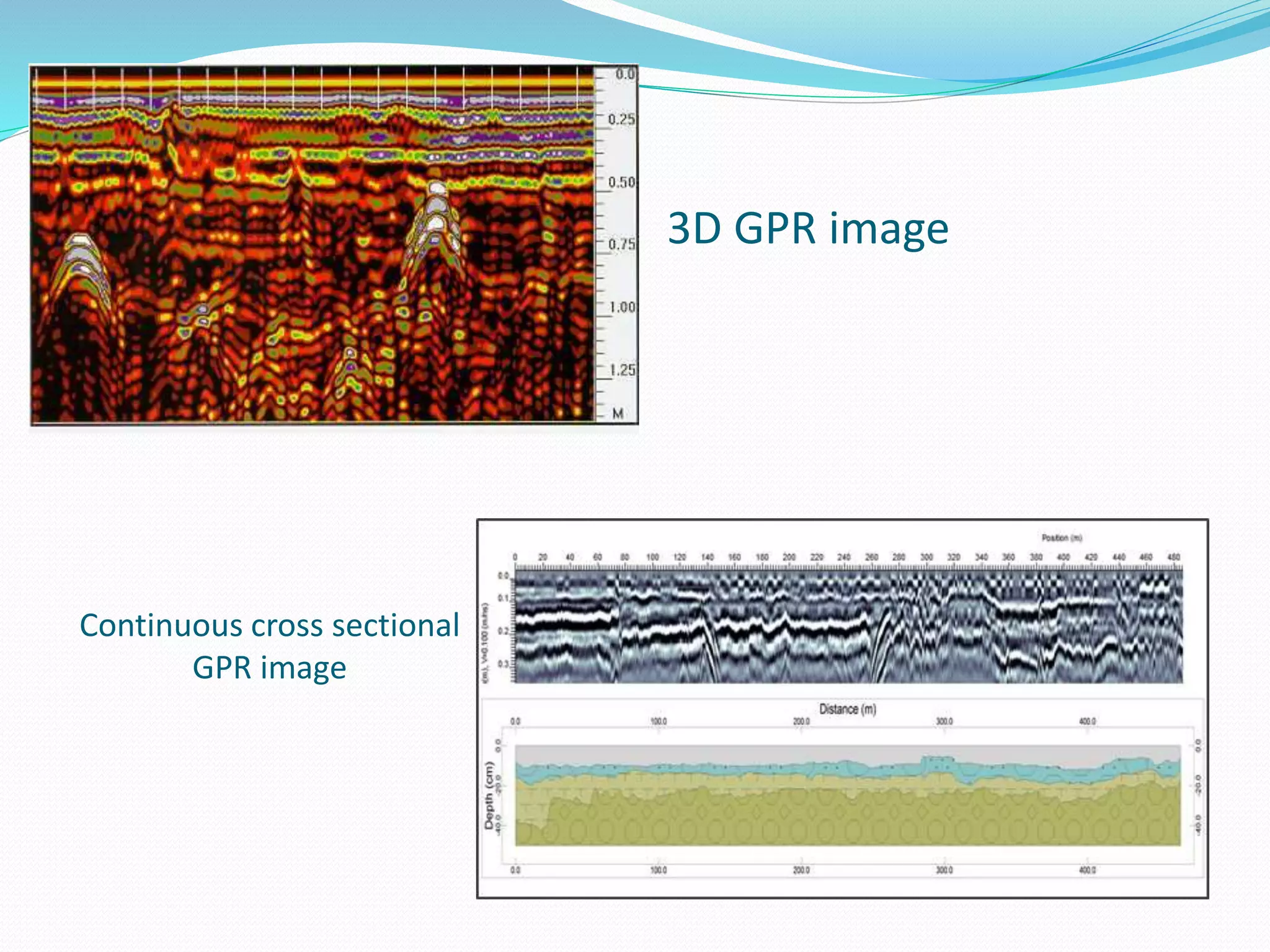
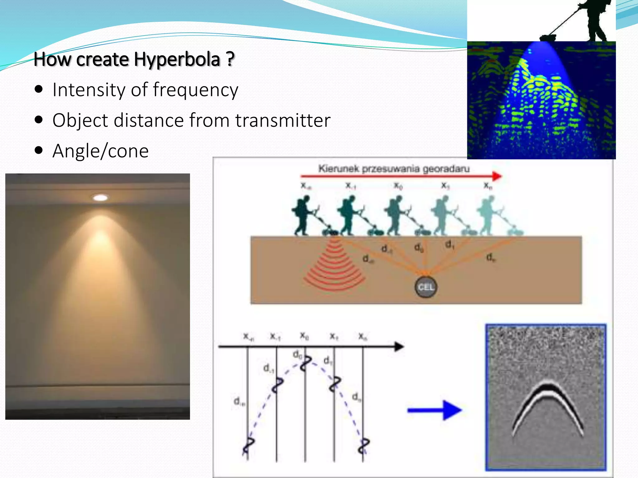
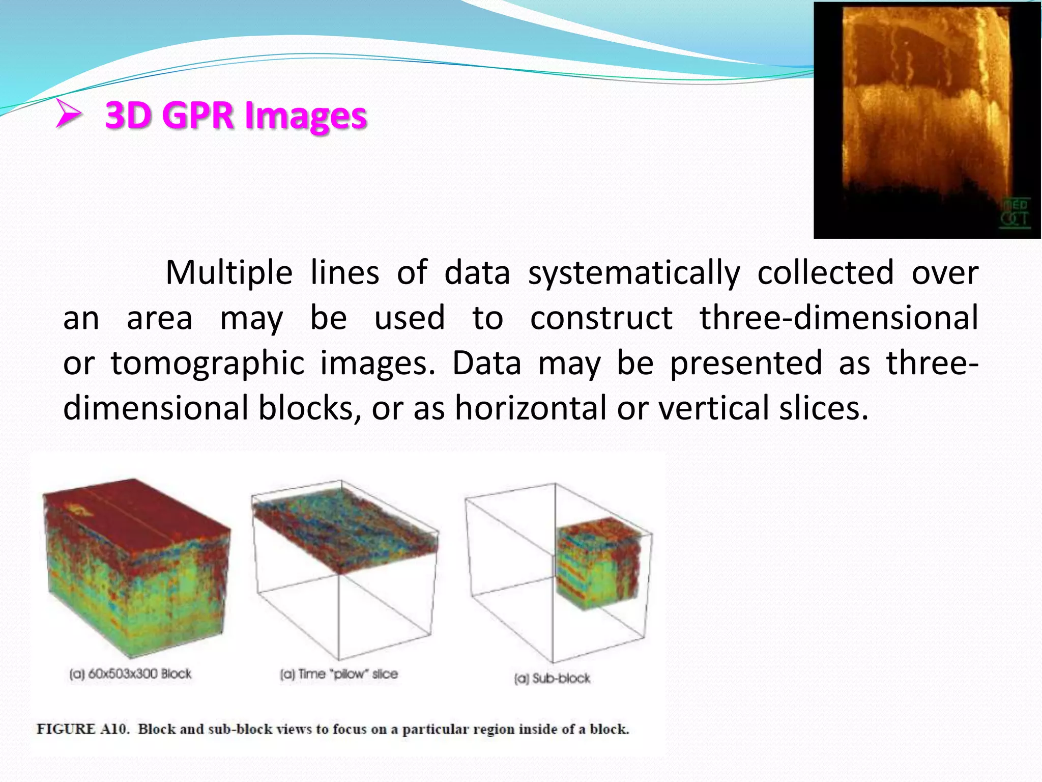
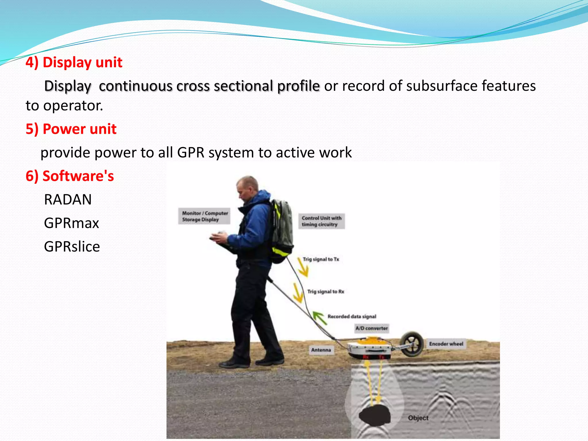
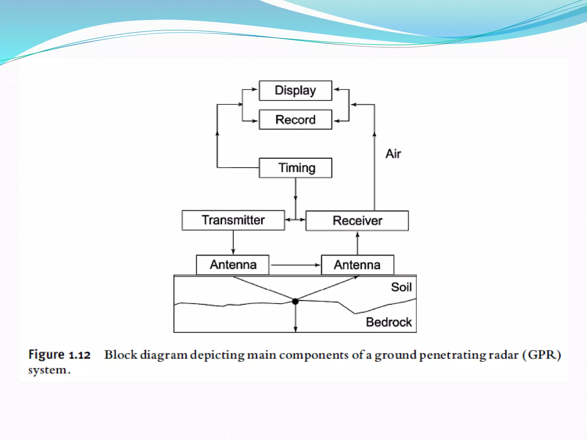
SlideShare a Scribd company logo
Presented by,
Patil Abhijit Sambhaji
M.tech (Geoinformatics) GIS1519
Bharathidasan University, Trichy-24
Subject-
Topic Name-
“Ground Penetrating Radar”
(Principle and Components)
Advance Geospatial Technology
Content
 Introduction
 What is GPR?
 Brief History of GPR
 Principles of GPR
* How its works
* Operating Frequency
* Resolution depend on frequency
* How Deep Can It Go?
* Hyperbola
 Component of GPR
 Advantages/Disadvantages
 Conclusion
Introduction:-
Today, the advance space technology almost reached on extraterrestrial
(Mars) planet and deep ocean exploration also possible to human using
submarine technologies like sonar, scuba diving etc.
But sill today human have no proper answer what are actually below us?
Using direct investigation like bore wells and mining's can provide information
regarding to underground objects with some depth limitations. But using
electromagnetic waves we can get some 100s of meter information regarding
underground objects.
Ground Penetrating Radar (GPR) is one of those techniques which used
radar waves to exploration of underground surface. It can be helpful to many
mapping application with some extent of depth.
What is GPR?
Ground penetrating radar (GPR) is now a well-accepted geophysical
technique. It is a high resolution electromagnetic technique that is designed
primarily to investigate underground surface.
GPR has been developed over the past thirty years for shallow, high
resolution investigations of the subsurface. GPR is a time-dependent
geophysical technique that can provide a 3-D pseudo image of the subsurface,
including the fourth dimension of color, and can also provide accurate depth
estimates for many common subsurface objects. GPR can provide precise
information concerning the nature of buried objects. It produces a continuous
cross-sectional profile or record of subsurface features, without drilling,
probing, or digging.
3D GPR image
Continuous cross sectional
GPR image
Brief History of GPR-
 Foundation for radar systems by Christian Hülsmeyer in 1904
 Gotthelf Leimbach and Heinrich Löwy applied for a patent to use radar
technology to locate buried objects with radar technology in 1910
 A glacier's depth was measured using ground penetrating radar in 1929
by W. Stern
 Military applications began driving research in 1970s
 Commercial applications began in 1985
 GPR is becoming the new tool in archaeological remote sensing & many
other areas.
 The particular invention improved the depth resolution and is still widely
used today.
 Principles of GPR
 How it works ?
 Ground Penetrating Radar (GPR) uses the same fundamental physical principles
as conventional radar. It uses radio waves to map structure and features buries in the
ground /man-made structures. The pulses always propagates in a shape of a cone.
The radar technique principally detect back-scattered energy from a target.
 GPR uses a high frequency radio signal that is transmitted by the antenna and
travels downward until it hits an object that has different electrical properties from
the surrounding medium then its get scattered from the object and receive by the
receiver antenna and stored on digital media. The computer measures the time taken
for a pulse to travel from the target which indicates its depth and location. The
reflected signals are interpreted by the system and displayed on the unit's LCD panel
in the form of cross-sectional profile .
 If the wave hits a buried object, then part of the waves energy is
reflected back to the surface, while part of its energy continues to travel
downward. The wave that is reflected back to the surface is captured by a
receive antenna, and recorded on a digital storage device for later
interpretation. The GPR method measures the travel time of
electromagnetic impulses in subsurface materials.
Antenna is able to detect and measure the depth of reflecting discontinuities
in subsurface.
Cont...
 Operating Frequency
 There is an optimum choice of frequency of operation to achieve
best performance in terms of depth and ability to see details in the
target structure. This choice is between 1 and 5000 MHz. Generally low
frequencies are used for deep probing (>50 m) and high frequencies are
used for shallow probing (<50 m).
 The initial frequency estimation formula:
X-specify a desire spatial resolution
K - relative permittivity (dielectric constant) of most material
 Resolution (depend on Frequency)
 Low frequencies (a few MHz) give good depth penetration, but low
resolution ( more than 50 m).
 High frequencies (about a GHz) can resolve cm-sized objects, but
penetrate only a meter or less in many materials ( less than 50 m).
 In archaeology, resolution is generally more important than depth, so
high frequencies are commonly used.
 In geologic survey, depth is generally more important than resolution,
so low frequency are used to survey.
 How Deep Can It Go?
For applications requiring higher
resolution, such as locating conduits in
concrete, a higher frequency GPR system
(1,000 MHz) is used. This will give high
resolution detail for down to approximately
24 inches in depth. Applications which
require deeper penetration in ground soil
requires a lower frequency (12.5 MHz to 500
MHz). Depending on the subsurface material
the depth range can be from a few inches to
thousands of feet (as indicated in the chart).
dielectric constant
 Hyperbola
 The GPR image shows buried objects in a hyperbolic shape; the top
of the hyperbola represents the exact location of buried object. It is
a well known fact that GPR images are obtained by using a single
radio-wave frequency
 Regular radar image interpreters decide the exact location and
depth of targets depending on a direct distance measurement from
the top of the hyperbola
How create Hyperbola ?
 Intensity of frequency
 Object distance from transmitter
 Angle/cone
 3D GPR Images
Multiple lines of data systematically collected over
an area may be used to construct three-dimensional
or tomographic images. Data may be presented as three-
dimensional blocks, or as horizontal or vertical slices.
Components of GPR
1) Transmitter Antenna
The GPR transmitter produces the short duration high-power RF pulses
of energy that are radiated into ground by the antenna.
2) Receiver Antenna
The GPR receiver receive reflected/backscattered RF pulses of energy
from the object which are located in beneath the ground.
As a general rule, the frequency of the antenna determines the depth
of penetration and the resolution – the higher the frequency the better the
resolution but at the expense of the depth of penetration.
3) The Control unit
The Control unit is the brain center for the GPR system and is
responsible for coordinating the operation of the subordinate components.
It has ability to control all functions of GPR and it is one of the main junction
of data flow.
4) Display unit
Display continuous cross sectional profile or record of subsurface features
to operator.
5) Power unit
provide power to all GPR system to active work
6) Software's
RADAN
GPRmax
GPRslice
 Advantages of GPR
 high speed recording (8km/hr)
 Able to detect voids and trenches
 Able to determine depths and lengths of targets
 Colors also improve data quality
 Easy to handle
 Changeable frequency (1 mhz 5 ghz)
 Real time display unit represent cross sectional profile
 Used in lot of applications
 Disadvantages of GPR
 Higher frequencies do not penetrate as far as lower frequencies
(penetration is limited )
 Doesn't work well in clay
 Terrain must be flat and even
 Interpretation of radargrams is generally complex
 Cellular telephones, two-way radios, television, and radio and
microwave transmitters may cause noise on GPR record
 Highly expensive survey method
 Brief overview of Application of GPR
To find out underground utilities
Mapping Groundwater Table
Archeological survey
Mapping Karst Features
Sinkhole surveys
Geological & Geophysical studies
Concrete inspection
Locating trenches and landfills
Forensic & security
Underground tank storage location
 Conclusion
GPR has been developed into a sophisticated technique that can
provide detailed images of the near surface. GPR is a time-dependent
geophysical technique that can provide a 3-D pseudo image of the
subsurface, including the fourth dimension of color. It can also provide
accurate information of depth estimation for many common subsurface
objects.
In the field of Earth science, it used to study bedrock, soils,
groundwater, and ice depth estimation. GPR is an excellent tool for
mapping underground surface of the earth in recent geological and
geophysical studies.
 References:-
 Ground penetrating radar – theory and application-Harry.M. Jol
 Ground Penetrating Radar Fundamentals by Jeffrey J. Daniels
Online reference sites-
 http://www.global-gpr.com/gpr-technology/how-gpr-works.html
 http://www.geo-radar.pl/en/methods/georadar/working/
 http://undergroundsurveying.com/technology/ground-penetrating-radar-gpr/
 http://geomodel.com/methods/ground-penetrating-radar/
Ground Penetrating Radar (GPR)

More Related Content

What's hot

Gpr seminar by emmaual
Gpr seminar by emmaualGpr seminar by emmaual
Gpr seminar by emmaual
emmanualroy
 
Geophysical studies
Geophysical studiesGeophysical studies
Geophysical studies
Dr. M Prasad
 
Ground Penetrating Radar Survey
Ground Penetrating Radar Survey Ground Penetrating Radar Survey
Ground Penetrating Radar Survey
SSudhaVelan
 
Gravity & magnetic methods in geology
Gravity & magnetic methods in geologyGravity & magnetic methods in geology
Gravity & magnetic methods in geology
Md Asif Hasan
 
Lidar final ppt
Lidar final pptLidar final ppt
Lidar final ppt
rsarnagat
 
REMOTE SENSING
REMOTE SENSINGREMOTE SENSING
REMOTE SENSING
KANNAN
 
Ground penetrating radar (nio)
Ground penetrating radar (nio)Ground penetrating radar (nio)
Ground penetrating radar (nio)
Sabna Thilakan
 
Introduction to Seismic Method
Introduction to Seismic Method Introduction to Seismic Method
Introduction to Seismic Method
Ahmed Younhais Tariq
 
Persentation on magnetometer
Persentation on magnetometerPersentation on magnetometer
Persentation on magnetometer
Engr. Ijaz Ul Haq
 
Gravity and magmetic method
Gravity and magmetic methodGravity and magmetic method
Gravity and magmetic method
Shah Naseer
 
Gravity method
Gravity method Gravity method
Gravity method
Tahsin Islam Ornee
 
Gravity Method
Gravity MethodGravity Method
Gravity Method
Tahsin Islam Ornee
 
Reflecting method of seismic prospecting
Reflecting method of seismic  prospectingReflecting method of seismic  prospecting
Reflecting method of seismic prospecting
Pramoda Raj
 
Resistivity Survey
Resistivity SurveyResistivity Survey
Resistivity Survey
Amit K. Mishra
 
Basics of Remote Sensing
Basics of Remote SensingBasics of Remote Sensing
Basics of Remote Sensing
Akash Tikhe
 
Electrical method
Electrical methodElectrical method
Electrical method
mahmudulhassan123
 
identification of ground water potential zones using gis and remote sensing
identification of ground water potential zones using gis and remote sensingidentification of ground water potential zones using gis and remote sensing
identification of ground water potential zones using gis and remote sensing
tp jayamohan
 
Geophysical exploration
Geophysical explorationGeophysical exploration
Geophysical exploration
Abhineet Godayal CE
 
IDENTIFICATION OF GROUNDWATER POTENTIAL ZONES USING REMOTE SENSING AND GEOGRA...
IDENTIFICATION OF GROUNDWATER POTENTIAL ZONES USING REMOTE SENSING AND GEOGRA...IDENTIFICATION OF GROUNDWATER POTENTIAL ZONES USING REMOTE SENSING AND GEOGRA...
IDENTIFICATION OF GROUNDWATER POTENTIAL ZONES USING REMOTE SENSING AND GEOGRA...
IAEME Publication
 
Geophysical methods brief summary
Geophysical methods brief summaryGeophysical methods brief summary
Geophysical methods brief summary
Jyoti Khatiwada
 

What's hot (20)

Gpr seminar by emmaual
Gpr seminar by emmaualGpr seminar by emmaual
Gpr seminar by emmaual
 
Geophysical studies
Geophysical studiesGeophysical studies
Geophysical studies
 
Ground Penetrating Radar Survey
Ground Penetrating Radar Survey Ground Penetrating Radar Survey
Ground Penetrating Radar Survey
 
Gravity & magnetic methods in geology
Gravity & magnetic methods in geologyGravity & magnetic methods in geology
Gravity & magnetic methods in geology
 
Lidar final ppt
Lidar final pptLidar final ppt
Lidar final ppt
 
REMOTE SENSING
REMOTE SENSINGREMOTE SENSING
REMOTE SENSING
 
Ground penetrating radar (nio)
Ground penetrating radar (nio)Ground penetrating radar (nio)
Ground penetrating radar (nio)
 
Introduction to Seismic Method
Introduction to Seismic Method Introduction to Seismic Method
Introduction to Seismic Method
 
Persentation on magnetometer
Persentation on magnetometerPersentation on magnetometer
Persentation on magnetometer
 
Gravity and magmetic method
Gravity and magmetic methodGravity and magmetic method
Gravity and magmetic method
 
Gravity method
Gravity method Gravity method
Gravity method
 
Gravity Method
Gravity MethodGravity Method
Gravity Method
 
Reflecting method of seismic prospecting
Reflecting method of seismic  prospectingReflecting method of seismic  prospecting
Reflecting method of seismic prospecting
 
Resistivity Survey
Resistivity SurveyResistivity Survey
Resistivity Survey
 
Basics of Remote Sensing
Basics of Remote SensingBasics of Remote Sensing
Basics of Remote Sensing
 
Electrical method
Electrical methodElectrical method
Electrical method
 
identification of ground water potential zones using gis and remote sensing
identification of ground water potential zones using gis and remote sensingidentification of ground water potential zones using gis and remote sensing
identification of ground water potential zones using gis and remote sensing
 
Geophysical exploration
Geophysical explorationGeophysical exploration
Geophysical exploration
 
IDENTIFICATION OF GROUNDWATER POTENTIAL ZONES USING REMOTE SENSING AND GEOGRA...
IDENTIFICATION OF GROUNDWATER POTENTIAL ZONES USING REMOTE SENSING AND GEOGRA...IDENTIFICATION OF GROUNDWATER POTENTIAL ZONES USING REMOTE SENSING AND GEOGRA...
IDENTIFICATION OF GROUNDWATER POTENTIAL ZONES USING REMOTE SENSING AND GEOGRA...
 
Geophysical methods brief summary
Geophysical methods brief summaryGeophysical methods brief summary
Geophysical methods brief summary
 

Similar to Ground Penetrating Radar (GPR)

A Brief Overview of Ground-penetrating radar
A Brief Overview of Ground-penetrating radarA Brief Overview of Ground-penetrating radar
A Brief Overview of Ground-penetrating radar
Advanced Infrastructure Mapping, LLC
 
ground penetrating radar
ground penetrating radarground penetrating radar
ground penetrating radar
Gauravate
 
Landmines Detection
Landmines DetectionLandmines Detection
Landmines Detection
kulrao
 
Ground Penetrating Radar Scanning Unveiling The Secrets Beneath Our Feet
Ground Penetrating Radar Scanning Unveiling The Secrets Beneath Our FeetGround Penetrating Radar Scanning Unveiling The Secrets Beneath Our Feet
Ground Penetrating Radar Scanning Unveiling The Secrets Beneath Our Feet
Tec
 
Land mine ppt
Land mine pptLand mine ppt
Land mine ppt
NikithaReddy88
 
Ground Penetrating Radar Scanning An Introduction to the Technology and its A...
Ground Penetrating Radar Scanning An Introduction to the Technology and its A...Ground Penetrating Radar Scanning An Introduction to the Technology and its A...
Ground Penetrating Radar Scanning An Introduction to the Technology and its A...
Tec
 
Ground Penetrating Radar in CA – How does it work
Ground Penetrating Radar in CA – How does it workGround Penetrating Radar in CA – How does it work
Ground Penetrating Radar in CA – How does it work
Tec
 
Application of Ground Penetrating Radar (GPR) In Detecting Target of Interest
Application of Ground Penetrating Radar (GPR) In Detecting Target of InterestApplication of Ground Penetrating Radar (GPR) In Detecting Target of Interest
Application of Ground Penetrating Radar (GPR) In Detecting Target of Interest
IRJET Journal
 
Introduction-to-Ground-Penetrating-Radar-GPR.pptx
Introduction-to-Ground-Penetrating-Radar-GPR.pptxIntroduction-to-Ground-Penetrating-Radar-GPR.pptx
Introduction-to-Ground-Penetrating-Radar-GPR.pptx
ElvanFisika
 
UWB Radar Technologies for Tunnel Detection
UWB Radar Technologies for Tunnel DetectionUWB Radar Technologies for Tunnel Detection
UWB Radar Technologies for Tunnel DetectionSergey Bondarenko
 
GPR Survey .pdf
GPR Survey .pdfGPR Survey .pdf
GPR Survey .pdf
NeerajMudgil1
 
Gpr survey
Gpr survey Gpr survey
Gpr survey
NeerajMudgil1
 
GPR Survey
GPR Survey GPR Survey
GPR Survey
NeerajMudgil1
 
GPR Survey | Ground Penetrating Radar Survey
GPR Survey | Ground Penetrating Radar SurveyGPR Survey | Ground Penetrating Radar Survey
GPR Survey | Ground Penetrating Radar Survey
NeerajMudgil1
 
GPR Survey
GPR SurveyGPR Survey
GPR Survey
NeerajMudgil1
 
GPR Survey .pdf
GPR Survey .pdfGPR Survey .pdf
GPR Survey .pdf
nxlogydigital
 
GPR Survey .pdf
GPR Survey .pdfGPR Survey .pdf
GPR Survey .pdf
nxlogydigital
 
Gpr survey
Gpr survey Gpr survey
Gpr survey
NeerajMudgil1
 
Gpr survey
Gpr survey Gpr survey
Gpr survey
NeerajMudgil1
 

Similar to Ground Penetrating Radar (GPR) (20)

A Brief Overview of Ground-penetrating radar
A Brief Overview of Ground-penetrating radarA Brief Overview of Ground-penetrating radar
A Brief Overview of Ground-penetrating radar
 
ground penetrating radar
ground penetrating radarground penetrating radar
ground penetrating radar
 
Landmines Detection
Landmines DetectionLandmines Detection
Landmines Detection
 
Ground Penetrating Radar Scanning Unveiling The Secrets Beneath Our Feet
Ground Penetrating Radar Scanning Unveiling The Secrets Beneath Our FeetGround Penetrating Radar Scanning Unveiling The Secrets Beneath Our Feet
Ground Penetrating Radar Scanning Unveiling The Secrets Beneath Our Feet
 
Land mine ppt
Land mine pptLand mine ppt
Land mine ppt
 
Ground Penetrating Radar Scanning An Introduction to the Technology and its A...
Ground Penetrating Radar Scanning An Introduction to the Technology and its A...Ground Penetrating Radar Scanning An Introduction to the Technology and its A...
Ground Penetrating Radar Scanning An Introduction to the Technology and its A...
 
Ground Penetrating Radar in CA – How does it work
Ground Penetrating Radar in CA – How does it workGround Penetrating Radar in CA – How does it work
Ground Penetrating Radar in CA – How does it work
 
Application of Ground Penetrating Radar (GPR) In Detecting Target of Interest
Application of Ground Penetrating Radar (GPR) In Detecting Target of InterestApplication of Ground Penetrating Radar (GPR) In Detecting Target of Interest
Application of Ground Penetrating Radar (GPR) In Detecting Target of Interest
 
Introduction-to-Ground-Penetrating-Radar-GPR.pptx
Introduction-to-Ground-Penetrating-Radar-GPR.pptxIntroduction-to-Ground-Penetrating-Radar-GPR.pptx
Introduction-to-Ground-Penetrating-Radar-GPR.pptx
 
MABE08
MABE08MABE08
MABE08
 
UWB Radar Technologies for Tunnel Detection
UWB Radar Technologies for Tunnel DetectionUWB Radar Technologies for Tunnel Detection
UWB Radar Technologies for Tunnel Detection
 
GPR Survey .pdf
GPR Survey .pdfGPR Survey .pdf
GPR Survey .pdf
 
Gpr survey
Gpr survey Gpr survey
Gpr survey
 
GPR Survey
GPR Survey GPR Survey
GPR Survey
 
GPR Survey | Ground Penetrating Radar Survey
GPR Survey | Ground Penetrating Radar SurveyGPR Survey | Ground Penetrating Radar Survey
GPR Survey | Ground Penetrating Radar Survey
 
GPR Survey
GPR SurveyGPR Survey
GPR Survey
 
GPR Survey .pdf
GPR Survey .pdfGPR Survey .pdf
GPR Survey .pdf
 
GPR Survey .pdf
GPR Survey .pdfGPR Survey .pdf
GPR Survey .pdf
 
Gpr survey
Gpr survey Gpr survey
Gpr survey
 
Gpr survey
Gpr survey Gpr survey
Gpr survey
 

Recently uploaded

Epistemic Interaction - tuning interfaces to provide information for AI support
Epistemic Interaction - tuning interfaces to provide information for AI supportEpistemic Interaction - tuning interfaces to provide information for AI support
Epistemic Interaction - tuning interfaces to provide information for AI support
Alan Dix
 
Designing Great Products: The Power of Design and Leadership by Chief Designe...
Designing Great Products: The Power of Design and Leadership by Chief Designe...Designing Great Products: The Power of Design and Leadership by Chief Designe...
Designing Great Products: The Power of Design and Leadership by Chief Designe...
Product School
 
UiPath Test Automation using UiPath Test Suite series, part 4
UiPath Test Automation using UiPath Test Suite series, part 4UiPath Test Automation using UiPath Test Suite series, part 4
UiPath Test Automation using UiPath Test Suite series, part 4
DianaGray10
 
Monitoring Java Application Security with JDK Tools and JFR Events
Monitoring Java Application Security with JDK Tools and JFR EventsMonitoring Java Application Security with JDK Tools and JFR Events
Monitoring Java Application Security with JDK Tools and JFR Events
Ana-Maria Mihalceanu
 
Generating a custom Ruby SDK for your web service or Rails API using Smithy
Generating a custom Ruby SDK for your web service or Rails API using SmithyGenerating a custom Ruby SDK for your web service or Rails API using Smithy
Generating a custom Ruby SDK for your web service or Rails API using Smithy
g2nightmarescribd
 
Assuring Contact Center Experiences for Your Customers With ThousandEyes
Assuring Contact Center Experiences for Your Customers With ThousandEyesAssuring Contact Center Experiences for Your Customers With ThousandEyes
Assuring Contact Center Experiences for Your Customers With ThousandEyes
ThousandEyes
 
UiPath Test Automation using UiPath Test Suite series, part 3
UiPath Test Automation using UiPath Test Suite series, part 3UiPath Test Automation using UiPath Test Suite series, part 3
UiPath Test Automation using UiPath Test Suite series, part 3
DianaGray10
 
FIDO Alliance Osaka Seminar: Overview.pdf
FIDO Alliance Osaka Seminar: Overview.pdfFIDO Alliance Osaka Seminar: Overview.pdf
FIDO Alliance Osaka Seminar: Overview.pdf
FIDO Alliance
 
Smart TV Buyer Insights Survey 2024 by 91mobiles.pdf
Smart TV Buyer Insights Survey 2024 by 91mobiles.pdfSmart TV Buyer Insights Survey 2024 by 91mobiles.pdf
Smart TV Buyer Insights Survey 2024 by 91mobiles.pdf
91mobiles
 
Key Trends Shaping the Future of Infrastructure.pdf
Key Trends Shaping the Future of Infrastructure.pdfKey Trends Shaping the Future of Infrastructure.pdf
Key Trends Shaping the Future of Infrastructure.pdf
Cheryl Hung
 
Accelerate your Kubernetes clusters with Varnish Caching
Accelerate your Kubernetes clusters with Varnish CachingAccelerate your Kubernetes clusters with Varnish Caching
Accelerate your Kubernetes clusters with Varnish Caching
Thijs Feryn
 
When stars align: studies in data quality, knowledge graphs, and machine lear...
When stars align: studies in data quality, knowledge graphs, and machine lear...When stars align: studies in data quality, knowledge graphs, and machine lear...
When stars align: studies in data quality, knowledge graphs, and machine lear...
Elena Simperl
 
PCI PIN Basics Webinar from the Controlcase Team
PCI PIN Basics Webinar from the Controlcase TeamPCI PIN Basics Webinar from the Controlcase Team
PCI PIN Basics Webinar from the Controlcase Team
ControlCase
 
Dev Dives: Train smarter, not harder – active learning and UiPath LLMs for do...
Dev Dives: Train smarter, not harder – active learning and UiPath LLMs for do...Dev Dives: Train smarter, not harder – active learning and UiPath LLMs for do...
Dev Dives: Train smarter, not harder – active learning and UiPath LLMs for do...
UiPathCommunity
 
Leading Change strategies and insights for effective change management pdf 1.pdf
Leading Change strategies and insights for effective change management pdf 1.pdfLeading Change strategies and insights for effective change management pdf 1.pdf
Leading Change strategies and insights for effective change management pdf 1.pdf
OnBoard
 
Software Delivery At the Speed of AI: Inflectra Invests In AI-Powered Quality
Software Delivery At the Speed of AI: Inflectra Invests In AI-Powered QualitySoftware Delivery At the Speed of AI: Inflectra Invests In AI-Powered Quality
Software Delivery At the Speed of AI: Inflectra Invests In AI-Powered Quality
Inflectra
 
From Daily Decisions to Bottom Line: Connecting Product Work to Revenue by VP...
From Daily Decisions to Bottom Line: Connecting Product Work to Revenue by VP...From Daily Decisions to Bottom Line: Connecting Product Work to Revenue by VP...
From Daily Decisions to Bottom Line: Connecting Product Work to Revenue by VP...
Product School
 
Bits & Pixels using AI for Good.........
Bits & Pixels using AI for Good.........Bits & Pixels using AI for Good.........
Bits & Pixels using AI for Good.........
Alison B. Lowndes
 
Unsubscribed: Combat Subscription Fatigue With a Membership Mentality by Head...
Unsubscribed: Combat Subscription Fatigue With a Membership Mentality by Head...Unsubscribed: Combat Subscription Fatigue With a Membership Mentality by Head...
Unsubscribed: Combat Subscription Fatigue With a Membership Mentality by Head...
Product School
 
De-mystifying Zero to One: Design Informed Techniques for Greenfield Innovati...
De-mystifying Zero to One: Design Informed Techniques for Greenfield Innovati...De-mystifying Zero to One: Design Informed Techniques for Greenfield Innovati...
De-mystifying Zero to One: Design Informed Techniques for Greenfield Innovati...
Product School
 

Recently uploaded (20)

Epistemic Interaction - tuning interfaces to provide information for AI support
Epistemic Interaction - tuning interfaces to provide information for AI supportEpistemic Interaction - tuning interfaces to provide information for AI support
Epistemic Interaction - tuning interfaces to provide information for AI support
 
Designing Great Products: The Power of Design and Leadership by Chief Designe...
Designing Great Products: The Power of Design and Leadership by Chief Designe...Designing Great Products: The Power of Design and Leadership by Chief Designe...
Designing Great Products: The Power of Design and Leadership by Chief Designe...
 
UiPath Test Automation using UiPath Test Suite series, part 4
UiPath Test Automation using UiPath Test Suite series, part 4UiPath Test Automation using UiPath Test Suite series, part 4
UiPath Test Automation using UiPath Test Suite series, part 4
 
Monitoring Java Application Security with JDK Tools and JFR Events
Monitoring Java Application Security with JDK Tools and JFR EventsMonitoring Java Application Security with JDK Tools and JFR Events
Monitoring Java Application Security with JDK Tools and JFR Events
 
Generating a custom Ruby SDK for your web service or Rails API using Smithy
Generating a custom Ruby SDK for your web service or Rails API using SmithyGenerating a custom Ruby SDK for your web service or Rails API using Smithy
Generating a custom Ruby SDK for your web service or Rails API using Smithy
 
Assuring Contact Center Experiences for Your Customers With ThousandEyes
Assuring Contact Center Experiences for Your Customers With ThousandEyesAssuring Contact Center Experiences for Your Customers With ThousandEyes
Assuring Contact Center Experiences for Your Customers With ThousandEyes
 
UiPath Test Automation using UiPath Test Suite series, part 3
UiPath Test Automation using UiPath Test Suite series, part 3UiPath Test Automation using UiPath Test Suite series, part 3
UiPath Test Automation using UiPath Test Suite series, part 3
 
FIDO Alliance Osaka Seminar: Overview.pdf
FIDO Alliance Osaka Seminar: Overview.pdfFIDO Alliance Osaka Seminar: Overview.pdf
FIDO Alliance Osaka Seminar: Overview.pdf
 
Smart TV Buyer Insights Survey 2024 by 91mobiles.pdf
Smart TV Buyer Insights Survey 2024 by 91mobiles.pdfSmart TV Buyer Insights Survey 2024 by 91mobiles.pdf
Smart TV Buyer Insights Survey 2024 by 91mobiles.pdf
 
Key Trends Shaping the Future of Infrastructure.pdf
Key Trends Shaping the Future of Infrastructure.pdfKey Trends Shaping the Future of Infrastructure.pdf
Key Trends Shaping the Future of Infrastructure.pdf
 
Accelerate your Kubernetes clusters with Varnish Caching
Accelerate your Kubernetes clusters with Varnish CachingAccelerate your Kubernetes clusters with Varnish Caching
Accelerate your Kubernetes clusters with Varnish Caching
 
When stars align: studies in data quality, knowledge graphs, and machine lear...
When stars align: studies in data quality, knowledge graphs, and machine lear...When stars align: studies in data quality, knowledge graphs, and machine lear...
When stars align: studies in data quality, knowledge graphs, and machine lear...
 
PCI PIN Basics Webinar from the Controlcase Team
PCI PIN Basics Webinar from the Controlcase TeamPCI PIN Basics Webinar from the Controlcase Team
PCI PIN Basics Webinar from the Controlcase Team
 
Dev Dives: Train smarter, not harder – active learning and UiPath LLMs for do...
Dev Dives: Train smarter, not harder – active learning and UiPath LLMs for do...Dev Dives: Train smarter, not harder – active learning and UiPath LLMs for do...
Dev Dives: Train smarter, not harder – active learning and UiPath LLMs for do...
 
Leading Change strategies and insights for effective change management pdf 1.pdf
Leading Change strategies and insights for effective change management pdf 1.pdfLeading Change strategies and insights for effective change management pdf 1.pdf
Leading Change strategies and insights for effective change management pdf 1.pdf
 
Software Delivery At the Speed of AI: Inflectra Invests In AI-Powered Quality
Software Delivery At the Speed of AI: Inflectra Invests In AI-Powered QualitySoftware Delivery At the Speed of AI: Inflectra Invests In AI-Powered Quality
Software Delivery At the Speed of AI: Inflectra Invests In AI-Powered Quality
 
From Daily Decisions to Bottom Line: Connecting Product Work to Revenue by VP...
From Daily Decisions to Bottom Line: Connecting Product Work to Revenue by VP...From Daily Decisions to Bottom Line: Connecting Product Work to Revenue by VP...
From Daily Decisions to Bottom Line: Connecting Product Work to Revenue by VP...
 
Bits & Pixels using AI for Good.........
Bits & Pixels using AI for Good.........Bits & Pixels using AI for Good.........
Bits & Pixels using AI for Good.........
 
Unsubscribed: Combat Subscription Fatigue With a Membership Mentality by Head...
Unsubscribed: Combat Subscription Fatigue With a Membership Mentality by Head...Unsubscribed: Combat Subscription Fatigue With a Membership Mentality by Head...
Unsubscribed: Combat Subscription Fatigue With a Membership Mentality by Head...
 
De-mystifying Zero to One: Design Informed Techniques for Greenfield Innovati...
De-mystifying Zero to One: Design Informed Techniques for Greenfield Innovati...De-mystifying Zero to One: Design Informed Techniques for Greenfield Innovati...
De-mystifying Zero to One: Design Informed Techniques for Greenfield Innovati...
 

Ground Penetrating Radar (GPR)

  • 1. Presented by, Patil Abhijit Sambhaji M.tech (Geoinformatics) GIS1519 Bharathidasan University, Trichy-24 Subject- Topic Name- “Ground Penetrating Radar” (Principle and Components) Advance Geospatial Technology
  • 2. Content  Introduction  What is GPR?  Brief History of GPR  Principles of GPR * How its works * Operating Frequency * Resolution depend on frequency * How Deep Can It Go? * Hyperbola  Component of GPR  Advantages/Disadvantages  Conclusion
  • 3. Introduction:- Today, the advance space technology almost reached on extraterrestrial (Mars) planet and deep ocean exploration also possible to human using submarine technologies like sonar, scuba diving etc. But sill today human have no proper answer what are actually below us? Using direct investigation like bore wells and mining's can provide information regarding to underground objects with some depth limitations. But using electromagnetic waves we can get some 100s of meter information regarding underground objects. Ground Penetrating Radar (GPR) is one of those techniques which used radar waves to exploration of underground surface. It can be helpful to many mapping application with some extent of depth.
  • 4. What is GPR? Ground penetrating radar (GPR) is now a well-accepted geophysical technique. It is a high resolution electromagnetic technique that is designed primarily to investigate underground surface. GPR has been developed over the past thirty years for shallow, high resolution investigations of the subsurface. GPR is a time-dependent geophysical technique that can provide a 3-D pseudo image of the subsurface, including the fourth dimension of color, and can also provide accurate depth estimates for many common subsurface objects. GPR can provide precise information concerning the nature of buried objects. It produces a continuous cross-sectional profile or record of subsurface features, without drilling, probing, or digging.
  • 5. 3D GPR image Continuous cross sectional GPR image
  • 6. Brief History of GPR-  Foundation for radar systems by Christian Hülsmeyer in 1904  Gotthelf Leimbach and Heinrich Löwy applied for a patent to use radar technology to locate buried objects with radar technology in 1910  A glacier's depth was measured using ground penetrating radar in 1929 by W. Stern  Military applications began driving research in 1970s  Commercial applications began in 1985  GPR is becoming the new tool in archaeological remote sensing & many other areas.  The particular invention improved the depth resolution and is still widely used today.
  • 7.  Principles of GPR  How it works ?  Ground Penetrating Radar (GPR) uses the same fundamental physical principles as conventional radar. It uses radio waves to map structure and features buries in the ground /man-made structures. The pulses always propagates in a shape of a cone. The radar technique principally detect back-scattered energy from a target.  GPR uses a high frequency radio signal that is transmitted by the antenna and travels downward until it hits an object that has different electrical properties from the surrounding medium then its get scattered from the object and receive by the receiver antenna and stored on digital media. The computer measures the time taken for a pulse to travel from the target which indicates its depth and location. The reflected signals are interpreted by the system and displayed on the unit's LCD panel in the form of cross-sectional profile .
  • 8.  If the wave hits a buried object, then part of the waves energy is reflected back to the surface, while part of its energy continues to travel downward. The wave that is reflected back to the surface is captured by a receive antenna, and recorded on a digital storage device for later interpretation. The GPR method measures the travel time of electromagnetic impulses in subsurface materials. Antenna is able to detect and measure the depth of reflecting discontinuities in subsurface. Cont...
  • 9.  Operating Frequency  There is an optimum choice of frequency of operation to achieve best performance in terms of depth and ability to see details in the target structure. This choice is between 1 and 5000 MHz. Generally low frequencies are used for deep probing (>50 m) and high frequencies are used for shallow probing (<50 m).  The initial frequency estimation formula: X-specify a desire spatial resolution K - relative permittivity (dielectric constant) of most material
  • 10.  Resolution (depend on Frequency)  Low frequencies (a few MHz) give good depth penetration, but low resolution ( more than 50 m).  High frequencies (about a GHz) can resolve cm-sized objects, but penetrate only a meter or less in many materials ( less than 50 m).  In archaeology, resolution is generally more important than depth, so high frequencies are commonly used.  In geologic survey, depth is generally more important than resolution, so low frequency are used to survey.
  • 11.
  • 12.  How Deep Can It Go? For applications requiring higher resolution, such as locating conduits in concrete, a higher frequency GPR system (1,000 MHz) is used. This will give high resolution detail for down to approximately 24 inches in depth. Applications which require deeper penetration in ground soil requires a lower frequency (12.5 MHz to 500 MHz). Depending on the subsurface material the depth range can be from a few inches to thousands of feet (as indicated in the chart).
  • 15.  The GPR image shows buried objects in a hyperbolic shape; the top of the hyperbola represents the exact location of buried object. It is a well known fact that GPR images are obtained by using a single radio-wave frequency  Regular radar image interpreters decide the exact location and depth of targets depending on a direct distance measurement from the top of the hyperbola
  • 16. How create Hyperbola ?  Intensity of frequency  Object distance from transmitter  Angle/cone
  • 17.  3D GPR Images Multiple lines of data systematically collected over an area may be used to construct three-dimensional or tomographic images. Data may be presented as three- dimensional blocks, or as horizontal or vertical slices.
  • 18. Components of GPR 1) Transmitter Antenna The GPR transmitter produces the short duration high-power RF pulses of energy that are radiated into ground by the antenna. 2) Receiver Antenna The GPR receiver receive reflected/backscattered RF pulses of energy from the object which are located in beneath the ground. As a general rule, the frequency of the antenna determines the depth of penetration and the resolution – the higher the frequency the better the resolution but at the expense of the depth of penetration. 3) The Control unit The Control unit is the brain center for the GPR system and is responsible for coordinating the operation of the subordinate components. It has ability to control all functions of GPR and it is one of the main junction of data flow.
  • 19. 4) Display unit Display continuous cross sectional profile or record of subsurface features to operator. 5) Power unit provide power to all GPR system to active work 6) Software's RADAN GPRmax GPRslice
  • 20.
  • 21.  Advantages of GPR  high speed recording (8km/hr)  Able to detect voids and trenches  Able to determine depths and lengths of targets  Colors also improve data quality  Easy to handle  Changeable frequency (1 mhz 5 ghz)  Real time display unit represent cross sectional profile  Used in lot of applications
  • 22.  Disadvantages of GPR  Higher frequencies do not penetrate as far as lower frequencies (penetration is limited )  Doesn't work well in clay  Terrain must be flat and even  Interpretation of radargrams is generally complex  Cellular telephones, two-way radios, television, and radio and microwave transmitters may cause noise on GPR record  Highly expensive survey method
  • 23.  Brief overview of Application of GPR To find out underground utilities Mapping Groundwater Table Archeological survey Mapping Karst Features Sinkhole surveys Geological & Geophysical studies Concrete inspection Locating trenches and landfills Forensic & security Underground tank storage location
  • 24.  Conclusion GPR has been developed into a sophisticated technique that can provide detailed images of the near surface. GPR is a time-dependent geophysical technique that can provide a 3-D pseudo image of the subsurface, including the fourth dimension of color. It can also provide accurate information of depth estimation for many common subsurface objects. In the field of Earth science, it used to study bedrock, soils, groundwater, and ice depth estimation. GPR is an excellent tool for mapping underground surface of the earth in recent geological and geophysical studies.
  • 25.  References:-  Ground penetrating radar – theory and application-Harry.M. Jol  Ground Penetrating Radar Fundamentals by Jeffrey J. Daniels Online reference sites-  http://www.global-gpr.com/gpr-technology/how-gpr-works.html  http://www.geo-radar.pl/en/methods/georadar/working/  http://undergroundsurveying.com/technology/ground-penetrating-radar-gpr/  http://geomodel.com/methods/ground-penetrating-radar/

Editor's Notes

  1. This is probably one of the most commonly asked questions.