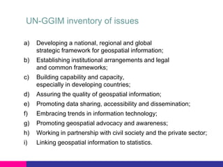
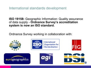
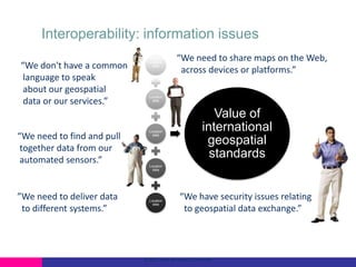
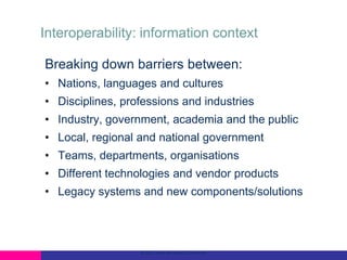
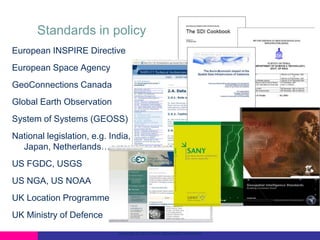
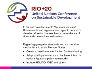
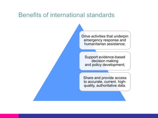
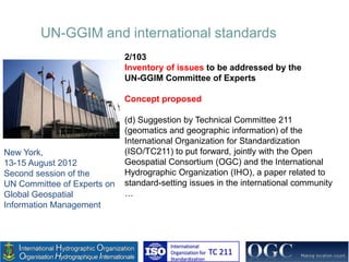
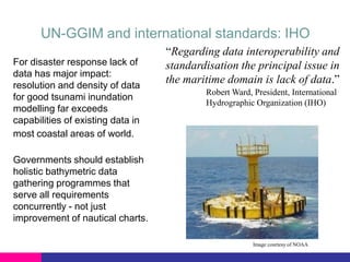
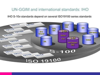
The value of international
geospatial standards

Steven Ramage
Head of Ordnance Survey International
Member of the OGC Global Advisory Council
12 years of OS MasterMap® in GML!

Went live on

30 Nov 2001
Flagship product

First industrial strength GML implementation
460 million features

Updated and supplied on a daily basis
Available in GML only
International standards development
ISO 19158: Geographic Information: Quality assurance
of data supply - Ordnance Survey’s accreditation
system is now an ISO standard.
Ordnance Survey working in collaboration with:
3D-enabled
National Data Model
• Ordnance Survey International partnership for
development of national 3D-enabled data model;
• Ordnance Survey International awarded contract to
develop spatial data models for Kingdom of Bahrain
following open tender process in March 2013;
• Five year strategic advisory services framework
agreement signed in November 2013;
• Vendor and platform independent solutions,
based on international standards.
Interoperability: information issues
“We don't have a common
language to speak
about our geospatial
data or our services.”

“We need to find and pull
together data from our
automated sensors.”

”We need to deliver data
to different systems.”

Location
data

“We need to share maps on the Web,
across devices or platforms.”

Location
data

Location
data

Value of
international
geospatial
standards

Location
data

Location
data

“We have security issues relating
to geospatial data exchange.”

© 2012 Open Geospatial Consortium
Interoperability: information context
Breaking down barriers between:
• Nations, languages and cultures
• Disciplines, professions and industries
• Industry, government, academia and the public
• Local, regional and national government
• Teams, departments, organisations
• Different technologies and vendor products
• Legacy systems and new components/solutions

© 2012 Open Geospatial Consortium
Interoperability: information access
• Technical documents that detail interfaces or encodings;

• Software developers use these documents to build open
interfaces and encodings into their products and services;
• These standards are the main "products" and have been
developed to address specific interoperability challenges;

• Ideally, when standards are implemented in products or
online services by two different software engineers
working independently, the resulting components
plug and play, that is, they work together
without further debugging.

Copyright © 2012 Open Geospatial Consortium
Interoperability: information value
Help policy and decision makers
to address the following:
a) Is the activity for public benefit?
Measure and record value or ROI
b) What is the business driver?
Internal efficiency, customer satisfaction
c) Does a capability already exist?
Enable reuse, avoid duplication

© 2012 Open Geospatial Consortium
Standards in policy
European INSPIRE Directive
European Space Agency
GeoConnections Canada
Global Earth Observation
System of Systems (GEOSS)
National legislation, e.g. India,
Japan, Netherlands…
US FGDC, USGS

US NGA, US NOAA
UK Location Programme
UK Ministry of Defence
Copyright © 2012 Open Geospatial Consortium
UN-GGIM and open standards

In the outcome document “The future we want”
Governments and organisations urged to commit to
disaster risk reduction to enhance the resilience of
cities and communities to disasters.
Regarding geospatial standards we must consider
mechanisms to assist Member States:
• Create a baseline or mechanism for data sharing;
• Adopt existing standards and implement them in
national legal and policy frameworks;
• Include IHO, ISO, OGC and others.
Benefits of international standards

Drive activities that underpin
emergency response and
humanitarian assistance;

Support evidence-based
decision making
and policy development;

Share and provide access
to accurate, current, highquality, authoritative data.
UN-GGIM inventory of issues
a)

Developing a national, regional and global
strategic framework for geospatial information;

b)

Establishing institutional arrangements and legal
and common frameworks;

c)

Building capability and capacity,
especially in developing countries;

d)

Assuring the quality of geospatial information;

e)

Promoting data sharing, accessibility and dissemination;

f)

Embracing trends in information technology;

g)

Promoting geospatial advocacy and awareness;

h)

Working in partnership with civil society and the private sector;

i)

Linking geospatial information to statistics.
UN-GGIM and international standards
2/103
Inventory of issues to be addressed by the
UN-GGIM Committee of Experts
Concept proposed

New York,
13-15 August 2012
Second session of the
UN Committee of Experts on
Global Geospatial
Information Management

(d) Suggestion by Technical Committee 211
(geomatics and geographic information) of the
International Organization for Standardization
(ISO/TC211) to put forward, jointly with the Open
Geospatial Consortium (OGC) and the International
Hydrographic Organization (IHO), a paper related to
standard-setting issues in the international community
…

International
Organization for
Standardization

TC 211
UN-GGIM and international standards
Draft report submitted

Second High Level Forum on Global
Geospatial Information Management
Qatar National Convention
Centre, Doha, Qatar, 4-6 February 2013

Full report
Third Session of UN-GGIM
Committee of Experts
Cambridge, UK,
24-27 July 2013

International
Organization for
Standardization

TC 211
http://tinyurl.com/mmfxjh5
Existing standards and inventory of issues
UN-GGIM Future trends
•

Key trends
•

Cloud computing

•

Linked data

•

Big data

•

Internet of Things

•

New data creation

•

Volunteered Geographic Information

•

Open standards

•

Open source

•

Legal and policy frameworks

•

Data standards and policy

•

Coordination and collaboration

•

Skills and training

http://ggim.un.org/docs/meetings/3rd%20UNCE/UN-GGIM-Future-trends.pdf
International Hydrographic Organization (IHO)
• Intergovernmental consultative and technical
organization established in 1921
• To support safety of navigation and the protection of
the marine environment
• One of the IHO objectives:
 To bring about the greatest possible uniformity in
nautical charts and documents (i.e. standardization)
www.iho.int
UN-GGIM and international standards: IHO
For disaster response lack of
data has major impact:
resolution and density of data
for good tsunami inundation
modelling far exceeds
capabilities of existing data in
most coastal areas of world.

“Regarding data interoperability and
standardisation the principal issue in
the maritime domain is lack of data.”
Robert Ward, President, International
Hydrographic Organization (IHO)

Governments should establish
holistic bathymetric data
gathering programmes that
serve all requirements
concurrently - not just
improvement of nautical charts.
Image courtesy of NOAA
UN-GGIM and international standards: IHO
IHO S-10x standards depend on several ISO19100 series standards

3D &
Temporal

Bathy
ENC

Inland
ENC

S-10x

Web Services

Nautical
Pubs

AML

MIO

S-101
Next Generation

ENC

Gridded
UN-GGIM and international standards: ISO
• World's largest developer of standards founded in 1946
 Network of national standards institutes from 163 countries
 19 500 standards published

• Recognized by the UN, particularly agencies involved in the
harmonization of regulations and public policies, and that
provide assistance and support to developing countries
• Technical Committees (TCs)
 Range from food safety to computers to healthcare
 ISO/TC 211, Geographic information/geomatics

www.iso.org

www.isotc211.org
Components of Spatial Data Infrastructure (SDI)

Standards

Access,
Technology

Content (data)

Organization

Education
UN-GGIM and international standards
ISO/TC 211, OGC and IHO have
.
been cooperating since 1994, mainly
under the liaison mechanism of ISO.

ISO/TC 211 and OGC also benefit
from a range of people working
actively in both organizations and
have a Joint Advisory Group (JAG).
This includes representatives from
Ordnance Survey.
UN-GGIM and international standards: OGC
• Industry consortium, circa 500 member organisations
• 30+ geospatial standards, many also ISO standards

• Goal is to define, document and test implementation
standards for use with geospatial content and services
 integration of geospatial content and services into
applications

www.opengeospatial.org
Standards are like
parachutes: they
work best when
they're open.
Mary McRae, OASIS
WFS for data supply works

Kyle Dow, Senior Data Analyst, Corporate Data Team, CCC
Some issues
 Christchurch City holds

Authoritative Data, e.g…
 WasteWater
 Building Status

 Construction partners manually

submit data in variety of formats
 Time and money wasted on

data loading and management
 WFS has no capability to receive

updates through interoperable web
services
What was needed
 Transactional Interoperability between

recovery partners:
 CERA, CCC, SCIRT
 ESRI, Intergraph
 OGC Standards (NZGO SDI Cookbook)

 Practical, short-term solution (can’t wait)
 Focus on issues with existing (OGC)

standards interfaces, notably WFS-T
 Immediate results that will accelerate

recovery & reconstruction efforts
Solution: WFS-T Plugfest
 Short Duration
 Collaborative
 Hands-on
 Independent Facilitation & WFS-T Architect
 “Just Make it Work”

Image: http://www.ispcs.org
Technology agnostic
Organisation
CCC

Technologies
Intergraph GeoMedia Pro
Intergraph GeoMedia WebMap

SCIRT

ESRI ArcGIS Server
ESRI ArcGIS Desktop
Safe Software – FME
WFS ‘Pump script’

CERA

Benoli Silverfish
ESRI GeoDatabase
WFS ‘Pump script’

InsureCorp*

Pitney Bowes Software MapInfo
Professional

* fictitious name to protect any commercial interests
Before and After
OGC Business Value Committee (BVC)

The goals of the BVC are:
1. Determine the value of using open standards;
2. Assess the business reasons for developing standards;
3. Provide an independent forum for discussion.

business.value@lists.opengeospatial.org
Costs
 Scale: 1-7
 Both technology users and providers expect some costs

associated with OGC standards adoption
 No 1 Costs: employee training
 Overall, technology users expect higher costs than

technology providers
Technology Users
Security/Privacy

Technology Providers
Uncertainty

4.26

Employee Training

2.97

Employee Training

4.86

4.73

Organizational Changes

4.6

Organizational Changes

4.19

Integration Costs

4.42

Integration Costs

4.25

Implementation Costs

4.23

Implementation Costs

4.1
1

36

2

3

4

5

6

Prepared by Kexin Zhao & Mu Xia 2012

7

1

2

3

4

5

6

12/22/2013

7
Benefits
 Scale: 1-7
 Both technology users and providers expect

significant benefits from adopting OGC standards
 No. 1 benefit: better customer service (users) and

customer satisfaction (providers)
Technology Users

Technology Providers

Productivity

5.01

Customer Service

Reduce Development Costs
5.46

Competitive Advantage

Productivity

4.93

Reduce Operating Costs

4.64

Market Expansion

37

2

3

4

5

5.22

Market Expansion

6

Prepared by Kexin Zhao & Mu Xia 2012

7

5.46

Customer Satisfaction

5.35
1

4.98

New Market

4.96

Partner Coordination

5.38

Reduce Operating Costs

4.71

New Market

4.62

Competitive Advantage

5.28

Bargain with IT Vendor

4.94

5.55
1

2

3

4

5

6

12/22/2013

7
BVC motion: form a MENA Regional Forum
• The Business Value Committee recommended that the OGC
Technical Committee approve the Middle East/North Africa
forum charter and requested that the OGC Planning Committee
approve formation of this new proposed OGC Forum.
• The goal for the Middle East and North Africa (MENA) Regional
Forum is to address OGC outreach and education needs of
government, academic, research and industry organizations in
the Middle East and North Africa.
• The MENA Forum charter is available here:
https://portal.opengeospatial.org/files/?artifact_id=52791&version=1

Copyright © 2013 Open Geospatial Consortium
With thanks to the following contributors:
Naji Sabt, Director General, General Directorate of Survey,
Survey and Land Registration Bureau, Kingdom of Bahrain

Robert Ward, President, IHO
Olaf Ostensen, Chair, ISO/TC211
Mark Reichardt, President, OGC
Maurits van der Vlugt, Mercury Project Solutions, Australia

Richard Murcott, LINZ, New Zealand
Samer Atiya, ADSIC, Abu Dhabi, UAE

Contact details:
Steven Ramage, Head of Ordnance Survey International
Member of the OGC Global Advisory Council and
Chair of the OGC Business Value Committee
steven.ramage@ordnancesurvey.co.uk

Keynote, Oman Geospatial Expo, Dec 2013

  • 1.
    The value ofinternational geospatial standards Steven Ramage Head of Ordnance Survey International Member of the OGC Global Advisory Council
  • 2.
    12 years ofOS MasterMap® in GML! Went live on 30 Nov 2001 Flagship product First industrial strength GML implementation 460 million features Updated and supplied on a daily basis Available in GML only
  • 3.
    International standards development ISO19158: Geographic Information: Quality assurance of data supply - Ordnance Survey’s accreditation system is now an ISO standard. Ordnance Survey working in collaboration with:
  • 4.
    3D-enabled National Data Model •Ordnance Survey International partnership for development of national 3D-enabled data model; • Ordnance Survey International awarded contract to develop spatial data models for Kingdom of Bahrain following open tender process in March 2013; • Five year strategic advisory services framework agreement signed in November 2013; • Vendor and platform independent solutions, based on international standards.
  • 5.
    Interoperability: information issues “Wedon't have a common language to speak about our geospatial data or our services.” “We need to find and pull together data from our automated sensors.” ”We need to deliver data to different systems.” Location data “We need to share maps on the Web, across devices or platforms.” Location data Location data Value of international geospatial standards Location data Location data “We have security issues relating to geospatial data exchange.” © 2012 Open Geospatial Consortium
  • 6.
    Interoperability: information context Breakingdown barriers between: • Nations, languages and cultures • Disciplines, professions and industries • Industry, government, academia and the public • Local, regional and national government • Teams, departments, organisations • Different technologies and vendor products • Legacy systems and new components/solutions © 2012 Open Geospatial Consortium
  • 7.
    Interoperability: information access •Technical documents that detail interfaces or encodings; • Software developers use these documents to build open interfaces and encodings into their products and services; • These standards are the main "products" and have been developed to address specific interoperability challenges; • Ideally, when standards are implemented in products or online services by two different software engineers working independently, the resulting components plug and play, that is, they work together without further debugging. Copyright © 2012 Open Geospatial Consortium
  • 8.
    Interoperability: information value Helppolicy and decision makers to address the following: a) Is the activity for public benefit? Measure and record value or ROI b) What is the business driver? Internal efficiency, customer satisfaction c) Does a capability already exist? Enable reuse, avoid duplication © 2012 Open Geospatial Consortium
  • 9.
    Standards in policy EuropeanINSPIRE Directive European Space Agency GeoConnections Canada Global Earth Observation System of Systems (GEOSS) National legislation, e.g. India, Japan, Netherlands… US FGDC, USGS US NGA, US NOAA UK Location Programme UK Ministry of Defence Copyright © 2012 Open Geospatial Consortium
  • 10.
    UN-GGIM and openstandards In the outcome document “The future we want” Governments and organisations urged to commit to disaster risk reduction to enhance the resilience of cities and communities to disasters. Regarding geospatial standards we must consider mechanisms to assist Member States: • Create a baseline or mechanism for data sharing; • Adopt existing standards and implement them in national legal and policy frameworks; • Include IHO, ISO, OGC and others.
  • 11.
    Benefits of internationalstandards Drive activities that underpin emergency response and humanitarian assistance; Support evidence-based decision making and policy development; Share and provide access to accurate, current, highquality, authoritative data.
  • 12.
    UN-GGIM inventory ofissues a) Developing a national, regional and global strategic framework for geospatial information; b) Establishing institutional arrangements and legal and common frameworks; c) Building capability and capacity, especially in developing countries; d) Assuring the quality of geospatial information; e) Promoting data sharing, accessibility and dissemination; f) Embracing trends in information technology; g) Promoting geospatial advocacy and awareness; h) Working in partnership with civil society and the private sector; i) Linking geospatial information to statistics.
  • 13.
    UN-GGIM and internationalstandards 2/103 Inventory of issues to be addressed by the UN-GGIM Committee of Experts Concept proposed New York, 13-15 August 2012 Second session of the UN Committee of Experts on Global Geospatial Information Management (d) Suggestion by Technical Committee 211 (geomatics and geographic information) of the International Organization for Standardization (ISO/TC211) to put forward, jointly with the Open Geospatial Consortium (OGC) and the International Hydrographic Organization (IHO), a paper related to standard-setting issues in the international community … International Organization for Standardization TC 211
  • 14.
    UN-GGIM and internationalstandards Draft report submitted Second High Level Forum on Global Geospatial Information Management Qatar National Convention Centre, Doha, Qatar, 4-6 February 2013 Full report Third Session of UN-GGIM Committee of Experts Cambridge, UK, 24-27 July 2013 International Organization for Standardization TC 211
  • 15.
  • 16.
    Existing standards andinventory of issues
  • 17.
    UN-GGIM Future trends • Keytrends • Cloud computing • Linked data • Big data • Internet of Things • New data creation • Volunteered Geographic Information • Open standards • Open source • Legal and policy frameworks • Data standards and policy • Coordination and collaboration • Skills and training http://ggim.un.org/docs/meetings/3rd%20UNCE/UN-GGIM-Future-trends.pdf
  • 18.
    International Hydrographic Organization(IHO) • Intergovernmental consultative and technical organization established in 1921 • To support safety of navigation and the protection of the marine environment • One of the IHO objectives:  To bring about the greatest possible uniformity in nautical charts and documents (i.e. standardization) www.iho.int
  • 19.
    UN-GGIM and internationalstandards: IHO For disaster response lack of data has major impact: resolution and density of data for good tsunami inundation modelling far exceeds capabilities of existing data in most coastal areas of world. “Regarding data interoperability and standardisation the principal issue in the maritime domain is lack of data.” Robert Ward, President, International Hydrographic Organization (IHO) Governments should establish holistic bathymetric data gathering programmes that serve all requirements concurrently - not just improvement of nautical charts. Image courtesy of NOAA
  • 20.
    UN-GGIM and internationalstandards: IHO IHO S-10x standards depend on several ISO19100 series standards 3D & Temporal Bathy ENC Inland ENC S-10x Web Services Nautical Pubs AML MIO S-101 Next Generation ENC Gridded
  • 21.
    UN-GGIM and internationalstandards: ISO • World's largest developer of standards founded in 1946  Network of national standards institutes from 163 countries  19 500 standards published • Recognized by the UN, particularly agencies involved in the harmonization of regulations and public policies, and that provide assistance and support to developing countries • Technical Committees (TCs)  Range from food safety to computers to healthcare  ISO/TC 211, Geographic information/geomatics www.iso.org www.isotc211.org
  • 22.
    Components of SpatialData Infrastructure (SDI) Standards Access, Technology Content (data) Organization Education
  • 23.
    UN-GGIM and internationalstandards ISO/TC 211, OGC and IHO have . been cooperating since 1994, mainly under the liaison mechanism of ISO. ISO/TC 211 and OGC also benefit from a range of people working actively in both organizations and have a Joint Advisory Group (JAG). This includes representatives from Ordnance Survey.
  • 24.
    UN-GGIM and internationalstandards: OGC • Industry consortium, circa 500 member organisations • 30+ geospatial standards, many also ISO standards • Goal is to define, document and test implementation standards for use with geospatial content and services  integration of geospatial content and services into applications www.opengeospatial.org
  • 25.
    Standards are like parachutes:they work best when they're open. Mary McRae, OASIS
  • 26.
    WFS for datasupply works Kyle Dow, Senior Data Analyst, Corporate Data Team, CCC
  • 27.
    Some issues  ChristchurchCity holds Authoritative Data, e.g…  WasteWater  Building Status  Construction partners manually submit data in variety of formats  Time and money wasted on data loading and management  WFS has no capability to receive updates through interoperable web services
  • 28.
    What was needed Transactional Interoperability between recovery partners:  CERA, CCC, SCIRT  ESRI, Intergraph  OGC Standards (NZGO SDI Cookbook)  Practical, short-term solution (can’t wait)  Focus on issues with existing (OGC) standards interfaces, notably WFS-T  Immediate results that will accelerate recovery & reconstruction efforts
  • 29.
    Solution: WFS-T Plugfest Short Duration  Collaborative  Hands-on  Independent Facilitation & WFS-T Architect  “Just Make it Work” Image: http://www.ispcs.org
  • 30.
    Technology agnostic Organisation CCC Technologies Intergraph GeoMediaPro Intergraph GeoMedia WebMap SCIRT ESRI ArcGIS Server ESRI ArcGIS Desktop Safe Software – FME WFS ‘Pump script’ CERA Benoli Silverfish ESRI GeoDatabase WFS ‘Pump script’ InsureCorp* Pitney Bowes Software MapInfo Professional * fictitious name to protect any commercial interests
  • 31.
  • 32.
    OGC Business ValueCommittee (BVC) The goals of the BVC are: 1. Determine the value of using open standards; 2. Assess the business reasons for developing standards; 3. Provide an independent forum for discussion. business.value@lists.opengeospatial.org
  • 33.
    Costs  Scale: 1-7 Both technology users and providers expect some costs associated with OGC standards adoption  No 1 Costs: employee training  Overall, technology users expect higher costs than technology providers Technology Users Security/Privacy Technology Providers Uncertainty 4.26 Employee Training 2.97 Employee Training 4.86 4.73 Organizational Changes 4.6 Organizational Changes 4.19 Integration Costs 4.42 Integration Costs 4.25 Implementation Costs 4.23 Implementation Costs 4.1 1 36 2 3 4 5 6 Prepared by Kexin Zhao & Mu Xia 2012 7 1 2 3 4 5 6 12/22/2013 7
  • 34.
    Benefits  Scale: 1-7 Both technology users and providers expect significant benefits from adopting OGC standards  No. 1 benefit: better customer service (users) and customer satisfaction (providers) Technology Users Technology Providers Productivity 5.01 Customer Service Reduce Development Costs 5.46 Competitive Advantage Productivity 4.93 Reduce Operating Costs 4.64 Market Expansion 37 2 3 4 5 5.22 Market Expansion 6 Prepared by Kexin Zhao & Mu Xia 2012 7 5.46 Customer Satisfaction 5.35 1 4.98 New Market 4.96 Partner Coordination 5.38 Reduce Operating Costs 4.71 New Market 4.62 Competitive Advantage 5.28 Bargain with IT Vendor 4.94 5.55 1 2 3 4 5 6 12/22/2013 7
  • 35.
    BVC motion: forma MENA Regional Forum • The Business Value Committee recommended that the OGC Technical Committee approve the Middle East/North Africa forum charter and requested that the OGC Planning Committee approve formation of this new proposed OGC Forum. • The goal for the Middle East and North Africa (MENA) Regional Forum is to address OGC outreach and education needs of government, academic, research and industry organizations in the Middle East and North Africa. • The MENA Forum charter is available here: https://portal.opengeospatial.org/files/?artifact_id=52791&version=1 Copyright © 2013 Open Geospatial Consortium
  • 36.
    With thanks tothe following contributors: Naji Sabt, Director General, General Directorate of Survey, Survey and Land Registration Bureau, Kingdom of Bahrain Robert Ward, President, IHO Olaf Ostensen, Chair, ISO/TC211 Mark Reichardt, President, OGC Maurits van der Vlugt, Mercury Project Solutions, Australia Richard Murcott, LINZ, New Zealand Samer Atiya, ADSIC, Abu Dhabi, UAE Contact details: Steven Ramage, Head of Ordnance Survey International Member of the OGC Global Advisory Council and Chair of the OGC Business Value Committee steven.ramage@ordnancesurvey.co.uk

Editor's Notes

  • #5 CityGML, s57, AIXM, Inspire, ISO TC211, ISO19152 (LADM), GML
  • #7 Things that don’t respect boundaries: weather and climate, pollution, water, plant and animal populations, human populations, economies, sciences, electromagnetic communications, imaging satellites, transnational corporations, ideas, …
  • #12 For UN Member States to operate their national geospatial information infrastructure based on internationally recognised standards, there is a requirement to support improved data sharing and access.
  • #19 71% of the surface of the planet is occupied by seas and oceans, it is therefore recommended that full acknowledgment be given to the maritime dimension by the UN-GGIM initiative and that Member States welcome the contribution of IHO regarding the provision and development of standards, information, products and services related to hydrography and nautical charting.
  • #21 19135 – registration of geographical items19109 – application schema19131 – data product specifications19117 - portrayal19111 – spatial referencing by coordinates19129 – imagery, gridded data19114 – quality evaluation procedures19115 - metadata19113 – quality principles19107 – spatial schema19110 – feature cataloguing19126 – FACC