
Recommended
More Related Content
Similar to JAIPUR CITY PLANNING.................pdf
Similar to JAIPUR CITY PLANNING.................pdf (20)
Recently uploaded
Recently uploaded (20)
JAIPUR CITY PLANNING.................pdf
- 1. JAIPUR( THE PINK CITY)
- 2. LOCATION
- 3. HISTORY MAHARAJ SAWAI JAI SINGH ● Born on November 3, 1688, into the Kachwaha Rajput dynasty. Son of Maharaja Bishan Singh. ● Planned and designed the city of Jaipur, completed in 1734. ● The city of Jaipur stands as a testament to his vision and legacy. ● Maharaja Sawai Jai Singh II's reign left a lasting impact on the cultural, scientific, and architectural heritage of the region, especially through the establishment of Jaipur ● Vidyadhar Bhattacharya KACHWAHA DYNASTY SYMBOL OLD PICTURE OF JAIPUR CITY
- 4. DEFENCE ● A site at the South of Amber ensured greater distance from Delhi. ● The out skirting hill ranges (Nahargarh hills) shaped as a horseshoe would allow the new city to expand only in the South. ● It was an open plain bounded on the north-west and east by hills. GEOGRAPHICAL REASONS ● The rocky terrain of Amber restricted expansion. ● Jaipur had the potentialities of developing into a city with adequate drinking water due to the presence of perennial stream nearby. ● Its rigged hills also ensured a constant supply of building material WHY?
- 5. CONCEPTUAL PRASTARA PLAN ● It is a model of town planning the first planned city in India. It is based on Hindu systems of town planning and followed the principles prescribed in the Shilpa-shastra, an ancient Indian treatise on architecture .according to this shastra the site should be divided into grids or mandalas ranging from 2x 2 to 10 x 10. ● Planned according to the Prastara type of layout, which gives prominence to the cardinal directions. ● Thus plan of jaipur is a grid of 3x3 with gridlines being the city's main streets. ● The central axis of the town was laid from East to West between the gates of the Sun(Suraj POI) and the moon(ChandpoI) ● This was crossed by two roads at right angles dividing the town into nine almost square, almost equally sized blocks, which were further sub-divided by lanes and alleys all at right angles. ● By building the western boundary of the city right up to the hill's southern apex, it provided a continuous line of defense. ● The mandala could not be complete in the NW due to the presence of the hills. ● On the other hand in the SE an extra square has been added that plugged the gap between the city and the eastern hills. PRASTARA
- 6. GRID MAP OF JAIPUR ● South of the main road were four almost equal rectangles. The rectangle opposite the palace has been broken up into two equal and smaller rectangles by the Chaura Rasta.Thus altogether there are now five rectangles on the south of the main road called Chowkris. ● On the North of the main road from West to East are the Purani Basti, the Palace and Ramchandraji. ● The principal bazaar leads from the western gate in the city wall, The Chandpole, passing in front of the Tripolia Gate, to the eastern city gate, the Surajpole. ● The palace building covered two blocks, the town six and the remaining ninth block was not usable on account of steep hills. So this North-West ward was transferred to the South-East corner of the city, making the shape of the plan as a whole asymmetrical rather than square. ● The city's division into nine wards was also in conformity with the Hindu caste system, which necessitated the segregation of people belonging to different communities and ranks. ● Even the lanes were named after the occupations of inhabitants such as Maniharon ka Rasta, Thatheron ka Rasta & many others.
- 7. CITY PLANNING ● Unlike Dausa and Amber, the two previous capital cities of the Dhoondhar region established on hilltop, whose planning was guided by topographical structure of the areas, Jaipur city was revolutionary both in terms of its grid-iron pattern planning and its location at the base of the hills. ● There was also a significant economic shift from an agricultural base in Dausa and Amber to trading in the capital of Jaipur. ● The layout of the city of Jaipur wonderfully links the concept of a Shastric city with the practicalities of the chosen site. ● What followed then was to regularize the Amber Sanganer road as a north-south route at right angles to it. ● The point of intersection would be one of the city's main cross-roads (chaupar)
- 8. N WATER SUPPLY The Darbhavati river in the north was dammed to create the Jai Sagar and Man Sagar (that later housed the Jal Mahal) lakes. Later the Jhotwara River in the north west was diverted through the Amani Shah Nallah and a number of canals were channelised through Brahmapuri to supply water to the city.
- 9. SOLID WASTE AND RECYCLABLES COLLECTION CENTER PUBLIC TOILETS FOR MEN AND WOMEN COMPOST HUB AND AGRICULTURAL MANAGMENT WATER ATM AND SHADING SYSTEM WASTE COLLECTION SYSTEM WATER PURIFICATION SYSTEM PROPOSAL FOR AMANISHAH NALA JAIPUR
- 10. FACING COMMUNITY CENTER ALONG THE PROPOSED ROAD CHILDREN’S PLAYGROUND AND WOMEN’S PUBLIC SPACE CONSTRUCTED WETLAND ALONG THE DRAIN HARVESTING SEASON IN URBAN KITCHEN FARM
- 12. N S W E CHAUPAR ● A square that occurs at the intersection of east west roads. with three north south roads. ● 100m x 100m, used for public gathering on festive occasions. ● The distance between two chaupars is about 700m which is ideal for pedestrian movement
- 14. JAIPUR CITY
- 15. DEVELOPMENT OF CITY IN PHASES (Institute of Town Planners, India september 2011) The spatial and temporal growth pattern of Jaipur can be divided into four distinct phases. Each phase has made a special contribution to the development of Jaipur. PHASE 1: 1727-1850 AD: Jaipur, founded by Maharaja Sawai Jai Singh II in 1727 A.D. is one of the few planned cities of its times based on the principles of ancient town planning doctrine of Shilpa Shastra. By 1734, the main markets of the town including Johari Bazaar, Sireh Deorhi Bazaar, Kishanpole Bazaar and Gangauri Bazaar had been built. PHASE 2:1850-1930: During this phase, the city grew out of the confines of the walled city. The establishment of a railway line in 1868 A.D. fueled the growth of the city. Phase 3: 1930-1970: In 1930s, five development schemes, Fateh Tiba, area south of Ramniwas Bagh, Ashok Nagar, New Colony in Jalu Pura and Bani Park commonly known as A, B, C, D, E respectively were conceived to provide residential plots, land for public institutions and other amenities for the increasing population. Rajasthan University was inaugurate in 1947 thereby opening opportunities for the southward growth of the city. Phase IV: Post 1970s: During the last 3 decades, major growth direction has taken place towards the southwest and northwest of the city due to the presence of hills in the northern and eastern sidesacting as natural barriers.
- 16. URBAN GROWTH PATTERN IN JAIPUR SOURCE : Institute of Town Planners, India
- 17. Land Transformation During 1975 - 1986 Land Transformation During 1986 - 1991
- 18. Land Transformation During 1991 - 2003 Land Transformation During 2003 - 2009
- 19. DIVISION OF LAND USE 62% - Residential 12% - Circulation, 8% - Public space, 2% - Recreation & Stadium, 2% - Government, 10% - Industry 4% - Commercial.
- 20. MASTER PLAN FOR JAIPUR CITY {2025}
- 21. GATES CHAND POLE GATE SINGH DWAR AJMERI GATE NEW GATE SANGHARI GATE GHAT GATE SURAJ POLE GATE CHAR DARWAJA
- 22. BAZAARS ● Typical architectural features of the bazaar streets are - use of chhajjas, resulting in strong horizontal lines,projecting vertical blocks on brackets, a modular system of arches filled with delicate latticed screens to cut direct sun and glare of reflected sun in the street. ● Bazaar streets have temples above shops with wide staircase starting from pavement to the temple level. Space above shops at first floor level originally functioned as galleries for watching royal processions, religious festivals and public celebrations
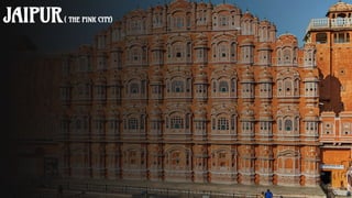
- 23. ARCHITECTURE (HAWA MAHAL) ● The main architect of this palace built of red and pink sandstone, is Lal Chand Ustad and the palace is believed to have been constructed in the form of the crown of Krishna, the Hindu god. Considered as an embodiment of Rajputana architecture, the main highlight of Hawa Mahal is its pyramid shape and its 953 windows or 'Jharokhas' which are decorated with intricate designs. ● The main intention behind the construction of the Mahal was to facilitate the royal women and provide them a view of everyday life through the windows, as they never appeared in public. ● Hawa Mahal, designed as a beehive castle with small windows, has a height of 50 feet from its base. ● This structure, erected on a thin shield or podium approximately fifty feet high, has walls less than a foot thick. ● Constructed of red and pink sandstones by Lal Chand Ustad, ● Hawa Mahal is famous for its windows or 'Jharokhas' which enable free circulation of air within the structure.
- 24. ARCHITECTURE (DIWAN-I-AM) It has forty pillars and is a best example of intricate craftsmanship. The wide assembly hall measures 201' by 67' and has flat roof with two gateways of arched red sandstone to the north and south. The hall is divided in three parts and has nine bold arches. This is built in red sandstone and is plastered with white shell plaster which looks like white marble. There is also a raised rectangular stage from where the emperor used to address the audience.
- 25. ARCHITECTURE FEATURES OF JAIPUR
- 26. ARCHITECTURE FEATURES OF JAIPUR
- 27. CULTURE