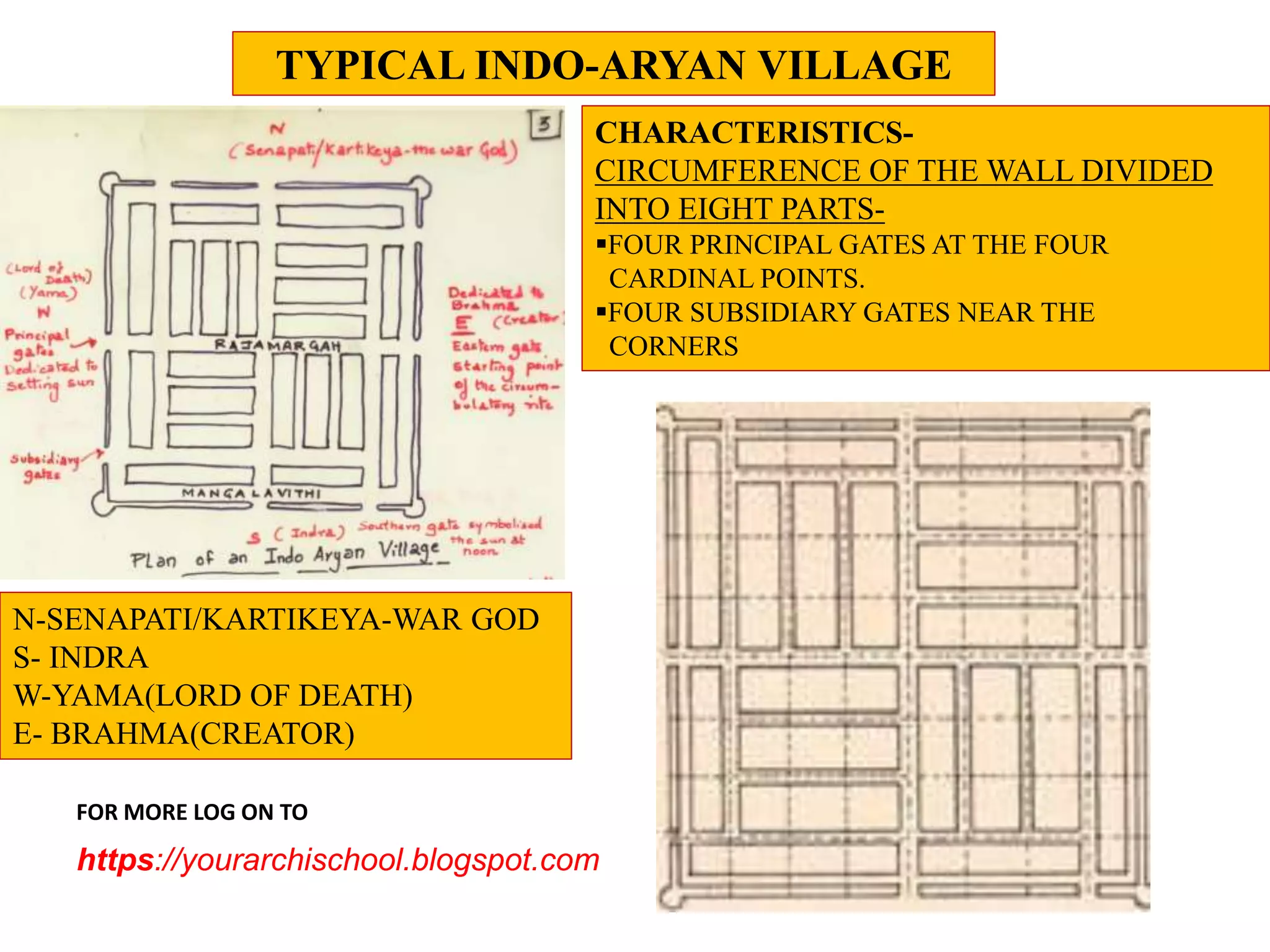
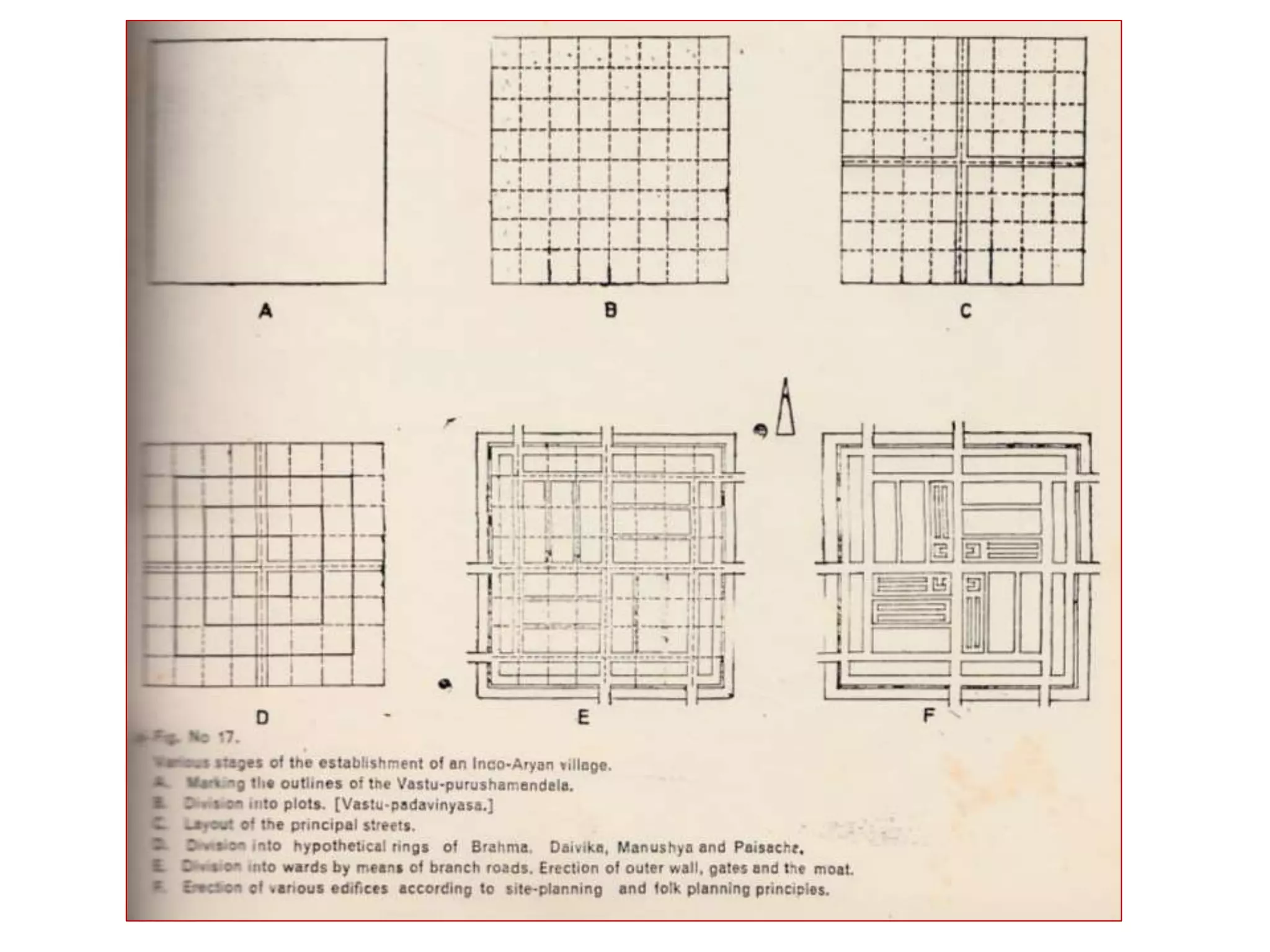
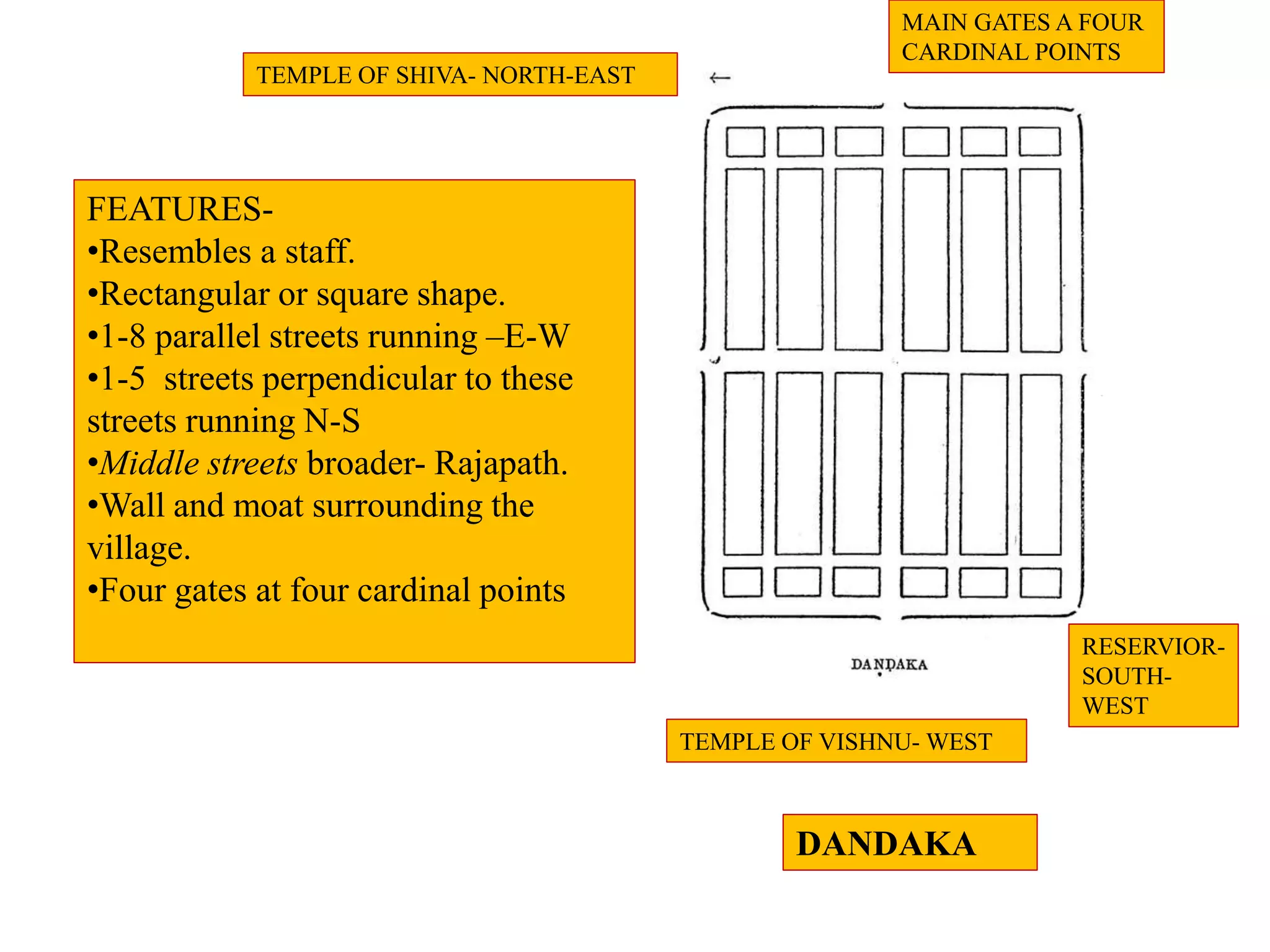
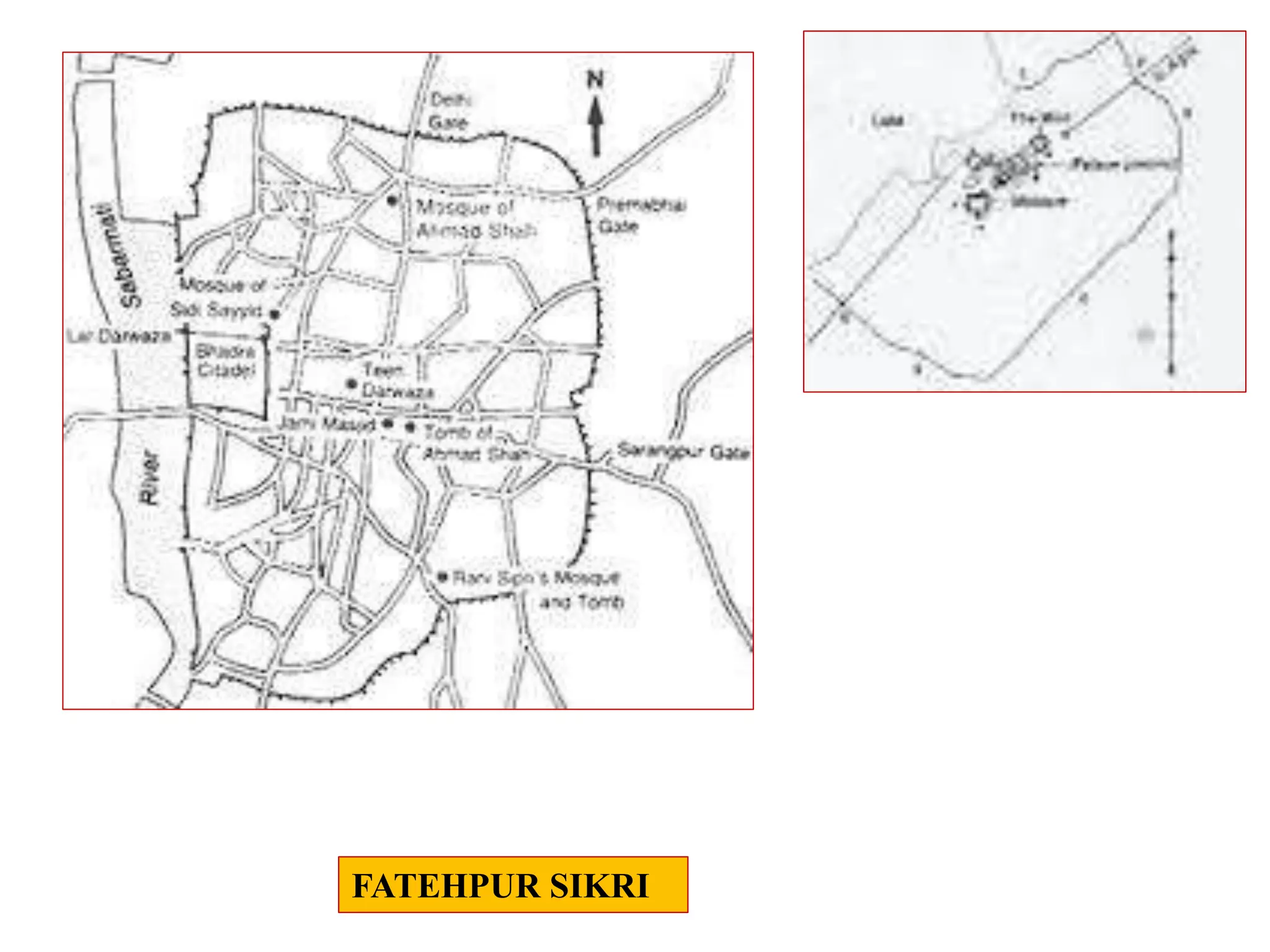
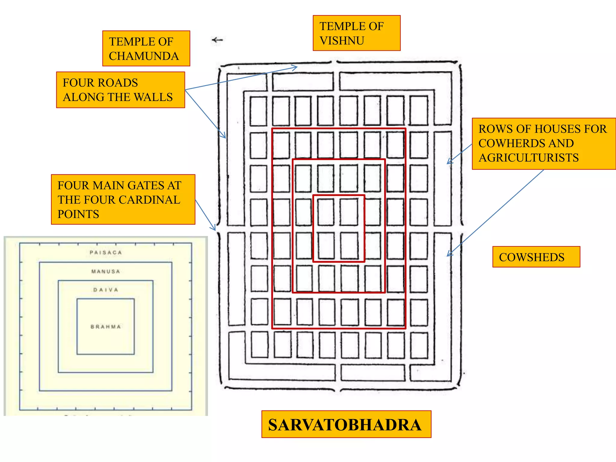
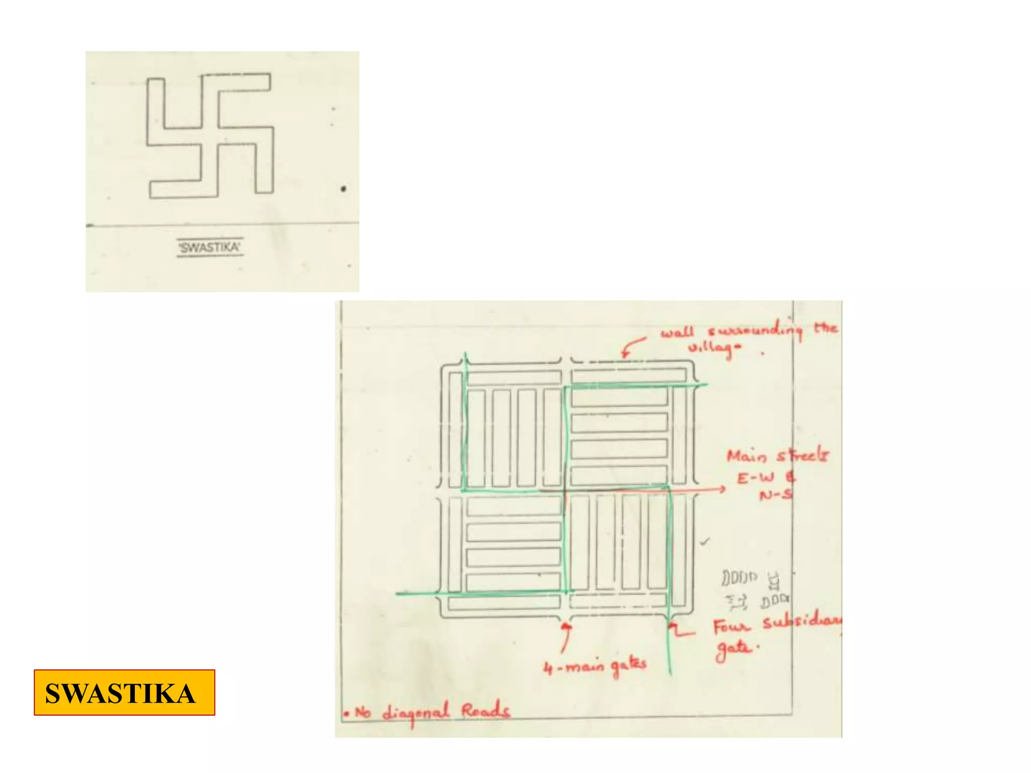
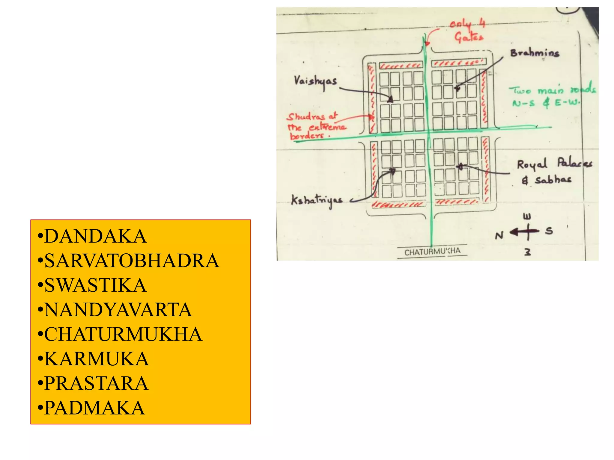
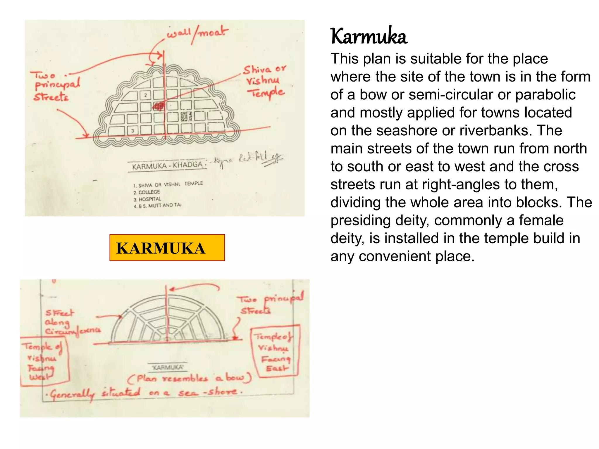
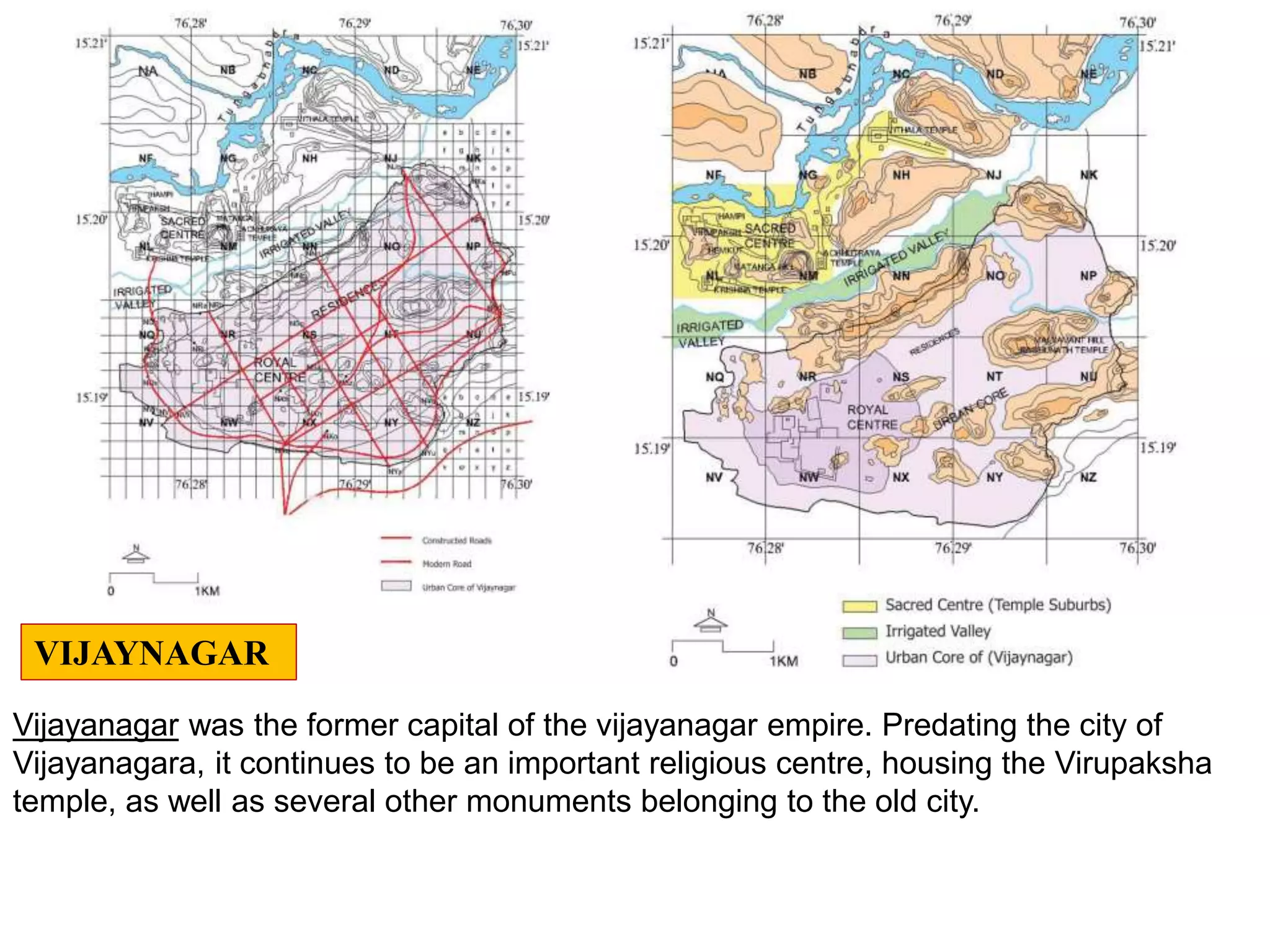
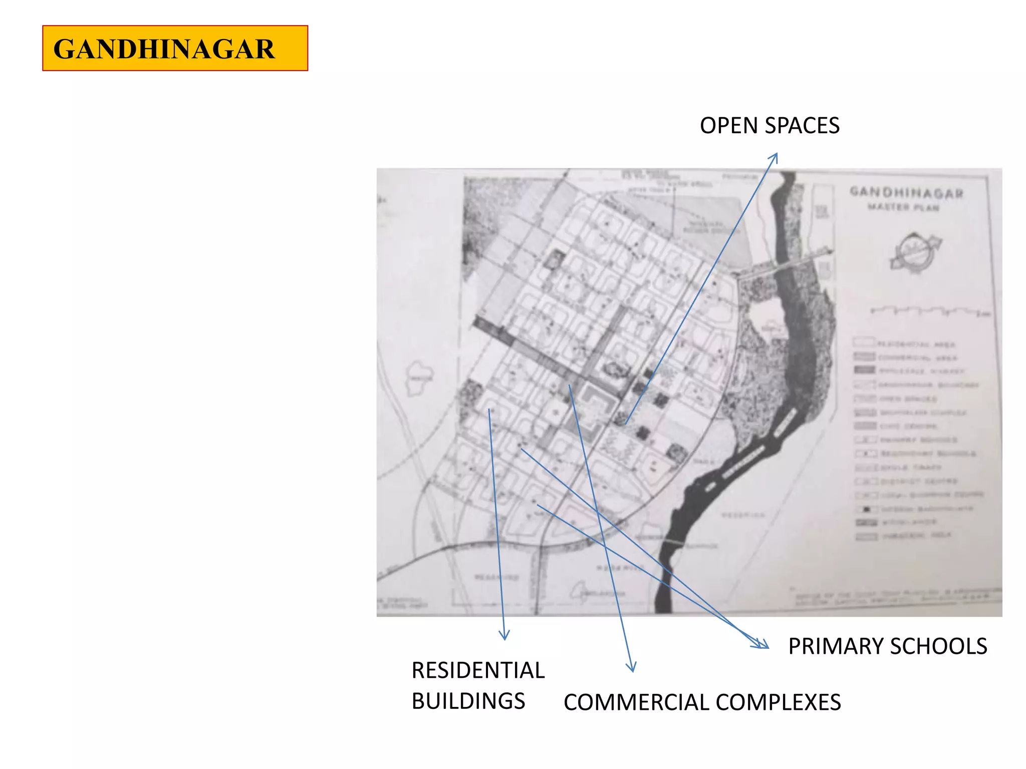
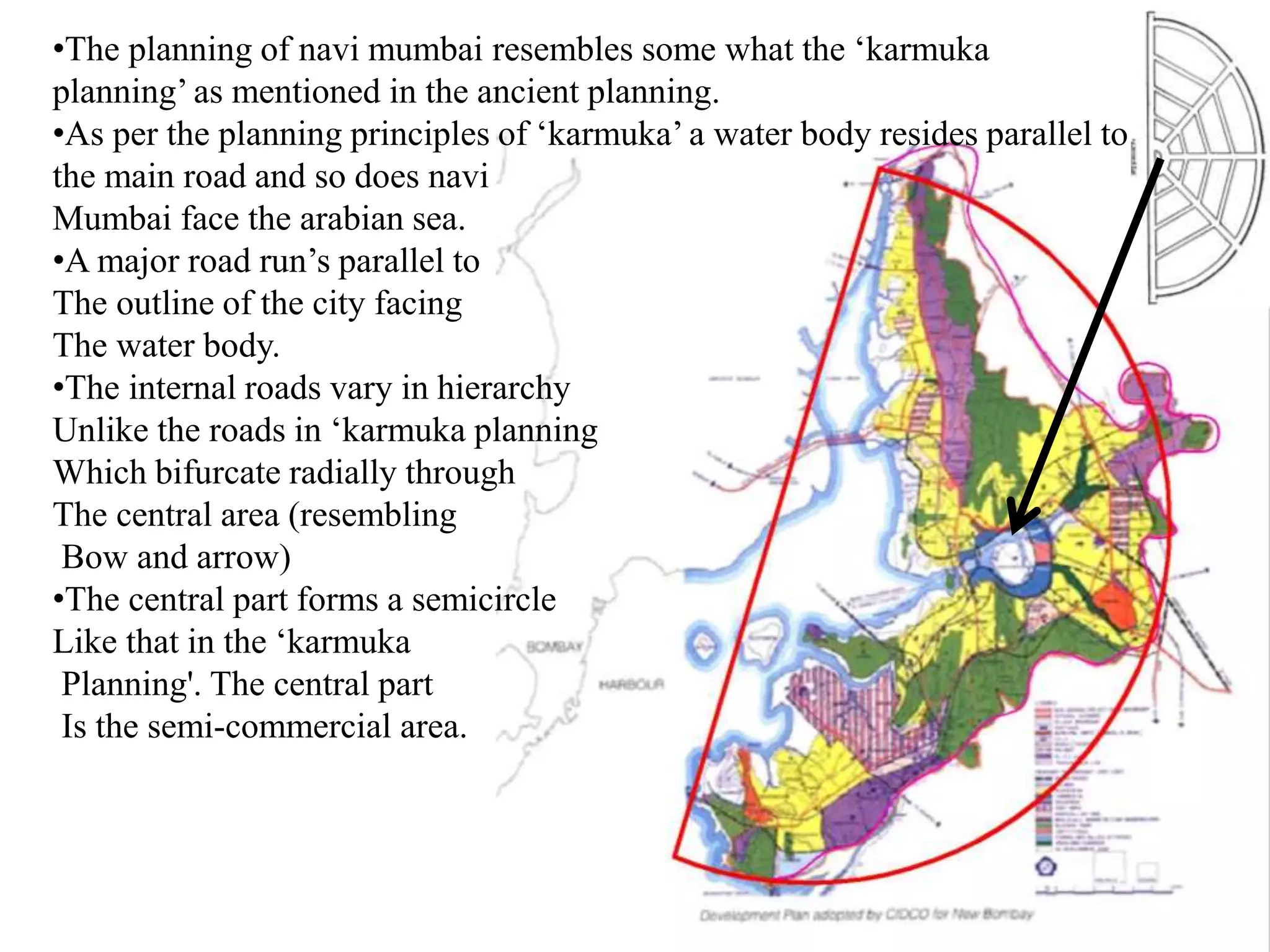
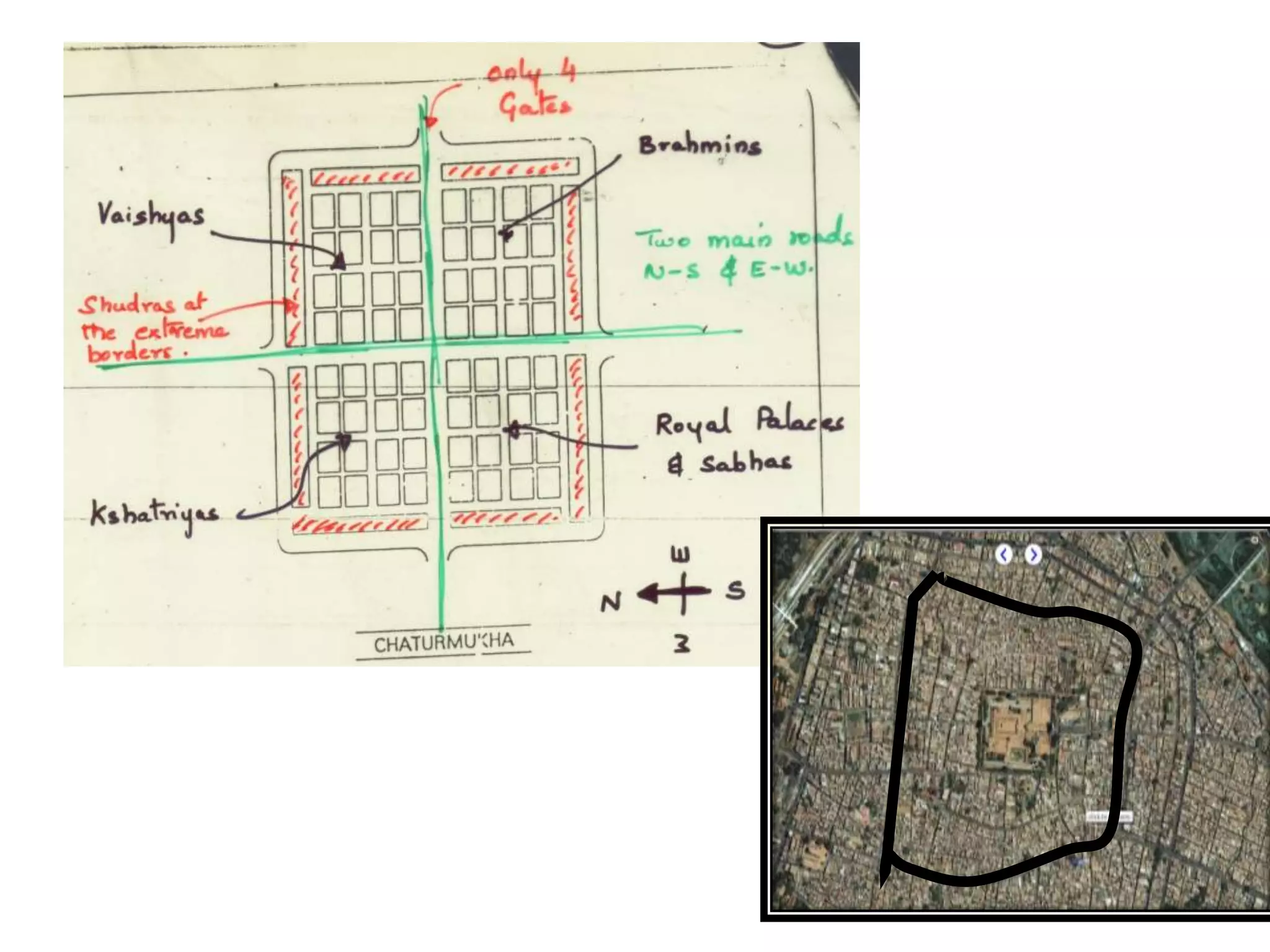
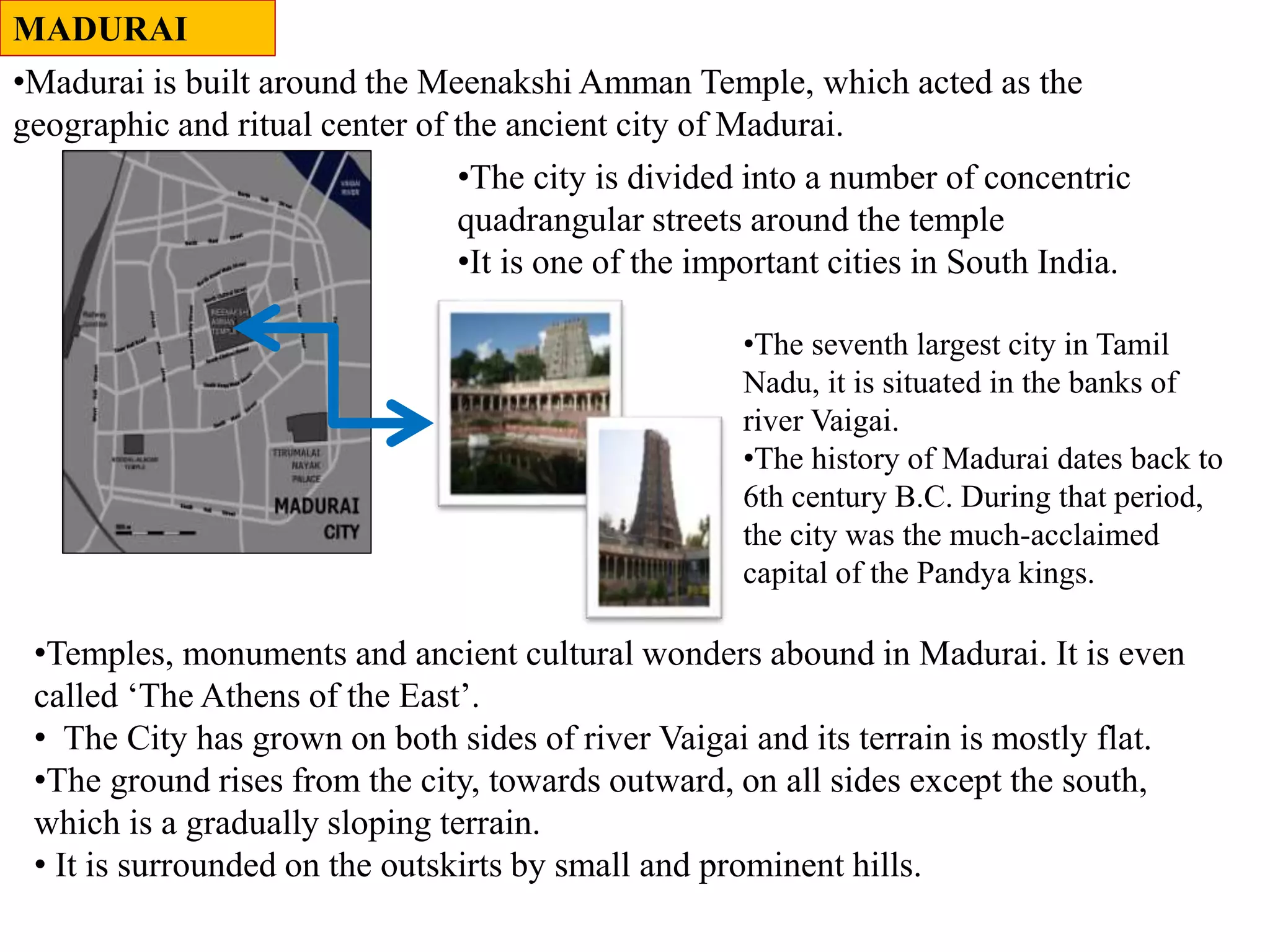
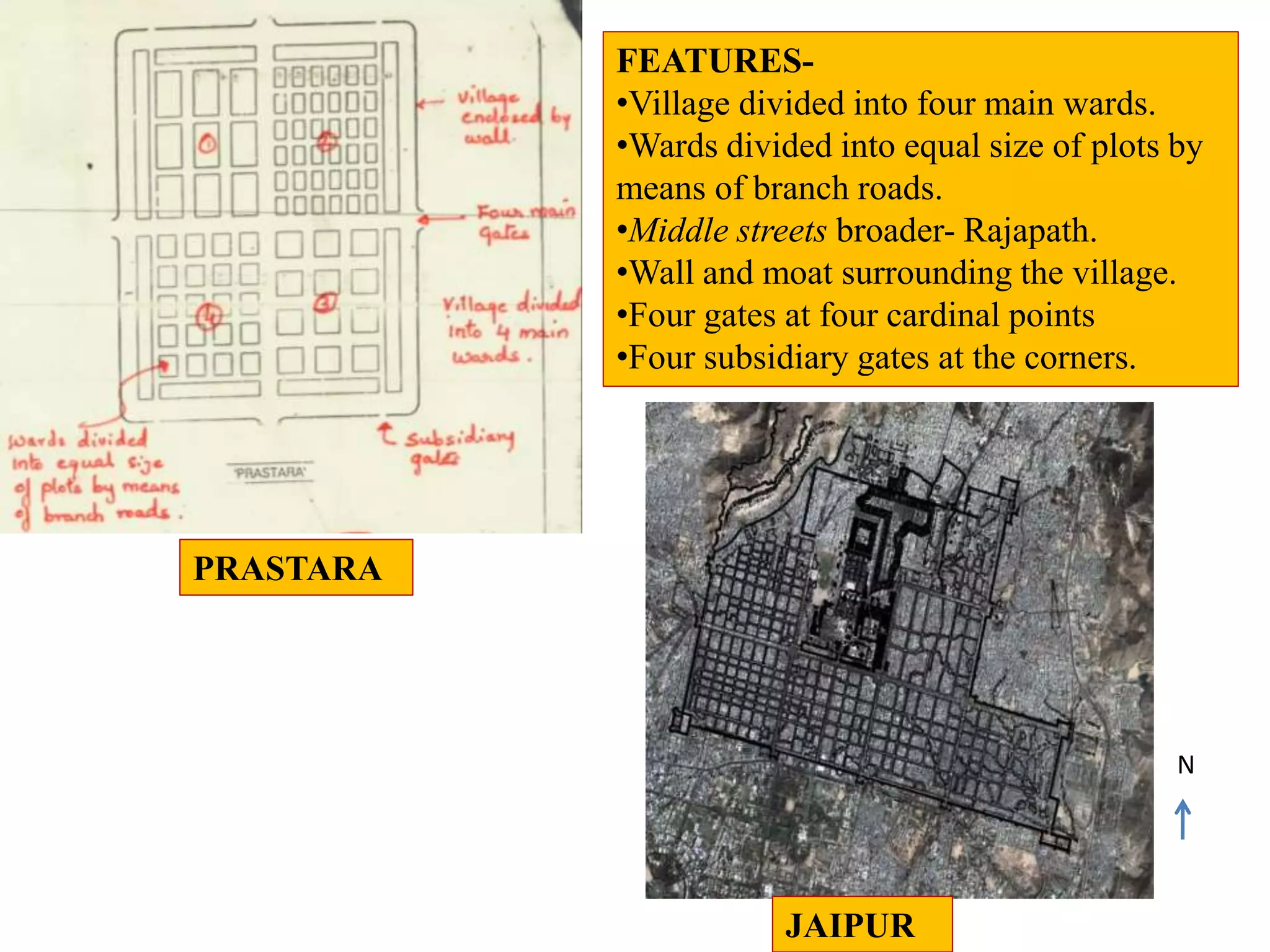
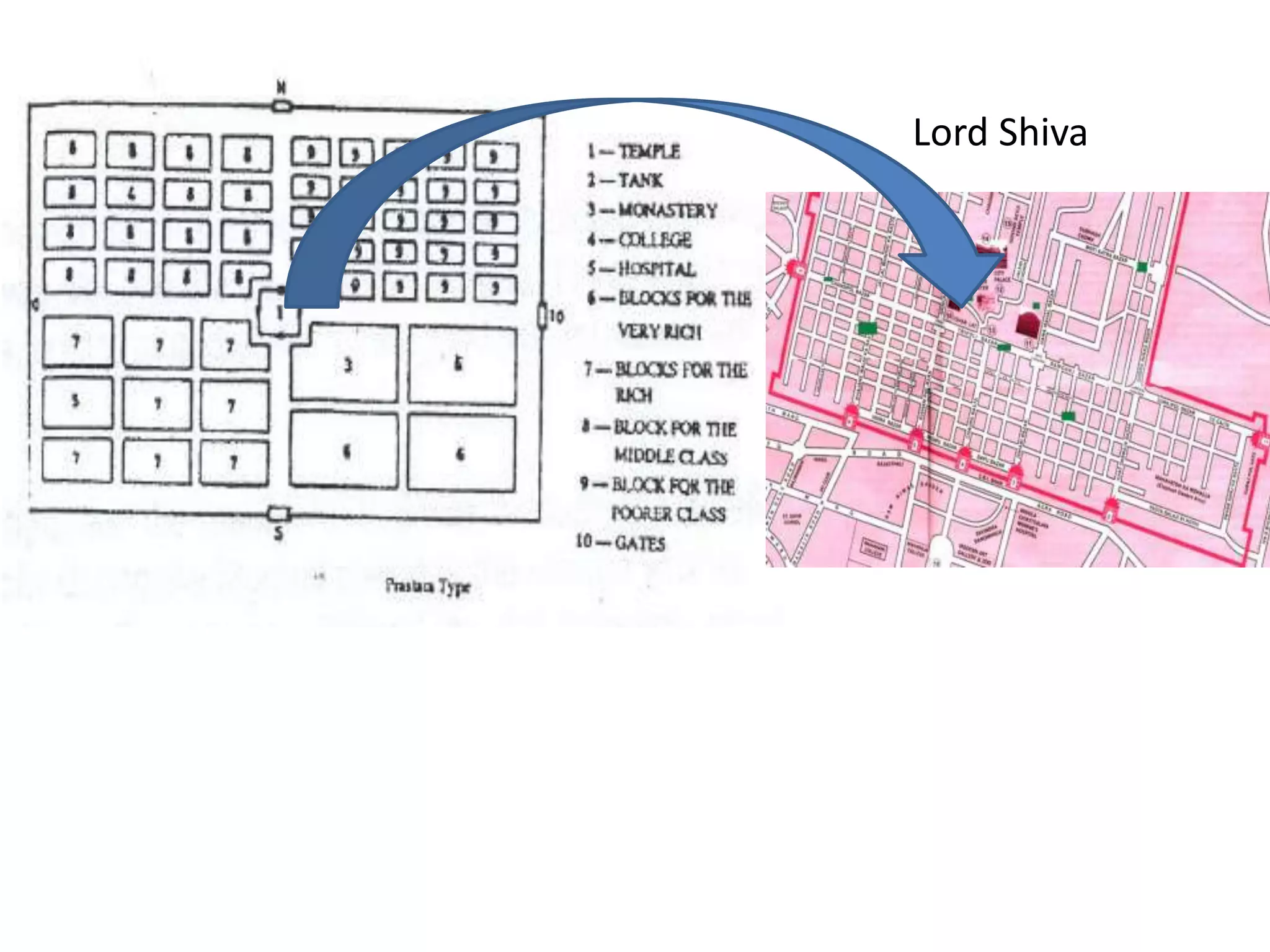
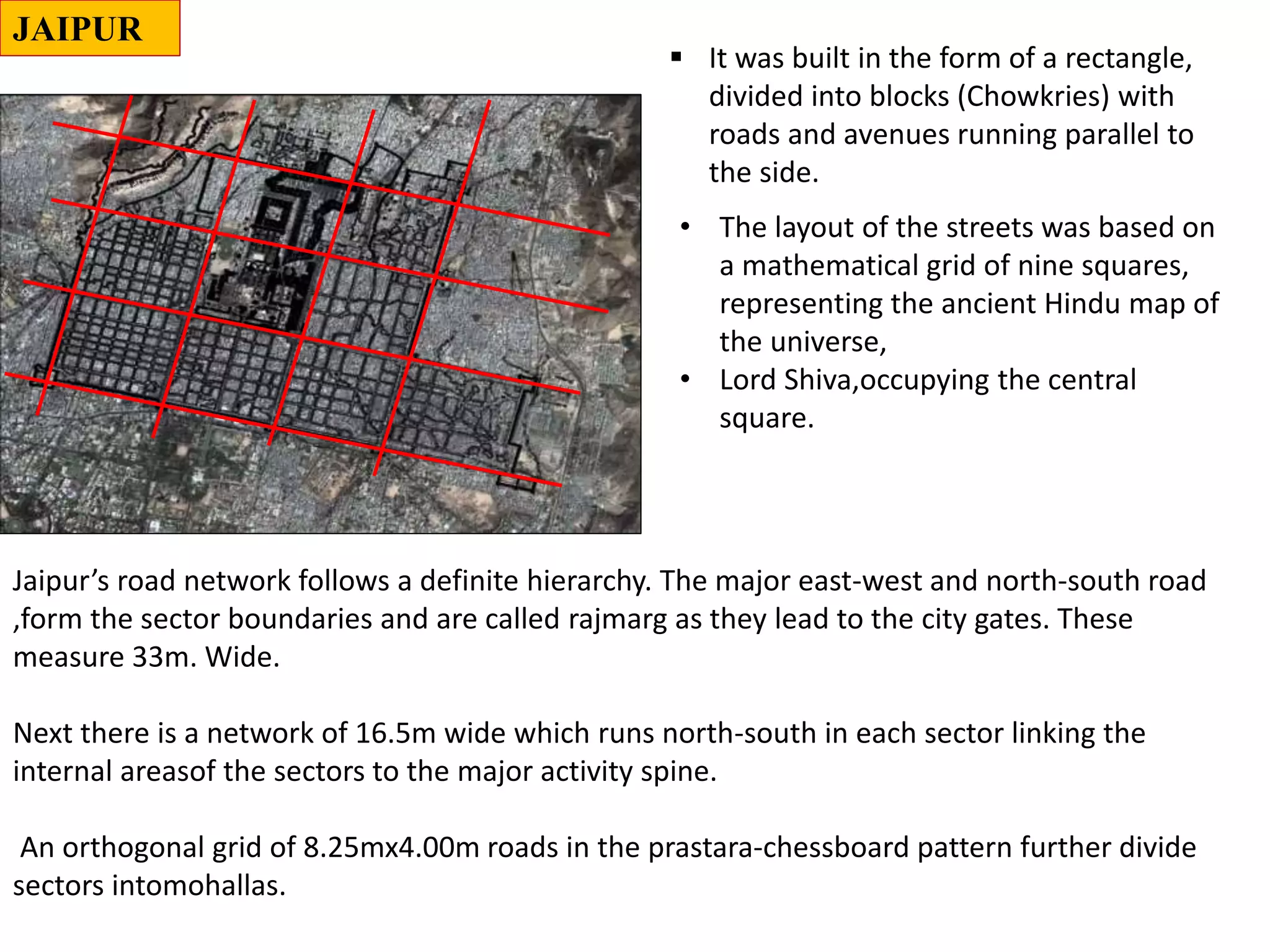
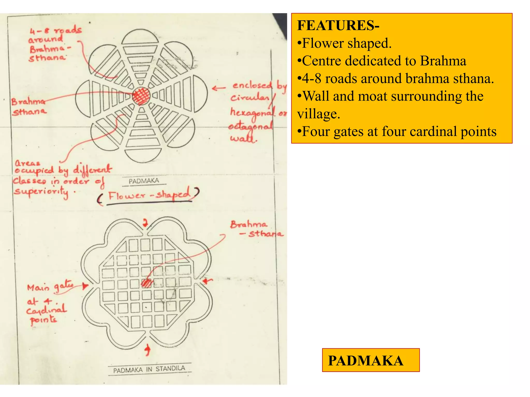
TYPICAL INDO-ARYAN VILLAGE
N-SENAPATI/KARTIKEYA-WAR GOD
S- INDRA
W-YAMA(LORD OF DEATH)
E- BRAHMA(CREATOR)
CHARACTERISTICS-
CIRCUMFERENCE OF THE WALL DIVIDED
INTO EIGHT PARTS-
FOUR PRINCIPAL GATES AT THE FOUR
CARDINAL POINTS.
FOUR SUBSIDIARY GATES NEAR THE
CORNERS
https://yourarchischool.blogspot.com
FOR MORE LOG ON TO
CLASSIFICATION AS PER MANSARA
•SHAPE
•METHOD OF STREET PLANNING
•LOCATION OF TEMPLE
CONSIDERATIONS
•DANDAKA
•SARVATOBHADRA
•SWASTIKA
•NANDYAVARTA
•CHATURMUKHA
•KARMUKA
•PRASTARA
•PADMAKA
FEATURES-
•Resembles a staff.
•Rectangular or square shape.
•1-8 parallel streets running –E-W
•1-5 streets perpendicular to these
streets running N-S
•Middle streets broader- Rajapath.
•Wall and moat surrounding the
village.
•Four gates at four cardinal points
TEMPLE OF VISHNU- WEST
TEMPLE OF SHIVA- NORTH-EAST
RESERVIOR-
SOUTH-
WEST
DANDAKA
MAIN GATES A FOUR
CARDINAL POINTS
FATEHPUR SIKRI
ROWS OF HOUSES FOR
COWHERDS AND
AGRICULTURISTS
COWSHEDS
SARVATOBHADRA
FOUR ROADS
ALONG THE WALLS
TEMPLE OF
VISHNUTEMPLE OF
CHAMUNDA
FOUR MAIN GATES AT
THE FOUR CARDINAL
POINTS
The design of the city is based on a grid-iron plan based on the hierarchy of movement
from highways to pedestrian walkways.
•Le Corbusier conceived the master plan of Chandigarh as analogous to human body:
• Head (the Capitol Complex, Sector 1),
• Heart (the City Centre Sector-17),
• Lungs ( the leisure valley, innumerable open spaces and sector greens),
• the intellect (the cultural and educational institutions),
• The circulatory system (the network of roads, the 7Vs) and the viscera (the Industrial
Area).
• The concept of the city is based on four major functions: living, working, care of the
body and spirit and circulation.
The roads of the city are classified into
the system of 7 Vs.
(i) V-1, fast roads connecting Chandigarh
to other towns;
(ii) V-2, arterial roads;
(iii) V-3, fast vehicular roads;
(iv) V-4, meandering shopping streets;
(v) V-5, sector circulation roads;
(vi) V-6, access roads to houses; and
(vii) V-7, footpaths and cycle tracks.
CHANDIGARH
SWASTIKA
NANDYAVARTA- ABODE OF HAPPINESS
•DANDAKA
•SARVATOBHADRA
•SWASTIKA
•NANDYAVARTA
•CHATURMUKHA
•KARMUKA
•PRASTARA
•PADMAKA
Karmuka
This plan is suitable for the place
where the site of the town is in the form
of a bow or semi-circular or parabolic
and mostly applied for towns located
on the seashore or riverbanks. The
main streets of the town run from north
to south or east to west and the cross
streets run at right-angles to them,
dividing the whole area into blocks. The
presiding deity, commonly a female
deity, is installed in the temple build in
any convenient place.
KARMUKA
Vijayanagar was the former capital of the vijayanagar empire. Predating the city of
Vijayanagara, it continues to be an important religious centre, housing the Virupaksha
temple, as well as several other monuments belonging to the old city.
VIJAYNAGAR
COMMERCIAL COMPLEXES
RESIDENTIAL
BUILDINGS
OPEN SPACES
PRIMARY SCHOOLS
GANDHINAGAR
•The planning of navi mumbai resembles some what the ‘karmuka
planning’ as mentioned in the ancient planning.
•As per the planning principles of ‘karmuka’ a water body resides parallel to
the main road and so does navi
Mumbai face the arabian sea.
•A major road run’s parallel to
The outline of the city facing
The water body.
•The internal roads vary in hierarchy
Unlike the roads in ‘karmuka planning
Which bifurcate radially through
The central area (resembling
Bow and arrow)
•The central part forms a semicircle
Like that in the ‘karmuka
Planning'. The central part
Is the semi-commercial area.
MADURAI
•The city is divided into a number of concentric
quadrangular streets around the temple
•It is one of the important cities in South India.
•Madurai is built around the Meenakshi Amman Temple, which acted as the
geographic and ritual center of the ancient city of Madurai.
•Temples, monuments and ancient cultural wonders abound in Madurai. It is even
called ‘The Athens of the East’.
• The City has grown on both sides of river Vaigai and its terrain is mostly flat.
•The ground rises from the city, towards outward, on all sides except the south,
which is a gradually sloping terrain.
• It is surrounded on the outskirts by small and prominent hills.
•The seventh largest city in Tamil
Nadu, it is situated in the banks of
river Vaigai.
•The history of Madurai dates back to
6th century B.C. During that period,
the city was the much-acclaimed
capital of the Pandya kings.
PRASTARA
FEATURES-
•Village divided into four main wards.
•Wards divided into equal size of plots by
means of branch roads.
•Middle streets broader- Rajapath.
•Wall and moat surrounding the village.
•Four gates at four cardinal points
•Four subsidiary gates at the corners.
JAIPUR
N
Lord Shiva
 It was built in the form of a rectangle,
divided into blocks (Chowkries) with
roads and avenues running parallel to
the side.
JAIPUR
• The layout of the streets was based on
a mathematical grid of nine squares,
representing the ancient Hindu map of
the universe,
• Lord Shiva,occupying the central
square.
Jaipur’s road network follows a definite hierarchy. The major east-west and north-south road
,form the sector boundaries and are called rajmarg as they lead to the city gates. These
measure 33m. Wide.
Next there is a network of 16.5m wide which runs north-south in each sector linking the
internal areasof the sectors to the major activity spine.
An orthogonal grid of 8.25mx4.00m roads in the prastara-chessboard pattern further divide
sectors intomohallas.
PADMAKA
FEATURES-
•Flower shaped.
•Centre dedicated to Brahma
•4-8 roads around brahma sthana.
•Wall and moat surrounding the
village.
•Four gates at four cardinal points

Ancient town classifications

  • 1.
    TYPICAL INDO-ARYAN VILLAGE N-SENAPATI/KARTIKEYA-WARGOD S- INDRA W-YAMA(LORD OF DEATH) E- BRAHMA(CREATOR) CHARACTERISTICS- CIRCUMFERENCE OF THE WALL DIVIDED INTO EIGHT PARTS- FOUR PRINCIPAL GATES AT THE FOUR CARDINAL POINTS. FOUR SUBSIDIARY GATES NEAR THE CORNERS https://yourarchischool.blogspot.com FOR MORE LOG ON TO
  • 3.
    CLASSIFICATION AS PERMANSARA •SHAPE •METHOD OF STREET PLANNING •LOCATION OF TEMPLE CONSIDERATIONS •DANDAKA •SARVATOBHADRA •SWASTIKA •NANDYAVARTA •CHATURMUKHA •KARMUKA •PRASTARA •PADMAKA
  • 4.
    FEATURES- •Resembles a staff. •Rectangularor square shape. •1-8 parallel streets running –E-W •1-5 streets perpendicular to these streets running N-S •Middle streets broader- Rajapath. •Wall and moat surrounding the village. •Four gates at four cardinal points TEMPLE OF VISHNU- WEST TEMPLE OF SHIVA- NORTH-EAST RESERVIOR- SOUTH- WEST DANDAKA MAIN GATES A FOUR CARDINAL POINTS
  • 5.
  • 6.
    ROWS OF HOUSESFOR COWHERDS AND AGRICULTURISTS COWSHEDS SARVATOBHADRA FOUR ROADS ALONG THE WALLS TEMPLE OF VISHNUTEMPLE OF CHAMUNDA FOUR MAIN GATES AT THE FOUR CARDINAL POINTS
  • 8.
    The design ofthe city is based on a grid-iron plan based on the hierarchy of movement from highways to pedestrian walkways. •Le Corbusier conceived the master plan of Chandigarh as analogous to human body: • Head (the Capitol Complex, Sector 1), • Heart (the City Centre Sector-17), • Lungs ( the leisure valley, innumerable open spaces and sector greens), • the intellect (the cultural and educational institutions), • The circulatory system (the network of roads, the 7Vs) and the viscera (the Industrial Area). • The concept of the city is based on four major functions: living, working, care of the body and spirit and circulation. The roads of the city are classified into the system of 7 Vs. (i) V-1, fast roads connecting Chandigarh to other towns; (ii) V-2, arterial roads; (iii) V-3, fast vehicular roads; (iv) V-4, meandering shopping streets; (v) V-5, sector circulation roads; (vi) V-6, access roads to houses; and (vii) V-7, footpaths and cycle tracks. CHANDIGARH
  • 9.
  • 10.
  • 11.
  • 12.
    Karmuka This plan issuitable for the place where the site of the town is in the form of a bow or semi-circular or parabolic and mostly applied for towns located on the seashore or riverbanks. The main streets of the town run from north to south or east to west and the cross streets run at right-angles to them, dividing the whole area into blocks. The presiding deity, commonly a female deity, is installed in the temple build in any convenient place. KARMUKA
  • 14.
    Vijayanagar was theformer capital of the vijayanagar empire. Predating the city of Vijayanagara, it continues to be an important religious centre, housing the Virupaksha temple, as well as several other monuments belonging to the old city. VIJAYNAGAR
  • 15.
  • 16.
    •The planning ofnavi mumbai resembles some what the ‘karmuka planning’ as mentioned in the ancient planning. •As per the planning principles of ‘karmuka’ a water body resides parallel to the main road and so does navi Mumbai face the arabian sea. •A major road run’s parallel to The outline of the city facing The water body. •The internal roads vary in hierarchy Unlike the roads in ‘karmuka planning Which bifurcate radially through The central area (resembling Bow and arrow) •The central part forms a semicircle Like that in the ‘karmuka Planning'. The central part Is the semi-commercial area.
  • 18.
    MADURAI •The city isdivided into a number of concentric quadrangular streets around the temple •It is one of the important cities in South India. •Madurai is built around the Meenakshi Amman Temple, which acted as the geographic and ritual center of the ancient city of Madurai. •Temples, monuments and ancient cultural wonders abound in Madurai. It is even called ‘The Athens of the East’. • The City has grown on both sides of river Vaigai and its terrain is mostly flat. •The ground rises from the city, towards outward, on all sides except the south, which is a gradually sloping terrain. • It is surrounded on the outskirts by small and prominent hills. •The seventh largest city in Tamil Nadu, it is situated in the banks of river Vaigai. •The history of Madurai dates back to 6th century B.C. During that period, the city was the much-acclaimed capital of the Pandya kings.
  • 19.
    PRASTARA FEATURES- •Village divided intofour main wards. •Wards divided into equal size of plots by means of branch roads. •Middle streets broader- Rajapath. •Wall and moat surrounding the village. •Four gates at four cardinal points •Four subsidiary gates at the corners. JAIPUR N
  • 20.
  • 21.
     It wasbuilt in the form of a rectangle, divided into blocks (Chowkries) with roads and avenues running parallel to the side. JAIPUR • The layout of the streets was based on a mathematical grid of nine squares, representing the ancient Hindu map of the universe, • Lord Shiva,occupying the central square. Jaipur’s road network follows a definite hierarchy. The major east-west and north-south road ,form the sector boundaries and are called rajmarg as they lead to the city gates. These measure 33m. Wide. Next there is a network of 16.5m wide which runs north-south in each sector linking the internal areasof the sectors to the major activity spine. An orthogonal grid of 8.25mx4.00m roads in the prastara-chessboard pattern further divide sectors intomohallas.
  • 22.
    PADMAKA FEATURES- •Flower shaped. •Centre dedicatedto Brahma •4-8 roads around brahma sthana. •Wall and moat surrounding the village. •Four gates at four cardinal points