IRJET- Pollution Assessment of Water Bodies in Muvattupuzha Muncipality After Flood (2018) using GIS
•
0 likes•52 views

https://www.irjet.in/archives/V6/i5/IRJET-V6I5646.pdf
![International Research Journal of Engineering and Technology (IRJET) e-ISSN: 2395-0056
Volume: 06 Issue: 05 | May 2019 www.irjet.net p-ISSN: 2395-0072
© 2019, IRJET | Impact Factor value: 7.211 | ISO 9001:2008 Certified Journal | Page 5129
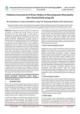
km 2 . Ten different sampling points were selected in the
study area. The locations were chosen keeping in mind that
all the areas of Muvattupuzha can be covered properly.
Fig -1.Study Area
Sampling locations
30 samples were collected from water bodies fromlocations
in Muvattupuzha muncipality. The latitude and longitude of
the area was also determined using google maps.
Table 1.GPS co-ordinates of Sampling Locations
No Station name Latitude Longitude
1 Kakkadashery 9.9972527 76.5989237
2 Kakkadashery 9.9972201 76.5987561
3 Kakkadashery 9.9972032 76.5985375
4 Perumattam 9.996524 76.5956863
5 Perumattam 9.9965798 76.5955109
6 Perumattam 9.9967984 76.5952846
7 Perumattam 9.992539 76.5986323
8 Perumattam 9.9925271 76.5987215
9 Perumattam 9.9924175 76.5969519
10 Kizhakekara 9.9925116 76.5969244
11 Kizhakekara 9.9839589 76.5887393
12 Kizhakekara 9.9838585 76.5887189
13 Kizhakekara 9.9836921 76.5888486
14 Chalikadav 9.9840847 76.5888436
15 Kaliyar river basin 9.9853639 76.5883498
16 Thodupuzha river
Basin
9.9926839 76.590969
17 Latha theatre 9.9712925 76.59358
18 Chalikadav 9.9796755 76.5828844
19 Market 9.9908038 76.5903752
20 Triveni sangamam 9.9883228 76.5863113
21 Nedumchalil 9.9855121 76.583381
22 Market 9.9885262 76.577878
23 Market 9.9913021 76.5882093
24 Market 9.9915042 76.5881281
25 Muvattupuzha
river basin
9.9911031 76.5878978
26 Arakuzha 9.9857816 76.5805539
27 Kecherippady 9.9756707 76.5871132
28 Kecherippady 9.9936725 76.5825357
29 Kecherippady 9.9924505 76.5795766
30 Kecherippady 9.9945115 76.5831121
3. WATER QUALITY INDEX
The water samples were analyzed for different physio-
chemical parameters and were compared with the values of
various quality standards such as world health organization
(who), bureau of Indian standards (bis) and indian council
for medical research. Turbidity, DO, hardness , pH, alkalinity
and chloride are the various water quality parameters
analysed. Water Quality Index (WQI) was calculated by
using the Weighted Arithmetic Index method. In this model,
different water quality components are multiplied by a
weighting factor and are then aggregated using simple
arithmetic mean. The overall WQi was calculated by
aggregating the quality rating with the unit weight linearly
by using the following equation.
WQI = ∑WnQn / ∑Wn
Qn = quality rating, Wn= relative weight
Qn=100[(vn-vio)/ (sn-vio)]
qn=quality rating for the nth water quality
parameter,vn=observed value of the nth parameter
sn=standard permissible value of nth parameter vio=ideal
value of nth parameter in pure water. Alltheidealvalues(vio)
are taken as zero for drinking water except for ph=7 and
dissolved oxygen=14.6mg/l.
Wn=k/sn
Where , Wn= unit weight of nth parameter sn=standard value
for the nth parameter. K=constant of proportionality and is
given as (kalavathy et al.,2011) k=1/[1/vs1+1/vs2+…+1/vsn].
Table 2.Water Quality Status
Class WQI Water Quality Status
I <50 Excellent
II 50-100 Good
III 100-200
Poor
IV
200-300 Very Poor
V >300 Unsuitable For Drinking](data:image/gif;base64,R0lGODlhAQABAIAAAAAAAP///yH5BAEAAAAALAAAAAABAAEAAAIBRAA7)
Recommended
Recommended
More Related Content
What's hot
What's hot (19)
Similar to IRJET- Pollution Assessment of Water Bodies in Muvattupuzha Muncipality After Flood (2018) using GIS
Similar to IRJET- Pollution Assessment of Water Bodies in Muvattupuzha Muncipality After Flood (2018) using GIS (20)
More from IRJET Journal
More from IRJET Journal (20)
Recently uploaded
Recently uploaded (20)
IRJET- Pollution Assessment of Water Bodies in Muvattupuzha Muncipality After Flood (2018) using GIS
- 1. International Research Journal of Engineering and Technology (IRJET) e-ISSN: 2395-0056 Volume: 06 Issue: 05 | May 2019 www.irjet.net p-ISSN: 2395-0072 © 2019, IRJET | Impact Factor value: 7.211 | ISO 9001:2008 Certified Journal | Page 5128 Pollution Assessment of Water Bodies in Muvattupuzha Muncipality after Flood (2018) using GIS Mr. Rasim Navas1, Fasina Fackrudheen2, Haja T.B2, Mohammed Shafeer P.M2, Nehas Nazar2 1Assistant Professor, Dept. of Civil Engineering, Ilahia College of Engineering and Technology, Kerala, India 2B-Tech Student, Dept. of Civil Engineering, Ilahia College of Engineering and Technology, Kerala, India ---------------------------------------------------------------------***---------------------------------------------------------------------- Abstract - Management of water quality is very important as demand is increases day by day. Water is the most important source for living things on earth which is threatened on its quality and quantity. Ph, DO, COD, E coli, Turbidity, Alkalinity, Chloride and Hardness are basic water quality parameters. Management of water quality in Muvattupuzha municipality after flood (2018)isimportantas it is the source of drinking, domestic uses and irrigation. Deterioration of water quality receives more attention to mapping the current situation of water quality parameter provides the better management of resources. Water samples collected from various resources located in Muvattupuzha during dry period, whereas when entire town under great water stress. Interpolation methods facilitate to estimate values for unknown point and create a continuous dataset to study the spatial distribution. The IDW and Spline tools are deterministic interpolation methodandKrigingarebasedona statistical model. Kriging is thebestfitmethodofinterpolation was used with the help of Geographic Information System (GIS) software Arc GIS 10.4 to visualizethespatialdistribution of above water quality parameters. This study has shown that Kriging interpolation and statistical analysis perform better mapping of water parameter. Thewaterqualityindex(WQI) is a single number that expresses the quality of water by integrating the water quality variables. This Paper also deals with the assessment of ground water quality in and around Muvattupuzha Municipality, Kerala State Of India. Key Words: water quality index, geographic positioning system, geographic information system, physio - chemical parameters, kriging interpolation, Weighted Aritmetic Index Method 1. INTRODUCTION Water is the most precious gift of nature, the most crucial for sustaining life and is required in almost all the activities of man for drinking and municipal use, irrigation to meet the needs of growing food, industries, power generation, navigation, and recreation. Hencetheconservation,optimum utilization and managementofresourcesforthebettermethe economic status of the country become paramount. Water quality index provides a single number that expresses overall water quality at a certain location and time, based on several water quality parameters. The objective of water quality index is to turn complex water quality data into information that is understandable and usable for common man. A single number is not enough to describe the water quality: there are many other water quality parameters that are not included in the index.However, a water quality index based on some very important parameters can provide a simple indicator of water quality. In general, water quality indices incorporate data from multiple water quality parameters into a mathematical equation that rates the health of a water body with number. The main aim of our project is to prepare the water quality map ofwaterbodiesin Muvattupuzha municipality. 1.1Water Quality Mapping Using GIS Mapping the water quality parameters using the decision support system like GIS, can be useful for taking quick decisions as graphical representation would be easy to facilitate policy makers in taking a decision. A Spatial Decision Support System (SDSS) is a computer based system designed to assist the decision system. Typically, such a system will include spatial data relevant to the decision, analytical tools to process the data in ways meaningful for decision makers, and output ordisplayfunctions.Geographic Information System (GIS) is an information system that is specially designedforhandlingspatial(orgeographical)data. GIS has the advantage of handling attribute data in conjunction with spatial features, which was totally impossible with manual cartographic analysis. It combines a set of interrelated software components that create, edit, manipulate, analyse anddisplaydatabothintextandgraphic forms. 1.2 Water Quality Analysis Water quality index provides a singlenumberthatexpresses overall water quality at a certain location and time, basedon several water quality parameters. The objective of water quality index is to turn complex water quality data into information that is understandable and usable for common man. A single number is not enough to describe the water quality: there are many other water quality parameters that are not included in the index. However, a water quality index based on some veryimportantparameterscanprovide a simple indicator of water quality. 2. STUDY AREA For the present study, Muvattupuzha municipality of Ernakulum district was selected. It is located at a latitude of 9° 58′ 47.46″ n, and longitude of 76° 34′ 25.72″ e and is in the foothills of the western ghats and covers anarea of13.18
- 2. International Research Journal of Engineering and Technology (IRJET) e-ISSN: 2395-0056 Volume: 06 Issue: 05 | May 2019 www.irjet.net p-ISSN: 2395-0072 © 2019, IRJET | Impact Factor value: 7.211 | ISO 9001:2008 Certified Journal | Page 5129 km 2 . Ten different sampling points were selected in the study area. The locations were chosen keeping in mind that all the areas of Muvattupuzha can be covered properly. Fig -1.Study Area Sampling locations 30 samples were collected from water bodies fromlocations in Muvattupuzha muncipality. The latitude and longitude of the area was also determined using google maps. Table 1.GPS co-ordinates of Sampling Locations No Station name Latitude Longitude 1 Kakkadashery 9.9972527 76.5989237 2 Kakkadashery 9.9972201 76.5987561 3 Kakkadashery 9.9972032 76.5985375 4 Perumattam 9.996524 76.5956863 5 Perumattam 9.9965798 76.5955109 6 Perumattam 9.9967984 76.5952846 7 Perumattam 9.992539 76.5986323 8 Perumattam 9.9925271 76.5987215 9 Perumattam 9.9924175 76.5969519 10 Kizhakekara 9.9925116 76.5969244 11 Kizhakekara 9.9839589 76.5887393 12 Kizhakekara 9.9838585 76.5887189 13 Kizhakekara 9.9836921 76.5888486 14 Chalikadav 9.9840847 76.5888436 15 Kaliyar river basin 9.9853639 76.5883498 16 Thodupuzha river Basin 9.9926839 76.590969 17 Latha theatre 9.9712925 76.59358 18 Chalikadav 9.9796755 76.5828844 19 Market 9.9908038 76.5903752 20 Triveni sangamam 9.9883228 76.5863113 21 Nedumchalil 9.9855121 76.583381 22 Market 9.9885262 76.577878 23 Market 9.9913021 76.5882093 24 Market 9.9915042 76.5881281 25 Muvattupuzha river basin 9.9911031 76.5878978 26 Arakuzha 9.9857816 76.5805539 27 Kecherippady 9.9756707 76.5871132 28 Kecherippady 9.9936725 76.5825357 29 Kecherippady 9.9924505 76.5795766 30 Kecherippady 9.9945115 76.5831121 3. WATER QUALITY INDEX The water samples were analyzed for different physio- chemical parameters and were compared with the values of various quality standards such as world health organization (who), bureau of Indian standards (bis) and indian council for medical research. Turbidity, DO, hardness , pH, alkalinity and chloride are the various water quality parameters analysed. Water Quality Index (WQI) was calculated by using the Weighted Arithmetic Index method. In this model, different water quality components are multiplied by a weighting factor and are then aggregated using simple arithmetic mean. The overall WQi was calculated by aggregating the quality rating with the unit weight linearly by using the following equation. WQI = ∑WnQn / ∑Wn Qn = quality rating, Wn= relative weight Qn=100[(vn-vio)/ (sn-vio)] qn=quality rating for the nth water quality parameter,vn=observed value of the nth parameter sn=standard permissible value of nth parameter vio=ideal value of nth parameter in pure water. Alltheidealvalues(vio) are taken as zero for drinking water except for ph=7 and dissolved oxygen=14.6mg/l. Wn=k/sn Where , Wn= unit weight of nth parameter sn=standard value for the nth parameter. K=constant of proportionality and is given as (kalavathy et al.,2011) k=1/[1/vs1+1/vs2+…+1/vsn]. Table 2.Water Quality Status Class WQI Water Quality Status I <50 Excellent II 50-100 Good III 100-200 Poor IV 200-300 Very Poor V >300 Unsuitable For Drinking
- 3. International Research Journal of Engineering and Technology (IRJET) e-ISSN: 2395-0056 Volume: 06 Issue: 05 | May 2019 www.irjet.net p-ISSN: 2395-0072 © 2019, IRJET | Impact Factor value: 7.211 | ISO 9001:2008 Certified Journal | Page 5130 4. GIS ANALYSIS GPS technology prove to be very useful for enhancing the spatial accuracy of the data integrated in the GIS. We utilized ArcGIS software in our study area. The water quality data thus obtained forms of the non-spatial database. It is stored in excel format and linked with the spatial data byjoinoption in ArcMap.. Fig-2 .Study area Location Map The spatial and non-spatial database formed are integrated for the generation of spatial distribution of maps of the water quality parameter .For spatial interpolation Kriging, Co-kriging approach in GIS has been used in the present study to delineate the local distribution of ground water pollutants. The spatial variation of parameters was plotted using method of kriging. 5. RESULTS AND DISCUSSIONS Various physical and chemical characteristics of the water was tested. The physical parameters include pH and colour. The chemical parameters include alkalinity, turbidity, DO, chlorides, TDS. Table 3.Tests results of samples no pH DO Hardn ess Alkali nity Cl- Turbidit y 1 6.6 65 5 38 11.5 0 2 6.2 56 1.2 36 6.5 0 3 7.5 107 2.2 34 11.5 1 4 8.1 83 3.2 28 16.5 1 5 7.7 87 2.8 30 14 2 6 8.2 106 4.4 30 34.5 2 7 7.9 87 6.2 35 4.5 1 8 7.7 121 4.2 27 32.5 3 9 8.2 110 5 32 40.5 3 10 8.1 114 9.4 28 83 3 11 7.4 97 1.8 48 12.5 3 12 8 77 3.6 26 7.5 2 13 7.5 113 1.4 36 19.5 3 14 7 84 1.2 29 21 2 15 7.2 99 1.4 24 16 2 16 8.1 91 1.6 28 7 3 17 7.4 94 1.8 24 5.5 4 18 7.3 83 2.7 28 6 3 19 6.7 89 2.6 28 18.5 3 20 6.7 92 2.6 30 4 4 21 6.3 83 2.6 48 8 3 22 7.5 93 7 28 15 2 23 6.5 105 7 27 23 2 24 7.6 110 2.2 24 7.5 3 25 6.6 97 6.8 68 20.5 3 26 7 82 2 30 7 4 27 6.8 81 1.6 22 7 3 28 6.7 89 4.6 52 20.5 3 29 6.4 105 3.6 28 9 4 30 6.1 104 12.2 54 12.5 4 The test results showed that the levels of pH, DO, chloride, hardness,alkalinity,turbidityarewithinthepermissiblelimits. Table 4.Water Quality Index of Samples No Station name WQI Remarks 1 Kakkadashery 26.89 Excellent 2 Kakkadashery 27.8 Excellent 3 Kakkadashery 10.21 Excellent 4 Perumattam 22.7 Excellent 5 Perumattam 20.2 Excellent 6 Perumattam 17.42 Excellent 7 Perumattam 30 Excellent 8 Perumattam 15.29 Excellent 9 Perumattam 15.28 Excellent 10 Kizhakekara 15.07 Excellent 11 Kizhakekara 15.38 Excellent 12 Kizhakekara 17.8 Excellent 13 Kizhakekara 15.35 Excellent 14 Chalikadav 18 Excellent 15 Kaliyar river basin 17.3 Excellent 16 Thodupuzha river basin 60.66 Good 17 Latha theatre 70.24 Good 18 Chalikadav 62.4 Good 19 Market 15.78 Excellent 20 Triveni sangamam 66 Good 21 Nedumchalil 88.08 Good 22 Market 53 Good 23 Market 18.21 Excellent 24 Market 15.857 Excellent 25 Muvattupuzha river basin 53.42 Good 26 Arakuzha 52 Good 27 Kecherippady 65.71 Good 28 Kecherippady 58.42 Good 29 Kecherippady 80 Good 30 Kecherippady 87 Good
- 4. International Research Journal of Engineering and Technology (IRJET) e-ISSN: 2395-0056 Volume: 06 Issue: 05 | May 2019 www.irjet.net p-ISSN: 2395-0072 © 2019, IRJET | Impact Factor value: 7.211 | ISO 9001:2008 Certified Journal | Page 5131 Fig -3.Results of pH in GIS Fig-4. Results of chloride in GIS Fig-5. Results of Hardness in GIS Fig-6. Results of DO in GIS Fig-7. Results of turbidity in GIS Fig-8. Results of Alkalinity in GIS 6. CONCLUSION The pH, DO, chloride, hardness,alkalinity, turbidity are within the permissible limits. The variation in the values of water quality parameters shows in the thematic maps the various legends.The samples are shows good and excellent quality status in terms of water quality index after flood,2018. It indicated that the water quality parameters of water samples are satisfying the standards prescribed by IS 10500:2012. This study demonstrates that the use of GIS could provide useful information for water quality assessment. REFERENCES [1] IS 10500: 2012 [2] Jency Nadayi-Studies on ground water quality in and around, Muvattupuzha Muncipality Kerala, India International Journal of Engineering Science Invention(IJESI),2018.ISSN:2319-6734,ISSN:2319- 6726. [3] Dr.C.Nagamani, Physico-chemical analysis of water samples, International Journal of Scientific & Engineering Research, vol. 6, Jan. 2015, pp2149–2155