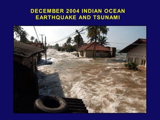
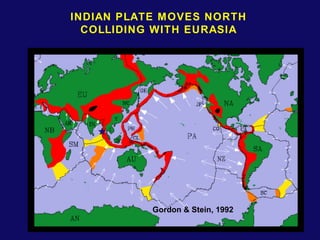
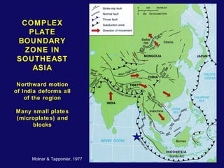
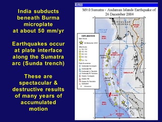
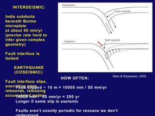
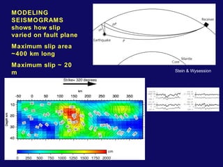
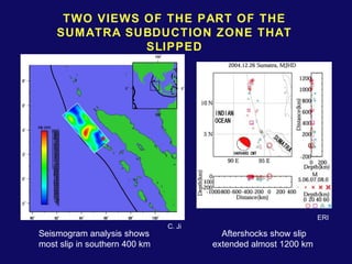
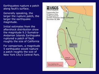
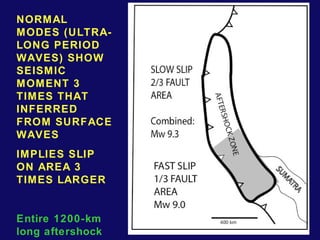
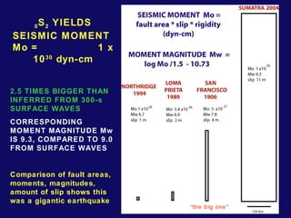
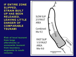
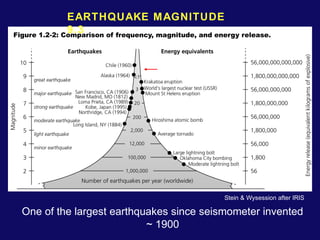
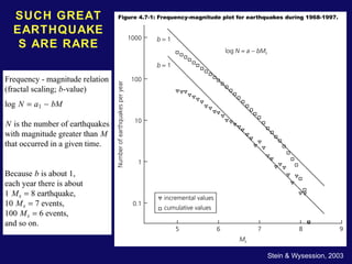
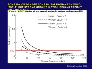
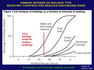
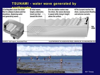
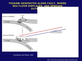
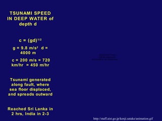
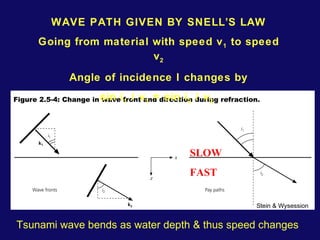
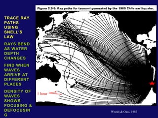
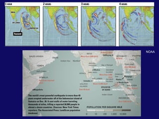
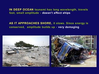
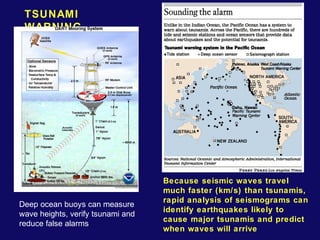
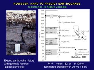
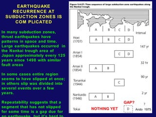
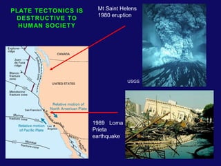
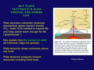
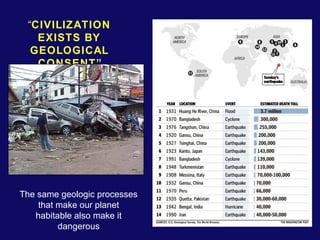
DECEMBER 2004 INDIAN OCEAN 
EARTHQUAKE AND TSUNAMI
BASIC CONCEPTS: RIGID PLATES 
Earth's outer shell made up of ~15 major rigid plates ~ 100 km thick 
Plates move relative to each other at speeds of a few cm/ yr (about 
the speed at which fingernails grow) 
Plates are rigid in the sense that little (ideally no) deformation occurs 
within them, 
Most (ideally all) deformation occurs at their boundaries, giving rise to 
earthquakes, mountain building, volcanism, and other spectacular 
phenomena. 
Style of boundary and intraplate deformation depends on direction & 
rate of motion, together with thermo-mechanical structure
BASIC 
CONCEPTS: 
THERMAL 
EVOLUTION 
OF OCEANIC 
LITHOSPHERE 
Stein & 
Wysession 
2003 
Warm mantle material upwells at spreading centers and then cools 
Because rock strength decreases with temperature, cooling material 
forms strong plates of lithosphere 
Cooling oceanic lithosphere moves away from the ridges, eventually 
reaches subduction zones and descends in downgoing slabs back into 
the mantle, reheating as it goes 
Lithosphere is cold outer boundary layer of thermal convection system 
involving mantle and core that removes heat from Earth's interior, 
controlling its evolution
INDIAN PLATE MOVES NORTH 
COLLIDING WITH EURASIA 
Gordon & Stein, 1992
COMPLEX 
PLATE 
BOUNDARY 
ZONE IN 
SOUTHEAST 
ASIA 
Northward motion 
of India deforms all 
of the region 
Many small plates 
(microplates) and 
blocks 
Molnar & Tapponier, 1977
India subducts 
beneath Burma 
microplate 
at about 50 mm/yr 
Earthquakes occur 
at plate interface 
along the Sumatra 
arc (Sunda trench) 
These are 
spectacular & 
destructive results 
of many years of 
accumulated 
motion
INTERSEISMIC: 
India subducts 
beneath Burma 
microplate 
at about 50 mm/yr 
(precise rate hard to 
infer given complex 
geometry) 
Fault interface is 
locked 
EARTHQUAKE 
(COSEISMIC): 
Fault interface slips, 
overriding plate 
rebounds, releasing 
accumulated motion 
HOW OFTEN: 
Fault slipped ~ 10 m = 10000 mm / 50 mm/yr 
10000 mm / 50 mm/yr = 200 yr 
Longer if some slip is aseismic 
Stein & Wysession, 2003 
Faults aren’t exactly periodic for reasons we don’t 
understand
MODELING 
SEISMOGRAMS 
shows how slip 
varied on fault plane 
Maximum slip area 
~400 km long 
Maximum slip ~ 20 
m Stein & Wysession
TWO VIEWS OF THE PART OF THE 
SUMATRA SUBDUCTION ZONE THAT 
SLIPPED 
Seismogram analysis shows 
most slip in southern 400 km 
Aftershocks show slip 
extended almost 1200 km 
C. Ji 
ERI
Earthquakes rupture a patch 
along fault's surface. 
Generally speaking, the 
larger the rupture patch, the 
larger the earthquake 
magnitude. 
Initial estimates from the 
aftershock distribution show 
the magnitude 9.3 Sumatra- 
Andaman Islands Earthquake 
ruptured a patch of fault 
roughly the size of California 
For comparison, a magnitude 
5 earthquake would rupture 
a patch roughly the size of 
New York City's Central Park.
NORMAL 
MODES (ULTRA-LONG 
PERIOD 
WAVES) SHOW 
SEISMIC 
MOMENT 3 
TIMES THAT 
INFERRED 
FROM SURFACE 
WAVES 
IMPLIES SLIP 
ON AREA 3 
TIMES LARGER 
Entire 1200-km 
long aftershock 
zone likely
0S2 YIELDS 
SEISMIC MOMENT 
Mo = 1 x 
1030 dyn-cm 
2.5 TIMES BIGGER THAN 
INFERRED FROM 300-s 
SURFACE WAVES 
CORRESPONDING 
MOMENT MAGNITUDE Mw 
IS 9.3, COMPARED TO 9.0 
FROM SURFACE WAVES 
Comparison of fault areas, 
moments, magnitudes, 
amount of slip shows this 
was a gigantic earthquake 
“the big one”
IF ENTIRE ZONE 
SLIPPED, 
STRAIN BUILT 
UP HAS BEEN 
RELEASED, 
LEAVING LITTLE 
DANGER OF 
COMPARABLE 
TSUNAMI 
Risk of local tsunami 
from large 
aftershocks or 
oceanwide tsunami 
from boundary 
segments to south 
remains
EARTHQUAKE MAGNITUDE 
9.3 
One of the largest earthquakes since seismometer invented 
~ 1900 
Stein & Wysession after IRIS
SUCH GREAT 
EARTHQUAKE 
S ARE RARE 
Stein & Wysession, 2003
SOME MAJOR DAMAGE DONE BY EARTHQUAKE SHAKING 
ITSELF, BUT STRONG GROUND MOTION DECAYS RAPIDLY 
WITH DISTANCE 
0.2 g 
Stein & Wysession, 2003
DAMAGE DEPENDS ON BUILDING TYPE 
RESISTANT CONSTRUCTION REDUCES EARTHQUAKE RISKS 
0.2 g 
Damage 
onset for 
modern 
buildings 
“Earthquakes don't kill people; buildings kill people." Coburn & 
Spence 1992
TSUNAMI - water wave generated by 
earthquake 
NY Times
TSUNAMI GENERATED ALONG FAULT, WHERE 
SEA FLOOR DISPLACED, AND SPREADS 
OUTWARD 
QuickTime™ and a 
TIFF (LZW) decompressor 
are needed to see this picture. 
Red - up Hyndeman and Wang, 1993 motion, blue down 
http://staff.aist.go.jp/kenji.satake/animation.gif
TSUNAMI SPEED 
IN DEEP WATER of 
depth d 
c = (gd)1/2 
g = 9.8 m/s2 d = 
4000 m 
c = 200 m/s = 720 
km/hr = 450 m/hr 
Tsunami generated 
along fault, where 
sea floor displaced, 
and spreads outward 
Reached Sri Lanka in 
2 hrs, India in 2-3 
QuickTime™ and a 
GIF decompressor 
are needed to see this picture. 
http://staff.aist.go.jp/kenji.satake/animation.gif
WAVE PATH GIVEN BY SNELL’S LAW 
Going from material with speed v1 to speed 
v2 
Angle of incidence I changes by 
sin i1 / v1 = sin i2 / v2 
SLOW 
FAST 
Stein & Wysession 
Tsunami wave bends as water depth & thus speed changes
TRACE RAY 
PATHS 
USING 
SNELL’S 
LAW 
RAYS BEND 
AS WATER 
DEPTH 
CHANGES 
FIND WHEN 
WAVES 
ARRIVE AT 
DIFFERENT 
PLACES 
DENSITY OF 
WAVES 
SHOWS 
FOCUSING & 
DEFOCUSIN 
G 
Woods & Okal, 1987 
1 hour
NOAA
IN DEEP OCEAN tsunami has long wavelength, travels 
fast, small amplitude - doesn’t affect ships 
AS IT APPROACHES SHORE, it slows. Since energy is 
conserved, amplitude builds up - very damaging
Because seismic waves travel 
much faster (km/s) than tsunamis, 
rapid analysis of seismograms can 
identify earthquakes likely to 
cause major tsunamis and predict 
when waves will arrive 
TSUNAMI 
WARNING 
Deep ocean buoys can measure 
wave heights, verify tsunami and 
reduce false alarms
HOWEVER, HARD TO PREDICT EARTHQUAKES 
recurrence is highly variable 
Sieh et al., 1989 
M>7 mean 132 yr s 105 yr 
Estimated probability in 30 yrs 7-51% 
Extend earthquake history 
with geologic records 
-paleoseismology
EARTHQUAKE 
RECURRENCE AT 
SUBDUCTION ZONES IS 
COM PLICATED 
In many subduction zones, 
thrust earthquakes have 
patterns in space and time. 
Large earthquakes occurred in 
the Nankai trough area of 
Japan approximately every 125 
years since 1498 with similar 
fault areas 
In some cases entire region 
seems to have slipped at once; 
in others slip was divided into 
several events over a few 
years. 
Repeatability suggests that a 
segment that has not slipped 
for some time is a gap due for 
an earthquake, but it’s hard to 
GAP? 
NOTHING YET Ando, 1975
EARTHQUAKE PREDICTION? 
Because little is known about the fundamental physics of faulting, many 
attempts to predict earthquakes searched for precursors, observable behavior 
that precedes earthquakes. To date, search has proved generally unsuccessful 
In one hypothesis, all earthquakes start off as tiny earthquakes, which happen 
frequently, but only a few cascade via random failure process into large 
earthquakes 
This hypothesis draws on ideas from nonlinear dynamics or chaos theory, in 
which small perturbations can grow to have unpredictable large consequences. 
These ideas were posed in terms of the possibility that the flap of a butterfly's 
wings in Brazil might set off a tornado in Texas, or in general that minuscule 
disturbances do not affect the overall frequency of storms but can modify when 
they occur 
If so, there is nothing special about those tiny earthquakes that happen to 
grow into large ones, the interval between large earthquakes is highly variable 
and no observable precursors should occur before them. Thus earthquake 
prediction is either impossible or nearly so. 
“It’s hard to predict earthquakes, especially before they happen”
PLATE TECTONICS IS 
DESTRUCTIVE TO 
HUMAN SOCIETY 
Mt Saint Helens 
1980 eruption 
USGS 
1989 Loma 
Prieta 
earthquake
BUT PLATE 
TECTONICS IS ALSO 
CRUCIAL FOR HUMAN 
LIFE 
Plate boundary volcanism produces 
atmospheric gases (carbon dioxide 
CO2 ; water H2O) needed to support life 
and keep planet warm enough for life 
("greenhouse" ) 
May explain how life evolved on earth 
(at midocean ridge hot springs) 
Plate tectonics raises continents above 
sea level 
Plate tectonics produces mineral 
resources including fossil fuels 
Press & Siever
“CIVILIZATION 
EXISTS BY 
GEOLOGICAL 
CONSENT” 
The same geologic processes 
that make our planet 
habitable also make it 
dangerous

Iotsunami

  • 1.
    DECEMBER 2004 INDIANOCEAN EARTHQUAKE AND TSUNAMI
  • 2.
    BASIC CONCEPTS: RIGIDPLATES Earth's outer shell made up of ~15 major rigid plates ~ 100 km thick Plates move relative to each other at speeds of a few cm/ yr (about the speed at which fingernails grow) Plates are rigid in the sense that little (ideally no) deformation occurs within them, Most (ideally all) deformation occurs at their boundaries, giving rise to earthquakes, mountain building, volcanism, and other spectacular phenomena. Style of boundary and intraplate deformation depends on direction & rate of motion, together with thermo-mechanical structure
  • 3.
    BASIC CONCEPTS: THERMAL EVOLUTION OF OCEANIC LITHOSPHERE Stein & Wysession 2003 Warm mantle material upwells at spreading centers and then cools Because rock strength decreases with temperature, cooling material forms strong plates of lithosphere Cooling oceanic lithosphere moves away from the ridges, eventually reaches subduction zones and descends in downgoing slabs back into the mantle, reheating as it goes Lithosphere is cold outer boundary layer of thermal convection system involving mantle and core that removes heat from Earth's interior, controlling its evolution
  • 4.
    INDIAN PLATE MOVESNORTH COLLIDING WITH EURASIA Gordon & Stein, 1992
  • 5.
    COMPLEX PLATE BOUNDARY ZONE IN SOUTHEAST ASIA Northward motion of India deforms all of the region Many small plates (microplates) and blocks Molnar & Tapponier, 1977
  • 6.
    India subducts beneathBurma microplate at about 50 mm/yr Earthquakes occur at plate interface along the Sumatra arc (Sunda trench) These are spectacular & destructive results of many years of accumulated motion
  • 7.
    INTERSEISMIC: India subducts beneath Burma microplate at about 50 mm/yr (precise rate hard to infer given complex geometry) Fault interface is locked EARTHQUAKE (COSEISMIC): Fault interface slips, overriding plate rebounds, releasing accumulated motion HOW OFTEN: Fault slipped ~ 10 m = 10000 mm / 50 mm/yr 10000 mm / 50 mm/yr = 200 yr Longer if some slip is aseismic Stein & Wysession, 2003 Faults aren’t exactly periodic for reasons we don’t understand
  • 8.
    MODELING SEISMOGRAMS showshow slip varied on fault plane Maximum slip area ~400 km long Maximum slip ~ 20 m Stein & Wysession
  • 9.
    TWO VIEWS OFTHE PART OF THE SUMATRA SUBDUCTION ZONE THAT SLIPPED Seismogram analysis shows most slip in southern 400 km Aftershocks show slip extended almost 1200 km C. Ji ERI
  • 10.
    Earthquakes rupture apatch along fault's surface. Generally speaking, the larger the rupture patch, the larger the earthquake magnitude. Initial estimates from the aftershock distribution show the magnitude 9.3 Sumatra- Andaman Islands Earthquake ruptured a patch of fault roughly the size of California For comparison, a magnitude 5 earthquake would rupture a patch roughly the size of New York City's Central Park.
  • 11.
    NORMAL MODES (ULTRA-LONG PERIOD WAVES) SHOW SEISMIC MOMENT 3 TIMES THAT INFERRED FROM SURFACE WAVES IMPLIES SLIP ON AREA 3 TIMES LARGER Entire 1200-km long aftershock zone likely
  • 12.
    0S2 YIELDS SEISMICMOMENT Mo = 1 x 1030 dyn-cm 2.5 TIMES BIGGER THAN INFERRED FROM 300-s SURFACE WAVES CORRESPONDING MOMENT MAGNITUDE Mw IS 9.3, COMPARED TO 9.0 FROM SURFACE WAVES Comparison of fault areas, moments, magnitudes, amount of slip shows this was a gigantic earthquake “the big one”
  • 13.
    IF ENTIRE ZONE SLIPPED, STRAIN BUILT UP HAS BEEN RELEASED, LEAVING LITTLE DANGER OF COMPARABLE TSUNAMI Risk of local tsunami from large aftershocks or oceanwide tsunami from boundary segments to south remains
  • 14.
    EARTHQUAKE MAGNITUDE 9.3 One of the largest earthquakes since seismometer invented ~ 1900 Stein & Wysession after IRIS
  • 15.
    SUCH GREAT EARTHQUAKE S ARE RARE Stein & Wysession, 2003
  • 16.
    SOME MAJOR DAMAGEDONE BY EARTHQUAKE SHAKING ITSELF, BUT STRONG GROUND MOTION DECAYS RAPIDLY WITH DISTANCE 0.2 g Stein & Wysession, 2003
  • 17.
    DAMAGE DEPENDS ONBUILDING TYPE RESISTANT CONSTRUCTION REDUCES EARTHQUAKE RISKS 0.2 g Damage onset for modern buildings “Earthquakes don't kill people; buildings kill people." Coburn & Spence 1992
  • 18.
    TSUNAMI - waterwave generated by earthquake NY Times
  • 19.
    TSUNAMI GENERATED ALONGFAULT, WHERE SEA FLOOR DISPLACED, AND SPREADS OUTWARD QuickTime™ and a TIFF (LZW) decompressor are needed to see this picture. Red - up Hyndeman and Wang, 1993 motion, blue down http://staff.aist.go.jp/kenji.satake/animation.gif
  • 20.
    TSUNAMI SPEED INDEEP WATER of depth d c = (gd)1/2 g = 9.8 m/s2 d = 4000 m c = 200 m/s = 720 km/hr = 450 m/hr Tsunami generated along fault, where sea floor displaced, and spreads outward Reached Sri Lanka in 2 hrs, India in 2-3 QuickTime™ and a GIF decompressor are needed to see this picture. http://staff.aist.go.jp/kenji.satake/animation.gif
  • 21.
    WAVE PATH GIVENBY SNELL’S LAW Going from material with speed v1 to speed v2 Angle of incidence I changes by sin i1 / v1 = sin i2 / v2 SLOW FAST Stein & Wysession Tsunami wave bends as water depth & thus speed changes
  • 22.
    TRACE RAY PATHS USING SNELL’S LAW RAYS BEND AS WATER DEPTH CHANGES FIND WHEN WAVES ARRIVE AT DIFFERENT PLACES DENSITY OF WAVES SHOWS FOCUSING & DEFOCUSIN G Woods & Okal, 1987 1 hour
  • 23.
  • 24.
    IN DEEP OCEANtsunami has long wavelength, travels fast, small amplitude - doesn’t affect ships AS IT APPROACHES SHORE, it slows. Since energy is conserved, amplitude builds up - very damaging
  • 25.
    Because seismic wavestravel much faster (km/s) than tsunamis, rapid analysis of seismograms can identify earthquakes likely to cause major tsunamis and predict when waves will arrive TSUNAMI WARNING Deep ocean buoys can measure wave heights, verify tsunami and reduce false alarms
  • 26.
    HOWEVER, HARD TOPREDICT EARTHQUAKES recurrence is highly variable Sieh et al., 1989 M>7 mean 132 yr s 105 yr Estimated probability in 30 yrs 7-51% Extend earthquake history with geologic records -paleoseismology
  • 27.
    EARTHQUAKE RECURRENCE AT SUBDUCTION ZONES IS COM PLICATED In many subduction zones, thrust earthquakes have patterns in space and time. Large earthquakes occurred in the Nankai trough area of Japan approximately every 125 years since 1498 with similar fault areas In some cases entire region seems to have slipped at once; in others slip was divided into several events over a few years. Repeatability suggests that a segment that has not slipped for some time is a gap due for an earthquake, but it’s hard to GAP? NOTHING YET Ando, 1975
  • 28.
    EARTHQUAKE PREDICTION? Becauselittle is known about the fundamental physics of faulting, many attempts to predict earthquakes searched for precursors, observable behavior that precedes earthquakes. To date, search has proved generally unsuccessful In one hypothesis, all earthquakes start off as tiny earthquakes, which happen frequently, but only a few cascade via random failure process into large earthquakes This hypothesis draws on ideas from nonlinear dynamics or chaos theory, in which small perturbations can grow to have unpredictable large consequences. These ideas were posed in terms of the possibility that the flap of a butterfly's wings in Brazil might set off a tornado in Texas, or in general that minuscule disturbances do not affect the overall frequency of storms but can modify when they occur If so, there is nothing special about those tiny earthquakes that happen to grow into large ones, the interval between large earthquakes is highly variable and no observable precursors should occur before them. Thus earthquake prediction is either impossible or nearly so. “It’s hard to predict earthquakes, especially before they happen”
  • 29.
    PLATE TECTONICS IS DESTRUCTIVE TO HUMAN SOCIETY Mt Saint Helens 1980 eruption USGS 1989 Loma Prieta earthquake
  • 30.
    BUT PLATE TECTONICSIS ALSO CRUCIAL FOR HUMAN LIFE Plate boundary volcanism produces atmospheric gases (carbon dioxide CO2 ; water H2O) needed to support life and keep planet warm enough for life ("greenhouse" ) May explain how life evolved on earth (at midocean ridge hot springs) Plate tectonics raises continents above sea level Plate tectonics produces mineral resources including fossil fuels Press & Siever
  • 31.
    “CIVILIZATION EXISTS BY GEOLOGICAL CONSENT” The same geologic processes that make our planet habitable also make it dangerous

Editor's Notes

  • #15 1906 SF – 4 m of slip on 450-km long fault  3 x 10**16 Joules of elastic energy – equivalent to a 7 Megaton bomb (Hiroshima was 0.012 Mt) 1960 Chile – 21 m of slip on a 800 km long fault  10**19 J of elastic energy (more than a 2000 Mt bomb – larger than all nuclear bombs ever exploded – largest was a Soviet atmospheric test of 58 Mt)