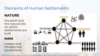
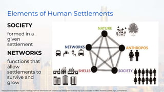
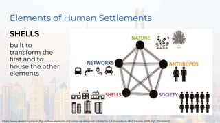
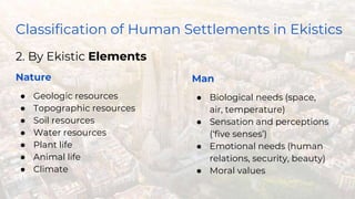
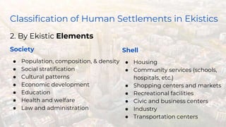
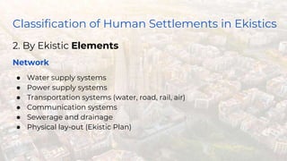
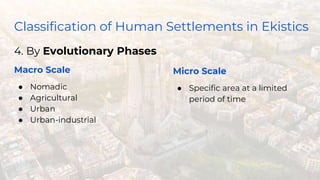
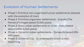
The document discusses the science of human settlements known as Ekistics. It outlines 5 principles that govern the formation of human settlements, which focus on maximizing contacts and minimizing effort. It also describes the 5 elements of human settlements - nature, man, society, shells, and networks. Finally, it discusses the evolution of human settlements from primitive non-organized settlements to the current phase of universal cities.
Doxiadis : Ekistics the science of human settlementHemant Mishra
The document discusses Constantinos Doxiadis and his theory of Ekistics, which is the science of human settlements. Doxiadis believed that populations and energy use in cities would greatly increase in the future. He proposed that all of humanity would eventually live in a single massive "Ecumenopolis," or worldwide city. Doxiadis developed a framework for classifying and understanding the relationships between different elements and scales of human settlements, from individual homes to global urbanization. A key aspect of his theory was that future cities must be planned to accommodate continued population growth and expansion.
The document summarizes several urban planning concepts from the 20th century, including the Garden City Concept, Neighborhood Unit Concept, and Sector Theory. The Garden City Concept proposed limiting city populations and incorporating green spaces. The Neighborhood Unit Concept centered schools and included parks, shops, and distinct internal/perimeter streets. Sector Theory described how distinct land use sectors near the city center would perpetuate as the city expanded in wedge-like fashion along major routes.
Brasília is the planned capital city of Brazil, located in the central highlands. It was designed in the 1950s by urban planner Lúcio Costa and architect Oscar Niemeyer to decentralize Brazil's population and develop its interior. The city is laid out in a pilot plan resembling an airplane, with distinct sectors for administration, commerce, housing and recreation connected by broad avenues. While Brasília succeeded architecturally and symbolically, its utopian social ideals did not fully translate to reality due to high costs and cultural issues. Today it remains an iconic example of modernist urban planning.
Life and Career with works of Constantinos Apostolou Doxiadis. Theory of Urban Design presentation - CA Doxiadis : Ekistics theory, Islamabad master plan, Aspra Spitia introduction, Name of books and journals with bibliography
This document provides information about Sir Patrick Geddes, a Scottish biologist, sociologist, geographer, philanthropist, and pioneering town planner. It discusses his influential thinking in fields like urban planning and sociology. Some of Geddes' key contributions mentioned include introducing the concept of "region" to architecture and planning, coining the term "conurbation" to describe merged urban areas, and founding the Scots College international teaching establishment. The document also outlines some of Geddes' principles for urban planning projects in places like Bombay and his concepts around the relationships between a place, its folk/people, and their work.
Brasilia was designed as Brazil's new capital city in the 1950s to relieve overpopulation pressures in Rio de Janeiro and symbolize Brazil's modernization. Urban planner Lucio Costa's design organized the city into sectors for government, commerce, and residential areas separated by green space. Architect Oscar Niemeyer designed many landmark buildings along the city's central axes. While Brasilia succeeded as a planned city and symbol of national identity, critics argue it lacked consideration for daily life and social integration, with large distances between zones and reliance on cars for transportation.
The document discusses several important planning concepts including:
1) Garden City Concept by Ebenezer Howard which proposed planned, self-contained communities surrounded by greenbelts that combined the benefits of both urban and rural living.
2) Geddesian Triad by Patrick Geddes which emphasized the organic relationship between social, physical, and economic environments in planning.
3) Neighborhood Unit concept by Clarence Perry which proposed planning residential areas with schools, parks, and shops at their core to create self-sufficient neighborhoods.
4) Radburn Concept by Clarence Stein and Henry Wright which pioneered the separation of pedestrian and vehicular traffic in planned communities.
Homer Hoyt developed the sector theory or sector model of urban land use in 1939 as an alternative to the concentric zone model. The sector model posits that a city develops in wedge-shaped sectors centered around major transportation routes rather than concentric circles. Land uses cluster around transportation routes, with industry locating near ports, railroads, or roads. Residential areas then develop, with lower income housing nearer the industrial areas and transportation. Middle and high-income housing is located further out. The model was applied to Chicago and found to accurately describe the city's development around railroad lines.
DOXIADIS
HUMAN SETTLEMENT AND PLANING
CONSTANTINOS APOSTOLOU DOXIADIS
THEORY OF EKISTICS
Minor shells- Micro-settlements- Meso-settlements- Macro-settlements-Ekistics Logarithm Scale:-
BY EVOLUNITARY PHASE
BY FACTOR AND DISCIPLINE
CASE STUDY: ISLAMABAD
Master Plan
Comparison of Land cover
CONCEPT OF CITY PLANNING
ROAD NETWORK & HIERARCHY
ROAD NETWORK & TRANSPORT
HOUSES AND STREET PATTERN
GRID SYSTEM
CURRENT CHALLENGES FACED BY THE CITY
Urban planning theories have evolved over time in response to changes in populations, economies, and technologies. Early theories focused on orderly city layouts with separate zones. Hippodamus proposed dividing cities into public and private areas with grids. Howard's Garden Cities aimed to blend urban and rural advantages. Geddes emphasized relationships between people and environments. Later, modernist planners like Le Corbusier proposed high-density "Radiant Cities." Burgess' concentric zone model depicted socio-economic groups arranged in circles. Perry's neighborhood unit promoted walkable communities. Today, multiple nuclei and sector theories recognize dispersed growth around transportation networks.
Patrick Geddes was a Scottish biologist, sociologist, geographer, philanthropist and pioneering town planner known as the "Father of Modern Town Planning". He introduced concepts like the "region" in architecture and planning. Geddes believed that a region influences and is influenced by the cities within it, represented by his "Geddian Trio" of activity, work, and place. He coined the term "conurbation" to describe merged cities and regions influenced by new transportation technologies. Some of Geddes' plans included the master plan for Tel Aviv which emphasized pedestrians, greenery, and civic spaces. He also developed the "constellation theory" of regional planning around groupings of interconnected cities.
This document does not contain any text to summarize. It only contains the letters "EK", which provides no context or meaning on its own in only two characters. A proper summary requires substantive content to extract and convey the most important ideas, events, or topics in a concise yet informative way.
Homer Hoyt proposed the sector model as an update to the concentric zone model. The sector model accounts for major transportation routes radiating out from the central business district. Land uses, such as industrial, commercial, and residential zones, develop along these transportation corridors in wedge-shaped sectors. The model places low-income housing and industry closest to the central business district, with wealthier residential neighborhoods farther out. Examples of cities that generally follow the sector model include Chicago and Calgary.
Sector and multiple nuclei model presentationaefbraenglish
The sector model developed in 1939 by Homer Hoyt proposes that cities grow outwards from a central business district (CBD) in wedge-shaped sectors determined by factors like transportation routes, with different land uses developing in each sector. For example, in Chicago industry located along rail lines while housing developed north of the CBD. The multiple nuclei model from 1945 argues that cities form around several business centers rather than one CBD, taking into account increased car ownership. Both models have been criticized for not reflecting modern cities and their complexity.
Urban morphology, elements of urban designAbdul Rab
This document provides an overview of urban design topics including urban morphology, elements of urban design, and the nature of urban design projects in public and private developments. It defines urban morphology as the study of the form and development of human settlements. It then discusses some key elements of urban design like buildings, public spaces, streets, transportation, and landscaping. Finally, it describes how urban design projects are carried out through public-private partnerships, with the private sector taking on financial and operational risks and the public sector providing funding or subsidies.
Konstantinos Doxiadis coined the term "ekistics" in 1942 to describe the interdisciplinary study of human settlements at all scales, from individual dwellings to cities to global urbanization. Ekistics examines how settlements are shaped by nature, humans, society, infrastructure, and built structures over time. Doxiadis applied ekistic principles to projects like designing the University of Punjab campus to promote walkability and community interaction, and in developing Baghdad's 1958 master plan with standardized housing types arranged in a rectilinear grid connected by new roads and mixed-use sectors. Ekistics aims to balance influences on settlements and view cities as dynamic entities that allow for continuous growth and change.
Brasilia is a planned city located in the center of Brazil that was designed to be the nation's capital. It was planned by Lúcio Costa with public buildings designed by Oscar Niemeyer. The city's layout is shaped like an airplane, with two main axes intersecting at a central plaza. The plan included superblocks for housing and wide open green spaces. Brasilia was acclaimed for its modernist architecture and utopian design, though it now faces issues with inefficient public transportation and lack of traditional communities as it has grown beyond its original planned population.
GARDEN CITY(garden city concept), the perfect blend of city and nature.
the preservation of agricultural and rural life, nature and heritage conservation, recreation, pollution minimization, and growth management as well as the city endowed the tradition of urban planning with a social and community dimensions.
Theories of Urban Growth Hierarchy and stages of Urban developmentSomesh Siddharth
This document provides an overview of theories of urban growth and development. It discusses natural growth patterns like concentric spread and ribbon development. It also covers the Burgess concentric zone model and Hoyt's sector model. The document contrasts suburban and urban areas based on characteristics like density, land use mix, transportation, and sense of community. It lists notable urban theorists and concepts like new urbanism, placemaking, and infrastructure. Finally, it provides learning objectives and references for further reading on urban morphology.
Urban design is a problem-solving activity that shapes the physical form of cities at all scales. It considers how to create an appropriate physical framework for human activities in cities. The scope of urban design has expanded in response to changes in culture, politics, society and the environment. It draws from theories in urban planning, architecture, and human perception and behavior. Key figures like Jacobs, Lynch, and Rossi influenced urban design to consider aspects like density, land use, collective memory, and the user experience within the built environment. Urban design aims to thoughtfully structure urban form.
The document discusses four key concepts in town planning development:
1) The Garden City Concept from 1902 aims to address overpopulation and congestion through self-sufficient, planned communities of around 32,000 people surrounded by greenbelts.
2) The Neighborhood Unit from the 1920s arranges residential areas around a central hub to improve social conditions and infrastructure, with schools and shops at the center serving around 5,000 people.
3) Parallel Towns from the 1930s focus development along major transportation corridors with housing, industry, and green spaces arranged on either side.
4) Urban Land Use Models from the 19th century propose concentric zoning of land uses from the city center outward, separating residential,
Sir Patrick Geddes was a Scottish biologist, sociologist, geographer, philanthropist and pioneering town planner in the late 19th/early 20th century. He is known for his innovative thinking in fields like urban planning and sociology. Some of his key contributions include introducing the concepts of "region" and "conurbation" to architecture and planning. A conurbation refers to a region comprising cities and towns that have merged due to population growth and expansion. Geddes coined the term and provided examples like the Greater London area. He also developed theories around the relationships between a population ("folk") and their environment ("place") and means of work, which influenced his approach to regional and urban planning.
The document discusses several theories and models of urban and town planning from ancient to modern times. It describes the earliest river valley civilizations and oldest continuously inhabited cities. It then covers concepts in modern town planning like segregating industries, high-rise buildings, and master plans. Various approaches to town planning like rational, incremental, and communicative are mentioned. Models of urban structure and land use are summarized, including central place theory, Ebenezer Howard's three magnets diagram, the garden city movement, concentric zone model, linear city, Radburn superblock, neighborhood unit design, core frame model, sector model, and multiple nuclei model.
Linear City, Garden City, and Broadacre City were three urban planning concepts proposed in the early 20th century. Ebenezer Howard conceived Garden City which proposed self-contained communities surrounded by greenbelts that would relieve overcrowding in cities. Frank Lloyd Wright envisioned Broadacre City which sought to decentralize cities by giving each American family a plot of land to live independently yet collectively on individual homesteads across the country.
An Overview of the City Beautiful Movement - An architectural manifestation of the social response to failing urban life.
Contains details regarding the origin, key characteristics, architects and major cities involved, along with the following case studies :
- Mcmillan Plan
- Plan of Chicago and
- City of Minneapolis.
Brasília was planned and developed in the 1950s as Brazil's new capital city. The city's layout was designed by urban planner Lúcio Costa and resembles an airplane, with a central monumental axis intersecting a curved residential axis. Key features of the plan include superblocks with ample green space, separate networks for vehicles and pedestrians, and a Plaza of Three Powers at the center of government buildings. The goal was to create a modern, planned city that could develop Brazil's central region and serve as a symbol of national pride.
The document is a report about representing a future city. It summarizes investigations into ancient, present and future cities. It then outlines a proposed new flying city called "Stardome" that would avoid issues like earthquakes. The city would have different areas like residential, business and agriculture. Transportation would involve flying vehicles. The report shows the process of developing the initial idea and refining it into the final proposed city design.
On Wednesday, September 7th, Dean Marilyn Jordan Taylor assembled the University of Pennsylvania School of Design community to kick off the academic year.
The document provides an overview of PennDesign's fall 2011 convocation and studio/elective presentations. It lists enrollment numbers and gives a breakdown of students by school. It outlines the international representation in the incoming class and previews the fall lecture series. It then provides summaries of several architecture, landscape architecture, historic preservation, city planning, and fine arts studios, highlighting the themes and projects. Goals for the upcoming year are outlined, focusing on visibility, research, faculty development, curriculum innovation, critical discourse, diversity, administration, and resources.
The document discusses theories of urban growth and urban forms. It summarizes Burgess' concentric zone model which depicts urban land use in concentric rings with the central business district in the middle. It also summarizes Hoyt's sector model and the multiple nuclei model. It then discusses elements of urban form including density, land use, accessibility, urban layout, and building characteristics. Finally, it summarizes several theories of urban growth and development including modernization theory, dependency theory, and world systems theory. It also discusses Rostow's stages of growth theory and provides background on the historical plaza complex in the Philippines.
The document discusses a future city representation project for a class. It begins by introducing the project which asks students to pretend they are the mayor of an existing city ("X" city) that needs to be relocated due to issues. Students must propose a new layout for the city, which could be underground, underwater, floating, or enhanced.
It then provides background information on cities in general, what defines and makes a good city, and defines a future city. It also includes sections summarizing investigations into aspects of ancient Roman cities and data collected about present day London, looking at population, culture, infrastructure, and issues facing inner versus outer London.
This document outlines the planning process for a new town called Valor Town. It begins with an introduction describing the project requirements. It then provides background research on the definitions of towns/cities, guidelines for livable towns, and case studies of ancient, present and future towns. Specifically, it examines the Roman town of Calleva Atrebatum, the German town of Kirchsteigeld, and the English town of Ludlow. It then describes the key characteristics and elements of the new Valor Town, which is planned based on a gridiron system and includes amenities like parks, plazas and sports centers connected by a river transportation system. The conclusion states the new town will have livability benefits based on this planning process
Ch11, Fellman, urban geography, w topics and slides added, classroom use onlyFulton County Schools
AP Human Geography, Northview High School, Fulton County Schools, Classroom Use, Urban Geography, Human Geography, Eleventh Edition, Fellman, Bjelland, Getis, Chapter 11, Urban, Urban-Systems, Urbanization, High School, Advanced-Placement, College-Board
This document presents a report on a proposed new town called Valor Town. It begins with an introduction describing the project requirements to propose a new town layout. It then provides investigations and data collection on ancient, present and future towns. This includes details on the Roman town of Calleva Atrebatum and its grid system, the present German town of Kirchsteigfeld and its open green spaces, and the English town of Ludlow and its eco-park and historic preservation. The document then describes the key characteristics of the new Valor Town, such as its gridiron system, central plaza, parks, and distribution of facilities. It concludes by reflecting on lessons learned about sustainable town planning and layout hierarchies.
This document presents a report on a project to design a new, better livable town. It begins with an introduction to the project requirements and objectives. It then provides investigations and data collection on ancient, present and future towns. This includes details on the Roman town of Calleva Atrebatum and the present town of Kirchsteigfeld, Germany. It also examines the future town of Ludlow, England. Drawing from these case studies, the document then describes the new proposed town of Valor Town. It outlines important characteristics and elements of the new town design, such as a gridiron system, green spaces, and facilities. The conclusion reflects on lessons learned from the project around sustainable town planning and layout.
This document presents a report on the planning and design of a new town called Valor Town. It includes investigations of ancient, present and future towns to inform the design. Ancient Calleva Atrebatum is analyzed for its grid layout and hierarchy. The present German town of Kirchsteigfeld incorporates large green spaces. The future town of Ludlow, England balances heritage and sustainability. Valor Town will apply these lessons, with a gridiron system, central plaza, parks, and green spaces throughout to encourage walking. While more can be improved, the student learned the importance of hierarchy and sustainability in town planning.
The document is a report by a student named Lee Jian Ru about a proposed future city called Neopolis. Some key points:
- Neopolis will be a floating/flying city to address overpopulation and environmental issues on Earth.
- The design of Neopolis is inspired by the futuristic city of Elysium from the movie, featuring advanced medical technology.
- Important characteristics of Neopolis include being surrounded by trees for air quality, placing markets within walking distance to reduce carbon emissions, and using robots for security.
- The conclusion is that Neopolis will provide a sustainable living environment with modern amenities and healthcare, while balancing development and environmental protection.
The document discusses several theorists and concepts related to urban planning and design. It references the works of Jane Jacobs, Oscar Newman, Paul Ritter, and Wilhelm Reich. Some of the key ideas discussed include defining public and private spaces, allowing residents to control areas around their homes, having eyes on the street to increase safety and natural surveillance, and separating motor vehicles from pedestrian paths and gathering spaces.
(Dynapolis,megalopolis and ecumenopolis)Sandhya Sandy
This document discusses concepts related to urban planning including Dynapolis, Megalopolis, and Ecumenopolis. It provides background on Constantinos Doxiadis who coined the term Dynapolis to describe a city that can continuously expand. Examples of Islamabad, Pakistan and its original master plan are given as an implementation of Dynapolis concepts. Megalopolis is defined as a large urban area formed by the connection of multiple cities and metro areas. Examples of megalopolis regions in Europe and their populations are listed. Ecumenopolis refers to the potential future scenario of a single continuous urban area worldwide as a result of population growth and urbanization trends. It is discussed both as a realistic future prediction and
This document provides instructions for a final project to design a new, livable town. It is divided into two parts:
Part A is the individual component where each student investigates elements of towns, researches a type of town, and proposes a basic plan for a hypothetical "X" Town including zoning, transportation, and improvements.
Part B is the group component where students work together to create presentation boards and a physical model for their selected town type.
The project aims to understand natural and built environments, examine past and future towns, and propose a sustainable new town that meets the needs of a population of 80,000-200,000 people through appropriate design considerations.
Ekistics - Defining What is a Polis? What does it consist ofYaryalitsa
1. The document discusses ekistics, which is defined as the science of human settlements. It examines how humans inhabit settlements and provides a conceptual framework for understanding them.
2. Ekistics studies the basic elements that make up human settlements: nature, humans, society, physical structures (shells), and connecting networks.
3. It then presents a classification system of different types of settlements based on population size, ranging from an individual person to a global city. The largest settlements discussed are megacities with populations over 50 million people.
The document discusses plans for a future underground city called Eco-City 2020 located in Siberia, Russia. It would be built inside an abandoned quarry covered by a glass dome. The city would have multiple levels, with housing, forests, farms, and recreation areas. It aims to provide an energy efficient underground living environment that conserves heat and protects residents from harsh weather. Elements that could be used for a new future city include the multi-level layout with a central core and outdoor spaces, as well as the glass dome covering that allows in sunlight.
This document provides an overview of a student's final project proposal for a future floating city called Preciaux. It begins with an introduction and definitions of what constitutes a city and good city design principles. It then examines the urban planning of the ancient city of Tenochtitlan and elements that could be applied to a new future city. Present cities like floating islands in Seoul and the dense planning of Tokyo are also investigated. Concepts for future floating cities like the Lilypad design and sustainable resource-based economy of The Venus Project provide additional inspiration. The proposal will utilize investigations of past, present and future cities to design the new floating city of Preciaux.
This document discusses the importance of STEM and integrating academic and career technical education. It notes that the fundamental question of the 21st century is how to organize and produce innovation. It emphasizes that the key missing literacy is transdisciplinarity and discusses the need to apply problem solving to real world knowledge.
This document provides an overview of Phillip Grasso's education and design work. It outlines his undergraduate degree in Fine Arts from The College of New Jersey and his graduate degree in Architecture from New Jersey Institute of Technology. It then presents several of Grasso's architectural design projects from graduate school, including a Hyde Park pavilion in the UK, a mixed-use midrise development in Brooklyn, a civic community center in Linden, NJ, a collaborative lowrise housing development in Union Beach, NJ, and a movie theater in Williamsburg, Brooklyn. For each project, it provides context, site plans, drawings, and descriptions of the design approach and intent.
Authoring a personal GPT for your research and practice: How we created the Q...Leonel Morgado
Thematic analysis in qualitative research is a time-consuming and systematic task, typically done using teams. Team members must ground their activities on common understandings of the major concepts underlying the thematic analysis, and define criteria for its development. However, conceptual misunderstandings, equivocations, and lack of adherence to criteria are challenges to the quality and speed of this process. Given the distributed and uncertain nature of this process, we wondered if the tasks in thematic analysis could be supported by readily available artificial intelligence chatbots. Our early efforts point to potential benefits: not just saving time in the coding process but better adherence to criteria and grounding, by increasing triangulation between humans and artificial intelligence. This tutorial will provide a description and demonstration of the process we followed, as two academic researchers, to develop a custom ChatGPT to assist with qualitative coding in the thematic data analysis process of immersive learning accounts in a survey of the academic literature: QUAL-E Immersive Learning Thematic Analysis Helper. In the hands-on time, participants will try out QUAL-E and develop their ideas for their own qualitative coding ChatGPT. Participants that have the paid ChatGPT Plus subscription can create a draft of their assistants. The organizers will provide course materials and slide deck that participants will be able to utilize to continue development of their custom GPT. The paid subscription to ChatGPT Plus is not required to participate in this workshop, just for trying out personal GPTs during it.
Unlocking the mysteries of reproduction: Exploring fecundity and gonadosomati...AbdullaAlAsif1
The pygmy halfbeak Dermogenys colletei, is known for its viviparous nature, this presents an intriguing case of relatively low fecundity, raising questions about potential compensatory reproductive strategies employed by this species. Our study delves into the examination of fecundity and the Gonadosomatic Index (GSI) in the Pygmy Halfbeak, D. colletei (Meisner, 2001), an intriguing viviparous fish indigenous to Sarawak, Borneo. We hypothesize that the Pygmy halfbeak, D. colletei, may exhibit unique reproductive adaptations to offset its low fecundity, thus enhancing its survival and fitness. To address this, we conducted a comprehensive study utilizing 28 mature female specimens of D. colletei, carefully measuring fecundity and GSI to shed light on the reproductive adaptations of this species. Our findings reveal that D. colletei indeed exhibits low fecundity, with a mean of 16.76 ± 2.01, and a mean GSI of 12.83 ± 1.27, providing crucial insights into the reproductive mechanisms at play in this species. These results underscore the existence of unique reproductive strategies in D. colletei, enabling its adaptation and persistence in Borneo's diverse aquatic ecosystems, and call for further ecological research to elucidate these mechanisms. This study lends to a better understanding of viviparous fish in Borneo and contributes to the broader field of aquatic ecology, enhancing our knowledge of species adaptations to unique ecological challenges.
EWOCS-I: The catalog of X-ray sources in Westerlund 1 from the Extended Weste...Sérgio Sacani
Context. With a mass exceeding several 104 M⊙ and a rich and dense population of massive stars, supermassive young star clusters
represent the most massive star-forming environment that is dominated by the feedback from massive stars and gravitational interactions
among stars.
Aims. In this paper we present the Extended Westerlund 1 and 2 Open Clusters Survey (EWOCS) project, which aims to investigate
the influence of the starburst environment on the formation of stars and planets, and on the evolution of both low and high mass stars.
The primary targets of this project are Westerlund 1 and 2, the closest supermassive star clusters to the Sun.
Methods. The project is based primarily on recent observations conducted with the Chandra and JWST observatories. Specifically,
the Chandra survey of Westerlund 1 consists of 36 new ACIS-I observations, nearly co-pointed, for a total exposure time of 1 Msec.
Additionally, we included 8 archival Chandra/ACIS-S observations. This paper presents the resulting catalog of X-ray sources within
and around Westerlund 1. Sources were detected by combining various existing methods, and photon extraction and source validation
were carried out using the ACIS-Extract software.
Results. The EWOCS X-ray catalog comprises 5963 validated sources out of the 9420 initially provided to ACIS-Extract, reaching a
photon flux threshold of approximately 2 × 10⁻⁸ photons cm−2
s
−1
. The X-ray sources exhibit a highly concentrated spatial distribution,
with 1075 sources located within the central 1 arcmin. We have successfully detected X-ray emissions from 126 out of the 166 known
massive stars of the cluster, and we have collected over 71 000 photons from the magnetar CXO J164710.20-455217.
The debris of the ‘last major merger’ is dynamically youngSérgio Sacani
The Milky Way’s (MW) inner stellar halo contains an [Fe/H]-rich component with highly eccentric orbits, often referred to as the
‘last major merger.’ Hypotheses for the origin of this component include Gaia-Sausage/Enceladus (GSE), where the progenitor
collided with the MW proto-disc 8–11 Gyr ago, and the Virgo Radial Merger (VRM), where the progenitor collided with the
MW disc within the last 3 Gyr. These two scenarios make different predictions about observable structure in local phase space,
because the morphology of debris depends on how long it has had to phase mix. The recently identified phase-space folds in Gaia
DR3 have positive caustic velocities, making them fundamentally different than the phase-mixed chevrons found in simulations
at late times. Roughly 20 per cent of the stars in the prograde local stellar halo are associated with the observed caustics. Based
on a simple phase-mixing model, the observed number of caustics are consistent with a merger that occurred 1–2 Gyr ago.
We also compare the observed phase-space distribution to FIRE-2 Latte simulations of GSE-like mergers, using a quantitative
measurement of phase mixing (2D causticality). The observed local phase-space distribution best matches the simulated data
1–2 Gyr after collision, and certainly not later than 3 Gyr. This is further evidence that the progenitor of the ‘last major merger’
did not collide with the MW proto-disc at early times, as is thought for the GSE, but instead collided with the MW disc within
the last few Gyr, consistent with the body of work surrounding the VRM.
Immersive Learning That Works: Research Grounding and Paths ForwardLeonel Morgado
We will metaverse into the essence of immersive learning, into its three dimensions and conceptual models. This approach encompasses elements from teaching methodologies to social involvement, through organizational concerns and technologies. Challenging the perception of learning as knowledge transfer, we introduce a 'Uses, Practices & Strategies' model operationalized by the 'Immersive Learning Brain' and ‘Immersion Cube’ frameworks. This approach offers a comprehensive guide through the intricacies of immersive educational experiences and spotlighting research frontiers, along the immersion dimensions of system, narrative, and agency. Our discourse extends to stakeholders beyond the academic sphere, addressing the interests of technologists, instructional designers, and policymakers. We span various contexts, from formal education to organizational transformation to the new horizon of an AI-pervasive society. This keynote aims to unite the iLRN community in a collaborative journey towards a future where immersive learning research and practice coalesce, paving the way for innovative educational research and practice landscapes.
The cost of acquiring information by natural selectionCarl Bergstrom
This is a short talk that I gave at the Banff International Research Station workshop on Modeling and Theory in Population Biology. The idea is to try to understand how the burden of natural selection relates to the amount of information that selection puts into the genome.
It's based on the first part of this research paper:
The cost of information acquisition by natural selection
Ryan Seamus McGee, Olivia Kosterlitz, Artem Kaznatcheev, Benjamin Kerr, Carl T. Bergstrom
bioRxiv 2022.07.02.498577; doi: https://doi.org/10.1101/2022.07.02.498577
hematic appreciation test is a psychological assessment tool used to measure an individual's appreciation and understanding of specific themes or topics. This test helps to evaluate an individual's ability to connect different ideas and concepts within a given theme, as well as their overall comprehension and interpretation skills. The results of the test can provide valuable insights into an individual's cognitive abilities, creativity, and critical thinking skills
The technology uses reclaimed CO₂ as the dyeing medium in a closed loop process. When pressurized, CO₂ becomes supercritical (SC-CO₂). In this state CO₂ has a very high solvent power, allowing the dye to dissolve easily.
Describing and Interpreting an Immersive Learning Case with the Immersion Cub...Leonel Morgado
Current descriptions of immersive learning cases are often difficult or impossible to compare. This is due to a myriad of different options on what details to include, which aspects are relevant, and on the descriptive approaches employed. Also, these aspects often combine very specific details with more general guidelines or indicate intents and rationales without clarifying their implementation. In this paper we provide a method to describe immersive learning cases that is structured to enable comparisons, yet flexible enough to allow researchers and practitioners to decide which aspects to include. This method leverages a taxonomy that classifies educational aspects at three levels (uses, practices, and strategies) and then utilizes two frameworks, the Immersive Learning Brain and the Immersion Cube, to enable a structured description and interpretation of immersive learning cases. The method is then demonstrated on a published immersive learning case on training for wind turbine maintenance using virtual reality. Applying the method results in a structured artifact, the Immersive Learning Case Sheet, that tags the case with its proximal uses, practices, and strategies, and refines the free text case description to ensure that matching details are included. This contribution is thus a case description method in support of future comparative research of immersive learning cases. We then discuss how the resulting description and interpretation can be leveraged to change immersion learning cases, by enriching them (considering low-effort changes or additions) or innovating (exploring more challenging avenues of transformation). The method holds significant promise to support better-grounded research in immersive learning.
ESA/ACT Science Coffee: Diego Blas - Gravitational wave detection with orbita...Advanced-Concepts-Team
Presentation in the Science Coffee of the Advanced Concepts Team of the European Space Agency on the 07.06.2024.
Speaker: Diego Blas (IFAE/ICREA)
Title: Gravitational wave detection with orbital motion of Moon and artificial
Abstract:
In this talk I will describe some recent ideas to find gravitational waves from supermassive black holes or of primordial origin by studying their secular effect on the orbital motion of the Moon or satellites that are laser ranged.
12. Presentation Content
1. Introduction to the Science of Human Settlements
2. Principles on the Creation of Human Settlements
3. Elements of Human Settlements
4. Basic Parts of Composite Human Settlements
5. Classification of Human Settlements
6. Evolution of Human Settlements
13. The Science of Human Settlements
EKISTICS
● starts with the premise that human settlements are
susceptible of systematic investigation
● coined from the Greek words “oikos” (home) and “oiko”
(settling down)
● involves every kind of human settlement, with particular
attention to geography, ecology, human psychology,
anthropology, culture, politics, and occasionally
aesthetics
14. The Science of Human Settlements
CONSTANTINOS A. DOXIADIS
● Greek architect, engineer, and
urban planner
● Chief Town Planning Officer for
the Greater Athens Area in 1937
● Representative of Greece to
England, France, and USA on
postwar reconstruction
● lead architect and planner of
Islamabad, Pakistan
https://www.facebook.com/photo/?fbid=558499929645803&set=a.480611954101268
15. The Science of Human Settlements
EKISTICS as a SCIENCE
● takes into consideration the principles man takes
into account when building his settlements, as well
as the evolution of human settlements through
history in terms of size and quality
● relies on statistics and description, organized in five
ekistic elements or principles: nature, anthropos,
society, shells, and networks
16. The Science of Human Settlements
EKISTICS as a FRAMEWORK
● “Settlements are man's response to
his combined economic, social,
political, technological and cultural
human needs. As a result, man
becomes successful with his
response to this need only if he is
happy and safe within the
settlement that he creates for
himself.”
SETTLEMENTS
MAN
NEEDS
SATISFACTION
17. The Science of Human Settlements
GOALS of EKISTICS
● To build a city of optimum size that considers
human dimensions
● Since there is no point in resisting development, it
should try to accommodate technological
evolution and the needs of man within the same
settlement
18. The Science of Human Settlements
HUMAN SETTLEMENTS
● Settlements inhabited by man
● Cluster of dwellings of any type or size where
human beings live
● Created through movement of man in space and
definition of boundaries of territorial interest for
physical and institutional purposes
19. The Science of Human Settlements
COMPONENTS OF HUMAN SETTLEMENTS
1. The Content
● Man
● Society
● Networks
1. The Container (Physical Settlement)
● Natural elements (Nature)
● Man-made elements (Shell)
20. Principles on the Formation of Human
Settlements
PRINCIPLE NO. 1
● Maximization of man’s potential contacts with the
elements of nature, with other people, and with the
works of man
21. Principles on the Formation of Human
Settlements
PRINCIPLE NO. 2
● Minimization of the effort required for the
achievement of man’s actual and potential
contacts (emphasis on the importance of time
element at this day in age. From “Nomads” to
“Settlers”)
22. Principles on the Formation of Human
Settlements
PRINCIPLE NO. 3
● Optimization of man’s protective space, which
means the selection of such a distance from other
persons, animals, or objects that he can keep his
contacts with them (first principle) without any
kind of sensory or psychological discomfort.
23. Principles on the Formation of Human
Settlements
PRINCIPLE NO. 4
● Optimization of the quality of man’s relationship
with his environment, which consists of nature,
society, shells and networks.
24. Principles on the Formation of Human
Settlements
PRINCIPLE NO. 5
● Man organizes his settlements in an attempt to
achieve an optimum synthesis of the other four
principles, and this optimization is dependent on
time and space, on actual conditions, and on man's
ability to create a synthesis.
25. Elements of Human Settlements
NATURE
the earth and
the natural site
on which
settlements are
built
MAN
creates and
inhabits the
settlements
https://www.researchgate.net/figure/Five-elements-of-Ekistics-as-designed-initially-by-CA-Doxiadis-in-1947-Fookes-2008_fig1_324454600
26. Elements of Human Settlements
SOCIETY
formed in a
given
settlement
NETWORKS
functions that
allow
settlements to
survive and
grow
https://www.researchgate.net/figure/Five-elements-of-Ekistics-as-designed-initially-by-CA-Doxiadis-in-1947-Fookes-2008_fig1_324454600
27. Elements of Human Settlements
SHELLS
built to
transform the
first and to
house the other
elements
https://www.researchgate.net/figure/Five-elements-of-Ekistics-as-designed-initially-by-CA-Doxiadis-in-1947-Fookes-2008_fig1_324454600
28. Basic Parts of Composite Human Settlements
Homogenous Parts
Fields
Central Part
Built-up area
Circulatory Part
Roads and paths within
the fields
https://upload.wikimedia.org/wikipedia/commons/4/45/Intramuros_Manila_1898.jpg
29. Basic Parts of Composite Human Settlements
Special Parts
Monastery, convent, etc.
contained within the
homogenous part
https://upload.wikimedia.org/wikipedia/commons/4/45/Intramuros_Manila_1898.jpg
30. 7 Sacrepante Street
Unit B
Bedroom with a green door
Top bunk
Barangka Ibaba, Mandaluyong
Metro Manila
Philippines
31. Classification of Human Settlements
Based on SIZE (of 5 elements and their combinations with
people and land area)
1) Hamlet to Metropolitan Cities
2) Small and sparsely spaced (rural settlements or
villages specializing in agriculture and other primary
activities)
3) Large and closely spaced (urban settlements
specializing in secondary and tertiary activities)
32. Based on LOCATION OF
SETTLEMENTS – plains,
mountains, coastal, etc.
Based on RELATIONSHIPS
BETWEEN SETTLEMENTS
WITHIN SPACE (hierarchical
or non-hierarchical)
Classification of Human
Settlements
https://i1.wp.com/www.howshewanders.com/wp-content/uploads/2021/09/batad-rice-terraces-3.jpg?w=1000&ssl=1; https://www.tnktravel.com/wp-content/uploads/2017/08/Cai-
Beo-Fishing-Village.jpg; https://www.internetgeography.net/topics/what-is-a-settlement-hierarchy/
33. Based on PHYSICAL
FORMS – form as the
expression of content,
function, and structure.
Based on THE FIVE
ELEMENTS OF HUMAN
SETTLEMENTS
Classification of Human
Settlements
https://teleskola.mt/settlements-3-settlement-patterns/;
34. Classification of Human Settlements
Based on FUNCTIONS or the important understanding of
the meaning and role of settlements
1) They reveal the nature, specialization, and the raison
d’etre of the settlements
2) They can be based on activity (economic, social), their
performance, or their special role (as dormitories,
retirement villages, etc.)
35. Classification of Human Settlements
Based on TIME DIMENSION - the age of settlements, their
place in the continuum (past, present, future), their relative static
or dynamic character, the whole process of their growth
https://www.myleszhang.org/here-grows-new-york-city/
36. Classification of Human Settlements
Based on the DEGREE OF SOCIETY’S CONSCIOUS
INVOLVEMENT in the settlement’s creation – natural
and planned settlements
Based on INSTITUTIONS, LEGISLATION, AND
ADMINISTRATION which society has created for
settlements
37. Classification of Human Settlements in Ekistics
1. By Ekistic Units
2. By Ekistic Elements
3. By Ekistic Functions
4. By Evolutionary Phases
5. By Factors and Disciplines
38. Classification of Human Settlements in Ekistics
1. By Ekistic Units
Physical Units
● Man (as individual) – smallest unit
● Space – second unit which is either personally owned or shared with
others
● Family Home – third unit
Social Unit
● Group of Homes
39. Classification of Human Settlements in Ekistics
1. By Ekistic Units
Ekistic Logarithmic Scale (ELS) consists of 15 Ekistic units
ranging from Man to Ecumenopolis and these units turn into 4 basic
groups
1. Anthropos – 1
2. Room – 2
3. House – 5
4. Housegroup (hamlet) –
40
5. Small neighborhood
(village) – 250
6. Neighborhood – 1,500
7. Small polis (town) –
10,000
8. Polis (city) – 75,000
9. Small metropolis –
500,000
10. Metropolis - 4 million
11. Small Megalopolis – 25
million
12. Megalopolis – 150 million
13. Small eperopolis – 750
million
14. Eperopolis – 7,500 million
15. Ecumenopolis - 50,000
million
40. Classification of Human Settlements in Ekistics
1. By Ekistic Units
Ekistic Logarithmic Scale (ELS)
● Used as a basis for the measurement and
classification of many dimensions in human
settlements
● Also used in geography and regional science
41. Classification of Human Settlements in Ekistics
2. By Ekistic Elements
Nature
● Geologic resources
● Topographic resources
● Soil resources
● Water resources
● Plant life
● Animal life
● Climate
Man
● Biological needs (space,
air, temperature)
● Sensation and perceptions
(‘five senses’)
● Emotional needs (human
relations, security, beauty)
● Moral values
42. Classification of Human Settlements in Ekistics
2. By Ekistic Elements
Society
● Population, composition, & density
● Social stratification
● Cultural patterns
● Economic development
● Education
● Health and welfare
● Law and administration
Shell
● Housing
● Community services (schools,
hospitals, etc.)
● Shopping centers and markets
● Recreational facilities
● Civic and business centers
● Industry
● Transportation centers
43. Classification of Human Settlements in Ekistics
2. By Ekistic Elements
Network
● Water supply systems
● Power supply systems
● Transportation systems (water, road, rail, air)
● Communication systems
● Sewerage and drainage
● Physical lay-out (Ekistic Plan)
44. Classification of Human Settlements in Ekistics
3. By Ekistic Functions
https://www.flexiprep.com/NIOS-Notes/Senior-Secondary/Geography/NIOS-Ch-29-Human-Settlement-Part-3.html
45. Classification of Human Settlements in Ekistics
4. By Evolutionary Phases
Macro Scale
● Nomadic
● Agricultural
● Urban
● Urban-industrial
Micro Scale
● Specific area at a limited
period of time
46. Classification of Human Settlements in Ekistics
4. By Evolutionary Phases and Types of Planning
MICRO SCALE
1. Anthropos –
Architectural
2. Room – Space
3. Dwelling
4. Dwelling Group – Site
Planning
5. Small neighborhood
(village) – Subdivision
Planning
MACRO SCALE
10. Metropolis – Regional Planning
11. Conurbation – Metropolitan
Planning
12. Megalopolis – Terrestrial Planning
13. Urban Region – National Planning
14. Urban Continent – Urban Planning
15. Ecumenopolis – by 2120, global
population ~20B people, and urban
population ~ 18B (Doxiadis)
MIDDLE SCALE
6. Neighborhood
7. Small polis (town) –
Town Planning
8. Polis (city)/Town – City
Planning
9. Large City – Urban
Planning
48. Classification of Human Settlements in Ekistics
Balance between the elements of human settlements
is the goal of EKISTICS which is to deal by necessity
with:
● Nature, which is being spoilt
● Man, who is continuously changing
● Society, which is changing because of man’s new needs
● Shells, which must be constructed
● Networks, which are also changing to cope up with new
demands
49. Evolution of Human Settlements
● Phase 1: Primitive non-organized human settlements (started
with the evolution of man)
● Phase 2: Primitive organized settlements – Eopolis (The
Period of Villages lasted 10,000 years)
● Phase 3: Static urban settlements or cities – Polis (lasted
about 5,000-6,000 years)
● Phase 4: Dynamic urban settlements – Dynapolis lasted 200-
400 years
● Phase 5: Universal City - Ecumenopolis which is now
beginning
51. Evaluation
1. How many principles govern the formation of
human settlements?
2. Enumerate the five elements of human
settlements.
3. [Essay] In maximum of four sentences, what do you
think is the importance of Ekistics and Human
Settlements in studying Architecture?
Editor's Notes
Ask a student what year they are/whether they already have taken planning subjects
Ask the class if they are ready to begin - start in a few moments
Greetings - good morning and thank you to Ar Vocal, the students, and everyone present for giving me the time, privilege, and opportunity to undergo this teaching demo.
I will be discussing one of the modules culled from one of the fundamental subjects I took in pursuit of a postgraduate diploma at the School of Urban and Regional Planning in UP Diliman. I have been a student there for the past 2 years, while maintaining a full time job as a real estate broker and appraiser in a commercial real estate brokerage firm in Makati. Before that, I worked as an international marketing officer of a major property developer and as an architect under the Department of Health. I have two bachelor’s degrees–BS Architecture in Bicol University and BS Real Estate Management in Lyceum of Alabang. I passed the PRC licensure examination three times already and placed on top twice; and is currently on my way to getting a postgraduate diploma for urban and regional planning in UP Diliman.
Generally all settlements, from primitive to most elaborate, from old to new, from small to big, from temporary to permanent, from single to composite