SlideShare a Scribd company logo
Brief History of North American Vertical Datums Mean Sea Level Datum 1900 United States Lake Survey 1903 *Mean Sea Level Datum 1929 United States Lake Survey 1935 International Great Lakes Datum 1955 *National Geodetic Vertical Datum 1929 **International Great Lakes Datum 1985 **North American Vertical Datum 1988
Early vertical datums were established for charting & hydrographic surveys of harbors along the eastern seaboard of the U.S.
The first leveling route in the United States of geodetic quality was established in 1856 – 1857 by the U.S. Coast Survey. ,[object Object],[object Object],[object Object]
Description of Historical Datums ,[object Object],[object Object],[object Object]
Adjustments to North American vertical datum based on   increased   tidal observations Year of  Adjustment Kilometers of  Leveling Number of  Tide Stations 1900 1903 1907 1912 1929 21,095 31,789 38,359 46,468           75,159 (U.S.)               31,565 (Canada) 5 8 8 9         21 (U.S.)               5 (Canada)
NGVD - 1929 ,[object Object],[object Object],[object Object]
Typical Tide Gauge Diagram
Tide Gauge Recorder – circa 1925
Typical Modern Tide Gauge Station Diagram
Tide Gauge – Anchorage, Alaska - 1913
NGVD - 1929 ,[object Object],[object Object],[object Object]
Basic Tide Phases & Cycles
Tidal Definitions ,[object Object],[object Object],[object Object]
Tidal Observations ,[object Object],[object Object],[object Object]
Mixed Tide at Pass Cavallo – May 23 rd  to 24 th  , 2005
Mean Sea Level Trend – Galveston Gauge 8771450 - Galveston Pier 21   mean sea level trend is ~ + 6.5 mm – per year  ( 2.13 feet per century) Mean Sea Level Data from 1908 to 1999
Change in Global Mean Sea Level
Why change from NGVD–29 to NAVD - 88 ,[object Object],[object Object],[object Object]
NAVD-88 ,[object Object],[object Object],[object Object],[object Object]
NAVD-88 ,[object Object],[object Object],[object Object]
NGVD-29 to NAVD-88 Differences ,[object Object],[object Object],[object Object]
NGVD-29 to NAVD-88 Differences
NGVD-29 to NAVD-88 Height Differences units in centimeters
KP0037  DESIGNATION -  A 42 KP0037  PID  -  KP0037 KP0037  STATE/COUNTY-  NV/WHITE PINE KP0037  USGS QUAD  -  HOGUM (1987) KP0037 KP0037  *CURRENT SURVEY CONTROL KP0037  ___________________________________________________________________ KP0037* NAD 83(1986)-  39 04 07.  (N)  114 27 07.  (W)  SCALED  KP0037* NAVD 88  -  1747.784  (meters)  5734.19  (feet)  ADJUSTED  KP0037  ___________________________________________________________________ KP0037  GEOID HEIGHT-  -20.69  (meters)  GEOID03 KP0037  DYNAMIC HT  -  1745.927 (meters)  5728.10  (feet)  COMP KP0037  MODELED GRAV-  979,504.0  (mgal)  NAVD 88 KP0037 KP0037  VERT ORDER  -  FIRST  CLASS II KP0037.The orthometric height was determined by differential leveling KP0037.and adjusted by the National Geodetic Survey in June 1991. KP0037 KP0037.The geoid height was determined by GEOID03. KP0037 KP0037.The modeled gravity was interpolated from observed gravity values. KP0037  SUPERSEDED SURVEY CONTROL KP0037  NGVD 29 (??/??/92) 1746.576  (m)  5730.22  (f) ADJ UNCH  1 2 KP0037 KP0037.Superseded values are not recommended for survey control.
Gravitational Effects on Leveling – Distortions in the NGVD-29 network Leveled Height Differences B A C Topography
Transferring the elevation from a tide gauge to nearby benchmarks – Alaska - 1915
Leveling crew - Navajo Springs, Arizona - 1921
Benchmark crew - Utah, 1934
Leveling crew - rural Mississippi - 1935
Leveling crew – Whisky Pass, Colorado - 1931
Leveling crew – Salmon River, Idaho - 1945
Extending the Network – NGVD- 29 – Vertical control in the United States as of 1936
Closure Standards for Vertical Control [ error of closure - closed level loops ] ,[object Object],[object Object],[object Object],[object Object],[object Object]
 

More Related Content

What's hot

8 Kapasitansi
8 Kapasitansi8 Kapasitansi
8 Kapasitansi
Simon Patabang
 
Induksi elektromagnetik
Induksi elektromagnetikInduksi elektromagnetik
Induksi elektromagnetik
BudiChel1
 
Laporan modul 7 (rangkaian seri rlc)
Laporan modul 7 (rangkaian seri rlc)Laporan modul 7 (rangkaian seri rlc)
Laporan modul 7 (rangkaian seri rlc)
FEmi1710
 
Susunan Inti dan Sifat Inti
Susunan Inti dan Sifat IntiSusunan Inti dan Sifat Inti
Susunan Inti dan Sifat Inti
Fita Permata
 
PPT LISTRIK STATIS KELAS XII SEMESTER 1.pptx
PPT LISTRIK STATIS KELAS XII SEMESTER 1.pptxPPT LISTRIK STATIS KELAS XII SEMESTER 1.pptx
PPT LISTRIK STATIS KELAS XII SEMESTER 1.pptx
materipptgc
 
Sifat partikel dan gelombang
Sifat partikel dan gelombangSifat partikel dan gelombang
Sifat partikel dan gelombang
SMA Negeri 9 KERINCI
 
Rangkaian RC dan RL (Tanpa Sumber)
Rangkaian RC dan RL (Tanpa Sumber)Rangkaian RC dan RL (Tanpa Sumber)
Rangkaian RC dan RL (Tanpa Sumber)
Pamor Gunoto
 
FISIKA LISTRIK STATIS KELAS 12 MIPA 6 SMAN 7 TANGERANG
FISIKA LISTRIK STATIS KELAS 12 MIPA 6 SMAN 7 TANGERANGFISIKA LISTRIK STATIS KELAS 12 MIPA 6 SMAN 7 TANGERANG
FISIKA LISTRIK STATIS KELAS 12 MIPA 6 SMAN 7 TANGERANG
Astari Sari
 
Fisika vektor
Fisika vektorFisika vektor
Fisika vektor
Arya Ananda
 
Energi Potensial dan Potensial Listrik
Energi Potensial dan Potensial ListrikEnergi Potensial dan Potensial Listrik
Energi Potensial dan Potensial Listrik
Dyah Puspagarini
 
Fisika Inti
Fisika IntiFisika Inti
Fisika Inti
FKIP UHO
 
Fisika Inti
Fisika Inti Fisika Inti
Fisika Inti
FKIP UHO
 
Bab.9 sistem koordinasi
Bab.9 sistem koordinasiBab.9 sistem koordinasi
Bab.9 sistem koordinasi
alloysius02
 
Perbedaan fisika klasik dengan fisika kuantum
Perbedaan fisika klasik dengan fisika kuantumPerbedaan fisika klasik dengan fisika kuantum
Perbedaan fisika klasik dengan fisika kuantumSmile Fiz
 
Power Point (Gejala Gelombang)
Power Point (Gejala Gelombang)Power Point (Gejala Gelombang)
Power Point (Gejala Gelombang)Fefi Puspitasari
 
Hukum biot savart
Hukum biot savartHukum biot savart
Hukum biot savart
Wes Karni
 
Ppt 2 difraksi kristal dan kisi balik
Ppt 2 difraksi kristal dan kisi balikPpt 2 difraksi kristal dan kisi balik
Ppt 2 difraksi kristal dan kisi balik
windyramadhani52
 
Model inti atom (asti dewi n.)
Model inti atom (asti dewi n.)Model inti atom (asti dewi n.)
Model inti atom (asti dewi n.)
kemenag
 
Gaya lorentz
Gaya lorentzGaya lorentz

What's hot (20)

8 Kapasitansi
8 Kapasitansi8 Kapasitansi
8 Kapasitansi
 
Induksi elektromagnetik
Induksi elektromagnetikInduksi elektromagnetik
Induksi elektromagnetik
 
Laporan modul 7 (rangkaian seri rlc)
Laporan modul 7 (rangkaian seri rlc)Laporan modul 7 (rangkaian seri rlc)
Laporan modul 7 (rangkaian seri rlc)
 
Susunan Inti dan Sifat Inti
Susunan Inti dan Sifat IntiSusunan Inti dan Sifat Inti
Susunan Inti dan Sifat Inti
 
PPT LISTRIK STATIS KELAS XII SEMESTER 1.pptx
PPT LISTRIK STATIS KELAS XII SEMESTER 1.pptxPPT LISTRIK STATIS KELAS XII SEMESTER 1.pptx
PPT LISTRIK STATIS KELAS XII SEMESTER 1.pptx
 
Sifat partikel dan gelombang
Sifat partikel dan gelombangSifat partikel dan gelombang
Sifat partikel dan gelombang
 
Rangkaian RC dan RL (Tanpa Sumber)
Rangkaian RC dan RL (Tanpa Sumber)Rangkaian RC dan RL (Tanpa Sumber)
Rangkaian RC dan RL (Tanpa Sumber)
 
FISIKA LISTRIK STATIS KELAS 12 MIPA 6 SMAN 7 TANGERANG
FISIKA LISTRIK STATIS KELAS 12 MIPA 6 SMAN 7 TANGERANGFISIKA LISTRIK STATIS KELAS 12 MIPA 6 SMAN 7 TANGERANG
FISIKA LISTRIK STATIS KELAS 12 MIPA 6 SMAN 7 TANGERANG
 
Fisika vektor
Fisika vektorFisika vektor
Fisika vektor
 
Energi Potensial dan Potensial Listrik
Energi Potensial dan Potensial ListrikEnergi Potensial dan Potensial Listrik
Energi Potensial dan Potensial Listrik
 
Fisika Inti
Fisika IntiFisika Inti
Fisika Inti
 
Fisika Inti
Fisika Inti Fisika Inti
Fisika Inti
 
Bab.9 sistem koordinasi
Bab.9 sistem koordinasiBab.9 sistem koordinasi
Bab.9 sistem koordinasi
 
2. Medan magnet
2. Medan magnet2. Medan magnet
2. Medan magnet
 
Perbedaan fisika klasik dengan fisika kuantum
Perbedaan fisika klasik dengan fisika kuantumPerbedaan fisika klasik dengan fisika kuantum
Perbedaan fisika klasik dengan fisika kuantum
 
Power Point (Gejala Gelombang)
Power Point (Gejala Gelombang)Power Point (Gejala Gelombang)
Power Point (Gejala Gelombang)
 
Hukum biot savart
Hukum biot savartHukum biot savart
Hukum biot savart
 
Ppt 2 difraksi kristal dan kisi balik
Ppt 2 difraksi kristal dan kisi balikPpt 2 difraksi kristal dan kisi balik
Ppt 2 difraksi kristal dan kisi balik
 
Model inti atom (asti dewi n.)
Model inti atom (asti dewi n.)Model inti atom (asti dewi n.)
Model inti atom (asti dewi n.)
 
Gaya lorentz
Gaya lorentzGaya lorentz
Gaya lorentz
 

Viewers also liked

History Of North American Datums
History Of North American DatumsHistory Of North American Datums
History Of North American Datums
RHC2008
 
2012 PLSC Track, Datums and tools to connect geospatial data accurately, Pame...
2012 PLSC Track, Datums and tools to connect geospatial data accurately, Pame...2012 PLSC Track, Datums and tools to connect geospatial data accurately, Pame...
2012 PLSC Track, Datums and tools to connect geospatial data accurately, Pame...
GIS in the Rockies
 
Unit4 in Central Government
Unit4 in Central GovernmentUnit4 in Central Government
Unit4 in Central Government
Unit4
 
Writing An Introduction
Writing An IntroductionWriting An Introduction
Writing An Introduction
babybunini
 
The Defense Industry In Western Central Pennsylvania
The Defense Industry In Western Central PennsylvaniaThe Defense Industry In Western Central Pennsylvania
The Defense Industry In Western Central Pennsylvania
Bob Shark
 
Web Configurator
Web ConfiguratorWeb Configurator
Web Configuratormikuzz
 
Ipsos store brands muscle in May 2012
Ipsos store brands muscle in May 2012Ipsos store brands muscle in May 2012
Ipsos store brands muscle in May 2012
Damjana Kocjanc
 
7+1 myths about presentation
7+1 myths about presentation 7+1 myths about presentation
7+1 myths about presentation
Samuel Titěra
 
F Business Presentatie 180609 Final
F Business Presentatie 180609 FinalF Business Presentatie 180609 Final
F Business Presentatie 180609 Final
Patrick Terranea
 
Bgs120 debopriyo roy
Bgs120 debopriyo royBgs120 debopriyo roy
Bgs120 debopriyo roy
Debopriyo Roy
 
ABTCP-Tappi Presentation 2010
ABTCP-Tappi Presentation 2010ABTCP-Tappi Presentation 2010
ABTCP-Tappi Presentation 2010
SteveScheibe
 
Model Organism Linked Data
Model Organism Linked DataModel Organism Linked Data
Model Organism Linked Data
Michel Dumontier
 
Blerta Interpreter 1
Blerta Interpreter 1Blerta Interpreter 1
Blerta Interpreter 1
Blerta
 
Gladneyfinal
GladneyfinalGladneyfinal
Gladneyfinal
Patrick Gladney
 
CSS Information
CSS InformationCSS Information
CSS Information
Crawford6003
 
IVI Program, 'Scaling Up Entrepreneurship,' progam description
IVI Program, 'Scaling Up Entrepreneurship,' progam descriptionIVI Program, 'Scaling Up Entrepreneurship,' progam description
IVI Program, 'Scaling Up Entrepreneurship,' progam description
Thomas Nastas
 
UTA2003
UTA2003UTA2003
UTA2003
janfiga
 
Diap.De Realidad
Diap.De RealidadDiap.De Realidad
Diap.De Realidad
c4chorr0
 
MSP-AzureDev101
MSP-AzureDev101MSP-AzureDev101
MSP-AzureDev101
Dominic Green
 
Going the extra mile in designing for the web
Going the extra mile in designing for the webGoing the extra mile in designing for the web
Going the extra mile in designing for the web
Home
 

Viewers also liked (20)

History Of North American Datums
History Of North American DatumsHistory Of North American Datums
History Of North American Datums
 
2012 PLSC Track, Datums and tools to connect geospatial data accurately, Pame...
2012 PLSC Track, Datums and tools to connect geospatial data accurately, Pame...2012 PLSC Track, Datums and tools to connect geospatial data accurately, Pame...
2012 PLSC Track, Datums and tools to connect geospatial data accurately, Pame...
 
Unit4 in Central Government
Unit4 in Central GovernmentUnit4 in Central Government
Unit4 in Central Government
 
Writing An Introduction
Writing An IntroductionWriting An Introduction
Writing An Introduction
 
The Defense Industry In Western Central Pennsylvania
The Defense Industry In Western Central PennsylvaniaThe Defense Industry In Western Central Pennsylvania
The Defense Industry In Western Central Pennsylvania
 
Web Configurator
Web ConfiguratorWeb Configurator
Web Configurator
 
Ipsos store brands muscle in May 2012
Ipsos store brands muscle in May 2012Ipsos store brands muscle in May 2012
Ipsos store brands muscle in May 2012
 
7+1 myths about presentation
7+1 myths about presentation 7+1 myths about presentation
7+1 myths about presentation
 
F Business Presentatie 180609 Final
F Business Presentatie 180609 FinalF Business Presentatie 180609 Final
F Business Presentatie 180609 Final
 
Bgs120 debopriyo roy
Bgs120 debopriyo royBgs120 debopriyo roy
Bgs120 debopriyo roy
 
ABTCP-Tappi Presentation 2010
ABTCP-Tappi Presentation 2010ABTCP-Tappi Presentation 2010
ABTCP-Tappi Presentation 2010
 
Model Organism Linked Data
Model Organism Linked DataModel Organism Linked Data
Model Organism Linked Data
 
Blerta Interpreter 1
Blerta Interpreter 1Blerta Interpreter 1
Blerta Interpreter 1
 
Gladneyfinal
GladneyfinalGladneyfinal
Gladneyfinal
 
CSS Information
CSS InformationCSS Information
CSS Information
 
IVI Program, 'Scaling Up Entrepreneurship,' progam description
IVI Program, 'Scaling Up Entrepreneurship,' progam descriptionIVI Program, 'Scaling Up Entrepreneurship,' progam description
IVI Program, 'Scaling Up Entrepreneurship,' progam description
 
UTA2003
UTA2003UTA2003
UTA2003
 
Diap.De Realidad
Diap.De RealidadDiap.De Realidad
Diap.De Realidad
 
MSP-AzureDev101
MSP-AzureDev101MSP-AzureDev101
MSP-AzureDev101
 
Going the extra mile in designing for the web
Going the extra mile in designing for the webGoing the extra mile in designing for the web
Going the extra mile in designing for the web
 

Similar to History Of North American Vertical Datums

From the Arctic to the Tropics: The U.S. UNCLOS Bathymetric Mapping Program
From the Arctic to the Tropics: The U.S. UNCLOS Bathymetric Mapping ProgramFrom the Arctic to the Tropics: The U.S. UNCLOS Bathymetric Mapping Program
From the Arctic to the Tropics: The U.S. UNCLOS Bathymetric Mapping Program
Larry Mayer
 
The Effect of Declination on The Tide Pattern in Hydroghraphic Surveying
The Effect of Declination on The Tide Pattern in Hydroghraphic SurveyingThe Effect of Declination on The Tide Pattern in Hydroghraphic Surveying
The Effect of Declination on The Tide Pattern in Hydroghraphic Surveying
Nzar Braim
 
Grace satellite technology
Grace satellite technologyGrace satellite technology
Grace satellite technology
dzbsjk
 
WEEK 16 & 17 TOPIC 2 PUBLICATION FOR PREDICTING TIDES AND CURRENTS.pptx
WEEK 16 & 17 TOPIC 2 PUBLICATION FOR PREDICTING TIDES AND CURRENTS.pptxWEEK 16 & 17 TOPIC 2 PUBLICATION FOR PREDICTING TIDES AND CURRENTS.pptx
WEEK 16 & 17 TOPIC 2 PUBLICATION FOR PREDICTING TIDES AND CURRENTS.pptx
AlanLeeMoreno
 
Larsen ice shelf has progressively thinned
Larsen ice shelf has progressively thinnedLarsen ice shelf has progressively thinned
Larsen ice shelf has progressively thinned
SimoneBoccuccia
 
Lecture13 oct23-bb(1)
Lecture13 oct23-bb(1)Lecture13 oct23-bb(1)
Lecture13 oct23-bb(1)
Peter Shiv
 
Mercator Ocean newsletter 11
Mercator Ocean newsletter 11Mercator Ocean newsletter 11
Mercator Ocean newsletter 11
Mercator Ocean International
 
Boothroyd climate change-symposium-18nov2011-final
Boothroyd climate change-symposium-18nov2011-finalBoothroyd climate change-symposium-18nov2011-final
Boothroyd climate change-symposium-18nov2011-final
riseagrant
 
Gowanus Canal Survey Report - Single Beam Echo Sounders
Gowanus Canal Survey Report - Single Beam Echo SoundersGowanus Canal Survey Report - Single Beam Echo Sounders
Gowanus Canal Survey Report - Single Beam Echo Sounders
SyQwest Inc.
 
Circulation of the North Atlantic Ocean During the 1990's as Determine by Lag...
Circulation of the North Atlantic Ocean During the 1990's as Determine by Lag...Circulation of the North Atlantic Ocean During the 1990's as Determine by Lag...
Circulation of the North Atlantic Ocean During the 1990's as Determine by Lag...
David Fratantoni
 
Saildrone Antarctica Mission
Saildrone Antarctica MissionSaildrone Antarctica Mission
Saildrone Antarctica Mission
Matthieu LIENART
 
PNG coastal upwelling, ENSO, SPICE, R/V Mirai observation: UPNG presentation ...
PNG coastal upwelling, ENSO, SPICE, R/V Mirai observation: UPNG presentation ...PNG coastal upwelling, ENSO, SPICE, R/V Mirai observation: UPNG presentation ...
PNG coastal upwelling, ENSO, SPICE, R/V Mirai observation: UPNG presentation ...
Takuya HASEGAWA
 
GeoTool_2015_Coastal_Data_Application_BWang_Final
GeoTool_2015_Coastal_Data_Application_BWang_FinalGeoTool_2015_Coastal_Data_Application_BWang_Final
GeoTool_2015_Coastal_Data_Application_BWang_Final
Bin Wang
 
Moin CR Italy_Gath LR
Moin CR Italy_Gath LRMoin CR Italy_Gath LR
Moin CR Italy_Gath LR
Eldon Gath
 
Simulating hydrologic response to climate change and drought with an integrat...
Simulating hydrologic response to climate change and drought with an integrat...Simulating hydrologic response to climate change and drought with an integrat...
Simulating hydrologic response to climate change and drought with an integrat...
Dirk Kassenaar M.Sc. P.Eng.
 
Hydrography is the branch of applied science which deals with the measurement...
Hydrography is the branch of applied science which deals with the measurement...Hydrography is the branch of applied science which deals with the measurement...
Hydrography is the branch of applied science which deals with the measurement...
Hafez Ahmad
 
Meteorology presentation.pptx lates
Meteorology presentation.pptx latesMeteorology presentation.pptx lates
Meteorology presentation.pptx lates
jabbar2002pk200
 
Presentation: Volcanic Monitoring with GPS--An Alaskan Example
Presentation: Volcanic Monitoring with GPS--An Alaskan ExamplePresentation: Volcanic Monitoring with GPS--An Alaskan Example
Presentation: Volcanic Monitoring with GPS--An Alaskan Example
SERC at Carleton College
 
Page 83 Introductory GeoloGy Plate tectonIcs4.11 sTu.docx
Page  83 Introductory GeoloGy Plate tectonIcs4.11 sTu.docxPage  83 Introductory GeoloGy Plate tectonIcs4.11 sTu.docx
Page 83 Introductory GeoloGy Plate tectonIcs4.11 sTu.docx
gerardkortney
 
Poster 2 (landscape)
Poster 2 (landscape)Poster 2 (landscape)
Poster 2 (landscape)
Emma Reynolds
 

Similar to History Of North American Vertical Datums (20)

From the Arctic to the Tropics: The U.S. UNCLOS Bathymetric Mapping Program
From the Arctic to the Tropics: The U.S. UNCLOS Bathymetric Mapping ProgramFrom the Arctic to the Tropics: The U.S. UNCLOS Bathymetric Mapping Program
From the Arctic to the Tropics: The U.S. UNCLOS Bathymetric Mapping Program
 
The Effect of Declination on The Tide Pattern in Hydroghraphic Surveying
The Effect of Declination on The Tide Pattern in Hydroghraphic SurveyingThe Effect of Declination on The Tide Pattern in Hydroghraphic Surveying
The Effect of Declination on The Tide Pattern in Hydroghraphic Surveying
 
Grace satellite technology
Grace satellite technologyGrace satellite technology
Grace satellite technology
 
WEEK 16 & 17 TOPIC 2 PUBLICATION FOR PREDICTING TIDES AND CURRENTS.pptx
WEEK 16 & 17 TOPIC 2 PUBLICATION FOR PREDICTING TIDES AND CURRENTS.pptxWEEK 16 & 17 TOPIC 2 PUBLICATION FOR PREDICTING TIDES AND CURRENTS.pptx
WEEK 16 & 17 TOPIC 2 PUBLICATION FOR PREDICTING TIDES AND CURRENTS.pptx
 
Larsen ice shelf has progressively thinned
Larsen ice shelf has progressively thinnedLarsen ice shelf has progressively thinned
Larsen ice shelf has progressively thinned
 
Lecture13 oct23-bb(1)
Lecture13 oct23-bb(1)Lecture13 oct23-bb(1)
Lecture13 oct23-bb(1)
 
Mercator Ocean newsletter 11
Mercator Ocean newsletter 11Mercator Ocean newsletter 11
Mercator Ocean newsletter 11
 
Boothroyd climate change-symposium-18nov2011-final
Boothroyd climate change-symposium-18nov2011-finalBoothroyd climate change-symposium-18nov2011-final
Boothroyd climate change-symposium-18nov2011-final
 
Gowanus Canal Survey Report - Single Beam Echo Sounders
Gowanus Canal Survey Report - Single Beam Echo SoundersGowanus Canal Survey Report - Single Beam Echo Sounders
Gowanus Canal Survey Report - Single Beam Echo Sounders
 
Circulation of the North Atlantic Ocean During the 1990's as Determine by Lag...
Circulation of the North Atlantic Ocean During the 1990's as Determine by Lag...Circulation of the North Atlantic Ocean During the 1990's as Determine by Lag...
Circulation of the North Atlantic Ocean During the 1990's as Determine by Lag...
 
Saildrone Antarctica Mission
Saildrone Antarctica MissionSaildrone Antarctica Mission
Saildrone Antarctica Mission
 
PNG coastal upwelling, ENSO, SPICE, R/V Mirai observation: UPNG presentation ...
PNG coastal upwelling, ENSO, SPICE, R/V Mirai observation: UPNG presentation ...PNG coastal upwelling, ENSO, SPICE, R/V Mirai observation: UPNG presentation ...
PNG coastal upwelling, ENSO, SPICE, R/V Mirai observation: UPNG presentation ...
 
GeoTool_2015_Coastal_Data_Application_BWang_Final
GeoTool_2015_Coastal_Data_Application_BWang_FinalGeoTool_2015_Coastal_Data_Application_BWang_Final
GeoTool_2015_Coastal_Data_Application_BWang_Final
 
Moin CR Italy_Gath LR
Moin CR Italy_Gath LRMoin CR Italy_Gath LR
Moin CR Italy_Gath LR
 
Simulating hydrologic response to climate change and drought with an integrat...
Simulating hydrologic response to climate change and drought with an integrat...Simulating hydrologic response to climate change and drought with an integrat...
Simulating hydrologic response to climate change and drought with an integrat...
 
Hydrography is the branch of applied science which deals with the measurement...
Hydrography is the branch of applied science which deals with the measurement...Hydrography is the branch of applied science which deals with the measurement...
Hydrography is the branch of applied science which deals with the measurement...
 
Meteorology presentation.pptx lates
Meteorology presentation.pptx latesMeteorology presentation.pptx lates
Meteorology presentation.pptx lates
 
Presentation: Volcanic Monitoring with GPS--An Alaskan Example
Presentation: Volcanic Monitoring with GPS--An Alaskan ExamplePresentation: Volcanic Monitoring with GPS--An Alaskan Example
Presentation: Volcanic Monitoring with GPS--An Alaskan Example
 
Page 83 Introductory GeoloGy Plate tectonIcs4.11 sTu.docx
Page  83 Introductory GeoloGy Plate tectonIcs4.11 sTu.docxPage  83 Introductory GeoloGy Plate tectonIcs4.11 sTu.docx
Page 83 Introductory GeoloGy Plate tectonIcs4.11 sTu.docx
 
Poster 2 (landscape)
Poster 2 (landscape)Poster 2 (landscape)
Poster 2 (landscape)
 

History Of North American Vertical Datums

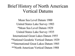
  • 1. Brief History of North American Vertical Datums Mean Sea Level Datum 1900 United States Lake Survey 1903 *Mean Sea Level Datum 1929 United States Lake Survey 1935 International Great Lakes Datum 1955 *National Geodetic Vertical Datum 1929 **International Great Lakes Datum 1985 **North American Vertical Datum 1988
  • 2. Early vertical datums were established for charting & hydrographic surveys of harbors along the eastern seaboard of the U.S.
  • 3.
  • 4.
  • 5. Adjustments to North American vertical datum based on increased tidal observations Year of Adjustment Kilometers of Leveling Number of Tide Stations 1900 1903 1907 1912 1929 21,095 31,789 38,359 46,468           75,159 (U.S.)               31,565 (Canada) 5 8 8 9         21 (U.S.)               5 (Canada)
  • 6.
  • 8. Tide Gauge Recorder – circa 1925
  • 9. Typical Modern Tide Gauge Station Diagram
  • 10. Tide Gauge – Anchorage, Alaska - 1913
  • 11.
  • 12. Basic Tide Phases & Cycles
  • 13.
  • 14.
  • 15. Mixed Tide at Pass Cavallo – May 23 rd to 24 th , 2005
  • 16. Mean Sea Level Trend – Galveston Gauge 8771450 - Galveston Pier 21 mean sea level trend is ~ + 6.5 mm – per year ( 2.13 feet per century) Mean Sea Level Data from 1908 to 1999
  • 17. Change in Global Mean Sea Level
  • 18.
  • 19.
  • 20.
  • 21.
  • 22. NGVD-29 to NAVD-88 Differences
  • 23. NGVD-29 to NAVD-88 Height Differences units in centimeters
  • 24. KP0037 DESIGNATION - A 42 KP0037 PID - KP0037 KP0037 STATE/COUNTY- NV/WHITE PINE KP0037 USGS QUAD - HOGUM (1987) KP0037 KP0037 *CURRENT SURVEY CONTROL KP0037 ___________________________________________________________________ KP0037* NAD 83(1986)- 39 04 07. (N) 114 27 07. (W) SCALED KP0037* NAVD 88 - 1747.784 (meters) 5734.19 (feet) ADJUSTED KP0037 ___________________________________________________________________ KP0037 GEOID HEIGHT- -20.69 (meters) GEOID03 KP0037 DYNAMIC HT - 1745.927 (meters) 5728.10 (feet) COMP KP0037 MODELED GRAV- 979,504.0 (mgal) NAVD 88 KP0037 KP0037 VERT ORDER - FIRST CLASS II KP0037.The orthometric height was determined by differential leveling KP0037.and adjusted by the National Geodetic Survey in June 1991. KP0037 KP0037.The geoid height was determined by GEOID03. KP0037 KP0037.The modeled gravity was interpolated from observed gravity values. KP0037 SUPERSEDED SURVEY CONTROL KP0037 NGVD 29 (??/??/92) 1746.576 (m) 5730.22 (f) ADJ UNCH 1 2 KP0037 KP0037.Superseded values are not recommended for survey control.
  • 25. Gravitational Effects on Leveling – Distortions in the NGVD-29 network Leveled Height Differences B A C Topography
  • 26. Transferring the elevation from a tide gauge to nearby benchmarks – Alaska - 1915
  • 27. Leveling crew - Navajo Springs, Arizona - 1921
  • 28. Benchmark crew - Utah, 1934
  • 29. Leveling crew - rural Mississippi - 1935
  • 30. Leveling crew – Whisky Pass, Colorado - 1931
  • 31. Leveling crew – Salmon River, Idaho - 1945
  • 32. Extending the Network – NGVD- 29 – Vertical control in the United States as of 1936
  • 33.
  • 34.