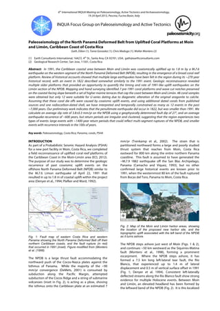
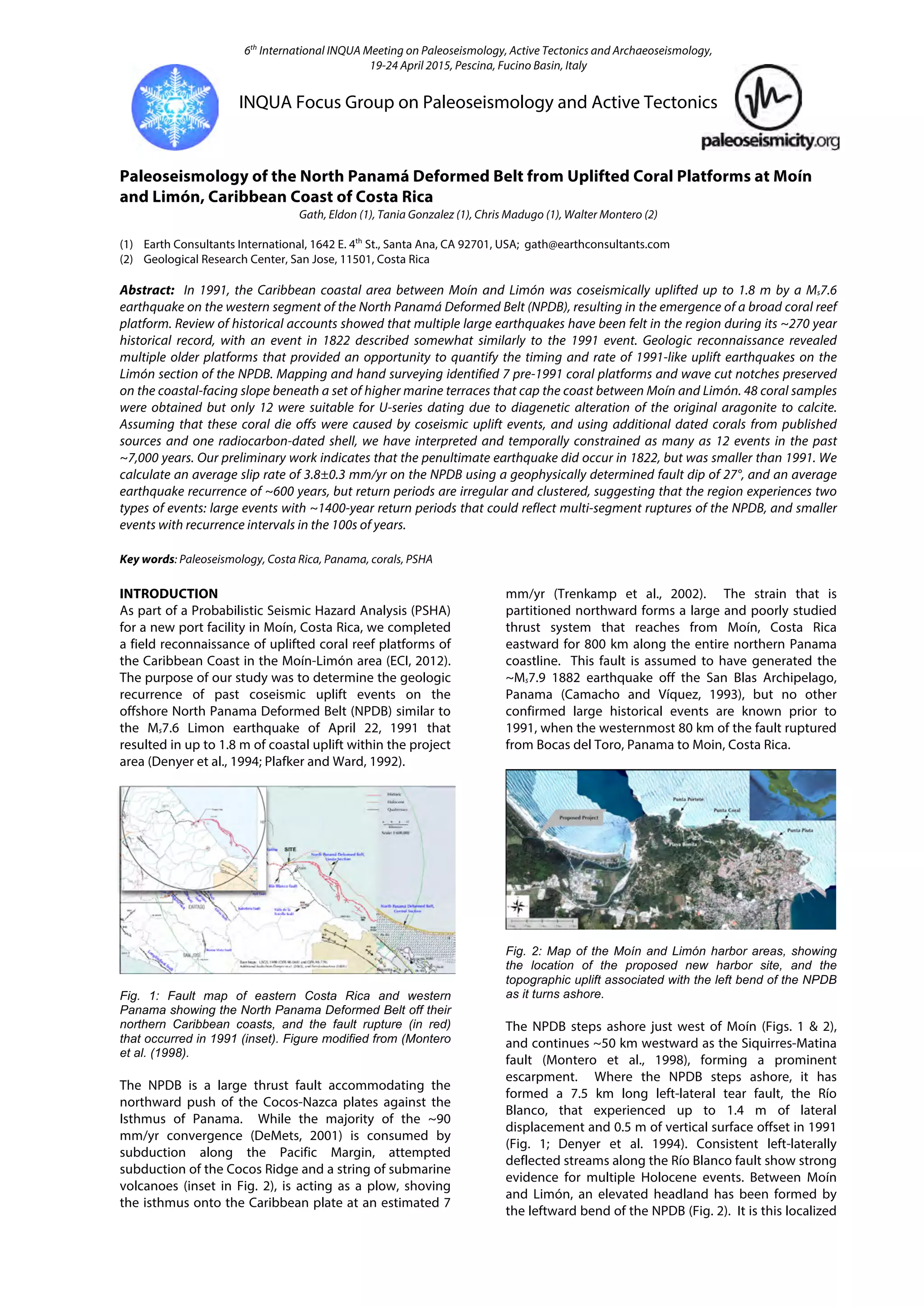
This document summarizes a study of uplifted coral reef platforms along the Caribbean coast of Costa Rica that provide evidence of past earthquakes on the North Panama Deformed Belt (NPDB). The study identified 7 pre-1991 coral platforms and dated 12 earthquake events over the past 7,000 years. Earthquake recurrence is irregular, with larger events every 1,400 years and smaller events every 200 years. The study estimated an average uplift rate along the NPDB of 1.9 mm/yr and a fault slip rate of 3.8 mm/yr based on dating and mapping of the coral platforms.
An Integrated Approach to the Exploration of Fractured Reservoirs: A Challeng...Mario Prince
This is an integrated analysis of the La Luna Formation in the Chuira pop-up structure, located in the Middle Magdalena Basin (MMVB). A structural trap originally mapped with 2D seismic and later with a 3D seismic volume, was interpreted using a conventional time structure maps and depth conversion methods. In 2009, the first well drilled a sequence of calcareous rocks which produce oil in stable natural flow but with a low rate. In order to understand this potential discovery, multidisciplinary studies were conducted including a detailed geology of the La Luna Formation information from outcrops, the integration of seismic attributes, log analysis, and an exhaustive reservoir research from existing samples.
Acordionero Oil Field Discovery, Middle Magdalena Basin, Colombia: An Unusual...Mario Prince
Oil exploration of Cenozoic clastic reservoirs in northern Middle Magdalena Basin has been predominantly focused on faulted anticline-type structural plays rather than more subtle stratigraphic or combination traps. The Acordionero field is a recent oil discovery found within an unusual structural -stratigraphic configuration, defined only after 3D and 2D seismic reprocessing benefitting from well results.
Based on a trap outline originally mapped with 2D seismic lines, the Acordionero-1 well was located and drilled in 2013 between two 1960s abandoned dry wells. The true trap configuration delineated by reprocessed seismic data was confirmed by follow-up 2014 drilling. In order to understand the field, multidisciplinary studies were conducted including detailed geology study of the Lisama Formation using outcrop and core data, reprocessing and interpretation of seismic data with constraining geological input, detailed log analysis and exhaustive reservoir examination from test and flow data.
The field is an important accumulation in the Paleocene sandstones of the Lisama Formation and has estimated original oil in place of more than 300 million barrels. Remarkably, the oil gravity for the field ranges from 13.5 to 25º API. The production rates are also atypical for the basin; the initial test for the well Acordionero 1 produced over 3200 BOPD in natural flow. This case history perfectly illustrates the concept of holistic approach to petroleum exploration that includes geology, geophysics and engineering contributions in all phases of the project (Enachescu, 2015). This integrated process is extended to field reservoir evaluation and design of production rate and optimum recovery plan.
In the past decade, particularly since the last summary of the
subject (Calvet, 2004), the Quaternary glaciation of the Pyrenees
has been the focus of new research. Unequal progress
has been achieved on three aspects: mapping the extent of
the Pyrenean ice field, quantifying the geomorphological
impact of glaciation on the preglacial landscape and refining
the chronology of the glacial fluctuations.
-Examined features ranging from valley systems in Margaritifer Sinus to inverted topography in Aeolis/Zephyria Plana
-Studied and analyzed MOLA, THEMIS-VIS, OMEGA, MOC, CRISM, HRSC, and CTX imagery
Strategic Intervention Materials (SIM) (Plate Boundary Convergence) for Grade 10 Earth Science Students of Don Marcelo C. Marty High School, Brgy. Poblacion North, Sta. Cruz, Zambales. S.Y. 2018-2019
The Ecuadorian shoreline is considered highly susceptible by impacts of tsunamis triggered by marine quakes or submarine landslides occurring close or nearby the subduction zone between the Nazca, Caribbean and South American plates. Since 1877 one dozen known tsunamis have been witnessed along this coast, mostly related to short-distanced seismic activities (earthquakes between Mw 6.9 to 8.8). However, no evidence of these impacts has been recorded in the sedimentary stratigraphy on the Ecuadorian platform so far. Nonetheless, in the southwestern
part of the Gulf of Guayaquil, due to a biological, chemical, stratigraphic and geochronologic study of a few cored samples an anomalous horizon to the other sedimentary layers has been identified and recognized as a paleo-tsunami deposit. This layer having a thickness of up to 10 cm and up to 1100 meters away from the actual shore, demonstrates various criteria which confirm its origin such as deep sea foraminifera like Pullenia bulloides, run-up and backwash features, fragments of molluscs, which are absent in other sedimentary levels, matrix of weathered chlorite potentially originated by glauconite besides other. Geocronologic evidence together with the calculated sedimentation rate, implies that a the tsunami surged the coastal lowlands around Villamil Playas about 1250 ± 50 yrs ago and must have been a major event originated from the western or northwestern direction.
Gigantic submarine landslides are among the most energetic events on the Earth surface. During the
Late Pleistocene the Mediterranean Sea was the scenario of a 9 number of such events, some of whose
geological fi ngerprints are the 500 km3 mass transport deposit SL2 at the Nile delta fan (dated at ca. 110
ka BP) and the Herodotus Basing Megaturbidite (HBM, a 400 km3 deposit dated at ca. 27.1 ka BP). This
paper presents an exploratory study on the tsunamigenic potential of these slides by using a numerical
model based on the 2D depth-averaged non-linear barotropic shallow water equations.
Gigantic submarine landslides are among the most energetic events on the Earth surface. During the
Late Pleistocene the Mediterranean Sea was the scenario of a 9 number of such events, some of whose
geological fi ngerprints are the 500 km3 mass transport deposit SL2 at the Nile delta fan (dated at ca. 110
ka BP) and the Herodotus Basing Megaturbidite (HBM, a 400 km3 deposit dated at ca. 27.1 ka BP).
Steps to Plate TectonicsStep 1 – Continental Driftwww.mat.docxdessiechisomjj4
Steps to Plate Tectonics:
Step 1 – Continental Drift
www.math.montana.edu / ~nmp / materials / ess / geosphere / inter / activities / plate_calc / pangaea_map.gif
The Continental Drift hypothesis published by Alfred Wegener in his 1915 book “ The Origin of Continents and Oceans”, although this was partially based on the work of earlier investigators.
Continental Drift = the continents were once connected in a single supercontinent called Pangaea. They have since drifted apart and are still moving today.
http://www.kidsgeo.com/geology-for-kids/0042-pangaea.php
Wegener’s hypothesis had several problems:
1) He had no power source – no way to make the continents move.
2) He thought the continents moved through the seafloor just like boats move through the ocean, but there was no evidence of this (no wake)
3) He was a meteorologist so many geologists didn’t take him seriously!
BUT Wegener had lots of evidence to show that the continents were once connected!
1) The jigsaw puzzle-like fit of the continents.
Figure 2.3 in text
Identical fossil assemblages on now widely spaced continents!
best about 250-200 MY ago
become increasingly dissimilar the closer to today we look!
Garrison, 2012, Essentials of Oceanography
3) Sequences of similar rock types on continents which do not now have the same geologic environment!
http://www.geology.ohio-state.edu/~vonfrese/gs100/lect25/index.html
4) Geologic structures (mountain ranges, faults, chains of volcanoes) which match up on either side of oceans but can not be found underwater.
5) Apparent polar wander – paleoclimatic evidence the continents had very different climates 250 MY ago than they do today.
either the continents moved or
the climate bands moved – which means the Earth’s poles of rotation moved.
Earth’s climate zones today are arranged symmetrically around the poles.
http://www.webquest.hawaii.edu/kahihi/sciencedictionary/C/climatezone.php
Paleoclimatic data from ˶300 MY ago, figure 2.5 in text
After Wegener died, his ideas were largely dismissed, until…
Post-Wegener evidence for drifting continents (and plate tectonics)…
6) Apparent Polar Wander – Paleomagnetic evidence.
Figure 2.7 showing that the Earth has a magnetic field very similar to that created by a bar magnet.
Directions of magnets parallel to Earth’s magnetic field lines.
Post-Wegener evidence for drifting continents (and plate tectonics)…
Figure 2.7b showing how magnets align to the Earth’s magnetic field when allowed to move freely.
Rocks containing the mineral magnetite (especially basalt) record the orientation of the Earth’s magnetic field at the time the rocks formed.
Figure 2.8a showing apparent polar wander paths for Europe and North America.
Figure 2.8b showing alignment of polar wander curves if the Atlantic Ocean is “closed”
The polar wander tracks for all the continents show great variation, suggesting it is the continents that moved!
If we put the continents “back to.
Shear wave velocity and Geology Based Seismic Microzonation of Port-au-Prince...Johana Sharmin
This is a presentation entirely based on the paper published by Brady R. Cox and his team. I just focused on the key points of the paper in the presentation.
Sea Level Changes as recorded in nature itselfIJERA Editor
The science of sea level changes is quite multi-facetted. The level of the oceans is always changing, both vertically and horizontally. We have documented these changes quite carefully. After the last glaciation maximum, sea level has risen in the order of 120 m. This rise has been oscillatory. We can set frames on the maximum rate of a sea level rise; at the most rapid ice-melting after the Last Ice Age, sea level rose at about 10 ±1 mm/yr. The thermal expansion of water is, of course, a function of the water column heated; hence the effect is zero at the shore where there is no water to expand. The claim by the IPCC on a present sea level rise is greatly exaggerated. Coastal tide gauges give relative rates in the order of 0-2 mm/yr. The value of the absolute rise in sea level varies between 0.0 and 1.1 mm/yr. There are firm reasons to downgrade, even neglect, the fear of a disastrous coastal flooding in the present century.
Were Most of Earth's Fossil-Bering Sedimentary Rock Layers Deposited by Noah'...Tim Helble
This presentation uses the Coconino Sandstone to evaluate the question of whether it is quantitatively reasonable for sedimentary formations to have been deposited by Noah's Flood.
that is associated with broad upwarping of the overlying litho.docxmattinsonjanel
that is associated with broad upwarping of the overlying lithosphere (figure 5.1 iA). As a result, the lithosphere is stretched, causing the brittle crustal rocks to break into large slabs. As the tectonic forces continue to pull the crust apart, these crustal fragments sink, generating an elongated depression called a continental rift (figure 5.1 ib).
A modern example of an active continental rift is the East African Rift (figure s. i 2). Whether this rift will eventually result in the breakup of Africa is a topic of continued research. Nevertheless, the East African Rift is an excellent model of the initial stage in the breakup of a continent. Here, tensional forces have stretched and thinned the crust, allowing molten rock to ascend from the mantle. Evidence for recent volcanic activity includes several large volcanic mountains including Mount Kilimanjaro and Mount Kenya, the tallest peaks in Africa. Research suggests that if rifting continues, the rift valley will lengthen and deepen, eventually extending out to the margin of the landmass (r;<;ur.E 5.1 ic). At this point, the rift will become a narrow sea with an outlet to the ocean. The Red Sea, which formed when the Arabian Peninsula split from Africa, is a modern example of such a feature. Consequently, the Red Sea provides us with a view of how the Atlantic Ocean may have looked in its infancy (figure 5.1 id).
QEOD^
Forces Within sSWHBe Plate Tectonics
New lithosphere is constantly being produced at the oceanic ridges; however, our planet is not growing larger—its total surface area remains constant. A balance is maintained because older, denser portions of oceanic lithosphere descend into the mantle at a rate equal to seafloor production. This activity occurs along convergent (con = together, vergere = to move) boundaries, where two plates move toward each other and the leading edge of one is bent downward, as it slides beneath the other.
Convergent boundaries are also called subduction zones, because they are sites where lithosphere is descending (being subducted) into the mantle. Subduction occurs because the density of the descending tectonic plate is greater than the density of the underlying asthenosphere. In general, oceanic lithosphere is more dense than the asthenosphere, whereas continental lithosphere is
(
Upwarping
figure 5.11
Continental rifting and the formation of a new ocean basin.
A.
The initial stage of con tinental rifting tends to include upwelling in the mantle that is associated with broad doming of the lith-osphere.Tensional forces and buoyant uplifting of the heated lithosphere cause the crust to be broken into large slabs.
b.
A
s the crust is pulled apart, large slabs of rock sink, generating a rift valley.
C.
Further spreading generates a narrow sea, similar to the present-day Red Sea.
D.
Eventually, an expansive ocean basin and ridge system are created.
)less dense and resists subduction. As a consequence, only oceanic lithosphere will subd ...
A sequence of slides detailing a preliminary study for age dating (biostrat) the Enjefa Beach succession in Kuwait. The sedimentology of the cliff section is that of Dr Saifullah Khan Tanoli and acts as the framework. The description of the modern day Beach Rock is by S Crittenden
1. 6th
International INQUA Meeting on Paleoseismology, Active Tectonics and Archaeoseismology,
19-24 April 2015, Pescina, Fucino Basin, Italy
INQUA Focus Group on Paleoseismology and Active Tectonics
Paleoseismology of the North Panamá Deformed Belt from Uplifted Coral Platforms at Moín
and Limón, Caribbean Coast of Costa Rica
Gath, Eldon (1), Tania Gonzalez (1), Chris Madugo (1), Walter Montero (2)
(1) Earth Consultants International, 1642 E. 4th
St., Santa Ana, CA 92701, USA; gath@earthconsultants.com
(2) Geological Research Center, San Jose, 11501, Costa Rica
Abstract: In 1991, the Caribbean coastal area between Moín and Limón was coseismically uplifted up to 1.8 m by a Ms7.6
earthquake on the western segment of the North Panamá Deformed Belt (NPDB), resulting in the emergence of a broad coral reef
platform. Review of historical accounts showed that multiple large earthquakes have been felt in the region during its ~270 year
historical record, with an event in 1822 described somewhat similarly to the 1991 event. Geologic reconnaissance revealed
multiple older platforms that provided an opportunity to quantify the timing and rate of 1991-like uplift earthquakes on the
Limón section of the NPDB. Mapping and hand surveying identified 7 pre-1991 coral platforms and wave cut notches preserved
on the coastal-facing slope beneath a set of higher marine terraces that cap the coast between Moín and Limón. 48 coral samples
were obtained but only 12 were suitable for U-series dating due to diagenetic alteration of the original aragonite to calcite.
Assuming that these coral die offs were caused by coseismic uplift events, and using additional dated corals from published
sources and one radiocarbon-dated shell, we have interpreted and temporally constrained as many as 12 events in the past
~7,000 years. Our preliminary work indicates that the penultimate earthquake did occur in 1822, but was smaller than 1991. We
calculate an average slip rate of 3.8±0.3 mm/yr on the NPDB using a geophysically determined fault dip of 27°, and an average
earthquake recurrence of ~600 years, but return periods are irregular and clustered, suggesting that the region experiences two
types of events: large events with ~1400-year return periods that could reflect multi-segment ruptures of the NPDB, and smaller
events with recurrence intervals in the 100s of years.
Key words: Paleoseismology, Costa Rica, Panama, corals, PSHA
INTRODUCTION
As part of a Probabilistic Seismic Hazard Analysis (PSHA)
for a new port facility in Moín, Costa Rica, we completed
a field reconnaissance of uplifted coral reef platforms of
the Caribbean Coast in the Moín-Limón area (ECI, 2012).
The purpose of our study was to determine the geologic
recurrence of past coseismic uplift events on the
offshore North Panama Deformed Belt (NPDB) similar to
the Ms7.6 Limon earthquake of April 22, 1991 that
resulted in up to 1.8 m of coastal uplift within the project
area (Denyer et al., 1994; Plafker and Ward, 1992).
Fig. 1: Fault map of eastern Costa Rica and western
Panama showing the North Panama Deformed Belt off their
northern Caribbean coasts, and the fault rupture (in red)
that occurred in 1991 (inset). Figure modified from (Montero
et al. (1998).
The NPDB is a large thrust fault accommodating the
northward push of the Cocos-Nazca plates against the
Isthmus of Panama. While the majority of the ~90
mm/yr convergence (DeMets, 2001) is consumed by
subduction along the Pacific Margin, attempted
subduction of the Cocos Ridge and a string of submarine
volcanoes (inset in Fig. 2), is acting as a plow, shoving
the isthmus onto the Caribbean plate at an estimated 7
mm/yr (Trenkamp et al., 2002). The strain that is
partitioned northward forms a large and poorly studied
thrust system that reaches from Moín, Costa Rica
eastward for 800 km along the entire northern Panama
coastline. This fault is assumed to have generated the
~Ms7.9 1882 earthquake off the San Blas Archipelago,
Panama (Camacho and Víquez, 1993), but no other
confirmed large historical events are known prior to
1991, when the westernmost 80 km of the fault ruptured
from Bocas del Toro, Panama to Moin, Costa Rica.
Fig. 2: Map of the Moín and Limón harbor areas, showing
the location of the proposed new harbor site, and the
topographic uplift associated with the left bend of the NPDB
as it turns ashore.
The NPDB steps ashore just west of Moín (Figs. 1 & 2),
and continues ~50 km westward as the Siquirres-Matina
fault (Montero et al., 1998), forming a prominent
escarpment. Where the NPDB steps ashore, it has
formed a 7.5 km long left-lateral tear fault, the Río
Blanco, that experienced up to 1.4 m of lateral
displacement and 0.5 m of vertical surface offset in 1991
(Fig. 1; Denyer et al. 1994). Consistent left-laterally
deflected streams along the Río Blanco fault show strong
evidence for multiple Holocene events. Between Moín
and Limón, an elevated headland has been formed by
the leftward bend of the NPDB (Fig. 2). It is this localized
3. 6th
International INQUA Meeting on Paleoseismology, Active Tectonics and Archaeoseismology,
19-24 April 2015, Pescina, Fucino Basin, Italy
INQUA Focus Group on Paleoseismology and Active Tectonics
In addition to the corals, we also collected two shells,
one from its growth position at the base of a bench.
These corals were dated using 14C.
Fig. 7: One of the corals uplifted by the 1991 earthquake.
Fig. 8: Sampling drill used for the older coral platforms.
RESULTS
Despite the difficulties with the U-Th dating of the corals,
the study did generate important results concerning the
paleoseismic history of the NPDB that were useful to the
PSHA for the project. Before those results could be
understood however, the coral ages needed to be put
into context of their vertical positioning with respect to
the many mapped platforms (Fig. 9). Not all paleo-
events might be preserved everywhere along the coast
due to dissolution or erosional removal.
In Fig. 9 we correlate the various sea level indicators and
platforms that we mapped at the three principal study
locations (vertical transects) from west to east along the
coast. Within the error limits of our mapping results,
there are definite correlations of platform elevations
across the 5 km coastline. But there are also platforms
that are recognizable at only one or two locations.
Additional mapping along the coastline between the
three principal locations should result in better
resolution of the platform correlations.
Fig. 9: Composite plot of the coral platform (brown) and
notch (light blue) elevations that were mapped at three
principal localities, west to east (left to right) along the
Limón coast. Elevation in meters on the left; horizontal
distance is about 5 km. The line widths represent the
uncertainties in the elevation measurements.
After correlating the coral samples across the various
platforms, we needed to correct their current elevations
with the sea level elevation that was present at their
determined age (Fig. 10). The 6.2 ka coral sample was
obtained from the fourth highest platform on Punta
Portete (Fig. 9) at a modern elevation +2.9 m. Absent
better information on coral water depth ranges, we
assumed an original water depth of 2 m for all stony
coral samples and 0.5 m for others. As illustrated on Fig.
9, at 6.2 kya the sea level was at -6 m, resulting in an
uplift of 10.9 m (2.9+2+6) in 6.2 ka (uplift rate = 1.8
mm/yr). Similar results were calculated for all of the
other datable samples and they were placed into
context on Fig. 11 to show their true positioning with
both age and lateral correlation.
Fig. 10: Composite plot of the various Caribbean sea level
results developed by six different researchers. The black
line from Hubbard et al. (2005) represents an approximate
mean value that we used in our analysis to correct for paleo
sea level elevation. The yellow bars illustrate that the 6.2
ka coral sample corresponds to a -6 m sea level.
4. 6th
International INQUA Meeting on Paleoseismology, Active Tectonics and Archaeoseismology,
19-24 April 2015, Pescina, Fucino Basin, Italy
INQUA Focus Group on Paleoseismology and Active Tectonics
Fig. 11 shows how the various events were counted
across the study area, and how often they correlate to
other dated locations laterally, west to east. Unless we
are missing events, which is possible, the pattern of
earthquakes strongly indicates that they are irregular,
with several events clustered between longer quiescent
intervals.
Fig. 11: A twelve event earthquake chronology that was
determined after correcting and correlating the dated coral
sample elevations for the 7.5 m sea level rise in the last 7
ka, as measured from Fig. 10. The interpreted event
number is circled, starting with 1991 and 1882 AD near the
bottom. Age in years on the left, distance west to east (left
to right) across the bottom (Fig. 9), but not to scale.
Our limited data set allows only speculation about event
magnitude, but the two most recent events (1822 and
1991) resulted in ~1 m and 1.8 m uplift events
respectively, clearly implying that they were of different
magnitudes. From Fig. 11, before the 1822-1991 cluster,
it was almost 1500 years to the pre-penultimate event
(#3), and another 1500 years to the one before that (#4),
closely preceded by an event (#5). Then it was over 1000
years before a series of temporally clustered events (#6-
11) followed by an 800 year hiatus to event #12.
With 12 events recognized in 7 ka, the average
recurrence interval would be ~600 years. But based on
events 2, 5 & 7, we conclude that the recurrence
between uplift events can be as short as ~200 years,
while the recurrence between larger events can be as
long as 1400 years. These rates are in good agreement
with those determined by Plafker and Ward (1992) but
provide a much higher degree of resolution to be able to
interpret the temporal variability.
To calculate the uplift rate we calculated each dated
sample’s uplift rate (1.6–2.7 mm/yr, strongly clustered
between 1.6 and 2.1 mm/yr, and averaged them. To
calculate the fault’s slip rate, we used the geophysically-
imaged 27° of the offshore fault (Brandes et al., 2008)
and resolved the rate trigonometrically from the uplift
rate, resulting in 3.8±0.3 mm/yr, or about 50% of the
Trenkamp et al. (2002) rate for Caribbean convergence.
CONCLUSIONS
• 75% of the coral samples were too degraded to
date (aragonite to calcite transformation).
• Those samples dated ranged from 1991 to ~7,000
years BP.
• Interpreted 12 events on the NPDB, assuming the
coral deaths were all earthquake-induced.
• Holocene uplift rate of 1.9 ± 0.2 mm/yr.
• Slip rate on NPDB of 3.8 ± 0.3 mm/yr.
• Irregular earthquake recurrence with larger events
~1400 years and smaller events ~200+ years.
• Most recent event was April 22, 1991 (Ms7.6).
• Penultimate event was in 1822, while the pre-
penultimate event was 1.6 ka.
• There is a huge opportunity for more work.
Acknowledgements: This project was done under contract to
CH2M Hill and we appreciate their permission to present this
work. Warren Sharp of the Berkeley Chronology Center
processed our coral samples for U-Th dates. Our paleoseismic
results were incorporated into the project’s PSHA, and while
those results are not included in this short paper, we also thank
Dario Rosidi, Nason McCullough, and Ken Campbell for their
contributions.
REFERENCES
Ambraseys, N.N., and Adams, R.D., 2001, The Seismicity of
Central America: A Descriptive Catalogue 1898-1995:
Imperial College Press, London, 309 p.
Boschini, I. and Montero, W., 1994, Sismicidad histórica e
instrumental, Volumen Especial Terremoto de Limón 22 de
abril de 1991; Revista Geológica América Central, pp. 65-82.
Brandes, C., Astorga, A., Littke, R., and Winsermann, J., 2008,
Basin modelling of the Limón Back-arc Basin (Costa Rica):
burial history and temperature evolution of an island arc-
related basin-system; Basin Research, v. 20, pp. 119–142.
Camacho, E., and Víquez, V., 1993, Historical seismicity of the
North Panama Deformed Belt; Revista Geológica de América
Central, Vol. 15, pp. 49-64.
Denyer, P., Arias, O., and Personius, S., 1994, Efecto tectónico del
terremoto de Limón; Revista Geológica de América Central,
Volumen Especial del Terremoto de Limón, pp. 39-52.
Earth Consultants International, 2012, Seismic Hazard
Assessment for a Proposed Harbor Facility in Moín, Costa
Rica; unpublished consulting report to CH2M Hill, Feb. 21,
2012, ECI PN 3312, 68 p.
Hubbard, D.K., Zankl, H., van Heerden, I. and Gill, I.P., 2005,
Holocene reef development along the northeastern St.
Croix shelf, U.S. Virgin Islands; Journal of Sedimentological
Research, Vol. 75, pp. 97-113.
Montero, W., Denyer, P., Barquero, R., Alvarado, G. E., Cowan, H.,
Machette, M. N., Haller, K. M. and Dart, R. L., 1998, Map and
Database of Quaternary Faults and Folds in Costa Rica and
its Offshore Regions, USGS Open-File Report 98-481, 63 p.,
map scale 1: 500,000.
Plafker, G., and Ward, S.N., 1992, Backarc thrust faulting and
tectonic uplift along the Caribbean sea coast during the
April 22, 1991 Costa Rica earthquake; Tectonics, Vol. 11, No.
4, pp. 709-718.
Trenkamp, R., Kellogg, J.N., Freymueller, J.T., and Mora, H.P.,
2002, Wide plate margin deformation, southern Central
America and northwestern South America, CASA GPS
observations; Journal of South American Earth Sciences, Vol.
15, pp. 157-171.