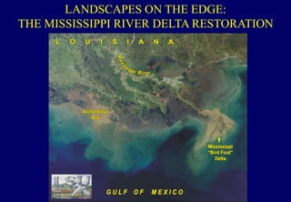
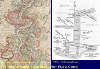
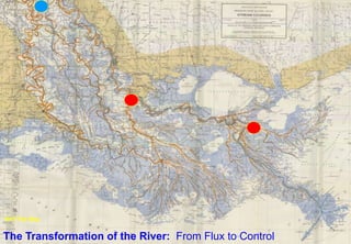
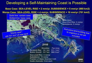
LANDSCAPES ON THE EDGE:
THE MISSISSIPPI RIVER DELTA RESTORATION
Trees Aged at 250 yrs
Disturbance
Reorganization
Displaced
700,000
Homes destroyed
130,000
Dead
246
The Great
Flood 1927
John Stewart Curry
Hoover and the Flood
1940
Library of Congress
1947 Fisk Map of the river’s historic course 1958 River Flood Capacity Diagram
The Transformation of the River: From Flux to Control
MR&T
Flood Control
Act of 1928
The Transformation of the River: From Flux to Control
1947 Fisk Map
Historical Basins of the Mississippi River
5. Major Disturbance to social systems; included floods and hurricane
events; flooding that threaten public safety and economic development
– Federal Responsibility and Response
Built Infrastructure
Annual report of Paul Octave Hebert, State
Engineer to the Louisiana Legislature, Jan. 1847
Civil engineers Paul Octave Hebert and Absalom D.
Woodridge supported a diversified approach to flood
control that depended on the combination of outlets and
levees. They criticized current measures that relied
solely on levees to prevent overflow.
By urging the state to adopt new policies aimed at
keeping open the last few remaining outlets and building
artificial ones to replace those already lost, state
engineers tried to temper the drive of many planters to
remake the river.
13
1: The Atchafalaya Floodway represents
major section of flood control system
Roberts et al. 19971912 1930 1960 1975
1: The Atchafalaya Floodway represents
major success in delta formation
THE WAX LAKE DELTA AS ANALOGUE OF HOW TO REBUILD A DELTA
1990
2005
Wonsuck Kim, Gary Parker, David
Mohrig, Robert Twilley, EOS 2009
MIGRATION OF THE MODEL FROM WAX LAKE TO THE
MISSISSIPPI RIVER BELOW NEW ORLEANS:
Two diversions: Barataria Bay and Breton Sound (for demonstration purposes)
Worse Case: SEA-LEVEL RISE = 4 mm/yr, SUBSIDENCE = 10 mm/yr (701 km2)
Solid line: variant case
Dotted line: base case
Developing a Self-Maintaining Coast is Possible
Base Case: SEA-LEVEL RISE = 2 mm/yr, SUBSIDENCE = 5 mm/yr (980 km2)
SEA
LEVEL
Tidal/River
Flooding
Nutrient
Input
PRIMARY PRODUCTION
Increase Sea Level
SUBSIDENCE
Managing River and
Coastal Processes
linked with
Engineering Design
to Develop a Self-
Maintaining Delta
Landscape
(footprint)
Sand - Silt – Salt - Nitrate
Tradeoffs of Rebuilding Deltaic Coasts
Salinity
LAND
Nutrients
Catchment to the
Coast: Hubbard Brook
Type Coastal
Ecosystem Studies
SCIENCE, 27 August 2005
Katrina 2005
23
Healthy very tall wetlands being cut for the access channel
of the MRGO (Mississippi River Gulf Outlet)
EXTENSIVE CYPRESS SWAMPS
EXTENSIVE AREAS OF REED SWAMPS
5-6 M HIGH
5. Major Disturbance to social systems; included floods and hurricane
events; flooding that threaten public safety and economic development
– Federal Responsibility and Response
Built Infrastructure
1. Regional coastal ‘hubbard brooks’
– case studies of regional trends as
research, education, and outreach
opportunities.Goal: Widespread use of ecosystem-based
approaches to managing land, water and living
resources in coastal areas.
Goal: Restored function and productivity of
degraded ecosystems.
Goal: Sound scientific information to support
ecosystem-based approaches to managing the
coastal environment.
Healthy Coastal Ecosystems
3. Catchment to the Coast: Have to
leverage with other professional units
within university land grant system –
and beyond !
2. Calibrate Cause and Effect:
Synthesis of long term trends at
ecosystem level –build confidence in
how we restore coastal ecosystems
(diagnostics vs prescription).
4. Plan for the Reorganization Phase:
Be prepared with variety of coastal
hazards to provide clear, sound, and
balanced ecosystem perspectives.
Coastal Sustainability Studio
LSU
Sponsored by the America Wetlands Foundation
with support from Chevron Corporation
Goals
Building with Nature - self sustaining ecosystems
Intelligent storm and flood protection
Productive innovative economy
Dynamic and sustainable community
Bayou Bienvenue
Baton Rouge
New Orleans
Atchafalaya
River Basin
Lake Charles
Lafayette
Houma
Old River Control
Gulf of Mexico
Managing the Mississippi: Flood Control that Compliments Restoration
Baton Rouge
New Orleans
Atchafalaya
River Basin
Lake Charles
Lafayette
Houma
Old River Control
Gulf of Mexico
Managing the Mississippi: From Flood Control to Controlled Flood
Baton Rouge
New Orleans
Atchafalaya
River Basin
Lake Charles
Lafayette
Houma
Old River Control
Gulf of Mexico
Wax Lake
Diversion
Terrebonne
Diversion
Bayou LaFourche
Diversion
Davis Pond
Diversion
MRGO/LaLoutre
Diversion
Building on the Urban Edge: Lower 9th Ward Wetland Center
Building on the Urban Edge: Lower 9th Ward, New Orleans
Design Process Stage 4: Scenarios
Industry and Jobs Wetland regenerationRecreationHousing and
Neighborhoods
The Productive
Landscape
Scenario 1
Scenario 2
Scenario 3
The Transformation of the River: The Future
Healthy Coastal Ecosystems

Healthy Coastal Ecosystems

  • 1.
    LANDSCAPES ON THEEDGE: THE MISSISSIPPI RIVER DELTA RESTORATION
  • 2.
    Trees Aged at250 yrs Disturbance Reorganization
  • 3.
    Displaced 700,000 Homes destroyed 130,000 Dead 246 The Great Flood1927 John Stewart Curry Hoover and the Flood 1940 Library of Congress
  • 4.
    1947 Fisk Mapof the river’s historic course 1958 River Flood Capacity Diagram The Transformation of the River: From Flux to Control
  • 5.
  • 6.
    The Transformation ofthe River: From Flux to Control 1947 Fisk Map
  • 9.
    Historical Basins ofthe Mississippi River
  • 11.
    5. Major Disturbanceto social systems; included floods and hurricane events; flooding that threaten public safety and economic development – Federal Responsibility and Response Built Infrastructure
  • 12.
    Annual report ofPaul Octave Hebert, State Engineer to the Louisiana Legislature, Jan. 1847 Civil engineers Paul Octave Hebert and Absalom D. Woodridge supported a diversified approach to flood control that depended on the combination of outlets and levees. They criticized current measures that relied solely on levees to prevent overflow. By urging the state to adopt new policies aimed at keeping open the last few remaining outlets and building artificial ones to replace those already lost, state engineers tried to temper the drive of many planters to remake the river.
  • 13.
    13 1: The AtchafalayaFloodway represents major section of flood control system Roberts et al. 19971912 1930 1960 1975
  • 14.
    1: The AtchafalayaFloodway represents major success in delta formation
  • 15.
    THE WAX LAKEDELTA AS ANALOGUE OF HOW TO REBUILD A DELTA 1990 2005 Wonsuck Kim, Gary Parker, David Mohrig, Robert Twilley, EOS 2009
  • 16.
    MIGRATION OF THEMODEL FROM WAX LAKE TO THE MISSISSIPPI RIVER BELOW NEW ORLEANS: Two diversions: Barataria Bay and Breton Sound (for demonstration purposes)
  • 17.
    Worse Case: SEA-LEVELRISE = 4 mm/yr, SUBSIDENCE = 10 mm/yr (701 km2) Solid line: variant case Dotted line: base case Developing a Self-Maintaining Coast is Possible Base Case: SEA-LEVEL RISE = 2 mm/yr, SUBSIDENCE = 5 mm/yr (980 km2)
  • 18.
  • 19.
    Managing River and CoastalProcesses linked with Engineering Design to Develop a Self- Maintaining Delta Landscape (footprint)
  • 20.
    Sand - Silt– Salt - Nitrate Tradeoffs of Rebuilding Deltaic Coasts Salinity LAND Nutrients
  • 21.
    Catchment to the Coast:Hubbard Brook Type Coastal Ecosystem Studies
  • 22.
    SCIENCE, 27 August2005 Katrina 2005
  • 23.
    23 Healthy very tallwetlands being cut for the access channel of the MRGO (Mississippi River Gulf Outlet) EXTENSIVE CYPRESS SWAMPS EXTENSIVE AREAS OF REED SWAMPS 5-6 M HIGH
  • 26.
    5. Major Disturbanceto social systems; included floods and hurricane events; flooding that threaten public safety and economic development – Federal Responsibility and Response Built Infrastructure
  • 28.
    1. Regional coastal‘hubbard brooks’ – case studies of regional trends as research, education, and outreach opportunities.Goal: Widespread use of ecosystem-based approaches to managing land, water and living resources in coastal areas. Goal: Restored function and productivity of degraded ecosystems. Goal: Sound scientific information to support ecosystem-based approaches to managing the coastal environment. Healthy Coastal Ecosystems 3. Catchment to the Coast: Have to leverage with other professional units within university land grant system – and beyond ! 2. Calibrate Cause and Effect: Synthesis of long term trends at ecosystem level –build confidence in how we restore coastal ecosystems (diagnostics vs prescription). 4. Plan for the Reorganization Phase: Be prepared with variety of coastal hazards to provide clear, sound, and balanced ecosystem perspectives.
  • 29.
    Coastal Sustainability Studio LSU Sponsoredby the America Wetlands Foundation with support from Chevron Corporation
  • 30.
    Goals Building with Nature- self sustaining ecosystems Intelligent storm and flood protection Productive innovative economy Dynamic and sustainable community Bayou Bienvenue
  • 31.
    Baton Rouge New Orleans Atchafalaya RiverBasin Lake Charles Lafayette Houma Old River Control Gulf of Mexico Managing the Mississippi: Flood Control that Compliments Restoration
  • 32.
    Baton Rouge New Orleans Atchafalaya RiverBasin Lake Charles Lafayette Houma Old River Control Gulf of Mexico
  • 33.
    Managing the Mississippi:From Flood Control to Controlled Flood Baton Rouge New Orleans Atchafalaya River Basin Lake Charles Lafayette Houma Old River Control Gulf of Mexico Wax Lake Diversion Terrebonne Diversion Bayou LaFourche Diversion Davis Pond Diversion MRGO/LaLoutre Diversion
  • 34.
    Building on theUrban Edge: Lower 9th Ward Wetland Center
  • 35.
    Building on theUrban Edge: Lower 9th Ward, New Orleans
  • 36.
    Design Process Stage4: Scenarios Industry and Jobs Wetland regenerationRecreationHousing and Neighborhoods The Productive Landscape Scenario 1 Scenario 2 Scenario 3
  • 37.
    The Transformation ofthe River: The Future

Editor's Notes

  • #2 The previous two subject areas are ‘new in themselves’. This one seems to be the most traditional: basins are the heart of sed/strat, landscapes the heart of geomorph. But...
  • #5 In 1874, after years of failed attempts at dredging, levee building and debate about constructing a canal, James Eads proposed building large Jetties along the outlet of the river.
  • #7 This map shows the various course of the river as it navigated the delta over thousands of years.
  • #8 But as impressive as the jetties were for the movement of goods in through the mouth of the river, even more dramatic was the change it encapsulated for the treatment of the River throughout the delta region. The 1879 creation of the Mississippi River Commission, with Eads as one of its most prominent members took on the huge roll of controlling and bending the entire purpose of the river.
  • #11 Thresholds of deltaic coast Ecosystem state change is the conversion of wetlands to open water – wetland loss – 44 km2 per year - Associate concepts related to thresholds of restoration; contrast to most of the talks on eutrophication
  • #12 It is as if two separate objectives are functioning but in sequence. The first maximizes production and accumulation The second maximizes invention and reassortment. The two objectives can not be maximized simultaneously but only occur sequentially. The adaptive cycle therefore embraces two opposites: growth and stability on the one hand and changes and variety on the other.
  • #15 Wax position to Atch Both emerged in 1973 Wax has more natural channel and island development Atch influenced by dredge spoil islands for navigation channel maintenance Per unit discharge, higher exposure of flow to wetland areas, more energetic
  • #19 Wetlands in deltaic coast must have capacity to adapt to rise is sea level; and along LA coast there is also change in water levels caused by land sinking Relative rise in sea level is the combined effect of sea level and subsidence – important threshold change in elevation and thus water levels Thus adaptation for wetlands is to maintain surface elevation equal to the annual change in relative sea level If not, then wetland drowns and converts to open water – condition of degradation
  • #20 The other adaptation is the supply of sediment that is linked to management of river – two effects One - There has been reduction of sediment delivery to the floodplains – restricted to flow out to GOM – see diagram Second – there is reduction of sediment from the river basin – see statistics Thus – sediment supply to provide capacity for wetlands to adapt has been reduced this reduces the capacity to reach critical thresholds of accretion or elevation to counter effects of relative sea level rise
  • #27 It is as if two separate objectives are functioning but in sequence. The first maximizes production and accumulation The second maximizes invention and reassortment. The two objectives can not be maximized simultaneously but only occur sequentially. The adaptive cycle therefore embraces two opposites: growth and stability on the one hand and changes and variety on the other.
  • #38 As essential to the construction of the delta as the river was, the river’s absence is rapidly leading to its disappearance.