Download to read offline
![Fabricating the Delta 2
WAX LAKE
DELTA [ ]Fabricating the Delta
LSU ARCH 4993](https://image.slidesharecdn.com/fabricatingthedeltaforweb-150707213101-lva1-app6892/85/Fabricating-the-delta-for-web-1-320.jpg)
![Fabricating the Delta 2
WAX LAKE
DELTA [ ]Fabricating the Delta
LSU ARCH 4993](https://image.slidesharecdn.com/fabricatingthedeltaforweb-150707213101-lva1-app6892/75/Fabricating-the-delta-for-web-1-2048.jpg)
![WAX LAKE
DELTA [ ]Fabricating the Delta
LSU ARCH 4993](https://image.slidesharecdn.com/fabricatingthedeltaforweb-150707213101-lva1-app6892/85/Fabricating-the-delta-for-web-2-320.jpg)

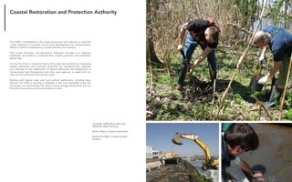
![Fabricating the Delta 14
The Hurricane Katrina disaster of August 2005 highlighted a problem
recognized for decades: the Mississippi River Delta (MRD) is sinking, resulting in
extensive loss of wetlands and increasing the exposure of urban and industrial
infrastructuretocoastalstorms[Fischetti2001;NRC2005].Byfarthelargestcontributing
factor to wetlands loss has been the construction of flood control levees along the
lower Mississippi River, that has cutting off the river from its surrounding delta plain,
thus converting the river into a pipeline that shunts water and sediment to the Gulf of
Mexico and starves the wetlands of sediment [Day et al. 2005]. The land-loss problem
will be exacerbated further with eustatic sea level rise [Blum & Roberts 2009], which
is a problem facing deltas and depositional coastlines the world over [Syvitski et al.
2009; Vörösmarty et al. 2009]. The urgent need for large- scale wetland restoration
through the diversion of Mississippi River water and sediments has been recognized
throughout the restoration community [Day et al. 2003; Mitsch & Day 2006; Mitsch
et al. 2005, CPRA 2007]. This management strategy uses diversion control structures
from the Mississippi River to deliver freshwater and sediments to declining wetland
areas (e.g., Barataria Bay and Breton Sound) [[Delaune et al. 2008; Day et al. 2005,
2007; Keddy et al. 2007; Lane et al. 2006]. These early diversions were not designed to
capture sediment from the river and cannot be expected to build significant land, but
they do restore seasonal freshwater pulses to the estuary. Large-scale river diversions
that can deliver coarse sediment are needed to build wetlands. This concept has been
modeled and projects 1,000 km2 of new wetlands can be built with the Mississippi
River within a century [Kim et al. 2009].
One of the major challenges facing large-scale delta restoration is confidence
that the trajectory of delta growth and decay of these new subdeltas will build land
and promote wetland ecology as predicted in mathematical and physical models. The
Wax Lake Delta (WLD) is living proof that land building in the face of sea level rise
and subsidence is possible, as long as a substantial sediment supply is available in a
shallow depositional region. Thus, the WLD is both an inspiring analog for engineered
diversions of the Mississippi River, and an ideal natural laboratory to understand
the ecogeomorphic evolution of growing delta lobes. Delta restoration requires
calibrated predictive models for design and scenario analysis that are grounded in
comprehensive field-based data sets. There is no facility anywhere in the world that can
provide such data sets. The DELTA LAB research observatory at WLD provides critical
data to the worldwide research community focusing on evolution and restoration of
prograding delta environments. The delta is developing in shallow bayhead near the
Far Left, Wax Lake Delta Vegetated
horizon
Left, Wax Lake Delta Marsh Vegetation
WAX LAKE DELTA](https://image.slidesharecdn.com/fabricatingthedeltaforweb-150707213101-lva1-app6892/85/Fabricating-the-delta-for-web-7-320.jpg)
![Fabricating the Delta 16
with lease agreement by the Louisiana Department of Wildlife and Fisheries.
The accuracy of land building models is completely dependent upon the breadth and
accuracy of the field data available development and verification. While more detailed
numerical models are currently being developed to investigate the physical controls
over fine scale channel structure [Edmonds & Slingerland 2010] the data sets need to
validate them are not currently available. The ecological, nutrient biogeochemical,
and storm surge reduction attributes of delta models are also still being developed
and are limited by a lack of large spatial and temporal data sets. These types of
models are critical to predicting the benefits that large-scale coastal and ecological
restoration projects can provide society and when developed will be an integral part
of the restoration management practice in Louisiana as well as other deltas around
the world. Deltas exemplify the strong coupling across disciplinary boundaries that we
recognize as characteristic of Earth-surface dynamics [Committee on Challenges and
Opportunities in Earth Surface Processes 2010]. We stress also that engineering is, in
effect, folded into the entire effort as the basic-science research increasingly strives to
produce engineering-style predictions of the outcomes of specific designs and actions.
Finally, the problem of predicting delta evolution and dynamics is as scientifically rich
as it is socially important. Given that hundreds of millions of people worldwide live or
depend on low-lying depositional coasts, human impacts dominate coastal dynamics
(e.g. by modifying channel patterns, building levees, and manipulating water flow);
social factors and social sciences need to be included in the entire framework for delta
management and restoration [Syvitski et al. 2009].
The missing centerpiece in the grand scientific challenge of delta prediction and
restoration is a densely instrumented delta observatory to provide the comprehensive
data sets needed to stimulate the whole enterprise. The challenge is to develop a
research environment that captures key pulsed events (e.g. fronts, floods, tropical
storms) that drive the physical, ecological, and geochemical patterns that determine
delta evolution. Our main goal is to develop the instrumentation necessary to capture
such pulsed events in the Wax Lake DELTA LAB observatory. The instruments we
developed at WLD is not a single device but the instrumented delta itself: a dense,
self-activating instrument network designed to capture the full range of relevant
physical-geochemical-ecological linkages associated with such events. The DELTA
LAB described in this proposal represents a critical investment in the development
of a field-based research environment in the emerging discipline of ‘coastal and
ecological engineering’.
Dr. Robert Twilley
Professor, Department of Oceanography
and Coastal Science
Executive Director, Louisiana Sea Grant
College Program
Dr. Chris Paola
National Center for Earth Surface
Dynamics, University of Minnesota
headlands of oldest lobe of the Mississippi River, the Maringouin-Teche. Currently
the WLD receives approximately 30-40% of the total water and sediment discharge
of the Atchafalaya River, which is equivalent to 10-12% of Mississippi River discharge
[McManus 2002; Roberts et al. 2003]. Long-term subaerial land growth of the WLD
is 1.0 - 2.0 km2 yr-1 [Roberts et al. 1997], and the delta front expands at a rate of +/-
0.3 km yr-1 [Parker & Sequierios 2006]. Sediment transport in the WLD is influenced
by seasonal water exchange from river flooding, tidal exchange, cold fronts, and
tropical storms. Winter-spring cold fronts control the inshore to offshore exchange of
water and sediments as river discharge is increasing [Mossa & Roberts 1990]. As river
discharge decreases and winds relax during summer, micro-tides transport sediment-
laden river water to vegetated wetlands. The lowest water discharge occurs during the
fall, when tropical storms periodically move water inshore [Walker 2001]. Interacting
with these geophysical forces is the seasonal growth and mortality of wetland plants
that affect sediment retention in the wetlands [Holm & Sasser 2001]. The delta islands
are colonized by woody, shrub/scrub and herbaceous fresh marsh species that exhibit
zonation along the natural elevation gradient (Visser 1998) these same patterns have
also been documented in the Atchafalaya Delta (Johnson et al 1985, Schaffer et al.
1992).The delta is under state ownership managed as a Wildlife Management Area
Above. Wax Lake Delta marsh
vegetation, Shelby Doyle.](https://image.slidesharecdn.com/fabricatingthedeltaforweb-150707213101-lva1-app6892/85/Fabricating-the-delta-for-web-8-320.jpg)
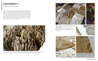
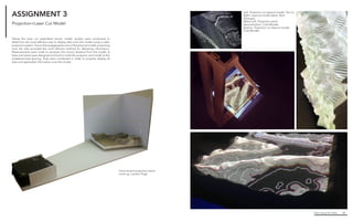
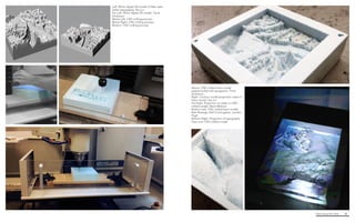
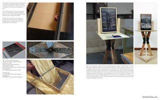
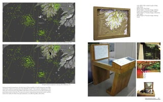
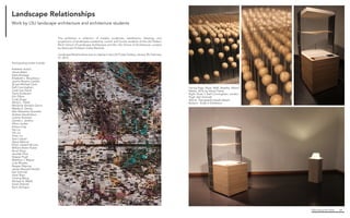
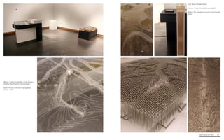
![Fabricating the Delta 44
Above. Steel armature
detail
Left. Wooden siding detail
Below Left. Full-sized entire
kiosk, final design
Below Right. Detail of
suspended wooden
beads representing
change in topography and
bathymetry levels
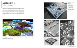
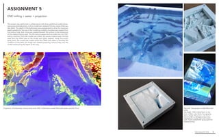
The installation shows topographic and bathymetric changes in Wax Lake
Delta between 1941 and 2012. While topography and bathymetry datasets are
represented as continuous, this data is extrapolated from collections of point
data; in addition, a continuous method of representation is not well attuned to
the characteristics of deltaic environments. As such, topography [ air / land ] and
bathymetry [ land / water ] are shown via a point cloud representing the changes
in elevation and depth at the intersection of a nominal grid and the Wax Lake
Delta. In addition to the altered means of representation, the use of a point cloud
also imbues an ephemerality and the suggestion of continual movement and
change.
Project team :
Kelli Cunningham M.Arch/MLA 2016
Landon Pugh M.Arch 2015
Karl lane Schmidt M.Arch/MLA 2016
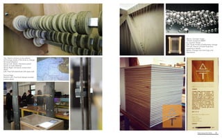
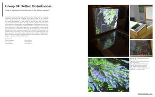
Group 01 Delta Over Time
How to represent changing bathymetry / topography over time?](https://image.slidesharecdn.com/fabricatingthedeltaforweb-150707213101-lva1-app6892/85/Fabricating-the-delta-for-web-22-320.jpg)


The document discusses research on the Wax Lake Delta in Louisiana. It provides background on the delta's formation from sediment deposition from the Atchafalaya River. Research is being conducted through the DELTA LAB observatory to understand delta evolution and inform coastal restoration efforts. Dense instrumentation is used to study physical, ecological and geochemical processes during events like floods and storms. The data aims to improve predictive models of delta growth and benefit delta management worldwide.


