Download as PDF, PPTX


![© 2015 EnterpriseDB Corporation. All rights reserved. 20
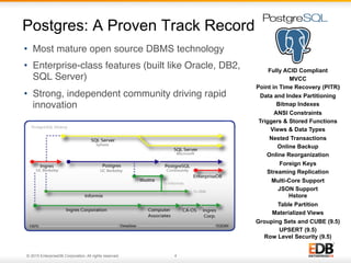
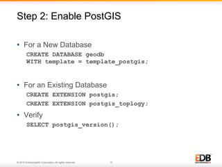
• Output geometry data types to other data types
SELECT st_astext(geom), st_asgeojson(geom),
stasgml(geom) FROM atm_locations LIMIT 1;
-[ RECORD 1 ]+----------------------------------
st_astext | POINT(-81.7842060002066 30.2915309995561)
st_asgeojson | {"type":"Point","coordinates":
[-81.7842060002066,30.2915309995561]}
st_asgml | <gml:Point srsName="EPSG:
4629"><gml:coordinates>-81.784206000206609,30.2915309995
5613</gml:coordinates></gml:Point>
Geometry Input and Output Functions
20](https://image.slidesharecdn.com/getting-150930203034-lva1-app6891/85/Getting-Started-with-PostGIS-20-320.jpg)


This document serves as an introduction to PostGIS and its integration with PostgreSQL, highlighting the database's enterprise-class features and compatibility. It outlines the steps for installing PostGIS, enabling it in databases, loading geospatial data, and providing examples of spatial queries. Additionally, it emphasizes maintenance practices and advanced functionalities available in PostgreSQL for geospatial applications.


![지리정보체계(GIS) - [1] GIS 데이터 유형, 구조 알기](https://cdn.slidesharecdn.com/ss_thumbnails/sugis2018c01-180902151613-thumbnail.jpg?width=640&height=640&fit=bounds)


![지리정보체계(GIS) - [2] 좌표계 이해하기](https://cdn.slidesharecdn.com/ss_thumbnails/sugis2018c02-180916155653-thumbnail.jpg?width=640&height=640&fit=bounds)

![[Pgday.Seoul 2019] Citus를 이용한 분산 데이터베이스](https://cdn.slidesharecdn.com/ss_thumbnails/citus20191207studypgday-191218045308-thumbnail.jpg?width=640&height=640&fit=bounds)


![Lect 1 Number systems and base conversions. [Autosaved].pptx](https://cdn.slidesharecdn.com/ss_thumbnails/lect1numbersystemsandbaseconversions-260111134109-67c2d865-thumbnail.jpg?width=640&height=640&fit=bounds)


