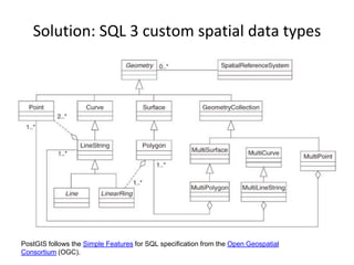
SlideShare a Scribd company logo
Why is PostGIS awesome?
Reason 1: it is open source
Kasper Van Lombeek - Forespell.com
17 / 11 / 2016 - DS Meetup Antwerp
First we need to understand:
Why did SQL need an extension?
Problem 1: data storage
Try to store this rectangle in a db
A db that allows only atomic data
points.
P1 P2
P3P4
Lets tryPid X Y
P1 0 0
P2 0 1
P3 1 1
P4 1 0
Table 1: points
Eid Pid
E1 P1
E1 P2
E2 P2
E2
…
P3
…
Table 3: Starts_or_ends
Eid Length
E1 1
E2 1
E3 1
E4 1
Table 2: Edges
P1 P2
P3P4
E1
E2
E3
E4
Rid Eid
R1 E1
R1 E2
R1 E3
R1
…
E4
…
Table 4: Boundary
Rid Rname
R1 UnitSquare
Table 5: Rectangle
Lets try storing all the neighbourhoods
in Belgium?
Solution: SQL 3 custom spatial data types
PostGIS follows the Simple Features for SQL specification from the Open Geospatial
Consortium (OGC).
Problem 2: querying the
database
How to query our db?
Describe in words how to query the
points within the rectangle.
What about a more complex shape?
Would your query still work?
Solution: spatial operators
Provided by GEOS - Geometry Engine, Open Source
Problem 3: querying the
database fast
In which area do we have most
bicycle thefts?
Need for an index
Solution: spatial index
R-tree implementation of bounding boxes of geometries
These three solutions are integrated
in PostGIS
- Geometry types for Points, LineStrings, Polygons, MultiPoints, MultiLineStrings, MultipPolygons and
GeometryCollections.
- Spatial predicates for determining the interactions of geometries using the 3x3 DE-9IM (provided by the GEOS
software library).
- Spatial operators for determining geospatial measurements like area, distance, length and perimeter.
- Spatial operators for determining geospatial set operations, like union, difference, symmetric difference and
buffers (provided by GEOS).
- R-tree-over-GiST (Generalized Search Tree) spatial indexes for high speed spatial querying.
- Index selectivity support, to provide high performance query plans for mixed spatial/non-spatial queries.
- For raster data, PostGIS WKT Raster (now integrated into PostGIS 2.0+ and renamed PostGIS Raster)
- The PostGIS implementation is based on "light-weight" geometries and indexes optimized to reduce disk and
memory footprint. Using light-weight geometries helps servers increase the amount of data migrated up from
physical disk storage into RAM, improving query performance substantially.
- PostGIS is registered as "implements the specified standard" for "Simple Features for SQL" by the OGC.[2]
PostGIS has not been certified as compliant by the OGC. For the OGC's definition of compliant, see What does
"Compliant" mean?.
Source: wikipedia
Demo in IPython notebook

More Related Content

What's hot

WMS Performance Shootout 2011
WMS Performance Shootout 2011WMS Performance Shootout 2011
WMS Performance Shootout 2011
Jeff McKenna
 
Wms Performance Tests Map Server Vs Geo Server
Wms Performance Tests Map Server Vs Geo ServerWms Performance Tests Map Server Vs Geo Server
Wms Performance Tests Map Server Vs Geo ServerDonnyV
 
GeoServer on Steroids at FOSS4G Europe 2014
GeoServer on Steroids at FOSS4G Europe 2014GeoServer on Steroids at FOSS4G Europe 2014
GeoServer on Steroids at FOSS4G Europe 2014
GeoSolutions
 
Using GeoServer for spatio-temporal data management with examples for MetOc a...
Using GeoServer for spatio-temporal data management with examples for MetOc a...Using GeoServer for spatio-temporal data management with examples for MetOc a...
Using GeoServer for spatio-temporal data management with examples for MetOc a...
GeoSolutions
 
Crunching Data In GeoServer: Mastering Rendering Transformations, WPS Process...
Crunching Data In GeoServer: Mastering Rendering Transformations, WPS Process...Crunching Data In GeoServer: Mastering Rendering Transformations, WPS Process...
Crunching Data In GeoServer: Mastering Rendering Transformations, WPS Process...
GeoSolutions
 
Overview of MassGIS Web Mapping Services
Overview of MassGIS Web Mapping ServicesOverview of MassGIS Web Mapping Services
Overview of MassGIS Web Mapping Services
aleda_freeman
 
Spatial functions in MySQL 5.6, MariaDB 5.5, PostGIS 2.0 and others
Spatial functions in  MySQL 5.6, MariaDB 5.5, PostGIS 2.0 and othersSpatial functions in  MySQL 5.6, MariaDB 5.5, PostGIS 2.0 and others
Spatial functions in MySQL 5.6, MariaDB 5.5, PostGIS 2.0 and othersHenrik Ingo
 
GeoServer in Production: we do it, here is how!
GeoServer in Production: we do it, here is how!GeoServer in Production: we do it, here is how!
GeoServer in Production: we do it, here is how!
GeoSolutions
 
HDF5 Performance Enhancements with the Elimination of Unlimited Dimension
HDF5 Performance Enhancements with the Elimination of Unlimited DimensionHDF5 Performance Enhancements with the Elimination of Unlimited Dimension
HDF5 Performance Enhancements with the Elimination of Unlimited Dimension
The HDF-EOS Tools and Information Center
 
MySQL 5.7 GIS
MySQL 5.7 GISMySQL 5.7 GIS
MySQL 5.7 GIS
Pavan Naik
 
MapServer #ProTips 2015
MapServer #ProTips 2015MapServer #ProTips 2015
MapServer #ProTips 2015
Jeff McKenna
 
State of GeoServer - FOSS4G 2016
State of GeoServer - FOSS4G 2016State of GeoServer - FOSS4G 2016
State of GeoServer - FOSS4G 2016
GeoSolutions
 
Enterprise class deployment for GeoServer and GeoWebcache Optimizing perform...
Enterprise class deployment  for GeoServer and GeoWebcache Optimizing perform...Enterprise class deployment  for GeoServer and GeoWebcache Optimizing perform...
Enterprise class deployment for GeoServer and GeoWebcache Optimizing perform...
GeoSolutions
 
Big size meteorological data processing and mobile displaying system using ...
Big size meteorological data processing and mobile displaying system using ...Big size meteorological data processing and mobile displaying system using ...
Big size meteorological data processing and mobile displaying system using ...
BJ Jang
 
GeoServer on steroids
GeoServer on steroidsGeoServer on steroids
GeoServer on steroids
GeoSolutions
 
OSM data in MariaDB / MySQL - All the world in a few large tables
OSM data in MariaDB / MySQL - All the world in a few large tablesOSM data in MariaDB / MySQL - All the world in a few large tables
OSM data in MariaDB / MySQL - All the world in a few large tables
hholzgra
 
GeoServer, an introduction for beginners
GeoServer, an introduction for beginnersGeoServer, an introduction for beginners
GeoServer, an introduction for beginners
GeoSolutions
 
Processing Geospatial at Scale at LocationTech
Processing Geospatial at Scale at LocationTechProcessing Geospatial at Scale at LocationTech
Processing Geospatial at Scale at LocationTech
Rob Emanuele
 
Spatio-temporal Data Handling With GeoServer for MetOc And Remote Sensing
Spatio-temporal Data Handling With GeoServer for MetOc And Remote SensingSpatio-temporal Data Handling With GeoServer for MetOc And Remote Sensing
Spatio-temporal Data Handling With GeoServer for MetOc And Remote Sensing
GeoSolutions
 
GeoServer on Steroids
GeoServer on Steroids GeoServer on Steroids
GeoServer on Steroids
GeoSolutions
 

What's hot (20)

WMS Performance Shootout 2011
WMS Performance Shootout 2011WMS Performance Shootout 2011
WMS Performance Shootout 2011
 
Wms Performance Tests Map Server Vs Geo Server
Wms Performance Tests Map Server Vs Geo ServerWms Performance Tests Map Server Vs Geo Server
Wms Performance Tests Map Server Vs Geo Server
 
GeoServer on Steroids at FOSS4G Europe 2014
GeoServer on Steroids at FOSS4G Europe 2014GeoServer on Steroids at FOSS4G Europe 2014
GeoServer on Steroids at FOSS4G Europe 2014
 
Using GeoServer for spatio-temporal data management with examples for MetOc a...
Using GeoServer for spatio-temporal data management with examples for MetOc a...Using GeoServer for spatio-temporal data management with examples for MetOc a...
Using GeoServer for spatio-temporal data management with examples for MetOc a...
 
Crunching Data In GeoServer: Mastering Rendering Transformations, WPS Process...
Crunching Data In GeoServer: Mastering Rendering Transformations, WPS Process...Crunching Data In GeoServer: Mastering Rendering Transformations, WPS Process...
Crunching Data In GeoServer: Mastering Rendering Transformations, WPS Process...
 
Overview of MassGIS Web Mapping Services
Overview of MassGIS Web Mapping ServicesOverview of MassGIS Web Mapping Services
Overview of MassGIS Web Mapping Services
 
Spatial functions in MySQL 5.6, MariaDB 5.5, PostGIS 2.0 and others
Spatial functions in  MySQL 5.6, MariaDB 5.5, PostGIS 2.0 and othersSpatial functions in  MySQL 5.6, MariaDB 5.5, PostGIS 2.0 and others
Spatial functions in MySQL 5.6, MariaDB 5.5, PostGIS 2.0 and others
 
GeoServer in Production: we do it, here is how!
GeoServer in Production: we do it, here is how!GeoServer in Production: we do it, here is how!
GeoServer in Production: we do it, here is how!
 
HDF5 Performance Enhancements with the Elimination of Unlimited Dimension
HDF5 Performance Enhancements with the Elimination of Unlimited DimensionHDF5 Performance Enhancements with the Elimination of Unlimited Dimension
HDF5 Performance Enhancements with the Elimination of Unlimited Dimension
 
MySQL 5.7 GIS
MySQL 5.7 GISMySQL 5.7 GIS
MySQL 5.7 GIS
 
MapServer #ProTips 2015
MapServer #ProTips 2015MapServer #ProTips 2015
MapServer #ProTips 2015
 
State of GeoServer - FOSS4G 2016
State of GeoServer - FOSS4G 2016State of GeoServer - FOSS4G 2016
State of GeoServer - FOSS4G 2016
 
Enterprise class deployment for GeoServer and GeoWebcache Optimizing perform...
Enterprise class deployment  for GeoServer and GeoWebcache Optimizing perform...Enterprise class deployment  for GeoServer and GeoWebcache Optimizing perform...
Enterprise class deployment for GeoServer and GeoWebcache Optimizing perform...
 
Big size meteorological data processing and mobile displaying system using ...
Big size meteorological data processing and mobile displaying system using ...Big size meteorological data processing and mobile displaying system using ...
Big size meteorological data processing and mobile displaying system using ...
 
GeoServer on steroids
GeoServer on steroidsGeoServer on steroids
GeoServer on steroids
 
OSM data in MariaDB / MySQL - All the world in a few large tables
OSM data in MariaDB / MySQL - All the world in a few large tablesOSM data in MariaDB / MySQL - All the world in a few large tables
OSM data in MariaDB / MySQL - All the world in a few large tables
 
GeoServer, an introduction for beginners
GeoServer, an introduction for beginnersGeoServer, an introduction for beginners
GeoServer, an introduction for beginners
 
Processing Geospatial at Scale at LocationTech
Processing Geospatial at Scale at LocationTechProcessing Geospatial at Scale at LocationTech
Processing Geospatial at Scale at LocationTech
 
Spatio-temporal Data Handling With GeoServer for MetOc And Remote Sensing
Spatio-temporal Data Handling With GeoServer for MetOc And Remote SensingSpatio-temporal Data Handling With GeoServer for MetOc And Remote Sensing
Spatio-temporal Data Handling With GeoServer for MetOc And Remote Sensing
 
GeoServer on Steroids
GeoServer on Steroids GeoServer on Steroids
GeoServer on Steroids
 

Viewers also liked

Postgis for Enterprise
Postgis for EnterprisePostgis for Enterprise
Postgis for Enterprise
GeoLivre Conference
 
Using PostGIS in Local Government (Enterprise)
Using PostGIS in Local Government (Enterprise) Using PostGIS in Local Government (Enterprise)
Using PostGIS in Local Government (Enterprise)
Dave Michelson
 
Beyond Postgres: Interesting Projects, Tools and forks
Beyond Postgres: Interesting Projects, Tools and forksBeyond Postgres: Interesting Projects, Tools and forks
Beyond Postgres: Interesting Projects, Tools and forks
Sameer Kumar
 
Introduction of Open Source GIS
Introduction of Open Source GISIntroduction of Open Source GIS
Introduction of Open Source GIS
SANGHEE SHIN
 
Sistemas de Información Geográfica Libres - Flisol 2016
Sistemas de Información Geográfica Libres - Flisol 2016Sistemas de Información Geográfica Libres - Flisol 2016
Sistemas de Información Geográfica Libres - Flisol 2016
Plattinux
 
Quoi de neuf dans post gis 2.0 le raster bien sur mais beaucoup plus
Quoi de neuf dans post gis 2.0 le raster bien sur mais beaucoup plusQuoi de neuf dans post gis 2.0 le raster bien sur mais beaucoup plus
Quoi de neuf dans post gis 2.0 le raster bien sur mais beaucoup plusVisionGÉOMATIQUE2012
 
QGIS et WebSIG(s), la convergence ?
QGIS et WebSIG(s), la convergence ?QGIS et WebSIG(s), la convergence ?
QGIS et WebSIG(s), la convergence ?Camptocamp
 
Performance and Application of GIS and Big Data ETL Processes Using FME
Performance and Application of GIS and Big Data ETL Processes Using FMEPerformance and Application of GIS and Big Data ETL Processes Using FME
Performance and Application of GIS and Big Data ETL Processes Using FME
Safe Software
 
State of GeoServer 2.10
State of GeoServer 2.10State of GeoServer 2.10
State of GeoServer 2.10
Jody Garnett
 
SIG open source : aperçu et comparaisons - présentation AGMQ 30 avril 2009
SIG open source : aperçu et comparaisons - présentation AGMQ 30 avril 2009SIG open source : aperçu et comparaisons - présentation AGMQ 30 avril 2009
SIG open source : aperçu et comparaisons - présentation AGMQ 30 avril 2009
Mathieu Lahaye
 
OpenLayers vs. Leaflet
OpenLayers vs. LeafletOpenLayers vs. Leaflet
OpenLayers vs. Leaflet
dasjo
 
Use Case: PostGIS and Agribotics
Use Case: PostGIS and AgriboticsUse Case: PostGIS and Agribotics
Use Case: PostGIS and Agribotics
PGConf APAC
 

Viewers also liked (12)

Postgis for Enterprise
Postgis for EnterprisePostgis for Enterprise
Postgis for Enterprise
 
Using PostGIS in Local Government (Enterprise)
Using PostGIS in Local Government (Enterprise) Using PostGIS in Local Government (Enterprise)
Using PostGIS in Local Government (Enterprise)
 
Beyond Postgres: Interesting Projects, Tools and forks
Beyond Postgres: Interesting Projects, Tools and forksBeyond Postgres: Interesting Projects, Tools and forks
Beyond Postgres: Interesting Projects, Tools and forks
 
Introduction of Open Source GIS
Introduction of Open Source GISIntroduction of Open Source GIS
Introduction of Open Source GIS
 
Sistemas de Información Geográfica Libres - Flisol 2016
Sistemas de Información Geográfica Libres - Flisol 2016Sistemas de Información Geográfica Libres - Flisol 2016
Sistemas de Información Geográfica Libres - Flisol 2016
 
Quoi de neuf dans post gis 2.0 le raster bien sur mais beaucoup plus
Quoi de neuf dans post gis 2.0 le raster bien sur mais beaucoup plusQuoi de neuf dans post gis 2.0 le raster bien sur mais beaucoup plus
Quoi de neuf dans post gis 2.0 le raster bien sur mais beaucoup plus
 
QGIS et WebSIG(s), la convergence ?
QGIS et WebSIG(s), la convergence ?QGIS et WebSIG(s), la convergence ?
QGIS et WebSIG(s), la convergence ?
 
Performance and Application of GIS and Big Data ETL Processes Using FME
Performance and Application of GIS and Big Data ETL Processes Using FMEPerformance and Application of GIS and Big Data ETL Processes Using FME
Performance and Application of GIS and Big Data ETL Processes Using FME
 
State of GeoServer 2.10
State of GeoServer 2.10State of GeoServer 2.10
State of GeoServer 2.10
 
SIG open source : aperçu et comparaisons - présentation AGMQ 30 avril 2009
SIG open source : aperçu et comparaisons - présentation AGMQ 30 avril 2009SIG open source : aperçu et comparaisons - présentation AGMQ 30 avril 2009
SIG open source : aperçu et comparaisons - présentation AGMQ 30 avril 2009
 
OpenLayers vs. Leaflet
OpenLayers vs. LeafletOpenLayers vs. Leaflet
OpenLayers vs. Leaflet
 
Use Case: PostGIS and Agribotics
Use Case: PostGIS and AgriboticsUse Case: PostGIS and Agribotics
Use Case: PostGIS and Agribotics
 

Similar to Why is postgis awesome?

introduction to geographical information system
introduction to geographical information systemintroduction to geographical information system
introduction to geographical information system
DrVenkateswarluGogan1
 
No(Geo)SQL
No(Geo)SQLNo(Geo)SQL
Accumulo Summit 2016: GeoMesa: Using Accumulo for Optimized Spatio-Temporal P...
Accumulo Summit 2016: GeoMesa: Using Accumulo for Optimized Spatio-Temporal P...Accumulo Summit 2016: GeoMesa: Using Accumulo for Optimized Spatio-Temporal P...
Accumulo Summit 2016: GeoMesa: Using Accumulo for Optimized Spatio-Temporal P...
Accumulo Summit
 
Geographical Information System (GIS)
Geographical Information System (GIS)Geographical Information System (GIS)
Geographical Information System (GIS)
Malla Reddy University
 
Magellan FOSS4G Talk, Boston 2017
Magellan FOSS4G Talk, Boston 2017Magellan FOSS4G Talk, Boston 2017
Magellan FOSS4G Talk, Boston 2017
Ram Sriharsha
 
Geonuris ep introduction 3.0 english sg
Geonuris ep introduction 3.0 english sgGeonuris ep introduction 3.0 english sg
Geonuris ep introduction 3.0 english sgSTLogic
 
Dsm Presentation
Dsm PresentationDsm Presentation
Dsm Presentationrichoe
 
Giving MongoDB a Way to Play with the GIS Community
Giving MongoDB a Way to Play with the GIS CommunityGiving MongoDB a Way to Play with the GIS Community
Giving MongoDB a Way to Play with the GIS Community
MongoDB
 
OSGeo Conferences Report
OSGeo Conferences ReportOSGeo Conferences Report
OSGeo Conferences Report
Jeff McKenna
 
Big data distributed processing: Spark introduction
Big data distributed processing: Spark introductionBig data distributed processing: Spark introduction
Big data distributed processing: Spark introduction
Hektor Jacynycz García
 
Open Source Databases And Gis
Open Source Databases And GisOpen Source Databases And Gis
Open Source Databases And Gis
Kudos S.A.S
 
High Dimensional Indexing using MongoDB (MongoSV 2012)
High Dimensional Indexing using MongoDB (MongoSV 2012)High Dimensional Indexing using MongoDB (MongoSV 2012)
High Dimensional Indexing using MongoDB (MongoSV 2012)Nicholas Knize, Ph.D., GISP
 
NAPSG 2010 Fire/EMS Conference - Data Sharing Basics
NAPSG 2010 Fire/EMS Conference - Data Sharing BasicsNAPSG 2010 Fire/EMS Conference - Data Sharing Basics
NAPSG 2010 Fire/EMS Conference - Data Sharing Basicspdituri
 
State of JTS 2018
State of JTS 2018State of JTS 2018
State of JTS 2018
Jody Garnett
 
Geographica: A Benchmark for Geospatial RDF Stores
Geographica: A Benchmark for Geospatial RDF StoresGeographica: A Benchmark for Geospatial RDF Stores
Geographica: A Benchmark for Geospatial RDF Stores
Kostis Kyzirakos
 
Hardware Implementations of RS Decoding Algorithm for Multi-Gb/s Communicatio...
Hardware Implementations of RS Decoding Algorithm for Multi-Gb/s Communicatio...Hardware Implementations of RS Decoding Algorithm for Multi-Gb/s Communicatio...
Hardware Implementations of RS Decoding Algorithm for Multi-Gb/s Communicatio...
RSIS International
 
Pg intro part1-theory_slides
Pg intro part1-theory_slidesPg intro part1-theory_slides
Pg intro part1-theory_slideslasmasi
 
Building Location Aware Apps - Get Started with PostGIS, PART I
Building Location Aware Apps - Get Started with PostGIS, PART IBuilding Location Aware Apps - Get Started with PostGIS, PART I
Building Location Aware Apps - Get Started with PostGIS, PART I
lasmasi
 
Building a Spatial Database in PostgreSQL
Building a Spatial Database in PostgreSQLBuilding a Spatial Database in PostgreSQL
Building a Spatial Database in PostgreSQL
Kudos S.A.S
 

Similar to Why is postgis awesome? (20)

ADAPTER
ADAPTERADAPTER
ADAPTER
 
introduction to geographical information system
introduction to geographical information systemintroduction to geographical information system
introduction to geographical information system
 
No(Geo)SQL
No(Geo)SQLNo(Geo)SQL
No(Geo)SQL
 
Accumulo Summit 2016: GeoMesa: Using Accumulo for Optimized Spatio-Temporal P...
Accumulo Summit 2016: GeoMesa: Using Accumulo for Optimized Spatio-Temporal P...Accumulo Summit 2016: GeoMesa: Using Accumulo for Optimized Spatio-Temporal P...
Accumulo Summit 2016: GeoMesa: Using Accumulo for Optimized Spatio-Temporal P...
 
Geographical Information System (GIS)
Geographical Information System (GIS)Geographical Information System (GIS)
Geographical Information System (GIS)
 
Magellan FOSS4G Talk, Boston 2017
Magellan FOSS4G Talk, Boston 2017Magellan FOSS4G Talk, Boston 2017
Magellan FOSS4G Talk, Boston 2017
 
Geonuris ep introduction 3.0 english sg
Geonuris ep introduction 3.0 english sgGeonuris ep introduction 3.0 english sg
Geonuris ep introduction 3.0 english sg
 
Dsm Presentation
Dsm PresentationDsm Presentation
Dsm Presentation
 
Giving MongoDB a Way to Play with the GIS Community
Giving MongoDB a Way to Play with the GIS CommunityGiving MongoDB a Way to Play with the GIS Community
Giving MongoDB a Way to Play with the GIS Community
 
OSGeo Conferences Report
OSGeo Conferences ReportOSGeo Conferences Report
OSGeo Conferences Report
 
Big data distributed processing: Spark introduction
Big data distributed processing: Spark introductionBig data distributed processing: Spark introduction
Big data distributed processing: Spark introduction
 
Open Source Databases And Gis
Open Source Databases And GisOpen Source Databases And Gis
Open Source Databases And Gis
 
High Dimensional Indexing using MongoDB (MongoSV 2012)
High Dimensional Indexing using MongoDB (MongoSV 2012)High Dimensional Indexing using MongoDB (MongoSV 2012)
High Dimensional Indexing using MongoDB (MongoSV 2012)
 
NAPSG 2010 Fire/EMS Conference - Data Sharing Basics
NAPSG 2010 Fire/EMS Conference - Data Sharing BasicsNAPSG 2010 Fire/EMS Conference - Data Sharing Basics
NAPSG 2010 Fire/EMS Conference - Data Sharing Basics
 
State of JTS 2018
State of JTS 2018State of JTS 2018
State of JTS 2018
 
Geographica: A Benchmark for Geospatial RDF Stores
Geographica: A Benchmark for Geospatial RDF StoresGeographica: A Benchmark for Geospatial RDF Stores
Geographica: A Benchmark for Geospatial RDF Stores
 
Hardware Implementations of RS Decoding Algorithm for Multi-Gb/s Communicatio...
Hardware Implementations of RS Decoding Algorithm for Multi-Gb/s Communicatio...Hardware Implementations of RS Decoding Algorithm for Multi-Gb/s Communicatio...
Hardware Implementations of RS Decoding Algorithm for Multi-Gb/s Communicatio...
 
Pg intro part1-theory_slides
Pg intro part1-theory_slidesPg intro part1-theory_slides
Pg intro part1-theory_slides
 
Building Location Aware Apps - Get Started with PostGIS, PART I
Building Location Aware Apps - Get Started with PostGIS, PART IBuilding Location Aware Apps - Get Started with PostGIS, PART I
Building Location Aware Apps - Get Started with PostGIS, PART I
 
Building a Spatial Database in PostgreSQL
Building a Spatial Database in PostgreSQLBuilding a Spatial Database in PostgreSQL
Building a Spatial Database in PostgreSQL
 

Recently uploaded

一比一原版(ArtEZ毕业证)ArtEZ艺术学院毕业证成绩单
一比一原版(ArtEZ毕业证)ArtEZ艺术学院毕业证成绩单一比一原版(ArtEZ毕业证)ArtEZ艺术学院毕业证成绩单
一比一原版(ArtEZ毕业证)ArtEZ艺术学院毕业证成绩单
vcaxypu
 
Best best suvichar in gujarati english meaning of this sentence as Silk road ...
Best best suvichar in gujarati english meaning of this sentence as Silk road ...Best best suvichar in gujarati english meaning of this sentence as Silk road ...
Best best suvichar in gujarati english meaning of this sentence as Silk road ...
AbhimanyuSinha9
 
FP Growth Algorithm and its Applications
FP Growth Algorithm and its ApplicationsFP Growth Algorithm and its Applications
FP Growth Algorithm and its Applications
MaleehaSheikh2
 
一比一原版(Coventry毕业证书)考文垂大学毕业证如何办理
一比一原版(Coventry毕业证书)考文垂大学毕业证如何办理一比一原版(Coventry毕业证书)考文垂大学毕业证如何办理
一比一原版(Coventry毕业证书)考文垂大学毕业证如何办理
74nqk8xf
 
The affect of service quality and online reviews on customer loyalty in the E...
The affect of service quality and online reviews on customer loyalty in the E...The affect of service quality and online reviews on customer loyalty in the E...
The affect of service quality and online reviews on customer loyalty in the E...
jerlynmaetalle
 
一比一原版(Deakin毕业证书)迪肯大学毕业证如何办理
一比一原版(Deakin毕业证书)迪肯大学毕业证如何办理一比一原版(Deakin毕业证书)迪肯大学毕业证如何办理
一比一原版(Deakin毕业证书)迪肯大学毕业证如何办理
oz8q3jxlp
 
Criminal IP - Threat Hunting Webinar.pdf
Criminal IP - Threat Hunting Webinar.pdfCriminal IP - Threat Hunting Webinar.pdf
Criminal IP - Threat Hunting Webinar.pdf
Criminal IP
 
一比一原版(CBU毕业证)不列颠海角大学毕业证成绩单
一比一原版(CBU毕业证)不列颠海角大学毕业证成绩单一比一原版(CBU毕业证)不列颠海角大学毕业证成绩单
一比一原版(CBU毕业证)不列颠海角大学毕业证成绩单
nscud
 
一比一原版(BCU毕业证书)伯明翰城市大学毕业证如何办理
一比一原版(BCU毕业证书)伯明翰城市大学毕业证如何办理一比一原版(BCU毕业证书)伯明翰城市大学毕业证如何办理
一比一原版(BCU毕业证书)伯明翰城市大学毕业证如何办理
dwreak4tg
 
一比一原版(CBU毕业证)卡普顿大学毕业证成绩单
一比一原版(CBU毕业证)卡普顿大学毕业证成绩单一比一原版(CBU毕业证)卡普顿大学毕业证成绩单
一比一原版(CBU毕业证)卡普顿大学毕业证成绩单
nscud
 
Q1’2024 Update: MYCI’s Leap Year Rebound
Q1’2024 Update: MYCI’s Leap Year ReboundQ1’2024 Update: MYCI’s Leap Year Rebound
Q1’2024 Update: MYCI’s Leap Year Rebound
Oppotus
 
standardisation of garbhpala offhgfffghh
standardisation of garbhpala offhgfffghhstandardisation of garbhpala offhgfffghh
standardisation of garbhpala offhgfffghh
ArpitMalhotra16
 
一比一原版(UofM毕业证)明尼苏达大学毕业证成绩单
一比一原版(UofM毕业证)明尼苏达大学毕业证成绩单一比一原版(UofM毕业证)明尼苏达大学毕业证成绩单
一比一原版(UofM毕业证)明尼苏达大学毕业证成绩单
ewymefz
 
哪里卖(usq毕业证书)南昆士兰大学毕业证研究生文凭证书托福证书原版一模一样
哪里卖(usq毕业证书)南昆士兰大学毕业证研究生文凭证书托福证书原版一模一样哪里卖(usq毕业证书)南昆士兰大学毕业证研究生文凭证书托福证书原版一模一样
哪里卖(usq毕业证书)南昆士兰大学毕业证研究生文凭证书托福证书原版一模一样
axoqas
 
一比一原版(QU毕业证)皇后大学毕业证成绩单
一比一原版(QU毕业证)皇后大学毕业证成绩单一比一原版(QU毕业证)皇后大学毕业证成绩单
一比一原版(QU毕业证)皇后大学毕业证成绩单
enxupq
 
Malana- Gimlet Market Analysis (Portfolio 2)
Malana- Gimlet Market Analysis (Portfolio 2)Malana- Gimlet Market Analysis (Portfolio 2)
Malana- Gimlet Market Analysis (Portfolio 2)
TravisMalana
 
Data_and_Analytics_Essentials_Architect_an_Analytics_Platform.pptx
Data_and_Analytics_Essentials_Architect_an_Analytics_Platform.pptxData_and_Analytics_Essentials_Architect_an_Analytics_Platform.pptx
Data_and_Analytics_Essentials_Architect_an_Analytics_Platform.pptx
AnirbanRoy608946
 
Quantitative Data AnalysisReliability Analysis (Cronbach Alpha) Common Method...
Quantitative Data AnalysisReliability Analysis (Cronbach Alpha) Common Method...Quantitative Data AnalysisReliability Analysis (Cronbach Alpha) Common Method...
Quantitative Data AnalysisReliability Analysis (Cronbach Alpha) Common Method...
2023240532
 
Empowering Data Analytics Ecosystem.pptx
Empowering Data Analytics Ecosystem.pptxEmpowering Data Analytics Ecosystem.pptx
Empowering Data Analytics Ecosystem.pptx
benishzehra469
 
一比一原版(UniSA毕业证书)南澳大学毕业证如何办理
一比一原版(UniSA毕业证书)南澳大学毕业证如何办理一比一原版(UniSA毕业证书)南澳大学毕业证如何办理
一比一原版(UniSA毕业证书)南澳大学毕业证如何办理
slg6lamcq
 

Recently uploaded (20)

一比一原版(ArtEZ毕业证)ArtEZ艺术学院毕业证成绩单
一比一原版(ArtEZ毕业证)ArtEZ艺术学院毕业证成绩单一比一原版(ArtEZ毕业证)ArtEZ艺术学院毕业证成绩单
一比一原版(ArtEZ毕业证)ArtEZ艺术学院毕业证成绩单
 
Best best suvichar in gujarati english meaning of this sentence as Silk road ...
Best best suvichar in gujarati english meaning of this sentence as Silk road ...Best best suvichar in gujarati english meaning of this sentence as Silk road ...
Best best suvichar in gujarati english meaning of this sentence as Silk road ...
 
FP Growth Algorithm and its Applications
FP Growth Algorithm and its ApplicationsFP Growth Algorithm and its Applications
FP Growth Algorithm and its Applications
 
一比一原版(Coventry毕业证书)考文垂大学毕业证如何办理
一比一原版(Coventry毕业证书)考文垂大学毕业证如何办理一比一原版(Coventry毕业证书)考文垂大学毕业证如何办理
一比一原版(Coventry毕业证书)考文垂大学毕业证如何办理
 
The affect of service quality and online reviews on customer loyalty in the E...
The affect of service quality and online reviews on customer loyalty in the E...The affect of service quality and online reviews on customer loyalty in the E...
The affect of service quality and online reviews on customer loyalty in the E...
 
一比一原版(Deakin毕业证书)迪肯大学毕业证如何办理
一比一原版(Deakin毕业证书)迪肯大学毕业证如何办理一比一原版(Deakin毕业证书)迪肯大学毕业证如何办理
一比一原版(Deakin毕业证书)迪肯大学毕业证如何办理
 
Criminal IP - Threat Hunting Webinar.pdf
Criminal IP - Threat Hunting Webinar.pdfCriminal IP - Threat Hunting Webinar.pdf
Criminal IP - Threat Hunting Webinar.pdf
 
一比一原版(CBU毕业证)不列颠海角大学毕业证成绩单
一比一原版(CBU毕业证)不列颠海角大学毕业证成绩单一比一原版(CBU毕业证)不列颠海角大学毕业证成绩单
一比一原版(CBU毕业证)不列颠海角大学毕业证成绩单
 
一比一原版(BCU毕业证书)伯明翰城市大学毕业证如何办理
一比一原版(BCU毕业证书)伯明翰城市大学毕业证如何办理一比一原版(BCU毕业证书)伯明翰城市大学毕业证如何办理
一比一原版(BCU毕业证书)伯明翰城市大学毕业证如何办理
 
一比一原版(CBU毕业证)卡普顿大学毕业证成绩单
一比一原版(CBU毕业证)卡普顿大学毕业证成绩单一比一原版(CBU毕业证)卡普顿大学毕业证成绩单
一比一原版(CBU毕业证)卡普顿大学毕业证成绩单
 
Q1’2024 Update: MYCI’s Leap Year Rebound
Q1’2024 Update: MYCI’s Leap Year ReboundQ1’2024 Update: MYCI’s Leap Year Rebound
Q1’2024 Update: MYCI’s Leap Year Rebound
 
standardisation of garbhpala offhgfffghh
standardisation of garbhpala offhgfffghhstandardisation of garbhpala offhgfffghh
standardisation of garbhpala offhgfffghh
 
一比一原版(UofM毕业证)明尼苏达大学毕业证成绩单
一比一原版(UofM毕业证)明尼苏达大学毕业证成绩单一比一原版(UofM毕业证)明尼苏达大学毕业证成绩单
一比一原版(UofM毕业证)明尼苏达大学毕业证成绩单
 
哪里卖(usq毕业证书)南昆士兰大学毕业证研究生文凭证书托福证书原版一模一样
哪里卖(usq毕业证书)南昆士兰大学毕业证研究生文凭证书托福证书原版一模一样哪里卖(usq毕业证书)南昆士兰大学毕业证研究生文凭证书托福证书原版一模一样
哪里卖(usq毕业证书)南昆士兰大学毕业证研究生文凭证书托福证书原版一模一样
 
一比一原版(QU毕业证)皇后大学毕业证成绩单
一比一原版(QU毕业证)皇后大学毕业证成绩单一比一原版(QU毕业证)皇后大学毕业证成绩单
一比一原版(QU毕业证)皇后大学毕业证成绩单
 
Malana- Gimlet Market Analysis (Portfolio 2)
Malana- Gimlet Market Analysis (Portfolio 2)Malana- Gimlet Market Analysis (Portfolio 2)
Malana- Gimlet Market Analysis (Portfolio 2)
 
Data_and_Analytics_Essentials_Architect_an_Analytics_Platform.pptx
Data_and_Analytics_Essentials_Architect_an_Analytics_Platform.pptxData_and_Analytics_Essentials_Architect_an_Analytics_Platform.pptx
Data_and_Analytics_Essentials_Architect_an_Analytics_Platform.pptx
 
Quantitative Data AnalysisReliability Analysis (Cronbach Alpha) Common Method...
Quantitative Data AnalysisReliability Analysis (Cronbach Alpha) Common Method...Quantitative Data AnalysisReliability Analysis (Cronbach Alpha) Common Method...
Quantitative Data AnalysisReliability Analysis (Cronbach Alpha) Common Method...
 
Empowering Data Analytics Ecosystem.pptx
Empowering Data Analytics Ecosystem.pptxEmpowering Data Analytics Ecosystem.pptx
Empowering Data Analytics Ecosystem.pptx
 
一比一原版(UniSA毕业证书)南澳大学毕业证如何办理
一比一原版(UniSA毕业证书)南澳大学毕业证如何办理一比一原版(UniSA毕业证书)南澳大学毕业证如何办理
一比一原版(UniSA毕业证书)南澳大学毕业证如何办理
 

Why is postgis awesome?

  • 1. Why is PostGIS awesome? Reason 1: it is open source Kasper Van Lombeek - Forespell.com 17 / 11 / 2016 - DS Meetup Antwerp
  • 2. First we need to understand: Why did SQL need an extension?
  • 3. Problem 1: data storage
  • 4. Try to store this rectangle in a db A db that allows only atomic data points. P1 P2 P3P4
  • 5. Lets tryPid X Y P1 0 0 P2 0 1 P3 1 1 P4 1 0 Table 1: points Eid Pid E1 P1 E1 P2 E2 P2 E2 … P3 … Table 3: Starts_or_ends Eid Length E1 1 E2 1 E3 1 E4 1 Table 2: Edges P1 P2 P3P4 E1 E2 E3 E4 Rid Eid R1 E1 R1 E2 R1 E3 R1 … E4 … Table 4: Boundary Rid Rname R1 UnitSquare Table 5: Rectangle
  • 6. Lets try storing all the neighbourhoods in Belgium?
  • 7. Solution: SQL 3 custom spatial data types PostGIS follows the Simple Features for SQL specification from the Open Geospatial Consortium (OGC).
  • 8. Problem 2: querying the database
  • 9. How to query our db? Describe in words how to query the points within the rectangle.
  • 10. What about a more complex shape? Would your query still work?
  • 11. Solution: spatial operators Provided by GEOS - Geometry Engine, Open Source
  • 12. Problem 3: querying the database fast
  • 13. In which area do we have most bicycle thefts?
  • 14. Need for an index
  • 15. Solution: spatial index R-tree implementation of bounding boxes of geometries
  • 16. These three solutions are integrated in PostGIS - Geometry types for Points, LineStrings, Polygons, MultiPoints, MultiLineStrings, MultipPolygons and GeometryCollections. - Spatial predicates for determining the interactions of geometries using the 3x3 DE-9IM (provided by the GEOS software library). - Spatial operators for determining geospatial measurements like area, distance, length and perimeter. - Spatial operators for determining geospatial set operations, like union, difference, symmetric difference and buffers (provided by GEOS). - R-tree-over-GiST (Generalized Search Tree) spatial indexes for high speed spatial querying. - Index selectivity support, to provide high performance query plans for mixed spatial/non-spatial queries. - For raster data, PostGIS WKT Raster (now integrated into PostGIS 2.0+ and renamed PostGIS Raster) - The PostGIS implementation is based on "light-weight" geometries and indexes optimized to reduce disk and memory footprint. Using light-weight geometries helps servers increase the amount of data migrated up from physical disk storage into RAM, improving query performance substantially. - PostGIS is registered as "implements the specified standard" for "Simple Features for SQL" by the OGC.[2] PostGIS has not been certified as compliant by the OGC. For the OGC's definition of compliant, see What does "Compliant" mean?. Source: wikipedia
  • 17. Demo in IPython notebook