This document provides an introduction to geology by discussing the layers of the Earth and plate tectonics. It begins by defining geology and discussing the major layers within the Earth - the crust (with continental and oceanic types), mantle (viscous liquid), core (solid inner/liquid outer), and that the mantle is the largest layer. It then explains plate tectonics, the three types of plate boundaries (divergent, convergent, transform), and gives examples like the Mid-Atlantic Ridge. Finally, it briefly touches on features associated with these boundaries like volcanoes, earthquakes, and the Ring of Fire in the Pacific.
This document provides an introduction to geology, covering the main layers of the Earth and their composition. It discusses the crust, mantle, core, and largest component of the Earth's layers. The document then covers plate tectonics, the three types of plate boundaries, and examples of specific boundaries and related geographic features. Finally, it summarizes different types of rocks and geological formations, the rock cycle, and processes of weathering and erosion.
Unit 1 - Inside the Earth and Plate Tectonics (2017/2018)Josh Macha
1) Earth is unique in our solar system for having liquid water, oxygen in its atmosphere, and supporting life.
2) Earth has three main compositional zones - a crust, mantle, and core. As depth increases, pressure, density, and temperature all rise.
3) Plate tectonics theory explains how large tectonic plates slowly move and interact at plate boundaries, causing geologic events like volcanoes and earthquakes. There are three main types of plate boundaries.
2012 updated plate tectonics new one use this one backupharvey09
Plate tectonics theory proposes that Earth's outermost layer is broken into rigid tectonic plates that constantly move atop the asthenosphere in response to convection currents in the mantle, interacting along plate boundaries through divergent, convergent, and transform motion that creates geologic features like mid-ocean ridges, trenches, volcanoes, and earthquakes. Mapping of the seafloor revealed evidence like magnetic stripes and the ages of rocks that supported seafloor spreading and subduction, leading scientists in the 1960s to combine these ideas with continental drift into the unified theory of plate tectonics.
Rigid Earth Theory. Plasticity. Isostacy. Alfred Wegener and Continental Drift. Wegener's lines of evidence. Harry Hess and more evidence. Power source = convection currents in the mantle. Theory of Plate Tectonics. Plate boundaries: Divergent (spreading centers), Convergent (subduction zones), Lateral (transform faults). Three types of subduction zones. Hot spots. Accreted Terranes. Cratons. Continental Shields. Topography. (maps for lab)
This document provides an overview of plate tectonics through a webquest containing various links about the theory. It discusses how convection in the mantle drives the movement of tectonic plates, and how this causes earthquakes and volcanic activity at plate boundaries. The document also explores earlier theories on the shifting of continents and formation of geological features, and how data like fossil and magnetic evidence supports the modern theory of plate tectonics.
This document contains a 10 question learning activity about plate tectonics and earthquakes. Students are asked to read passages and watch videos to learn about topics like plate boundaries, earthquake waves, and how plate tectonics impacts other earth systems. They then answer multiple choice and short answer questions to test their understanding. The goal is for students to understand how plate tectonics works, how it generates earthquakes, and how earthquakes can damage landscapes and infrastructure.
The document summarizes key concepts in geology and ecology. It discusses the rock cycle and plate tectonics, including the four main types of plate boundaries and how they form different landforms. It also covers mineral hardness, pH scales, seasonal changes based on the Earth's position, predator-prey relationships in ecosystems, and the two main types of tides. Students are expected to know the definitions and be able to distinguish between related geological and biological concepts and apply them to multiple choice questions.
The document discusses the history of theories of plate tectonics. It describes how early theories viewed the Earth's crust as rigid and unmoving, but accumulating evidence from seafloor mapping, core sampling, and studies across scientific disciplines demonstrated that the crust is made up of mobile tectonic plates that move and interact along boundaries. The modern theory of plate tectonics explains continental drift, mountain building, volcanism and earthquakes based on the dynamics of divergent, convergent, and transform plate boundaries.
The document provides information about astronomy and the structure of the universe. It begins with a vocabulary list for "Unit 1: The study of stars and space" and defines key terms related to the Big Bang theory, such as that all matter and energy was once condensed in a single point around 13.8 billion years ago. It then discusses evidence for the Big Bang, the expansion of the universe, properties and life cycles of stars, Earth's place in the universe, and characteristics of the moon such as its phases and the causes of tides.
The document discusses evidence of crustal movement on Earth including deformed rock structures and fossil evidence. It then introduces plate tectonics, describing the four main layers of Earth's structure and how the lithosphere is divided into tectonic plates that move due to convection currents in the upper mantle. Earthquakes occur along plate boundaries and faults as the plates interact and move.
The document summarizes key aspects of plate tectonics theory. There are 12 major tectonic plates and several minor plates that make up the Earth's surface. The plates move over time via processes like convection currents in the mantle. Plate boundaries are marked by tectonic activity and different types of crust exist, with oceanic crust being thinner and younger than continental crust.
This document provides an introduction to the theory of plate tectonics. It begins by defining tectonics as building of the Earth's crust and explains that plate tectonics refers to the movement of tectonic plates. It then outlines the main principles of plate tectonics including that the lithosphere is broken into large slabs called plates that move due to convection currents in the mantle. The document also describes how convection currents cause the slow rising and sinking of mantle rocks, which moves the plates at the Earth's surface over time.
The structure of the earth and plate tectonicsccbthirdgrade
The Earth is composed of four main layers - the inner core, outer core, mantle, and crust. The crust is divided into tectonic plates that slowly move due to convection currents in the mantle. There are three types of plate boundaries - divergent where plates move apart, convergent where they move together, and transform where they slide past each other. Plate interactions at boundaries cause volcanic and seismic activity, with volcanoes and earthquakes concentrated near plate margins.
The document describes two types of endogenous (internally driven) landform-building processes: igneous and tectonic processes. Igneous processes create landforms such as volcanoes through volcanic eruptions and igneous intrusions. Tectonic processes like folding, faulting, and lateral faulting form landforms including mountains, rift valleys, escarpments, and are responsible for earthquakes through ongoing tectonic activity.
1) Alfred Wegener proposed the continental drift theory which stated that the Earth was once a single supercontinent called Pangaea surrounded by an ocean.
2) Evidence for continental drift includes fossils of the same plants and animals found on different continents, matching rock formations, and glacial deposits found in areas that were once near the South Pole.
3) Arthur Holmes suggested thermal convection in the Earth's mantle as the driving force behind continental movement, likening it to a conveyor belt. This led to the development of the theory of plate tectonics.
The document discusses the internal structure and dynamics of the Earth. It describes how the Earth's interior is very hot due to radioactive decay and gravitational settling. It explains plate tectonics and how the movement of tectonic plates results in volcanic eruptions and earthquakes. It also discusses different rock types, the rock cycle, and landform features related to tectonic activity.
This document discusses plate tectonics and earthquake concepts for geophysicists. It includes discussions of different plate boundary types (convergent, divergent, transform), the associated geological features like volcanoes, trenches and mountain ranges, and methods for locating earthquake epicenters using seismic station data and triangulation. Examples covered include the Hawaiian hotspot volcanic chain and determining the epicenter based on timing data from multiple seismic stations.
The document is a webquest that provides links to various online resources about plate tectonics. It aims to teach students about the theory of plate tectonics and how it affects Earth. Students are asked to answer questions after reviewing content about plate boundaries, layers of the Earth, mechanisms of plate movement, supporting evidence for plate tectonics theory, and natural disasters caused by plate tectonics such as earthquakes.
This document discusses natural hazards caused by tectonic and climate-related events. It provides details on the internal structure of the Earth, including the crust and mantle. It then focuses on plate tectonics, explaining the three main types of plate boundaries and associated landforms. Specific examples are given for each plate boundary type. The document also addresses causes of earthquakes and their impacts, as well as types and characteristics of volcanoes.
This document discusses plate tectonics and how it relates to mountains, earthquakes, and volcanoes. It begins by providing an overview of plate tectonics and the layers of the Earth. It then describes the three types of plate boundaries (divergent, convergent, and transform) and how each results in different geological features and tectonic activity. Specific examples are given of different types of mountains that form at plate boundaries, including folded mountains, fault-block mountains, and volcanic mountains. The document also discusses earthquakes, volcanic eruptions, and the distribution of volcanoes around the world.
Physical Geography Lecture 11 - The Lithosphere 111416angelaorr
The document discusses geologic time and how rocks are dated. It describes how radiometric dating is used to determine the absolute age of rocks by measuring radioactive decay. The oldest rocks on Earth are around 3.96 billion years old. It also discusses the theory of uniformitarianism and how the same geologic processes that shape the Earth today have operated throughout its history.
The document discusses plate tectonics and the structure of the Earth. It describes how seismic waves can reveal layers inside the Earth like the crust, mantle, and core. It explains continental drift and how the theory of plate tectonics developed. Plates move at boundaries where they can spread apart, collide, or slide past each other, causing earthquakes and building landforms.
The Earth's crust is divided into 12 major tectonic plates that are constantly moving due to convection currents in the underlying mantle. There are three main types of plate boundaries - divergent where plates move apart, convergent where they collide, and transform where they slide past each other. Plate tectonics explains global patterns of volcanic and earthquake activity which predominantly occur at plate boundaries as the plates interact, collide and subduct.
The document discusses the Earth's internal structure and processes. It describes two models that explain the Earth's internal layers: the geochemical model which divides the Earth into crust, mantle, and core, and the dynamic model which divides it into lithosphere, asthenosphere, mesosphere, and endosphere. The primary cause of Earth's internal activity is convection currents transferring heat from the core outward. This movement of heat drives the movement of tectonic plates at convergent, divergent, and transform boundaries, resulting in geologic processes such as volcanoes and earthquakes.
Volcanoes are formed from hot spots within the Earth's crust and mantle that allow hot liquid rock to break through weak spots on the surface. Earthquakes are caused by motion within the solid Earth and provide evidence about its interior structure. The Earth's surface is made up of tectonic plates that move over time, as evidenced by matching rock and fossil formations on separated continents and patterns in seafloor ages and magnetism. Plate boundaries include convergent boundaries where plates move toward each other, divergent boundaries where they move apart, and transform boundaries where they slide past each other.
The document discusses plate tectonics theory, explaining how the Earth's crust is broken into tectonic plates that move and interact, causing landforms like mountains, volcanoes, and earthquakes. As plates collide, converge, or separate, they create uplift, folding, and faults that form mountains, and volcanoes are formed from magma emerging where plates are pulling apart or coming together. When plates shift abruptly they can cause earthquakes, and related events like tsunamis and different types of volcanic eruptions.
1. There are three main types of plate boundaries: divergent boundaries where plates move apart, convergent boundaries where plates move together, and transform boundaries where plates slide past one another.
2. At divergent boundaries, new oceanic crust is formed at mid-ocean ridges. This results in features like rift valleys on land and undersea volcanoes at sea. Convergent boundaries result in ocean trenches from subducting plates and volcanic island arcs. Continental collisions yield fold mountains from compressed crust.
3. Key landforms and phenomena associated with plate tectonics include mid-ocean ridges, rift valleys and block mountains, ocean trenches, volcanic island arcs, and fold mountains. Earthquakes also
1) The Earth is made up of three main layers - the core, mantle, and crust. The crust is divided into tectonic plates that slowly move around the globe.
2) There are three types of plate boundaries - divergent where plates move apart, convergent where they collide, and transform where they slide past each other. Each type forms different geological features.
3) Volcanoes and earthquakes tend to occur along plate boundaries as a result of the movement and interactions between plates. Major volcanic and seismic activity is concentrated in places like the Pacific Ring of Fire.
The document discusses tectonic hazards from living in areas prone to natural disasters. It describes a deadly 2010 eruption of Mount Merapi in Indonesia that killed over 350 people and forced 300,000 from their homes, despite warnings. Some remained to care for cattle. It also discusses over 600,000 people living near the dangerous Mount Vesuvius volcano in Italy, which last erupted catastrophically in 79 CE. The chapter explores why some areas are more prone to tectonic hazards, landforms at plate boundaries, and earthquake preparedness and response.
CSEC Geography- Internal Forces - Plate Tectonics and EarthquakesOral Johnson
This document looks at the Earth's internal forces. The main layers of the earth are described. The history surrounding plate tectonics is discussed. The different types of plate boundaries is also explained.
The document describes an earthquake that struck the Iranian city of Bam in 2003. The earthquake, measured at 6.6 on the Richter scale, was caused by the pushing together of the Iranian and Arabian tectonic plates. Over 20,000 people were killed when the earthquake destroyed thousands of homes in Bam. Emergency services struggled to help those injured and trapped in the rubble due to damaged roads and collapsed buildings. The earthquake devastated the historic structures in Bam, including the famous 2,000-year-old citadel.
This document is a student paper discussing the topic of oceans. It begins with the student explaining their choice to write about oceans over other topics like weather or hurricanes. The paper then provides background on the size and composition of oceans, noting there is technically one global ocean divided into 5 regions. It discusses theories on the formation of oceans and details various ocean floor features like trenches, ridges, and volcanoes. The paper also examines powerful ocean phenomena like tsunamis and earthquakes. It explains ocean circulation driven by factors such as wind, the Coriolis effect, and thermohaline circulation. In closing, it briefly touches on climate patterns influenced by ocean currents like El Niño and La Niña.
This is the entire CSEC geography syllabus (some things might be missing). The information was collected from various websites and textbooks. The topics are:
- Internal forces
-External forces
-Rivers
-Limestone
-Coasts
-Coral reefs and Mangroves
-Weather and Climate
- Ecosystems (vegetation and soils)
-Natural hazards
- Urbanization
-Economic activity
-Environmental degradation
This document summarizes the theory of plate tectonics. It explains that the Earth's lithosphere is broken into plates that move over the asthenosphere. Where plates meet, their motion determines the type of boundary, such as divergent or convergent boundaries. At convergent boundaries, one plate subducts under the other, leading to volcanism and earthquakes. Hotspots are thought to be fed by anomalously hot mantle and may be located near or far from plate boundaries. Alfred Wegener first proposed the idea of continental drift in 1912. The movement of plates has caused the formation and breakup of supercontinents over geologic time.
1) Volcanoes form at boundaries where tectonic plates meet, such as where plates are subducting or spreading apart.
2) There are two main types of volcanoes - cone-shaped volcanoes which form from thick, slow-moving lava and shield volcanoes which have flatter slopes due to more fluid lava.
3) Examples of highly active volcanic regions include the Pacific Ring of Fire and areas around Alaska, Hawaii, and the Cascade Range in the western United States.
Geology is the study of the Earth. It examines both the materials that compose the Earth and the processes that have shaped it over time. The document discusses the Earth's internal structure, which can be divided into the crust, mantle, and core. It also discusses theories in geology like plate tectonics and the rock cycle.
1) Alfred Wegener first proposed the continental drift theory in 1912, hypothesizing that continents move and were once joined in a supercontinent.
2) The plate tectonics theory explains that the outer part of the Earth is made up of plates that move over time, interacting at boundaries.
3) There are three main types of plate boundaries - divergent where plates move apart, convergent where they collide, and transform where they slide past each other. These boundaries give rise to geologic features through processes like seafloor spreading and subduction.
This document discusses divergent plate boundaries and the processes that occur at them. It describes how divergent boundaries form as plates move away from each other, causing rifting and seafloor spreading. This creates mid-ocean ridges and pulls the crust thin, causing it to crack and form new crust. Over millions of years, this spreading causes the separation of land masses and widening of oceans. Common features at divergent boundaries include mid-ocean ridges, rift valleys, and volcanic fissures.
This document defines and provides examples of extreme natural events. It categorizes these events as climatic, tectonic, or surface events. The document also discusses the impacts of natural disasters in terms of time and distance. Additionally, it summarizes plate tectonic theory and describes the structure of the Earth, including the inner core, outer core, mantle, crust, and plates. Plate tectonics cause earthquakes and volcanoes near plate boundaries as the plates converge and diverge.
Landforms thislandisourland-111022123136-phpapp01Erika Edgar
This document discusses different landforms found on Earth. It describes landforms that are found on continents, such as mountains, canyons, hills and valleys, as well as undersea landforms like seamounts, trenches, and ridges. It explains how landforms are created by both constructive forces that build up land through processes like plate tectonics, and destructive forces like weathering and erosion that wear down land over time. Plate tectonics and the movement of tectonic plates are key to forming many landforms at plate boundaries.
This document discusses the theory of continental drift and plate tectonics. It explains that continental drift is the movement of continents across Earth's surface over geologic time. The theory was first proposed in the early 20th century by Alfred Wegener and helped explain the formation of supercontinents like Pangaea and the matching of continental margins. It also introduced the concept of plates and how their movement causes geologic phenomena like earthquakes and volcanoes.
This document provides an introduction to geotourism and geology. It summarizes key concepts in 3 sentences or less:
Geotourism involves traveling to discover Earth's landscapes and geological phenomena, which tell the history of our planet. The basics of plate tectonics theory explain large-scale geological processes like diverging plates forming new crust at ocean ridges or converging plates causing subduction and mountain building. Rocks form through sedimentary, igneous, and metamorphic processes and can be classified based on their composition and origin, with sedimentary rocks containing important clues in their fossils.
Earthquakes occur along fault lines located at tectonic plate boundaries. When pressure builds up from plates moving in different directions, the rocks can suddenly break and slip past each other, releasing seismic waves. The focus is where the earthquake begins underground, and the epicenter is located above the focus on the surface. Different plate boundary types like divergent, convergent, and transform boundaries produce varying types and magnitudes of quakes.
Strategies for Effective Upskilling is a presentation by Chinwendu Peace in a Your Skill Boost Masterclass organisation by the Excellence Foundation for South Sudan on 08th and 09th June 2024 from 1 PM to 3 PM on each day.
How to Manage Your Lost Opportunities in Odoo 17 CRMCeline George
Odoo 17 CRM allows us to track why we lose sales opportunities with "Lost Reasons." This helps analyze our sales process and identify areas for improvement. Here's how to configure lost reasons in Odoo 17 CRM
it describes the bony anatomy including the femoral head , acetabulum, labrum . also discusses the capsule , ligaments . muscle that act on the hip joint and the range of motion are outlined. factors affecting hip joint stability and weight transmission through the joint are summarized.
This slide is special for master students (MIBS & MIFB) in UUM. Also useful for readers who are interested in the topic of contemporary Islamic banking.
How to Setup Warehouse & Location in Odoo 17 InventoryCeline George
In this slide, we'll explore how to set up warehouses and locations in Odoo 17 Inventory. This will help us manage our stock effectively, track inventory levels, and streamline warehouse operations.
বাংলাদেশের অর্থনৈতিক সমীক্ষা ২০২৪ [Bangladesh Economic Review 2024 Bangla.pdf] কম্পিউটার , ট্যাব ও স্মার্ট ফোন ভার্সন সহ সম্পূর্ণ বাংলা ই-বুক বা pdf বই " সুচিপত্র ...বুকমার্ক মেনু 🔖 ও হাইপার লিংক মেনু 📝👆 যুক্ত ..
আমাদের সবার জন্য খুব খুব গুরুত্বপূর্ণ একটি বই ..বিসিএস, ব্যাংক, ইউনিভার্সিটি ভর্তি ও যে কোন প্রতিযোগিতা মূলক পরীক্ষার জন্য এর খুব ইম্পরট্যান্ট একটি বিষয় ...তাছাড়া বাংলাদেশের সাম্প্রতিক যে কোন ডাটা বা তথ্য এই বইতে পাবেন ...
তাই একজন নাগরিক হিসাবে এই তথ্য গুলো আপনার জানা প্রয়োজন ...।
বিসিএস ও ব্যাংক এর লিখিত পরীক্ষা ...+এছাড়া মাধ্যমিক ও উচ্চমাধ্যমিকের স্টুডেন্টদের জন্য অনেক কাজে আসবে ...
This presentation includes basic of PCOS their pathology and treatment and also Ayurveda correlation of PCOS and Ayurvedic line of treatment mentioned in classics.
This presentation was provided by Steph Pollock of The American Psychological Association’s Journals Program, and Damita Snow, of The American Society of Civil Engineers (ASCE), for the initial session of NISO's 2024 Training Series "DEIA in the Scholarly Landscape." Session One: 'Setting Expectations: a DEIA Primer,' was held June 6, 2024.
How to Make a Field Mandatory in Odoo 17Celine George
In Odoo, making a field required can be done through both Python code and XML views. When you set the required attribute to True in Python code, it makes the field required across all views where it's used. Conversely, when you set the required attribute in XML views, it makes the field required only in the context of that particular view.
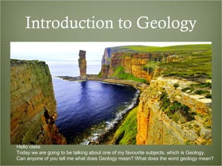
1. Introduction to Geology
Hello class
Today we are going to be talking about one of my favourite subjects, which is Geology.
Can anyone of you tell me what does Geology mean? What does the word geology mean?
2. What is geology?What is geology?
The best definition for the word geology that I can find is “the science that deals with the
Earth’s physical structure and substance, its history and the processes that act on it”
3. While talking about Geology, it’s best to start from the inside of the Earth and work our way out.
There are many different layers of the Earth so we are going to watch this short little video that
talks about the different layers inside of the Earth https://www.youtube.com/watch?v=OTJc2v7q-3Y
4. What are the two types
of crust?
Is the mantle solid or
liquid?
What is the core made
out of?
What is the largest part
of the earth?
So, after watching that wonderful video that gave you a nice introduction to the different layers
of the Earth. We are going now to answer few questions regarding the information.
The first question: What are the two types of crusts?
The second question: Is the Mantle solid or Liquid?
The third question: What is the core made out of?
And, finally, the fourth question: What is the largest layer within the Earth?
5. What are the two types of crust?
The first question, what are the two types of crust. Well, there are two types of crust and they
are called continental crust and oceanic crust. The continental crust is a granitic crust which
has a low density; whereas the oceanic crust is more basaltic and has a higher density.
6. Is the mantle solid or liquid?
The second question: Is the mantle solid or liquid?
Well, this is actually a trick question because it kind of behaves a little bit as both. The mantle
behave is a viscous liquid it means it’s composed of a plastic flowing rock
7. What is the core made out of?
For the third question: What is the core made out of?
This is another little bit trick question because the core consists of two different parts: the
inner core and the outer core. The inner core is a solid and it is composed of iron and nickel;
however, the outer core is more of a liquid
8. What is the largest part of the earth?
The final question, what is the largest part of the Earth?
Out of the different layers of the earth, the mantle occupies the most space
9. Plate
Tectonics
So, now we are going to talk a
little bit about plate tectonics.
Plate tectonics occurs on the top
layer of the earth, the crust. Plate
tectonics are fragmenting pieces
of the crust; that kind of move float
around the top layer of the earth
10. Plate Tectonics
Looking at this map of plate tectonics. Can you tell me which plate do you guys live on?
Which plate is Spain on?
11. Plate Tectonics
Of course, looking at this map, we can tell that Spain is on the Eurasian plate. This plate
consists of both continental crust ad oceanic crust.
12. Pangea
As I mentioned earlier,
the plates are
constantly in motion.
They move very little
but they are constantly
moving. Each year the
plates separate or come
together about the
distance how your finger
nail grows each year.
It’s a very short distance
but over millions and
millions of years it
makes up a very large
distance
13. Types of Plate Boundaries
Since the plates are constantly in motion, and they are all completely separate from each
other, there are boundaries that exist between the plates. There are three types of
boundaries that exist: the first one is called divergent boundaries, the second one is
convergent boundaries and the third one is transform boundaries
14. Divergent
Boundaries
Let’s now talk about divergent
boundaries. Divergent
boundaries are where two
plates are spreading apart.
They are separating from each
other. At the point where these
two plates are separating, there
is often a Rift or a Ridge that it
is created. There is also a lot of
volcanic activity in these zones,
A great example is the Mid
Atlantic Ridge and Iceland. You
can see where the plates have
separated and volcanic activity
has occurred and, eventually,
created an island.
15. Convergent
Boundaries
The second type of boundaries is convergent boundaries. This occurs where two plates are
coming together. When two plates come together, there is usually a subduction zone that is
created. This is when one plate goes underneath the other one. These create tranches
usually, like the Mariana Trench in the Pacific Ocean. Also in these spots there is a lot of
volcanic activity that is involved. You can see this, for example,where the Pacific plate and
the South American plate are coming together. We have an entire mountain range called the
Andes which have been created because of this convergent boundary
16. Transform
Boundaries
And finally, the third type of boundariesis transform boundaries. These are where two plates
are sliding against to each other. One of the main deference between this boundary and the
other two is there’s not typically volcanic activity involved, but there are a lot of earthquakes.
One great example of transform boundaries is the Saint Andres Fault, in North America
17. Mid Oceanic Ridge and Rift Valleys
This geologic activity occurs where there is a divergent boundary. These formations happen
where the earth’s crust is pulling apart. The two best examples of these formations are the
Mid-Atlantic Ridge and the East African Rift. The Mid-Atlantic Ridge is where the North and
South American plates are separating from the Eurasian and African plates. The East African
Rift is an active continental rift zone in Africa. The African plate is splitting into two new plates
and will create a new oceanic basin.
18. Trenches
This geologic formation occurs where there is a convergent boundary. These occur at
subduction zones where one tectonic plate is going under another tectonic plate. This
geologic activity forms a trench. The most famous trench is the Mariana Trench in the
Pacific Ocean where the Pacific plate is going under the Mariana plate. This is the
deepest point in all of the oceans on earth
19. Transform Boundaries
Unlike divergent and convergent boundaries, no land is formed nor lost with this type of
boundary. This is where two plates slide past each other horizontally. The most famous
example on a transform boundary on land is the San Andreas Fault in the western United
States. This occurs where the Pacific plate is sliding past the North American plate
20. Volcanoes
Volcanoes are a point on the earth’s surface where magma escapes from within the earth to
the earth’s surface. These often occur on divergent and convergent plate boundaries, but
they can also occur on Hot Spots.
There are six types of volcanoes. They are: fissure volcanoes, shield volcanoes, dome
volcanoes, ash-cinder volcanoes, composite volcanoes, and caldera volcano.
21. Fissure volcanoes
Fissure volcanoes are basically a crack in the earths core where the magma escapes.
Many examples of this type of volcano can be found in Iceland.
22. Shield volcanoes
Shield Volcanoes are volcanoes that typically do not have very violent eruptions and
form with a very gentle slope. The best example of this type of volcano is the Hawaiian
Islands.
23. Dome volcanoes
Dome volcanoes are formed by slow eruptions with slow moving lava. These have steep
slopes from the cooling lava.
25. Composite volcanoes
Composite volcanoes are usually tall mountainous volcanoes with violent eruptions.
Some famous examples of this type of volcano are Mount Fuji in Japan or Mount Vesuvius in
Italy.
26. Caldera volcanoes
Finally Caldera volcanoes are formed after a previous volcano has erupted and the
surround land has collapsed into the magma chamber of the original volcano. These
volcanoes usually have a very destructive eruption as well.
27. Hot Spots-Canary Islands
These are geologic regions of weak crusts with extra hot mantle underneath. They form
magma in plumes which rise to the earth’s surface and create volcanoes. These volcanoes
do not occur on plate boundaries. Some of the most famous hotspots are Yellowstone in the
United States and the Canary Islands in Spain.
28. Earthquakes
An earthquake is the violent shaking of the earth’s surface resulting from movement on the
earth’s crust. Earthquakes often occur on tectonic plate boundaries, but it is possible that
they can be caused by humans too. Earthquakes are measured on a seismic scale from 1-no
limit. However, the strongest recorded earthquake was a 9.5 in Chile.
29. Types of Faults
Faults are fractures in the earth’s surface which cause earthquakes when there is a large
movement. There are three types of faults that cause earthquakes. These are called normal
faults, thrust faults, and strike-slip faults. In this image you can see how the different types of
faults operate.
30. Ring of Fire
The Ring of Fire is located around the Pacific Ocean where a large amount of volcanic and
earthquake activity occurs.
More than 75% of volcanoes and 90% of earthquakes happen in the Ring of Fire.
The worst earthquake ever measured was in this area as well..
31. Earthquakes and Volcanoes in Spain
Volcanoes
Earthquakes
Even though Spain is located far from the Ring of Fire, it still has some earthquakes and
volcanoes. Most of the volcanoes and earthquakes occur in the Canary Islands due to its
location above a Hot Spot. The mainland has very little seismic activity and no volcanic
activity.
32. Types of rocks
Now I am going to tell you about the different types of rocks. There are three different types
of rocks and each type has a different origin. The types of rocks are: sedimentary, igneous,
and metamorphic
33. Sedimentary Rocks
These are the most common types of rocks that you can see on the earth’s surface but
actually only make up a small portion of the crust. They are made up of particles of sand,
clay, and sea creatures that have accumulated in low lying areas on the earth’s surface and
in bodies of water. The different materials are then cemented together. Typical types of
sedimentary rocks are sandstone and limestone
34. Igneous Rocks
This type of rock is created by the cooling of magma or lava. If this occurs on the earth’s
surface, it is called extrusive. If it cools within the earth, it is called intrusive. The most
popular types of igneous rocks are granite and basalt
35. Metamorphic Rocks
Finally, the last type of rocks is called metamorphic rocks. These rocks exist from the
transformation of existing rocks through intense heat and pressure. This causes a change in
the physical and chemical makeup of the rock. Slate and Marble are both examples of
metamorphic rocks
36. Rock Cycle
Now I will briefly tell you about the rock cycle. This diagram shows how each type of
rock is changed based on a series of factors like weathering, heat, and pressure. This shows
how each type of rock is related to the other and how processes change from one type to
another over time.
37. What is erosion?What is erosion?
Erosion is defined as removal of rocks and soil by wind, water, ice and gravity.
Wind, water, ice and gravity are also known as the agents of erosion. Now let’s take a look at
erosion a little more closely
38. Difference Between Weathering,
Erosion and Deposition
BREAKS
TAKES
MAKES
Weathering breaks down earth´s surface into sediment. BREAKS
Erosion is when sediments are transported. TAKES
Deposition is when sediment is dropped by whatever is carrying them sometimes creating
new formations. MAKES
39. Water Erosion
Rain
Rivers/Lakes/Oceans
This type of erosion can be caused by rain, rivers, lakes, oceans, and even floods. Dramatic
coastlines with cliffs and grottos are caused by oceans. Deep river valleys and canyons are
caused by rivers. The Grand Canyon was formed by water erosion
40. Ice Erosion
This is caused by glaciers. The glaciers pick up rocks and drag them along the ground under
intense pressure. It acts very much like sandpaper on the earth’s surface. It creates large U
shaped valleys and even glacial lake basins like the Great Lakes
41. Wind Erosion
There are two types of wind erosion. The first example is when the wind picks up pieces of
sand, carries them away and eventually deposits them in a different location. The second is
the effect the blowing sand has on anything it comes in contact with
42. Online Activity
Whats on Earth made this?
Now we are going to do a little activity. We are going to look at pictures of different rock
formations and determine what type of erosion took place