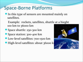
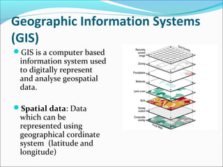
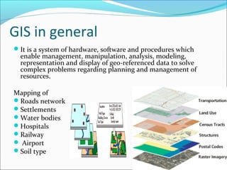
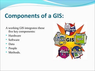
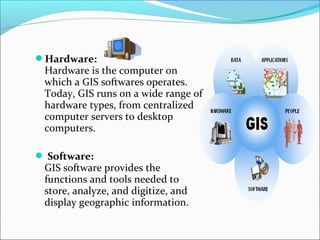
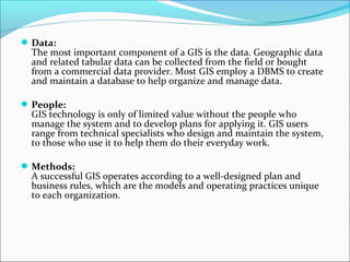
By-
Adarsh P Cherugad
Lecturer
Department of
Geoinformatics
Mangalore University
Mangalagangotri
-574199
What Is Geoinformatics:
Geoinformatics is the science and the technology
which develops and uses information science,
infrastructure to address the problems of geography,
geosciences and related branches of engineering.
“The art, science or technology dealing with the
acquisition, storage, processing, production,
presentation and dissemination of geoinformation“
Branches of geoinformatics
include:
1. Remote Sensing
2. Geographic Information Systems (GIS)
3. Cartography
4. Global Navigation Satellite Systems
5. Photogrammetry
6. DBMS- Data Base Management System
Remote Sensing:
Remote sensing is the acquisition of information about
an object or phenomenon without making physical
contact with the object.
Remote sensing is the technique of deriving information
about objects on the surface of the earth without
physically coming into contact with them. This process
involves making observations using sensors mounted on
platforms (aircraft and satellites), which are at a
considerable height from the earth surface and recording
the observations on a suitable medium.
Types of Remote Sensing
Passive Remote Sensing
Active Remote Sensing
Sensor:
Sensor is a device that measures and records
electromagnetic energy.
Types of sensors,
1. Passive sensors:
2.Active sensors:
Passive Remote Sensing
Passive remote sensing use reflected
or emitted electromagnetic energy
from the natural sources like sun. The
passive remote sensing system mainly
depending on the solar radiations.
 The Remote sensing system that uses
electromagnetic energy are called
Electromagnetic or Passive remote
sensing.
Examples:
Passive microwave radiometer
Active Remote sensing:
Active Remote sensing are the sensors which
emit their own source of energy. An active
remote sensing system generates and uses its
own source of energy.
Examples:
Lidar (LIght Detection And Ranging)
Radar (RAdio Detection And Ranging)
Falcon II LIDAR
REMOTE SENSING PLATFORMS
Platform is a stage to mount the camera or sensor to
acquire the information about a target under
investigation. Based on its altitude above earth
surface, platforms may be classified as
 Ground borne Platforms
 Air borne Platforms
 Space borne Platforms
Ground Based Platforms
Sensors are mounted on ground based
platforms.
Example: ground vehicles and towers.
Air Borne Platforms
In this type of sensors are mounted on air based
platforms.
Aircrafts are generally used to acquire aerial
photographs for photo-interpretation and
photogrammetric purposes.
Example: airplanes, helicopters, high-altitude
aircrafts, balloons.
Beechcraft KING AIR
C90
Space-Borne Platforms
In this type of sensors are mounted mainly on
satellites.
Example: rockets, satellites, shuttle at a hieght
100 km to 36000 km
Space shuttle: 250-300 km
Space station: 300-400 km
Low-level satellites: 700-1500 km
High-level satellites: about 36000 km
Depending on their altitudes and orbit these
platforms may be divided in two categories:
Geostationary
 Polar orbiting or Sun-synchronous
Polar satellites:
Polar orbiting satellites, whose orbits are in the
plane of the Earth’s polar axis.
Orbit of Polar orbiting satellites:
Equatorial satellites:
Equatorial orbiting satellites, whose orbits are
within the plane of the Equator.
Orbit of equatorial orbiting satellites:
Sun synchronous satellites:
An earth satellite orbit in which the
orbital plane is near polar and the
altitude is such that the satellite
passes over all places on earth
having the same latitude twice in
each orbit at the same local sun-
time.These satellites orbit at a
altitude betweeen 700 to 800 km.
These satellites the entire globe is
covered on regular basis and gives
repetitive coverage on periodic
basis.
Few of these satellites are Landsat
series, SPOT series, IRS series,
NOAA, SEASAT, TIROS etc.
Geosynchronous satellites:
Geostationary satellites are
“fixed” above a given point on the
Earth surface because their
circular orbits above the equator
have rotation period equals to the
earth’s rotation period.
An equatorial west to east satellite
orbiting the earth at an altitude of
36000 km. The altitude at which it
makes one revolution in 24 hours,
synchronous with earth's rotation.
Geosynchronous satellite:
These platforms are covering the same place and give
continuous coverage over the same area day and
night.
These are mainly used for communication and
meteorological applications.
Eg: GEOS, METOSAT, INTELSAT and INSAT
satellites
Geographic Information Systems
(GIS)
GIS is a computer based
information system used
to digitally represent
and analyse geospatial
data.
Spatial data: Data
which can be
represented using
geographical cordinate
system (latitude and
longitude)
Defination of GIS
A geographic information system (GIS) is a computer-based
system for the storage, retrieval, manipulation, analysis, and
display of geographic data.
Computer-based system refers to the hardware, software,
and procedures necessary to operate the GIS.
Geographic data are data which vary over geographical area.
Storage, retrieval, manipulation, analysis, and display are the
“tools” provided by GIS software for processing geographic
data.
GIS in general
It is a system of hardware, software and procedures which
enable management, manipulation, analysis, modeling,
representation and display of geo-referenced data to solve
complex problems regarding planning and management of
resources.
Mapping of
Roads network
Settlements
Water bodies
Hospitals
Railway
 Airport
Soil type
Components of a GIS:
A working GIS integrates these
five key components:
 Hardware
 Software
 Data
 People
 Methods.
Hardware:
Hardware is the computer on
which a GIS softwares operates.
Today, GIS runs on a wide range of
hardware types, from centralized
computer servers to desktop
computers.
 Software:
GIS software provides the
functions and tools needed to
store, analyze, and digitize, and
display geographic information.
Data:
The most important component of a GIS is the data. Geographic data
and related tabular data can be collected from the field or bought
from a commercial data provider. Most GIS employ a DBMS to create
and maintain a database to help organize and manage data.
People:
GIS technology is only of limited value without the people who
manage the system and to develop plans for applying it. GIS users
range from technical specialists who design and maintain the system,
to those who use it to help them do their everyday work.
Methods:
A successful GIS operates according to a well-designed plan and
business rules, which are the models and operating practices unique
to each organization.
Cartography:
Art,science or technology that deals with making
maps.
Global Navigation Systems
Global Navigation Systems:
The Global Positioning System (GPS) is a space-
based satellite navigation system that provides
location and time information in all weather
conditions, anywhere on or near the Earth where
there is an unobstructed line of sight to four or more
GPS satellites
Global Positioning satellite System (GPS)
Photogrammetry:
Photogrammetry is the art and science of
making accurate measurements and obtaining
reliable information by means of aerial
photography.
aerial survey
DBMS- Data Base Management
System
DBMS is a software designed to assist in
maintaining and utilizing large collection
of data.
Example: Oracle, SQL
Thank you

Geoinformatics

  • 1.
    By- Adarsh P Cherugad Lecturer Departmentof Geoinformatics Mangalore University Mangalagangotri -574199
  • 2.
    What Is Geoinformatics: Geoinformaticsis the science and the technology which develops and uses information science, infrastructure to address the problems of geography, geosciences and related branches of engineering. “The art, science or technology dealing with the acquisition, storage, processing, production, presentation and dissemination of geoinformation“
  • 3.
    Branches of geoinformatics include: 1.Remote Sensing 2. Geographic Information Systems (GIS) 3. Cartography 4. Global Navigation Satellite Systems 5. Photogrammetry 6. DBMS- Data Base Management System
  • 4.
    Remote Sensing: Remote sensingis the acquisition of information about an object or phenomenon without making physical contact with the object. Remote sensing is the technique of deriving information about objects on the surface of the earth without physically coming into contact with them. This process involves making observations using sensors mounted on platforms (aircraft and satellites), which are at a considerable height from the earth surface and recording the observations on a suitable medium.
  • 5.
    Types of RemoteSensing Passive Remote Sensing Active Remote Sensing
  • 6.
    Sensor: Sensor is adevice that measures and records electromagnetic energy. Types of sensors, 1. Passive sensors: 2.Active sensors:
  • 7.
    Passive Remote Sensing Passiveremote sensing use reflected or emitted electromagnetic energy from the natural sources like sun. The passive remote sensing system mainly depending on the solar radiations.  The Remote sensing system that uses electromagnetic energy are called Electromagnetic or Passive remote sensing. Examples: Passive microwave radiometer
  • 8.
    Active Remote sensing: ActiveRemote sensing are the sensors which emit their own source of energy. An active remote sensing system generates and uses its own source of energy. Examples: Lidar (LIght Detection And Ranging) Radar (RAdio Detection And Ranging) Falcon II LIDAR
  • 9.
    REMOTE SENSING PLATFORMS Platformis a stage to mount the camera or sensor to acquire the information about a target under investigation. Based on its altitude above earth surface, platforms may be classified as  Ground borne Platforms  Air borne Platforms  Space borne Platforms
  • 10.
    Ground Based Platforms Sensorsare mounted on ground based platforms. Example: ground vehicles and towers.
  • 11.
    Air Borne Platforms Inthis type of sensors are mounted on air based platforms. Aircrafts are generally used to acquire aerial photographs for photo-interpretation and photogrammetric purposes. Example: airplanes, helicopters, high-altitude aircrafts, balloons. Beechcraft KING AIR C90
  • 12.
    Space-Borne Platforms In thistype of sensors are mounted mainly on satellites. Example: rockets, satellites, shuttle at a hieght 100 km to 36000 km Space shuttle: 250-300 km Space station: 300-400 km Low-level satellites: 700-1500 km High-level satellites: about 36000 km
  • 13.
    Depending on theiraltitudes and orbit these platforms may be divided in two categories: Geostationary  Polar orbiting or Sun-synchronous
  • 14.
    Polar satellites: Polar orbitingsatellites, whose orbits are in the plane of the Earth’s polar axis. Orbit of Polar orbiting satellites:
  • 15.
    Equatorial satellites: Equatorial orbitingsatellites, whose orbits are within the plane of the Equator. Orbit of equatorial orbiting satellites:
  • 16.
    Sun synchronous satellites: Anearth satellite orbit in which the orbital plane is near polar and the altitude is such that the satellite passes over all places on earth having the same latitude twice in each orbit at the same local sun- time.These satellites orbit at a altitude betweeen 700 to 800 km. These satellites the entire globe is covered on regular basis and gives repetitive coverage on periodic basis. Few of these satellites are Landsat series, SPOT series, IRS series, NOAA, SEASAT, TIROS etc.
  • 17.
    Geosynchronous satellites: Geostationary satellitesare “fixed” above a given point on the Earth surface because their circular orbits above the equator have rotation period equals to the earth’s rotation period. An equatorial west to east satellite orbiting the earth at an altitude of 36000 km. The altitude at which it makes one revolution in 24 hours, synchronous with earth's rotation. Geosynchronous satellite:
  • 18.
    These platforms arecovering the same place and give continuous coverage over the same area day and night. These are mainly used for communication and meteorological applications. Eg: GEOS, METOSAT, INTELSAT and INSAT satellites
  • 19.
    Geographic Information Systems (GIS) GISis a computer based information system used to digitally represent and analyse geospatial data. Spatial data: Data which can be represented using geographical cordinate system (latitude and longitude)
  • 20.
    Defination of GIS Ageographic information system (GIS) is a computer-based system for the storage, retrieval, manipulation, analysis, and display of geographic data. Computer-based system refers to the hardware, software, and procedures necessary to operate the GIS. Geographic data are data which vary over geographical area. Storage, retrieval, manipulation, analysis, and display are the “tools” provided by GIS software for processing geographic data.
  • 21.
    GIS in general Itis a system of hardware, software and procedures which enable management, manipulation, analysis, modeling, representation and display of geo-referenced data to solve complex problems regarding planning and management of resources. Mapping of Roads network Settlements Water bodies Hospitals Railway  Airport Soil type
  • 22.
    Components of aGIS: A working GIS integrates these five key components:  Hardware  Software  Data  People  Methods.
  • 23.
    Hardware: Hardware is thecomputer on which a GIS softwares operates. Today, GIS runs on a wide range of hardware types, from centralized computer servers to desktop computers.  Software: GIS software provides the functions and tools needed to store, analyze, and digitize, and display geographic information.
  • 24.
    Data: The most importantcomponent of a GIS is the data. Geographic data and related tabular data can be collected from the field or bought from a commercial data provider. Most GIS employ a DBMS to create and maintain a database to help organize and manage data. People: GIS technology is only of limited value without the people who manage the system and to develop plans for applying it. GIS users range from technical specialists who design and maintain the system, to those who use it to help them do their everyday work. Methods: A successful GIS operates according to a well-designed plan and business rules, which are the models and operating practices unique to each organization.
  • 25.
    Cartography: Art,science or technologythat deals with making maps.
  • 26.
  • 27.
    Global Navigation Systems: TheGlobal Positioning System (GPS) is a space- based satellite navigation system that provides location and time information in all weather conditions, anywhere on or near the Earth where there is an unobstructed line of sight to four or more GPS satellites Global Positioning satellite System (GPS)
  • 28.
    Photogrammetry: Photogrammetry is theart and science of making accurate measurements and obtaining reliable information by means of aerial photography. aerial survey
  • 29.
    DBMS- Data BaseManagement System DBMS is a software designed to assist in maintaining and utilizing large collection of data. Example: Oracle, SQL
  • 30.