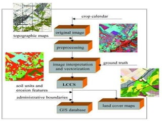
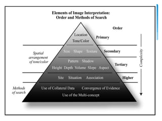
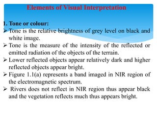
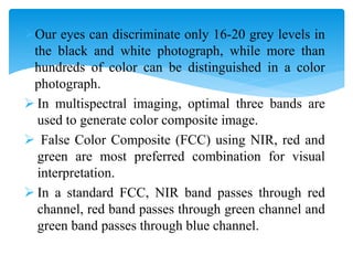
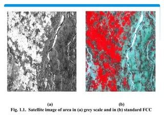
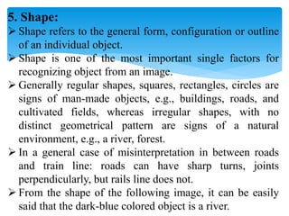
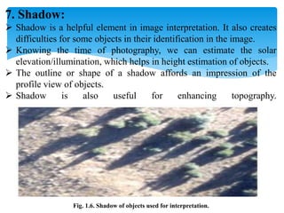
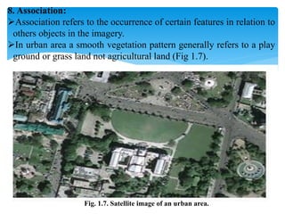
SlideShare a Scribd company logo
IMAGE PROCESSING
&
INTERPRETATION
By,
Prof. Shivaji R. Suryavanshi
Asst. Professor of Agronomy,
Dr. D.Y. Patil College of Agriculture, Talsande.
IMAGE INTERPRETATION
Aerial photographs as well as imagery, obtained by
remote sensing using aircraft or spacecraft as platforms,
have applicability in various fields.
Image interpretation is defined as the act of
examining images to identify objects and judge their
significance by considering their location.
An interpreter studies remotely sensed data and
attempts through logical process to detect, identify,
measure and evaluate the significance of environmental
and cultural objects, patterns and spatial relationships.
Elements of Visual Interpretation
1. Tone or colour:
 Tone is the relative brightness of grey level on black and
white image.
 Tone is the measure of the intensity of the reflected or
emitted radiation of the objects of the terrain.
 Lower reflected objects appear relatively dark and higher
reflected objects appear bright.
 Figure 1.1(a) represents a band imaged in NIR region of
the electromagnetic spectrum.
 Rivers does not reflect in NIR region thus appear black
and the vegetation reflects much thus appears bright.
Our eyes can discriminate only 16-20 grey levels in
the black and white photograph, while more than
hundreds of color can be distinguished in a color
photograph.
 In multispectral imaging, optimal three bands are
used to generate color composite image.
 False Color Composite (FCC) using NIR, red and
green are most preferred combination for visual
interpretation.
 In a standard FCC, NIR band passes through red
channel, red band passes through green channel and
green band passes through blue channel.
(a) (b)
Fig. 1.1. Satellite image of area in (a) grey scale and in (b) standard FCC
2. Texture:
 Texture refers to the frequency of tonal variation in an image.
 Texture is produced by an aggregate unit of features which
may be too small to be clearly discerned individually on the
image.
 It depends on shape, size, pattern and shadow of terrain
features.
 Texture is always scale or resolution dependent.
 Same reflected objects may have difference in texture helps in
their identification.
 As an example in a high resolution image grassland and tree
crowns have similar tone, but grassland will have smooth
texture compared to tree.
 Smooth texture refers to less tonal variation and rough texture
refers to abrupt tonal variation in an imagery or photograph.
Fig. 1.2. High resolution image showing different textures.
3. Pattern:
 Pattern refers to the spatial arrangement of the objects. Objects
both natural and manmade have a pattern which aids in their
recognition.
 The repetition of certain general form or relationship in tones and
texture creates a pattern, which is characteristic of this element in
image interpretation.
 In the Fig. 1.3 it could be easily understood that at the left bottom
corner of the image, it is plantation, where the tress are nearly
equally spaced.
 Whereas at the upper right and bottom right corners show natural
vegetation
4. Size:
 Size of objects on images must be considered in the context of the
image scale or resolution.
 It is important to assess the size of a target relative to other objects
in the scene, as well as the absolute size, to aid in the
interpretation of that target.
 A quick approximation of target size can make direct
interpretation to an appropriate result more quickly.
 The most measured parameters are length, width, perimeter, area,
and occasionally volume.
 For example, if an interpreter had to distinguish zones of land use,
and had identified an area with a number of buildings in it, large
buildings such as factories or warehouses would suggest
commercial property, whereas small buildings would indicate
residential use.
Fig. 9.4. Satellite view of a part of a city
5. Shape:
 Shape refers to the general form, configuration or outline
of an individual object.
 Shape is one of the most important single factors for
recognizing object from an image.
 Generally regular shapes, squares, rectangles, circles are
signs of man-made objects, e.g., buildings, roads, and
cultivated fields, whereas irregular shapes, with no
distinct geometrical pattern are signs of a natural
environment, e.g., a river, forest.
 In a general case of misinterpretation in between roads
and train line: roads can have sharp turns, joints
perpendicularly, but rails line does not.
 From the shape of the following image, it can be easily
said that the dark-blue colored object is a river.
1.5. Satellite image of an area
7. Shadow:
 Shadow is a helpful element in image interpretation. It also creates
difficulties for some objects in their identification in the image.
 Knowing the time of photography, we can estimate the solar
elevation/illumination, which helps in height estimation of objects.
 The outline or shape of a shadow affords an impression of the
profile view of objects.
 Shadow is also useful for enhancing topography.
Fig. 1.6. Shadow of objects used for interpretation.
8. Association:
Association refers to the occurrence of certain features in relation to
others objects in the imagery.
In urban area a smooth vegetation pattern generally refers to a play
ground or grass land not agricultural land (Fig 1.7).
Fig. 1.7. Satellite image of an urban area.
8. Site:
 Site refers to topographic or geographic location.
 It is also an important element in image interpretation
when objects are not clearly identified using the
previous the elements.
 A very high reflectance feature in the Himalayan
valley may be snow or cloud, but in Kerala one cannot
say it as snow.
Generation of Thematic Maps:
An image interpretation map is usually
produced by transferring the interpreted information
to a base map which has been prepared in advance.
The requirements of the base map should be as
follows:
Proper map scale to enable appropriate
presentation of interpreted information.
Geographic coordinate system to establish the
geographic reference.
 Basic map information to be printed in light tones
as background which results in enhancement of
interpreted information
Normally, a topographic map (Toposheet), plan
map, or ortho photomap is used as a base map.
Factors Governing the Quality of an image
In addition to the inherent characteristics of an object
itself, the following factors influence image quality:
 Sensor characteristics (film types, digital systems)
 Season of the year and time of day
 Atmospheric effects
 Resolution of the imaging system and scale
 Image motion
63

More Related Content

What's hot

Application of Remote Sensing in Agriculture
Application of Remote Sensing in AgricultureApplication of Remote Sensing in Agriculture
Application of Remote Sensing in Agriculture
UTTAM KUMAR
 
Weather forecasting in india
Weather forecasting in india Weather forecasting in india
Weather forecasting in india
Akarsh3083
 
COOLING AND HEATING OF GREENHOUSE
COOLING AND HEATING OF GREENHOUSECOOLING AND HEATING OF GREENHOUSE
COOLING AND HEATING OF GREENHOUSE
pramodrai30
 
Precision farming rohit pandey
Precision farming rohit pandeyPrecision farming rohit pandey
Precision farming rohit pandey
Govardhan Lodha
 
GIS and Remote Sensing in Diagnosis and Management of Problem Soil with audio...
GIS and Remote Sensing in Diagnosis and Management of Problem Soil with audio...GIS and Remote Sensing in Diagnosis and Management of Problem Soil with audio...
GIS and Remote Sensing in Diagnosis and Management of Problem Soil with audio...
KaminiKumari13
 
Remote sensing in agriculture
Remote sensing in agricultureRemote sensing in agriculture
Remote sensing in agriculture
Chitra Nair
 
Geographic information system (GIS) and its application in precision farming
Geographic information system (GIS) and its application in precision farmingGeographic information system (GIS) and its application in precision farming
Geographic information system (GIS) and its application in precision farming
Dr. M. Kumaresan Hort.
 
Flooded Soils
Flooded SoilsFlooded Soils
Flooded Soils
Risikesh Thakur
 
Application of remote sensing in precision farming
 Application of remote sensing in precision farming  Application of remote sensing in precision farming
Application of remote sensing in precision farming
Suman Dey
 
role of Geospatial technology in agriculture
role of Geospatial technology  in agriculturerole of Geospatial technology  in agriculture
role of Geospatial technology in agriculture
Dr. MADHO SINGH
 
Agrometeorology
AgrometeorologyAgrometeorology
Agrometeorology
SandeepSingh2324
 
Scope and importance, principles and concepts of precision horticulture
Scope and importance, principles and concepts of precision horticulture Scope and importance, principles and concepts of precision horticulture
Scope and importance, principles and concepts of precision horticulture
Dr. M. Kumaresan Hort.
 
Land capability classification
Land  capability classificationLand  capability classification
Land capability classification
ShaheenPraveen1
 
remote sensing in agriculture
remote sensing in agricultureremote sensing in agriculture
remote sensing in agriculture
veerendra manduri
 
Site Specific nutrient Management for Precision Agriculture - Anjali Patel (I...
Site Specific nutrient Management for Precision Agriculture - Anjali Patel (I...Site Specific nutrient Management for Precision Agriculture - Anjali Patel (I...
Site Specific nutrient Management for Precision Agriculture - Anjali Patel (I...
Rahul Raj Tandon
 
Objectives on Geoinformatics and Nanotechnology and Precision Farming
Objectives on Geoinformatics and Nanotechnology and Precision FarmingObjectives on Geoinformatics and Nanotechnology and Precision Farming
Objectives on Geoinformatics and Nanotechnology and Precision Farming
SHIVAJI SURYAVANSHI
 
Agro-Ecological Regions of India
Agro-Ecological Regions of IndiaAgro-Ecological Regions of India
Agro-Ecological Regions of India
Calcutta University
 
L12-Soil-Test-Crop-Response-PPT.pdf
L12-Soil-Test-Crop-Response-PPT.pdfL12-Soil-Test-Crop-Response-PPT.pdf
L12-Soil-Test-Crop-Response-PPT.pdf
SayyedAadil1
 
Precision Farming by Dr. Pooja Goswami
Precision Farming by Dr. Pooja GoswamiPrecision Farming by Dr. Pooja Goswami
Precision Farming by Dr. Pooja Goswami
College of Agriculture, Balaghat
 
DRYLAND FARMING
DRYLAND FARMING DRYLAND FARMING
DRYLAND FARMING
Pramod Kumar Tiwari
 

What's hot (20)

Application of Remote Sensing in Agriculture
Application of Remote Sensing in AgricultureApplication of Remote Sensing in Agriculture
Application of Remote Sensing in Agriculture
 
Weather forecasting in india
Weather forecasting in india Weather forecasting in india
Weather forecasting in india
 
COOLING AND HEATING OF GREENHOUSE
COOLING AND HEATING OF GREENHOUSECOOLING AND HEATING OF GREENHOUSE
COOLING AND HEATING OF GREENHOUSE
 
Precision farming rohit pandey
Precision farming rohit pandeyPrecision farming rohit pandey
Precision farming rohit pandey
 
GIS and Remote Sensing in Diagnosis and Management of Problem Soil with audio...
GIS and Remote Sensing in Diagnosis and Management of Problem Soil with audio...GIS and Remote Sensing in Diagnosis and Management of Problem Soil with audio...
GIS and Remote Sensing in Diagnosis and Management of Problem Soil with audio...
 
Remote sensing in agriculture
Remote sensing in agricultureRemote sensing in agriculture
Remote sensing in agriculture
 
Geographic information system (GIS) and its application in precision farming
Geographic information system (GIS) and its application in precision farmingGeographic information system (GIS) and its application in precision farming
Geographic information system (GIS) and its application in precision farming
 
Flooded Soils
Flooded SoilsFlooded Soils
Flooded Soils
 
Application of remote sensing in precision farming
 Application of remote sensing in precision farming  Application of remote sensing in precision farming
Application of remote sensing in precision farming
 
role of Geospatial technology in agriculture
role of Geospatial technology  in agriculturerole of Geospatial technology  in agriculture
role of Geospatial technology in agriculture
 
Agrometeorology
AgrometeorologyAgrometeorology
Agrometeorology
 
Scope and importance, principles and concepts of precision horticulture
Scope and importance, principles and concepts of precision horticulture Scope and importance, principles and concepts of precision horticulture
Scope and importance, principles and concepts of precision horticulture
 
Land capability classification
Land  capability classificationLand  capability classification
Land capability classification
 
remote sensing in agriculture
remote sensing in agricultureremote sensing in agriculture
remote sensing in agriculture
 
Site Specific nutrient Management for Precision Agriculture - Anjali Patel (I...
Site Specific nutrient Management for Precision Agriculture - Anjali Patel (I...Site Specific nutrient Management for Precision Agriculture - Anjali Patel (I...
Site Specific nutrient Management for Precision Agriculture - Anjali Patel (I...
 
Objectives on Geoinformatics and Nanotechnology and Precision Farming
Objectives on Geoinformatics and Nanotechnology and Precision FarmingObjectives on Geoinformatics and Nanotechnology and Precision Farming
Objectives on Geoinformatics and Nanotechnology and Precision Farming
 
Agro-Ecological Regions of India
Agro-Ecological Regions of IndiaAgro-Ecological Regions of India
Agro-Ecological Regions of India
 
L12-Soil-Test-Crop-Response-PPT.pdf
L12-Soil-Test-Crop-Response-PPT.pdfL12-Soil-Test-Crop-Response-PPT.pdf
L12-Soil-Test-Crop-Response-PPT.pdf
 
Precision Farming by Dr. Pooja Goswami
Precision Farming by Dr. Pooja GoswamiPrecision Farming by Dr. Pooja Goswami
Precision Farming by Dr. Pooja Goswami
 
DRYLAND FARMING
DRYLAND FARMING DRYLAND FARMING
DRYLAND FARMING
 

Similar to Image processing & interpretation

Image interpretation keys & image resolution
Image interpretation keys & image resolutionImage interpretation keys & image resolution
Image interpretation keys & image resolution
Pramoda Raj
 
Application of remote sensing in agriculture
Application of remote sensing in agricultureApplication of remote sensing in agriculture
Application of remote sensing in agriculture
vajinder kalra
 
IMAGE INTERPRETATION TECHNIQUES of survey
IMAGE INTERPRETATION TECHNIQUES of surveyIMAGE INTERPRETATION TECHNIQUES of survey
IMAGE INTERPRETATION TECHNIQUES of survey
Karan Patel
 
Unit I - Introduction to Maps.pptx
Unit I - Introduction to Maps.pptxUnit I - Introduction to Maps.pptx
Unit I - Introduction to Maps.pptx
DrVenkateswarluGogan1
 
The application of remote sensing technique to verify changes in landscape du...
The application of remote sensing technique to verify changes in landscape du...The application of remote sensing technique to verify changes in landscape du...
The application of remote sensing technique to verify changes in landscape du...
Alexander Decker
 
Introduction to Maps
Introduction to MapsIntroduction to Maps
Introduction to Maps
Malla Reddy University
 
TYBSC IT PGIS Unit V Data Visualization
TYBSC IT PGIS Unit V  Data VisualizationTYBSC IT PGIS Unit V  Data Visualization
TYBSC IT PGIS Unit V Data Visualization
Arti Parab Academics
 
Image enhancement technique digital image analysis, in remote sensing ,P K MANI
Image enhancement technique  digital image analysis, in remote sensing ,P K MANIImage enhancement technique  digital image analysis, in remote sensing ,P K MANI
Image enhancement technique digital image analysis, in remote sensing ,P K MANI
P.K. Mani
 
Image analysis basics and principles
Image analysis basics and principlesImage analysis basics and principles
Image analysis basics and principles
Mohsin Siddique
 
WHAT IS IMAGE INTERPRETATION?
WHAT IS IMAGE INTERPRETATION?WHAT IS IMAGE INTERPRETATION?
WHAT IS IMAGE INTERPRETATION?
Spatial IT Solutions Pvt Ltd.
 
Chapter2 gis fundamentals
Chapter2 gis fundamentalsChapter2 gis fundamentals
Chapter2 gis fundamentals
mayasubodh22
 
Gupte - first year paper_approved (1)
Gupte - first year paper_approved (1)Gupte - first year paper_approved (1)
Gupte - first year paper_approved (1)
Shweta Gupte
 
Chapter 3 map basics
Chapter   3 map basicsChapter   3 map basics
Chapter 3 map basics
Ajay Ardeshana
 
Surreal analysis
Surreal analysisSurreal analysis
Surreal analysis
samtc98
 
Map reading
Map readingMap reading
Map reading
joffreyestrada
 
Exploring our geographic world by tessie calimag bb.
Exploring our geographic world by tessie calimag bb.Exploring our geographic world by tessie calimag bb.
Exploring our geographic world by tessie calimag bb.
Tessie Calimag
 
GIS-Chapter-11-Thematic-Mapping-Visualizing-Geographic-Data.pptx
GIS-Chapter-11-Thematic-Mapping-Visualizing-Geographic-Data.pptxGIS-Chapter-11-Thematic-Mapping-Visualizing-Geographic-Data.pptx
GIS-Chapter-11-Thematic-Mapping-Visualizing-Geographic-Data.pptx
MuhammadJazman1
 
Bt0077 multimedia systems
Bt0077 multimedia systemsBt0077 multimedia systems
Bt0077 multimedia systems
Techglyphs
 
Remote Sensing 1.3.docx
Remote Sensing 1.3.docxRemote Sensing 1.3.docx
Remote Sensing 1.3.docx
bharatsingh300
 
Fuzzy Region Merging Using Fuzzy Similarity Measurement on Image Segmentation
Fuzzy Region Merging Using Fuzzy Similarity Measurement  on Image Segmentation  Fuzzy Region Merging Using Fuzzy Similarity Measurement  on Image Segmentation
Fuzzy Region Merging Using Fuzzy Similarity Measurement on Image Segmentation
IJECEIAES
 

Similar to Image processing & interpretation (20)

Image interpretation keys & image resolution
Image interpretation keys & image resolutionImage interpretation keys & image resolution
Image interpretation keys & image resolution
 
Application of remote sensing in agriculture
Application of remote sensing in agricultureApplication of remote sensing in agriculture
Application of remote sensing in agriculture
 
IMAGE INTERPRETATION TECHNIQUES of survey
IMAGE INTERPRETATION TECHNIQUES of surveyIMAGE INTERPRETATION TECHNIQUES of survey
IMAGE INTERPRETATION TECHNIQUES of survey
 
Unit I - Introduction to Maps.pptx
Unit I - Introduction to Maps.pptxUnit I - Introduction to Maps.pptx
Unit I - Introduction to Maps.pptx
 
The application of remote sensing technique to verify changes in landscape du...
The application of remote sensing technique to verify changes in landscape du...The application of remote sensing technique to verify changes in landscape du...
The application of remote sensing technique to verify changes in landscape du...
 
Introduction to Maps
Introduction to MapsIntroduction to Maps
Introduction to Maps
 
TYBSC IT PGIS Unit V Data Visualization
TYBSC IT PGIS Unit V  Data VisualizationTYBSC IT PGIS Unit V  Data Visualization
TYBSC IT PGIS Unit V Data Visualization
 
Image enhancement technique digital image analysis, in remote sensing ,P K MANI
Image enhancement technique  digital image analysis, in remote sensing ,P K MANIImage enhancement technique  digital image analysis, in remote sensing ,P K MANI
Image enhancement technique digital image analysis, in remote sensing ,P K MANI
 
Image analysis basics and principles
Image analysis basics and principlesImage analysis basics and principles
Image analysis basics and principles
 
WHAT IS IMAGE INTERPRETATION?
WHAT IS IMAGE INTERPRETATION?WHAT IS IMAGE INTERPRETATION?
WHAT IS IMAGE INTERPRETATION?
 
Chapter2 gis fundamentals
Chapter2 gis fundamentalsChapter2 gis fundamentals
Chapter2 gis fundamentals
 
Gupte - first year paper_approved (1)
Gupte - first year paper_approved (1)Gupte - first year paper_approved (1)
Gupte - first year paper_approved (1)
 
Chapter 3 map basics
Chapter   3 map basicsChapter   3 map basics
Chapter 3 map basics
 
Surreal analysis
Surreal analysisSurreal analysis
Surreal analysis
 
Map reading
Map readingMap reading
Map reading
 
Exploring our geographic world by tessie calimag bb.
Exploring our geographic world by tessie calimag bb.Exploring our geographic world by tessie calimag bb.
Exploring our geographic world by tessie calimag bb.
 
GIS-Chapter-11-Thematic-Mapping-Visualizing-Geographic-Data.pptx
GIS-Chapter-11-Thematic-Mapping-Visualizing-Geographic-Data.pptxGIS-Chapter-11-Thematic-Mapping-Visualizing-Geographic-Data.pptx
GIS-Chapter-11-Thematic-Mapping-Visualizing-Geographic-Data.pptx
 
Bt0077 multimedia systems
Bt0077 multimedia systemsBt0077 multimedia systems
Bt0077 multimedia systems
 
Remote Sensing 1.3.docx
Remote Sensing 1.3.docxRemote Sensing 1.3.docx
Remote Sensing 1.3.docx
 
Fuzzy Region Merging Using Fuzzy Similarity Measurement on Image Segmentation
Fuzzy Region Merging Using Fuzzy Similarity Measurement  on Image Segmentation  Fuzzy Region Merging Using Fuzzy Similarity Measurement  on Image Segmentation
Fuzzy Region Merging Using Fuzzy Similarity Measurement on Image Segmentation
 

More from SHIVAJI SURYAVANSHI

Horticultural crops information
Horticultural crops informationHorticultural crops information
Horticultural crops information
SHIVAJI SURYAVANSHI
 
RAINFED AGRICULTURE & WATERSHED MANAGEMENT
RAINFED AGRICULTURE & WATERSHED MANAGEMENTRAINFED AGRICULTURE & WATERSHED MANAGEMENT
RAINFED AGRICULTURE & WATERSHED MANAGEMENT
SHIVAJI SURYAVANSHI
 
Principles of Organic Farming theory notes (AGRO-248)
Principles of Organic Farming theory notes (AGRO-248)Principles of Organic Farming theory notes (AGRO-248)
Principles of Organic Farming theory notes (AGRO-248)
SHIVAJI SURYAVANSHI
 
Objectives on Farming System & Sustainable Agriculture
Objectives on Farming System & Sustainable AgricultureObjectives on Farming System & Sustainable Agriculture
Objectives on Farming System & Sustainable Agriculture
SHIVAJI SURYAVANSHI
 
Objectives on Fundamentals of Agronomy-II
Objectives on Fundamentals of Agronomy-IIObjectives on Fundamentals of Agronomy-II
Objectives on Fundamentals of Agronomy-II
SHIVAJI SURYAVANSHI
 
WOMEN IN AGRICULTURE: MULTIFACETED ROLES AND TASKS, WORK STRESS FACTORS, NUTR...
WOMEN IN AGRICULTURE: MULTIFACETED ROLES AND TASKS, WORK STRESS FACTORS, NUTR...WOMEN IN AGRICULTURE: MULTIFACETED ROLES AND TASKS, WORK STRESS FACTORS, NUTR...
WOMEN IN AGRICULTURE: MULTIFACETED ROLES AND TASKS, WORK STRESS FACTORS, NUTR...
SHIVAJI SURYAVANSHI
 
ROLE OF WOMEN IN HOUSEHOLD DECISION MAKING, DRUDGERY REDUCTION FOR FARM WOMEN...
ROLE OF WOMEN IN HOUSEHOLD DECISION MAKING, DRUDGERY REDUCTION FOR FARM WOMEN...ROLE OF WOMEN IN HOUSEHOLD DECISION MAKING, DRUDGERY REDUCTION FOR FARM WOMEN...
ROLE OF WOMEN IN HOUSEHOLD DECISION MAKING, DRUDGERY REDUCTION FOR FARM WOMEN...
SHIVAJI SURYAVANSHI
 
FACTORS AFFECTING CROP PRODUCTION
FACTORS AFFECTING CROP PRODUCTIONFACTORS AFFECTING CROP PRODUCTION
FACTORS AFFECTING CROP PRODUCTION
SHIVAJI SURYAVANSHI
 
HISTORY OF AGRICULTURAL DEVELOPMENT IN ANCIENT INDIA, AGRICULTURE IN CIVILIZA...
HISTORY OF AGRICULTURAL DEVELOPMENT IN ANCIENT INDIA, AGRICULTURE IN CIVILIZA...HISTORY OF AGRICULTURAL DEVELOPMENT IN ANCIENT INDIA, AGRICULTURE IN CIVILIZA...
HISTORY OF AGRICULTURAL DEVELOPMENT IN ANCIENT INDIA, AGRICULTURE IN CIVILIZA...
SHIVAJI SURYAVANSHI
 
AGRICULTURE, ITS HISTORY & SCOPE IN INDIA AND MAHARASHTRA
AGRICULTURE, ITS HISTORY & SCOPE IN INDIA AND MAHARASHTRAAGRICULTURE, ITS HISTORY & SCOPE IN INDIA AND MAHARASHTRA
AGRICULTURE, ITS HISTORY & SCOPE IN INDIA AND MAHARASHTRA
SHIVAJI SURYAVANSHI
 
SCOPE OF AGRICULTURE IN INDIA AND MAHARASHTRA
SCOPE OF AGRICULTURE IN INDIA AND MAHARASHTRASCOPE OF AGRICULTURE IN INDIA AND MAHARASHTRA
SCOPE OF AGRICULTURE IN INDIA AND MAHARASHTRA
SHIVAJI SURYAVANSHI
 
AGRICULTURE, ITS HISTORY & SCOPE IN INDIA AND MAHARASHTRA
AGRICULTURE, ITS HISTORY & SCOPE IN INDIA AND MAHARASHTRAAGRICULTURE, ITS HISTORY & SCOPE IN INDIA AND MAHARASHTRA
AGRICULTURE, ITS HISTORY & SCOPE IN INDIA AND MAHARASHTRA
SHIVAJI SURYAVANSHI
 
CROP PRODUCTION AND FACTORS AFFECTING IT
CROP PRODUCTION AND FACTORS AFFECTING ITCROP PRODUCTION AND FACTORS AFFECTING IT
CROP PRODUCTION AND FACTORS AFFECTING IT
SHIVAJI SURYAVANSHI
 
Movement of soil water
Movement of soil waterMovement of soil water
Movement of soil water
SHIVAJI SURYAVANSHI
 
Classification of soil water & soil moisture characteristics curve
Classification of soil water & soil moisture characteristics curveClassification of soil water & soil moisture characteristics curve
Classification of soil water & soil moisture characteristics curve
SHIVAJI SURYAVANSHI
 
Soil water plant relationship
Soil water plant relationshipSoil water plant relationship
Soil water plant relationship
SHIVAJI SURYAVANSHI
 
Irrigation
Irrigation Irrigation
Irrigation
SHIVAJI SURYAVANSHI
 
Classification of soil water
Classification of soil waterClassification of soil water
Classification of soil water
SHIVAJI SURYAVANSHI
 
Integrated disease management of cucurbitacious crops
Integrated disease management of cucurbitacious cropsIntegrated disease management of cucurbitacious crops
Integrated disease management of cucurbitacious crops
SHIVAJI SURYAVANSHI
 
Fym
FymFym

More from SHIVAJI SURYAVANSHI (20)

Horticultural crops information
Horticultural crops informationHorticultural crops information
Horticultural crops information
 
RAINFED AGRICULTURE & WATERSHED MANAGEMENT
RAINFED AGRICULTURE & WATERSHED MANAGEMENTRAINFED AGRICULTURE & WATERSHED MANAGEMENT
RAINFED AGRICULTURE & WATERSHED MANAGEMENT
 
Principles of Organic Farming theory notes (AGRO-248)
Principles of Organic Farming theory notes (AGRO-248)Principles of Organic Farming theory notes (AGRO-248)
Principles of Organic Farming theory notes (AGRO-248)
 
Objectives on Farming System & Sustainable Agriculture
Objectives on Farming System & Sustainable AgricultureObjectives on Farming System & Sustainable Agriculture
Objectives on Farming System & Sustainable Agriculture
 
Objectives on Fundamentals of Agronomy-II
Objectives on Fundamentals of Agronomy-IIObjectives on Fundamentals of Agronomy-II
Objectives on Fundamentals of Agronomy-II
 
WOMEN IN AGRICULTURE: MULTIFACETED ROLES AND TASKS, WORK STRESS FACTORS, NUTR...
WOMEN IN AGRICULTURE: MULTIFACETED ROLES AND TASKS, WORK STRESS FACTORS, NUTR...WOMEN IN AGRICULTURE: MULTIFACETED ROLES AND TASKS, WORK STRESS FACTORS, NUTR...
WOMEN IN AGRICULTURE: MULTIFACETED ROLES AND TASKS, WORK STRESS FACTORS, NUTR...
 
ROLE OF WOMEN IN HOUSEHOLD DECISION MAKING, DRUDGERY REDUCTION FOR FARM WOMEN...
ROLE OF WOMEN IN HOUSEHOLD DECISION MAKING, DRUDGERY REDUCTION FOR FARM WOMEN...ROLE OF WOMEN IN HOUSEHOLD DECISION MAKING, DRUDGERY REDUCTION FOR FARM WOMEN...
ROLE OF WOMEN IN HOUSEHOLD DECISION MAKING, DRUDGERY REDUCTION FOR FARM WOMEN...
 
FACTORS AFFECTING CROP PRODUCTION
FACTORS AFFECTING CROP PRODUCTIONFACTORS AFFECTING CROP PRODUCTION
FACTORS AFFECTING CROP PRODUCTION
 
HISTORY OF AGRICULTURAL DEVELOPMENT IN ANCIENT INDIA, AGRICULTURE IN CIVILIZA...
HISTORY OF AGRICULTURAL DEVELOPMENT IN ANCIENT INDIA, AGRICULTURE IN CIVILIZA...HISTORY OF AGRICULTURAL DEVELOPMENT IN ANCIENT INDIA, AGRICULTURE IN CIVILIZA...
HISTORY OF AGRICULTURAL DEVELOPMENT IN ANCIENT INDIA, AGRICULTURE IN CIVILIZA...
 
AGRICULTURE, ITS HISTORY & SCOPE IN INDIA AND MAHARASHTRA
AGRICULTURE, ITS HISTORY & SCOPE IN INDIA AND MAHARASHTRAAGRICULTURE, ITS HISTORY & SCOPE IN INDIA AND MAHARASHTRA
AGRICULTURE, ITS HISTORY & SCOPE IN INDIA AND MAHARASHTRA
 
SCOPE OF AGRICULTURE IN INDIA AND MAHARASHTRA
SCOPE OF AGRICULTURE IN INDIA AND MAHARASHTRASCOPE OF AGRICULTURE IN INDIA AND MAHARASHTRA
SCOPE OF AGRICULTURE IN INDIA AND MAHARASHTRA
 
AGRICULTURE, ITS HISTORY & SCOPE IN INDIA AND MAHARASHTRA
AGRICULTURE, ITS HISTORY & SCOPE IN INDIA AND MAHARASHTRAAGRICULTURE, ITS HISTORY & SCOPE IN INDIA AND MAHARASHTRA
AGRICULTURE, ITS HISTORY & SCOPE IN INDIA AND MAHARASHTRA
 
CROP PRODUCTION AND FACTORS AFFECTING IT
CROP PRODUCTION AND FACTORS AFFECTING ITCROP PRODUCTION AND FACTORS AFFECTING IT
CROP PRODUCTION AND FACTORS AFFECTING IT
 
Movement of soil water
Movement of soil waterMovement of soil water
Movement of soil water
 
Classification of soil water & soil moisture characteristics curve
Classification of soil water & soil moisture characteristics curveClassification of soil water & soil moisture characteristics curve
Classification of soil water & soil moisture characteristics curve
 
Soil water plant relationship
Soil water plant relationshipSoil water plant relationship
Soil water plant relationship
 
Irrigation
Irrigation Irrigation
Irrigation
 
Classification of soil water
Classification of soil waterClassification of soil water
Classification of soil water
 
Integrated disease management of cucurbitacious crops
Integrated disease management of cucurbitacious cropsIntegrated disease management of cucurbitacious crops
Integrated disease management of cucurbitacious crops
 
Fym
FymFym
Fym
 

Recently uploaded

Liberal Approach to the Study of Indian Politics.pdf
Liberal Approach to the Study of Indian Politics.pdfLiberal Approach to the Study of Indian Politics.pdf
Liberal Approach to the Study of Indian Politics.pdf
WaniBasim
 
PCOS corelations and management through Ayurveda.
PCOS corelations and management through Ayurveda.PCOS corelations and management through Ayurveda.
PCOS corelations and management through Ayurveda.
Dr. Shivangi Singh Parihar
 
Chapter 4 - Islamic Financial Institutions in Malaysia.pptx
Chapter 4 - Islamic Financial Institutions in Malaysia.pptxChapter 4 - Islamic Financial Institutions in Malaysia.pptx
Chapter 4 - Islamic Financial Institutions in Malaysia.pptx
Mohd Adib Abd Muin, Senior Lecturer at Universiti Utara Malaysia
 
How to Fix the Import Error in the Odoo 17
How to Fix the Import Error in the Odoo 17How to Fix the Import Error in the Odoo 17
How to Fix the Import Error in the Odoo 17
Celine George
 
How to Manage Your Lost Opportunities in Odoo 17 CRM
How to Manage Your Lost Opportunities in Odoo 17 CRMHow to Manage Your Lost Opportunities in Odoo 17 CRM
How to Manage Your Lost Opportunities in Odoo 17 CRM
Celine George
 
Community pharmacy- Social and preventive pharmacy UNIT 5
Community pharmacy- Social and preventive pharmacy UNIT 5Community pharmacy- Social and preventive pharmacy UNIT 5
Community pharmacy- Social and preventive pharmacy UNIT 5
sayalidalavi006
 
Film vocab for eal 3 students: Australia the movie
Film vocab for eal 3 students: Australia the movieFilm vocab for eal 3 students: Australia the movie
Film vocab for eal 3 students: Australia the movie
Nicholas Montgomery
 
Smart-Money for SMC traders good time and ICT
Smart-Money for SMC traders good time and ICTSmart-Money for SMC traders good time and ICT
Smart-Money for SMC traders good time and ICT
simonomuemu
 
Pollock and Snow "DEIA in the Scholarly Landscape, Session One: Setting Expec...
Pollock and Snow "DEIA in the Scholarly Landscape, Session One: Setting Expec...Pollock and Snow "DEIA in the Scholarly Landscape, Session One: Setting Expec...
Pollock and Snow "DEIA in the Scholarly Landscape, Session One: Setting Expec...
National Information Standards Organization (NISO)
 
Your Skill Boost Masterclass: Strategies for Effective Upskilling
Your Skill Boost Masterclass: Strategies for Effective UpskillingYour Skill Boost Masterclass: Strategies for Effective Upskilling
Your Skill Boost Masterclass: Strategies for Effective Upskilling
Excellence Foundation for South Sudan
 
PIMS Job Advertisement 2024.pdf Islamabad
PIMS Job Advertisement 2024.pdf IslamabadPIMS Job Advertisement 2024.pdf Islamabad
PIMS Job Advertisement 2024.pdf Islamabad
AyyanKhan40
 
C1 Rubenstein AP HuG xxxxxxxxxxxxxx.pptx
C1 Rubenstein AP HuG xxxxxxxxxxxxxx.pptxC1 Rubenstein AP HuG xxxxxxxxxxxxxx.pptx
C1 Rubenstein AP HuG xxxxxxxxxxxxxx.pptx
mulvey2
 
Hindi varnamala | hindi alphabet PPT.pdf
Hindi varnamala | hindi alphabet PPT.pdfHindi varnamala | hindi alphabet PPT.pdf
Hindi varnamala | hindi alphabet PPT.pdf
Dr. Mulla Adam Ali
 
World environment day ppt For 5 June 2024
World environment day ppt For 5 June 2024World environment day ppt For 5 June 2024
World environment day ppt For 5 June 2024
ak6969907
 
The simplified electron and muon model, Oscillating Spacetime: The Foundation...
The simplified electron and muon model, Oscillating Spacetime: The Foundation...The simplified electron and muon model, Oscillating Spacetime: The Foundation...
The simplified electron and muon model, Oscillating Spacetime: The Foundation...
RitikBhardwaj56
 
Main Java[All of the Base Concepts}.docx
Main Java[All of the Base Concepts}.docxMain Java[All of the Base Concepts}.docx
Main Java[All of the Base Concepts}.docx
adhitya5119
 
DRUGS AND ITS classification slide share
DRUGS AND ITS classification slide shareDRUGS AND ITS classification slide share
DRUGS AND ITS classification slide share
taiba qazi
 
বাংলাদেশ অর্থনৈতিক সমীক্ষা (Economic Review) ২০২৪ UJS App.pdf
বাংলাদেশ অর্থনৈতিক সমীক্ষা (Economic Review) ২০২৪ UJS App.pdfবাংলাদেশ অর্থনৈতিক সমীক্ষা (Economic Review) ২০২৪ UJS App.pdf
বাংলাদেশ অর্থনৈতিক সমীক্ষা (Economic Review) ২০২৪ UJS App.pdf
eBook.com.bd (প্রয়োজনীয় বাংলা বই)
 
Life upper-Intermediate B2 Workbook for student
Life upper-Intermediate B2 Workbook for studentLife upper-Intermediate B2 Workbook for student
Life upper-Intermediate B2 Workbook for student
NgcHiNguyn25
 
S1-Introduction-Biopesticides in ICM.pptx
S1-Introduction-Biopesticides in ICM.pptxS1-Introduction-Biopesticides in ICM.pptx
S1-Introduction-Biopesticides in ICM.pptx
tarandeep35
 

Recently uploaded (20)

Liberal Approach to the Study of Indian Politics.pdf
Liberal Approach to the Study of Indian Politics.pdfLiberal Approach to the Study of Indian Politics.pdf
Liberal Approach to the Study of Indian Politics.pdf
 
PCOS corelations and management through Ayurveda.
PCOS corelations and management through Ayurveda.PCOS corelations and management through Ayurveda.
PCOS corelations and management through Ayurveda.
 
Chapter 4 - Islamic Financial Institutions in Malaysia.pptx
Chapter 4 - Islamic Financial Institutions in Malaysia.pptxChapter 4 - Islamic Financial Institutions in Malaysia.pptx
Chapter 4 - Islamic Financial Institutions in Malaysia.pptx
 
How to Fix the Import Error in the Odoo 17
How to Fix the Import Error in the Odoo 17How to Fix the Import Error in the Odoo 17
How to Fix the Import Error in the Odoo 17
 
How to Manage Your Lost Opportunities in Odoo 17 CRM
How to Manage Your Lost Opportunities in Odoo 17 CRMHow to Manage Your Lost Opportunities in Odoo 17 CRM
How to Manage Your Lost Opportunities in Odoo 17 CRM
 
Community pharmacy- Social and preventive pharmacy UNIT 5
Community pharmacy- Social and preventive pharmacy UNIT 5Community pharmacy- Social and preventive pharmacy UNIT 5
Community pharmacy- Social and preventive pharmacy UNIT 5
 
Film vocab for eal 3 students: Australia the movie
Film vocab for eal 3 students: Australia the movieFilm vocab for eal 3 students: Australia the movie
Film vocab for eal 3 students: Australia the movie
 
Smart-Money for SMC traders good time and ICT
Smart-Money for SMC traders good time and ICTSmart-Money for SMC traders good time and ICT
Smart-Money for SMC traders good time and ICT
 
Pollock and Snow "DEIA in the Scholarly Landscape, Session One: Setting Expec...
Pollock and Snow "DEIA in the Scholarly Landscape, Session One: Setting Expec...Pollock and Snow "DEIA in the Scholarly Landscape, Session One: Setting Expec...
Pollock and Snow "DEIA in the Scholarly Landscape, Session One: Setting Expec...
 
Your Skill Boost Masterclass: Strategies for Effective Upskilling
Your Skill Boost Masterclass: Strategies for Effective UpskillingYour Skill Boost Masterclass: Strategies for Effective Upskilling
Your Skill Boost Masterclass: Strategies for Effective Upskilling
 
PIMS Job Advertisement 2024.pdf Islamabad
PIMS Job Advertisement 2024.pdf IslamabadPIMS Job Advertisement 2024.pdf Islamabad
PIMS Job Advertisement 2024.pdf Islamabad
 
C1 Rubenstein AP HuG xxxxxxxxxxxxxx.pptx
C1 Rubenstein AP HuG xxxxxxxxxxxxxx.pptxC1 Rubenstein AP HuG xxxxxxxxxxxxxx.pptx
C1 Rubenstein AP HuG xxxxxxxxxxxxxx.pptx
 
Hindi varnamala | hindi alphabet PPT.pdf
Hindi varnamala | hindi alphabet PPT.pdfHindi varnamala | hindi alphabet PPT.pdf
Hindi varnamala | hindi alphabet PPT.pdf
 
World environment day ppt For 5 June 2024
World environment day ppt For 5 June 2024World environment day ppt For 5 June 2024
World environment day ppt For 5 June 2024
 
The simplified electron and muon model, Oscillating Spacetime: The Foundation...
The simplified electron and muon model, Oscillating Spacetime: The Foundation...The simplified electron and muon model, Oscillating Spacetime: The Foundation...
The simplified electron and muon model, Oscillating Spacetime: The Foundation...
 
Main Java[All of the Base Concepts}.docx
Main Java[All of the Base Concepts}.docxMain Java[All of the Base Concepts}.docx
Main Java[All of the Base Concepts}.docx
 
DRUGS AND ITS classification slide share
DRUGS AND ITS classification slide shareDRUGS AND ITS classification slide share
DRUGS AND ITS classification slide share
 
বাংলাদেশ অর্থনৈতিক সমীক্ষা (Economic Review) ২০২৪ UJS App.pdf
বাংলাদেশ অর্থনৈতিক সমীক্ষা (Economic Review) ২০২৪ UJS App.pdfবাংলাদেশ অর্থনৈতিক সমীক্ষা (Economic Review) ২০২৪ UJS App.pdf
বাংলাদেশ অর্থনৈতিক সমীক্ষা (Economic Review) ২০২৪ UJS App.pdf
 
Life upper-Intermediate B2 Workbook for student
Life upper-Intermediate B2 Workbook for studentLife upper-Intermediate B2 Workbook for student
Life upper-Intermediate B2 Workbook for student
 
S1-Introduction-Biopesticides in ICM.pptx
S1-Introduction-Biopesticides in ICM.pptxS1-Introduction-Biopesticides in ICM.pptx
S1-Introduction-Biopesticides in ICM.pptx
 

Image processing & interpretation

  • 1. IMAGE PROCESSING & INTERPRETATION By, Prof. Shivaji R. Suryavanshi Asst. Professor of Agronomy, Dr. D.Y. Patil College of Agriculture, Talsande.
  • 2. IMAGE INTERPRETATION Aerial photographs as well as imagery, obtained by remote sensing using aircraft or spacecraft as platforms, have applicability in various fields. Image interpretation is defined as the act of examining images to identify objects and judge their significance by considering their location. An interpreter studies remotely sensed data and attempts through logical process to detect, identify, measure and evaluate the significance of environmental and cultural objects, patterns and spatial relationships.
  • 3.
  • 4.
  • 5. Elements of Visual Interpretation 1. Tone or colour:  Tone is the relative brightness of grey level on black and white image.  Tone is the measure of the intensity of the reflected or emitted radiation of the objects of the terrain.  Lower reflected objects appear relatively dark and higher reflected objects appear bright.  Figure 1.1(a) represents a band imaged in NIR region of the electromagnetic spectrum.  Rivers does not reflect in NIR region thus appear black and the vegetation reflects much thus appears bright.
  • 6. Our eyes can discriminate only 16-20 grey levels in the black and white photograph, while more than hundreds of color can be distinguished in a color photograph.  In multispectral imaging, optimal three bands are used to generate color composite image.  False Color Composite (FCC) using NIR, red and green are most preferred combination for visual interpretation.  In a standard FCC, NIR band passes through red channel, red band passes through green channel and green band passes through blue channel.
  • 7. (a) (b) Fig. 1.1. Satellite image of area in (a) grey scale and in (b) standard FCC
  • 8. 2. Texture:  Texture refers to the frequency of tonal variation in an image.  Texture is produced by an aggregate unit of features which may be too small to be clearly discerned individually on the image.  It depends on shape, size, pattern and shadow of terrain features.  Texture is always scale or resolution dependent.  Same reflected objects may have difference in texture helps in their identification.  As an example in a high resolution image grassland and tree crowns have similar tone, but grassland will have smooth texture compared to tree.  Smooth texture refers to less tonal variation and rough texture refers to abrupt tonal variation in an imagery or photograph.
  • 9. Fig. 1.2. High resolution image showing different textures.
  • 10. 3. Pattern:  Pattern refers to the spatial arrangement of the objects. Objects both natural and manmade have a pattern which aids in their recognition.  The repetition of certain general form or relationship in tones and texture creates a pattern, which is characteristic of this element in image interpretation.  In the Fig. 1.3 it could be easily understood that at the left bottom corner of the image, it is plantation, where the tress are nearly equally spaced.  Whereas at the upper right and bottom right corners show natural vegetation
  • 11. 4. Size:  Size of objects on images must be considered in the context of the image scale or resolution.  It is important to assess the size of a target relative to other objects in the scene, as well as the absolute size, to aid in the interpretation of that target.  A quick approximation of target size can make direct interpretation to an appropriate result more quickly.  The most measured parameters are length, width, perimeter, area, and occasionally volume.  For example, if an interpreter had to distinguish zones of land use, and had identified an area with a number of buildings in it, large buildings such as factories or warehouses would suggest commercial property, whereas small buildings would indicate residential use.
  • 12. Fig. 9.4. Satellite view of a part of a city
  • 13. 5. Shape:  Shape refers to the general form, configuration or outline of an individual object.  Shape is one of the most important single factors for recognizing object from an image.  Generally regular shapes, squares, rectangles, circles are signs of man-made objects, e.g., buildings, roads, and cultivated fields, whereas irregular shapes, with no distinct geometrical pattern are signs of a natural environment, e.g., a river, forest.  In a general case of misinterpretation in between roads and train line: roads can have sharp turns, joints perpendicularly, but rails line does not.  From the shape of the following image, it can be easily said that the dark-blue colored object is a river.
  • 14. 1.5. Satellite image of an area
  • 15. 7. Shadow:  Shadow is a helpful element in image interpretation. It also creates difficulties for some objects in their identification in the image.  Knowing the time of photography, we can estimate the solar elevation/illumination, which helps in height estimation of objects.  The outline or shape of a shadow affords an impression of the profile view of objects.  Shadow is also useful for enhancing topography. Fig. 1.6. Shadow of objects used for interpretation.
  • 16. 8. Association: Association refers to the occurrence of certain features in relation to others objects in the imagery. In urban area a smooth vegetation pattern generally refers to a play ground or grass land not agricultural land (Fig 1.7). Fig. 1.7. Satellite image of an urban area.
  • 17. 8. Site:  Site refers to topographic or geographic location.  It is also an important element in image interpretation when objects are not clearly identified using the previous the elements.  A very high reflectance feature in the Himalayan valley may be snow or cloud, but in Kerala one cannot say it as snow.
  • 18. Generation of Thematic Maps: An image interpretation map is usually produced by transferring the interpreted information to a base map which has been prepared in advance. The requirements of the base map should be as follows: Proper map scale to enable appropriate presentation of interpreted information. Geographic coordinate system to establish the geographic reference.  Basic map information to be printed in light tones as background which results in enhancement of interpreted information Normally, a topographic map (Toposheet), plan map, or ortho photomap is used as a base map.
  • 19. Factors Governing the Quality of an image In addition to the inherent characteristics of an object itself, the following factors influence image quality:  Sensor characteristics (film types, digital systems)  Season of the year and time of day  Atmospheric effects  Resolution of the imaging system and scale  Image motion
  • 20. 63