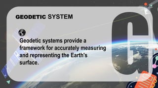
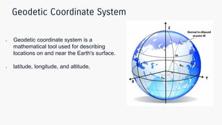
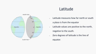
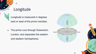
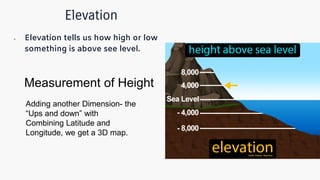
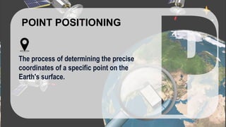
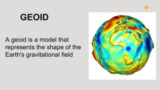
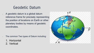
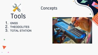
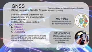
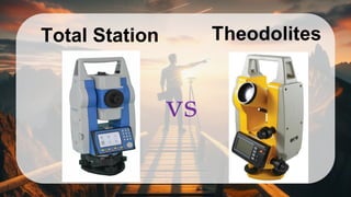
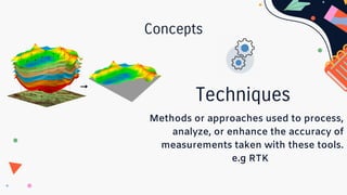
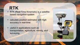
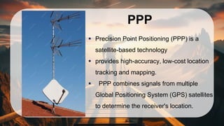
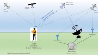
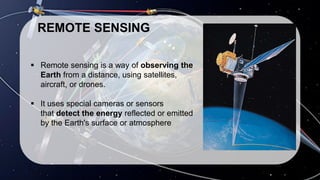
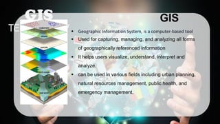
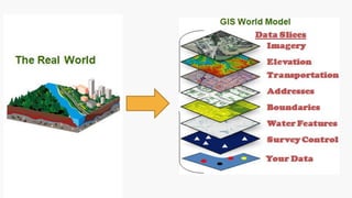
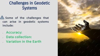
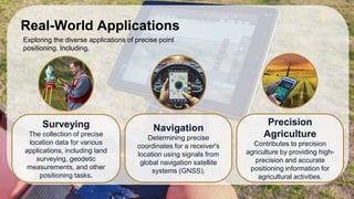
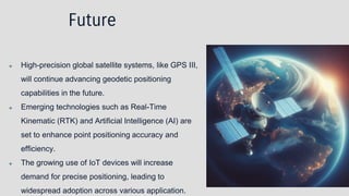
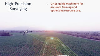
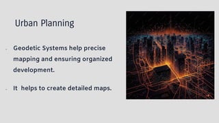
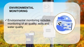
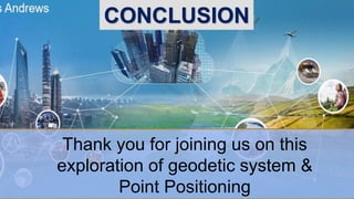
Geodetic System &
Point Positioning
Presented by
Group-4
ROLL: 2131012
2131014
2131029
2131030
2131031
✓ Introduction
✓ Fundamental Concept
✓ Tools and Techniques
✓ Challenges, Application and Future
✓ Case Studies and Conclusion
✓ QNA
Contents
GEODETIC SYSTEM
Geodetic systems provide a
framework for accurately measuring
and representing the Earth's
surface.
Geodetic Coordinate System
● Geodetic coordinate system is a
mathematical tool used for describing
locations on and near the Earth's surface.
● latitude, longitude, and altitude,
Latitude
● Latitude measures how far north or south
a place is from the equator
● Latitude values are positive to the north,
negative to the south.
● Zero degrees of latitude is the line of
equator.
Longitude
● Longitude is measured in degrees
east or west of the prime meridian.
● The prime runs through Greenwich,
London, and separates the eastern
and western hemispheres.
Elevation
● Elevation tells us how high or low
something is above see level.
Measurement of Height
Adding another Dimension- the
“Ups and down” with
Combining Latitude and
Longitude, we get a 3D map.
POINT POSITIONING
The process of determining the precise
coordinates of a specific point on the
Earth's surface.
GEOID
A geoid is a model that
represents the shape of the
Earth's gravitational field
Geodetic Datum
● A geodetic datum is a global datum
reference frame for precisely representing
the position of locations on Earth or other
planetary bodies by means of geodetic
coordinates.
● The common Two types of Datum including:
1. Horizontal
2. Vertical
Concepts
1. GNSS
2. THEODOLITES
3. TOTAL STATION
Tools
GNSS
▪ Global Navigation Satellite System
The capabilities of Global Navigation Satellite
Systems. Including
GNSS is a network of satellites that
provide location and time information
to GPS receivers.
GNSS performs using 4 criteria
1. Accuracy
2. Integrity
3. Continuity
4. Availability
MAPPING
Locate features that can
be incorporated into GIS
NAVIGATION
GNSS enables precise
location and navigation
using signals from
satellites.
Global Navigation Satellite Systems (GNSS)
such as GPS, GLONASS, and Galileo play a
vital role in point positioning.
Total Station
vs
Concepts
Methods or approaches used to process,
analyze, or enhance the accuracy of
measurements taken with these tools.
e.g RTK
Techniques
RTK
▪ RTK (Real-Time Kinematic) is a satellite-
based navigation system
▪ calculate position estimates with high
accuracy in real-time
▪ useful in applications such as
transportation, agriculture, mining, and
surveying.
PPP
▪ Precision Point Positioning (PPP) is a
satellite-based technology
▪ provides high-accuracy, low-cost location
tracking and mapping.
▪ PPP combines signals from multiple
Global Positioning System (GPS) satellites
to determine the receiver's location.
REMOTE SENSING
▪ Remote sensing is a way of observing the
Earth from a distance, using satellites,
aircraft, or drones.
▪ It uses special cameras or sensors
that detect the energy reflected or emitted
by the Earth's surface or atmosphere
GIS
▪ Geographic Information System, is a computer-based tool
▪ Used for capturing, managing, and analyzing all forms
of geographically referenced information
▪ It helps users visualize, understand, interpret and
analyze.
▪ can be used in various fields including urban planning,
natural resources management, public health, and
emergency management.
Challenges in Geodetic
Systems
Some of the challenges that
can arise in geodetic systems
include:
● Accuracy:
● Data collection:
● Variation in the Earth
Real-World Applications
Exploring the diverse applications of precise point
positioning. Including,
Surveying
The collection of precise
location data for various
applications, including land
surveying, geodetic
measurements, and other
positioning tasks.
Navigation
Determining precise
coordinates for a receiver's
location using signals from
global navigation satellite
systems (GNSS).
Precision
Agriculture
Contributes to precision
agriculture by providing high-
precision and accurate
positioning information for
agricultural activities.
Future
❖ High-precision global satellite systems, like GPS III,
will continue advancing geodetic positioning
capabilities in the future.
❖ Emerging technologies such as Real-Time
Kinematic (RTK) and Artificial Intelligence (AI) are
set to enhance point positioning accuracy and
efficiency.
❖ The growing use of IoT devices will increase
demand for precise positioning, leading to
widespread adoption across various application.
High-Precision
Surveying
● GNSS guide machinery for
accurate farming and
optimizing resourse use.
Urban Planning
● Geodetic Systems help precise
mapping and ensuring organized
development.
● It helps to create detailed maps.
c
ENVIRONMENTAL
MONITORING
✓ Environmental monitoring includes
monitoring of air quality, soils and
water quality
Thank you for joining us on this
exploration of geodetic system &
Point Positioning
CONCLUSION
Geodetic System & Point Positioning .pdf

Geodetic System & Point Positioning .pdf

  • 1.
    Geodetic System & PointPositioning Presented by Group-4 ROLL: 2131012 2131014 2131029 2131030 2131031
  • 2.
    ✓ Introduction ✓ FundamentalConcept ✓ Tools and Techniques ✓ Challenges, Application and Future ✓ Case Studies and Conclusion ✓ QNA Contents
  • 3.
    GEODETIC SYSTEM Geodetic systemsprovide a framework for accurately measuring and representing the Earth's surface.
  • 4.
    Geodetic Coordinate System ●Geodetic coordinate system is a mathematical tool used for describing locations on and near the Earth's surface. ● latitude, longitude, and altitude,
  • 5.
    Latitude ● Latitude measureshow far north or south a place is from the equator ● Latitude values are positive to the north, negative to the south. ● Zero degrees of latitude is the line of equator.
  • 6.
    Longitude ● Longitude ismeasured in degrees east or west of the prime meridian. ● The prime runs through Greenwich, London, and separates the eastern and western hemispheres.
  • 7.
    Elevation ● Elevation tellsus how high or low something is above see level. Measurement of Height Adding another Dimension- the “Ups and down” with Combining Latitude and Longitude, we get a 3D map.
  • 8.
    POINT POSITIONING The processof determining the precise coordinates of a specific point on the Earth's surface.
  • 9.
    GEOID A geoid isa model that represents the shape of the Earth's gravitational field
  • 10.
    Geodetic Datum ● Ageodetic datum is a global datum reference frame for precisely representing the position of locations on Earth or other planetary bodies by means of geodetic coordinates. ● The common Two types of Datum including: 1. Horizontal 2. Vertical
  • 12.
  • 13.
    GNSS ▪ Global NavigationSatellite System The capabilities of Global Navigation Satellite Systems. Including GNSS is a network of satellites that provide location and time information to GPS receivers. GNSS performs using 4 criteria 1. Accuracy 2. Integrity 3. Continuity 4. Availability MAPPING Locate features that can be incorporated into GIS NAVIGATION GNSS enables precise location and navigation using signals from satellites. Global Navigation Satellite Systems (GNSS) such as GPS, GLONASS, and Galileo play a vital role in point positioning.
  • 14.
  • 15.
    Concepts Methods or approachesused to process, analyze, or enhance the accuracy of measurements taken with these tools. e.g RTK Techniques
  • 16.
    RTK ▪ RTK (Real-TimeKinematic) is a satellite- based navigation system ▪ calculate position estimates with high accuracy in real-time ▪ useful in applications such as transportation, agriculture, mining, and surveying.
  • 17.
    PPP ▪ Precision PointPositioning (PPP) is a satellite-based technology ▪ provides high-accuracy, low-cost location tracking and mapping. ▪ PPP combines signals from multiple Global Positioning System (GPS) satellites to determine the receiver's location.
  • 19.
    REMOTE SENSING ▪ Remotesensing is a way of observing the Earth from a distance, using satellites, aircraft, or drones. ▪ It uses special cameras or sensors that detect the energy reflected or emitted by the Earth's surface or atmosphere
  • 21.
    GIS ▪ Geographic InformationSystem, is a computer-based tool ▪ Used for capturing, managing, and analyzing all forms of geographically referenced information ▪ It helps users visualize, understand, interpret and analyze. ▪ can be used in various fields including urban planning, natural resources management, public health, and emergency management.
  • 23.
    Challenges in Geodetic Systems Someof the challenges that can arise in geodetic systems include: ● Accuracy: ● Data collection: ● Variation in the Earth
  • 24.
    Real-World Applications Exploring thediverse applications of precise point positioning. Including, Surveying The collection of precise location data for various applications, including land surveying, geodetic measurements, and other positioning tasks. Navigation Determining precise coordinates for a receiver's location using signals from global navigation satellite systems (GNSS). Precision Agriculture Contributes to precision agriculture by providing high- precision and accurate positioning information for agricultural activities.
  • 25.
    Future ❖ High-precision globalsatellite systems, like GPS III, will continue advancing geodetic positioning capabilities in the future. ❖ Emerging technologies such as Real-Time Kinematic (RTK) and Artificial Intelligence (AI) are set to enhance point positioning accuracy and efficiency. ❖ The growing use of IoT devices will increase demand for precise positioning, leading to widespread adoption across various application.
  • 27.
    High-Precision Surveying ● GNSS guidemachinery for accurate farming and optimizing resourse use.
  • 28.
    Urban Planning ● GeodeticSystems help precise mapping and ensuring organized development. ● It helps to create detailed maps.
  • 29.
    c ENVIRONMENTAL MONITORING ✓ Environmental monitoringincludes monitoring of air quality, soils and water quality
  • 30.
    Thank you forjoining us on this exploration of geodetic system & Point Positioning CONCLUSION