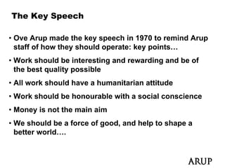
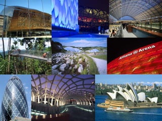
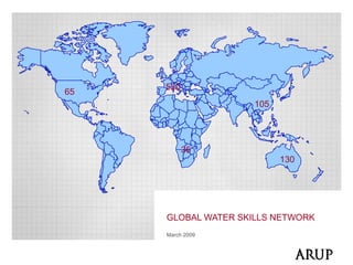
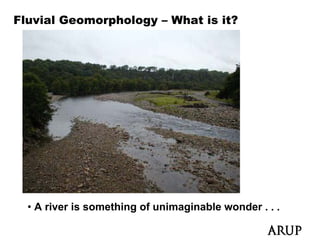
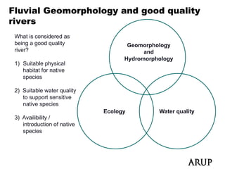
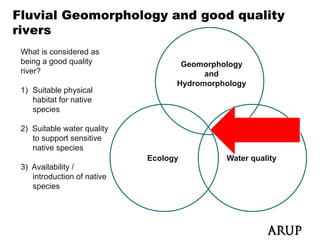
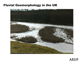
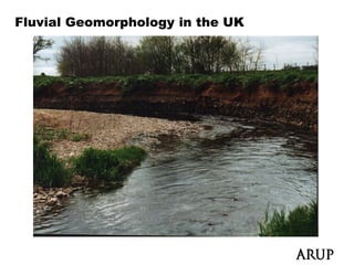
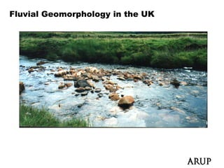
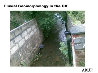
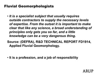
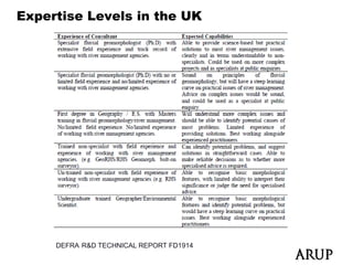
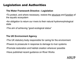
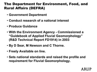
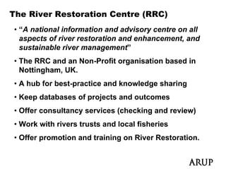
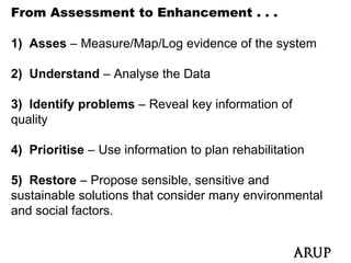
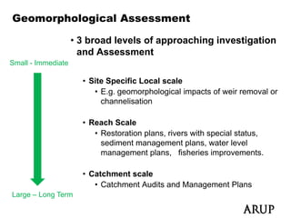
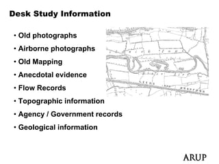
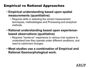
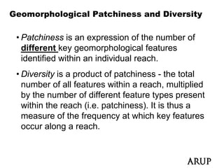
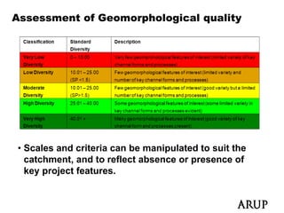
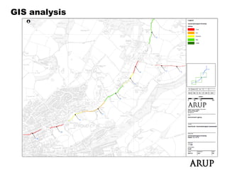
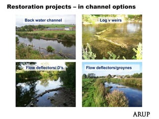
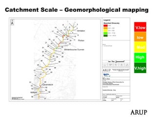
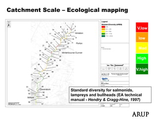
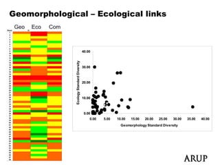
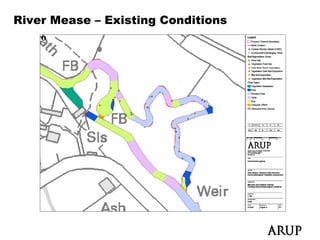
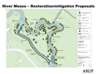
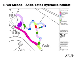
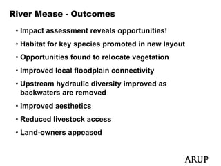
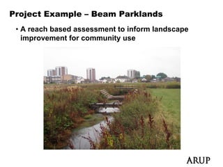
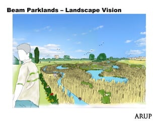
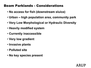
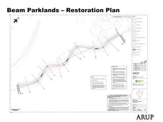
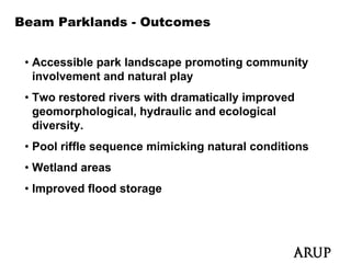
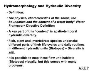
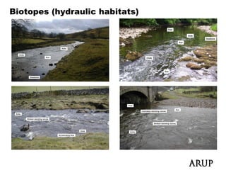
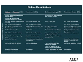
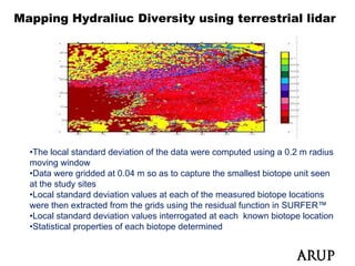
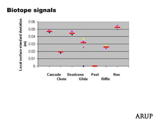
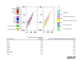
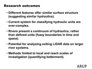
Fluvial Geomorphology –
From Theory to Practice
Dr David Hetherington
Ove Arup and Partners, Newcastle upon Tyne, UK.


Friday 4th June 2010, Sustainable Cities Forum
Universidad Javeriana Bogota Colombia
            Javeriana, Bogota,
Personal Profile – David Hetherington
 • BSc Geography
 • MSc Catchment Dynamics and Management
 • PhD Remote Sensing and Fluvial Geomorphology
 • Have worked in Fluvial Geomorphology for 10 years.
 • Employed for Over Arup and Partners (“ARUP”) for
   5 years.
     y
 • My work relates to River Restoration,
   Geomorphological Assessment, Flood Risk
   Management and Geomatics.
 • I operate the Arup “Geomorphology” and “Remote
   Sensing” Communities (appx 80 staff).
   S    i ”C          iti (       t ff)
Research Profile

 • Geomorphological Evolution
 • U of T
   Use f Terrestrial LiDAR (Li ht Detection and
                ti l       (Light D t ti      d
   Ranging) in Rivers
 • Use of Terrestrial LiDAR in Engineering
 • Fish Habitat
 • Hydromorphology and Hydraulics
 • The use of Urban Models for Flood Risk
   Management
   M           t
 • Fluvial Geomorphology and River Restoration
Ove Arup and Partners (“ARUP”)

• An international multi disciplinary
  consultancy firm of engineers,
  scientists and designers (>10,000 staff)
    i ti t     dd i         ( 10 000 t ff)
• Founded in 1946 by Ove Arup
  Sydney Opera House was an
  early project.
• Ove was an engineer and philosopher (he died in 1988)
• Recent large projects including much of the Beijing
  Olympics.
• Independent and staff owned (trust).
• Please visit www arup com
               www.arup.com
The Key Speech

• Ove Arup made the key speech in 1970 to remind Arup
  staff of how they should operate: key points…
                                        points
• Work should be interesting and rewarding and be of
  the best quality p
           q     y possible
• All work should have a humanitarian attitude
• Work should be honourable with a social conscience
• Money is not the main aim
• We should be a force of good, and help to shape a
  better world….
520
65
                     105


           35
                           130


     GLOBAL WATER SKILLS NETWORK
     March 2009
Fluvial Geomorphology – What is it?


  • A river is something of unimaginable wonder . . .
Fluvial Geomorphology – What is it?


   • An understanding of river behaviour . . . .
Fluvial Geomorphology – What is it?
 • A complex earth science using elements of
   Hydraulics, Geology and Physics.
 • “the study of sediment sources, fluxes and storage
   within the river catchment and channel over short,
   medium and longer timescales and of the resultant
   channel and floodplain morphology” (Newson and
   Sear 1993).
 • The study of river form-process interactions and
   feedbacks over many scales, from the single grain
   up to the entire catchment
                    catchment.
 • In Short: An well-qualified Fluvial Geomorphologist
   understands how rivers behave, and can use this
                                    ,
   knowledge to manage them appropriately . . .
Fluvial Geomorphology – Catchment Processes
Fluvial Geomorphology
– Catchment Controls
• Catchment nature
  ultimately determines
  habitat in natural
  conditions
• Diract (
         (local) and
               )
  Indirect (Catchment)
  Anthropogenic changes
         p g           g
  disrupt natural reactions
  and responses
• Taken from Brierley and
  Fryirs, 2007 – River
  styles
Fluvial Geomorphology – Small Scale
Fluvial Geomorphology – Why do we need it?
(1)


• Rivers are the arteries of the landscape . . .
• Freshwater rivers are valuable and only cover
  around 0.0001% of the Earth’s Surface. (0.0002% of
                                         (
  total volume of water) – NASA estimate
• Natural rivers are physically diverse over short
  distances supporting unique assemblages
• Healthy river systems typically offer better fish
  stocks, and better quality water to local
  communities.
Fluvial Geomorphology – Why do we need it?
(2)


• Healthy meandering systems can help to maintain
        y           g y             p
  aggracultural water table levels.
• Upland meandering systems can provide upstream flood
  storage (reducing flood risk downstream).
• Designing with natural geomorphological processes is
  key
  k if new engineering schemes are to be sustainable
                i    i     h           b       i bl
  and environmentally sensitive.
• Rivers are important community features and
  boundaries
Fluvial Geomorphology – Why do we need it?
(3)


• Rivers are hydraulically and morphologically dynamic in
  time, making then unique spaces.
• Support varied and sometimes rare flora and fauna
    pp
  (which has evolved to natural systems)
  • Damage needs repair

• As with most habitats, the quality of the physical space
  plays a major role in promoting healthy ecology
•N t
 Natural and restored rivers look better and make people
       l d      t   d i      l k b tt      d   k      l
 happy!
Ecology - Fisheries
Fluvial Geomorphology and good quality
rivers
   e s
 What is considered as
 being a good quality               Geomorphology
                                               gy
  i ?
 river?                                  and
                                   Hydromorphology
 1) Suitable physical
    habitat for native
    species

 2) Suitable water quality
    to support sensitive
    native species
                             Ecology         Water quality
 3) Availibility /
    introduction of native
    species
Fluvial Geomorphology and good quality
rivers
   e s
 What is considered as
 being a good quality               Geomorphology
                                               gy
  i ?
 river?                                  and
                                   Hydromorphology
 1) Suitable physical
    habitat for native
    species

 2) Suitable water quality
    to support sensitive
    native species
                             Ecology         Water quality
 3) Availability /
    introduction of native
    species
Fluvial Geomorphology in the UK
Fluvial Geomorphologists

 • It is a specialist subject that usually requires
   outside contractors to supply the necessary levels
   of expertise. From the outset it is important to make
   clear that like any science, a broad understanding of
   principles only gets you so far, and a little
                                  far
   knowledge can be a very dangerous thing.
 Source: (DEFRA) R&D TECHNICAL REPORT FD1914
         (DEFRA),                     FD1914,
  Applied Fluvial Geomorphology.


 • It is a profession, and a job of responsibility
Expertise Levels in the UK


     DEFRA R&D TECHNICAL REPORT FD1914
Legislation and Authorities
 The Water Framework Directive - Legislation
 •To protect, and where necessary, restore the structure and function of
 the aquatic ecosystem
 •An obligation to return our rivers to their natural hydromorphological
 state
 •The aim of achieving “good ecological status”


 The UK Environment Agency
 •The UK statutory body responsible for caring for the environment
 •Powers to prosecute in response to damage to river systems
 •Promote restoration and habitat creation wherever possible
 •Have published recent guidance on Ri
  H      bli h d      t id          River W k
                                          Works
The Department for Environment, Food, and
Rural Affairs (DEFRA)
 • Government Department
 • Conduct research of a national interest
 • Produce Guidance
 • With the Environment Agency - C Commissioned a
   “Guidebook of Applied Fluvial Geomorphology”
   (
   (R&D Technical Report FD1914) in 2003
                    p            )
 • By D Sear, M Newson and C Thorne.
 • Freely Available on line.
                       line
 • Sets national standards and raised the profile and
   requirement for Fluvial Geomorphology.
The River Restoration Centre (RRC)
• “A national information and advisory centre on all
  aspects of river restoration and enhancement, and
  sustainable river management
                    management”
• The RRC and an Non-Profit organisation based in
  Nottingham, UK.
• A hub for best-practice and knowledge sharing
• Keep databases of projects and outcomes
• Offer consultancy services (checking and review)
• Work with rivers trusts and local fisheries
• Offer promotion and training on River Restoration.
Drivers for Geomorphological Studies and
work
 • Ecology
 • Fishing
 • Social (Recreation / Community)
 • Landscape Improvement
 • Stability (Land Erosion)
 • Understanding of impacts of river change
 • Engineering (allowing for natural processes)
 • Flood Risk Management
 • Sediment Management
                g
From Assessment to Enhancement . . .

1) Asses – Measure/Map/Log evidence of the system

2) Understand – Analyse the Data

3) Identify problems – Reveal key information of
quality

4) Prioritise – Use information to plan rehabilitation

5) Restore – Propose sensible, sensitive and
sustainable solutions that consider many environmental
and social factors.
Geomorphological Assessment

                    • 3 broad levels of approaching investigation
                      and Assessment
Small - Immediate

                      • Site Specific Local scale
                         • E g geomorphological impacts of weir removal or
                           E.g.
                           channelisation

                      • Reach Scale
                         • Restoration plans, rivers with special status,
                           sediment management plans, water level
                           management p
                                g        plans, fisheries improvements.
                                              ,              p

                      • Catchment scale
                         • Catchment Audits and Management Plans
Large – Long Term
Desk Study Information

• Old photographs
• Ai b
  Airborne photographs
            h t     h
• Old Mapping
• Anecdotal evidence
• Flow Records
• Topographic information
• Agency / Government records
   g   y
• Geological information
Empirical vs Rational Approaches
 • Empirical understanding based upon spatial
   measurements (quantitative)
   • Requires skills in selecting the correct measurement
     techniques, methodologies and Processing and analytical
     methods.

 • Rational understanding based upon experience-
   based observations (qualitative)
   • Requires “hands-on” experience in various river systems to
        q                   p                         y
     understand how they operate under different conditions, and
     react to catchment changes.

 • Most studies use a combination of Empirical and
   Rational Geomorphological work.
Empirical Tools – Field mapping


• Locating features onto maps or direct into GIS
• Handheld GIS has built in GPS technology (How
  long until we can install GIS on our I-phones?)
Empirical Tools – Surveying and Terrestrial LiDAR
Rational Tools - Experience

 • Field proforma allowing descriptions and mapping
   of:
   • Types of erosion and deposition
   • Types of sediment Bar Features
   • Severity of Erosion
   • Severity of Deposition
   • Evidence of active and dormant processes
   • Evidence of Morphological features (Riffles, pools etc)
   • Hydromorphological units (runs, cascades, riffles, ponded
     flow etc)
             )
   • Anthropogenic influences (farming, dumping, livestock
     etc)
Rational Tools - Proforma
Geomorphological Patchiness and Diversity

 • Patchiness is an expression of the number of
   different key geomorphological features
   identified within an individual reach.
 • Di
   Diversity i a product of patchiness - th t t l
          it is     d t f t hi              the total
   number of all features within a reach, multiplied
   by the number of different feature types present
   within the reach (i.e. patchiness). It is thus a
   measure of the frequency at which key features
                       q     y               y
   occur along a reach.
Assessment of Geomorphological quality


• Scales and criteria can be manipulated to suit the
                                 p
  catchment, and to reflect absence or presence of
  key project features.
GIS analysis
Restoration options
Restoration projects – in channel options

     Back water channel            Log v weirs


      Flow deflectors/ D’s
                       Ds    Flow deflectors/groynes
Catchment Scale – Geomorphological mapping

   Geomorphological Standard
   Diversity                          V.low

                                      low

                                      Mod

                                      High

                                     V.high
                                     V hi h
Catchment Scale – Ecological mapping


                                                   V.low

                                                    low

                                                    Mod

                                                   High

                                                   V.high
                                                   V hi h


                  Standard diversity for salmonids,
                  lampreys and bullheads (EA technical
                  manual - Hendry & Cragg-Hine, 1997)
Geomorphological – Ecological links
 Geo   Eco   Com


                                               40.00                             R-Sq = 7.8%; P = 0.037


                                     versity
                                               30.00


                   Ecolog Standard Div
                                               20.00
                        gy


                                               10.00


                                                0.00
                                                   0.00
                                                   0 00   5.00
                                                          5 00   10.00
                                                                 10 00   15.00
                                                                         15 00   20.00
                                                                                 20 00   25.00
                                                                                         25 00   30.00
                                                                                                 30 00   35.00
                                                                                                         35 00   40.00
                                                                                                                 40 00
                                                                   Geomorphology Standard Diversity
Geomorphological – Ecological links
 Geo   Eco   Com


                               R-Sq = 7.8%; P = 0.037


                   Target for restoration
                   Good Quality y


                   Judgement required
Project Example – River Mease
 • A Site Specific – Geomorphological Impact
   assessment of removing a weir
Project Example – River Mease
River Mease - Considerations
 • Important habitat for Bullhead
 • Important habitat for Spined Loach
 • Local regime will change
 • Local sediment transport potential will change
 • Local hydraulic diversity will change
 • Upstream impacts?
 • Downstream Impacts?
 • Flood Risk?
 • Stability
River Mease – Existing Conditions
River Mease – Restoration/mitigation Proposals
River Mease – Anticipated hydraulic habitat
River Mease - Outcomes

 • Impact assessment reveals opportunities!
 • Habitat for key species promoted in new layout
                 y p       p                 y
 • Opportunities found to relocate vegetation
 • Improved local floodplain connectivity
 • Upstream hydraulic diversity improved as
   backwaters are removed
 • Improved aesthetics
 • Reduced livestock access
 • Land-owners appeased
Project Example – Beam Parklands
 • A reach based assessment to inform landscape
   improvement for community use
Beam Parklands – Landscape Vision
Beam Parklands - Considerations
 • No access for fish (downstream sluice)
 • Urban – high population area, community park
 • Very Low Morphological or Hydraulic Diversity
 • Heavily modified system
 • Currently inaccessible
 • Very low gradient
 • Invasive plants
 • Polluted site
 • No key species present
Beam Parklands – Restoration Plan
Beam Parklands - Outcomes


 • Accessible park landscape promoting community
   involvement and natural play
 • Two restored rivers with dramatically improved
   geomorphological,
   geomorphological hydraulic and ecological
   diversity.
 • Pool riffle sequence mimicking natural conditions
 • Wetland areas
 • Improved flood storage
Hydromorphology and Hydraulic Diversity
 • Definition:
 “The physical characteristics of the shape, the
  boundaries and the content of a water body” Water
  Framework Directive Definition
 • A key part of this “content” is spatio-temporal
     k      t f thi “     t t” i      ti t       l
   hydraulic diversity.
 • Fish plant and invertebrate species undertake
   Fish,
   different parts of their life cycles and daily routines
   in different hydraulic units (Biotopes) – Diversity is
   key.
 • It is possible to map these flow unit habitats
   (Biotopes) visually, b t this comes with many
   (Bi t      ) i    ll but thi           ith
   problems.
Biotopes (hydraulic habitats)
                  Biotope Types
Mapping Hydraliuc Diversity using terrestrial lidar


  •The local standard deviation of the data were computed using a 0 2 m radius
                                                                     0.2
  moving window
  •Data were gridded at 0.04 m so as to capture the smallest biotope unit seen
  at the study sites
  •Local standard deviation values at each of the measured biotope locations
  were then extracted from the grids using the residual function in SURFER™
  •Local standard deviation values interrogated at each known biotope location
  •Statistical properties of each biotope determined
   Statistical
Biotope signals
Results: Typology validation


                  frequency biotope successfully
Unit descriptor                       classified   frequency amalgamated biotope successfully classified

Run                                        0.00                                                    0.90
Glide
Glid                                       0.14
                                           0 14                                                    0.75
                                                                                                   0 75
Chute                                      0.20                                                    0.59
Rapid                                      0.38                                                    1.00
Riffle                                     0.25                                                    0.55
Deadwater
D d t                                      0.71
                                           0 71                                                    0.71
                                                                                                   0 71
Pool                                       1.00                                                    1.00
Research outcomes

 • Different features offer similar surface structure
   (suggesting similar hydraulics).
 • Current system for classifying hydraulic units are
   over-complex.
 • Rivers present a continuum of hydraulics, rather
   than defined units (fuzzy boundaries in time and
   space).
 • Potential for analysing exiting LiDAR data on larger
   river systems.
          y
 • Methods limited to local and reach scales of
   investigation (quantifying betterment).
Terrestrial lidar and design
Conclusions – Fluvial Geomorphology
• Diagnosing the problems and causes is key to
  management.
• The scale that processes are operating at should
  determine the scale of the study, and the response.
• S ll scale processes/problems = Local studies
  Small   l           /   bl      L   l t di
• Catchment scale processes/problems = Large
  studies
• Consideration of this early on makes schemes
  sustainable,
  sustainable and adds value (in many ways)
                                       ways).
• It is a serious and complex subject and expertise is
  required.
     q
Conclusions – River Restoration
 • We need to learn from, and correct historical
   mistakes.
 • M h existing guidance and project experience.
   Much i ti      id       d    j t       i
 • Should be based on a sound understanding of the
   River System
         System.
 • Needs to be focused on the drivers.
 • What conditions to key species require?
 • Provides multiple direct benefits (and residual
   benefits e.g. water quality).
   b   fit         t      lit )
 • Often a far more cost effective solution than hard
   engineering.
   engineering
River Restoration: Costs
 • Hard to generalise in terms of economics (projects
   so diverse!)
 • S ft V H d (S ft approximately 25-50% cheaper at
   Soft Vs Hard (Soft     i t l 25 50% h          t
   initial outlay)
 • Cost per m <50% for soft
 • Engineers vs Bio-engineers (bioengineering groups
   small with low overheads - 50% in some cases)
 • Soft then requires monitoring, and maintenance
   • But has a longer design life because of this
                  g       g

 • Restoration should be part of other schemes.
   • Additional cost – but great additional benefit

 • Cost does not reflect “value”
River Restoration: Limitations


 • A river can never be fully “restored” back to its
   original state.
     i i l t t
 • Sometimes difficult to design for extreme flood
   events.
   events
 • Sometimes restoration has to be done within
   constraints
 • Huge potential benefits make the limitations worth
   working with
Acknowledgements

 • The project organisers in Bogota!
 • Arup for supporting my involvement
 • The below Arup people for contributing and/ helping
   in various ways towards my attendance and
                y              y
   presentation at this forum:
 Patrick Kuhn, Amit Dutta, Dr Sally German, David Wilkes, Prof
  Mark Fletcher Daniel Newton Daniel House Jane Saul
        Fletcher,       Newton,         House,     Saul.

 • Dr David Bradley – APEM aquatic scientists
 • Research Colleagues
    • Dr George Heritage – Salford University, UK
    • Dr David Milan – University of Gloucestershire, UK
Questions?

                 david.hetherington@arup.com
                     (Please stay in touch!)


Useful Additional Background Information . .

 • DEFRA: www.defra.gov.uk (search for “fluvial g
                    g      (                    geomorphology”)
                                                      p    gy )
 • EA fluvial design guide: http://evidence.environment-
   agency.gov.uk/FCERM/en/FluvialDesignGuide.aspx
 • River Restoration Centre: www.therrc.co.uk

Forum david hetherington

  • 1.
    Fluvial Geomorphology – FromTheory to Practice Dr David Hetherington Ove Arup and Partners, Newcastle upon Tyne, UK. Friday 4th June 2010, Sustainable Cities Forum Universidad Javeriana Bogota Colombia Javeriana, Bogota,
  • 2.
    Personal Profile –David Hetherington • BSc Geography • MSc Catchment Dynamics and Management • PhD Remote Sensing and Fluvial Geomorphology • Have worked in Fluvial Geomorphology for 10 years. • Employed for Over Arup and Partners (“ARUP”) for 5 years. y • My work relates to River Restoration, Geomorphological Assessment, Flood Risk Management and Geomatics. • I operate the Arup “Geomorphology” and “Remote Sensing” Communities (appx 80 staff). S i ”C iti ( t ff)
  • 3.
    Research Profile •Geomorphological Evolution • U of T Use f Terrestrial LiDAR (Li ht Detection and ti l (Light D t ti d Ranging) in Rivers • Use of Terrestrial LiDAR in Engineering • Fish Habitat • Hydromorphology and Hydraulics • The use of Urban Models for Flood Risk Management M t • Fluvial Geomorphology and River Restoration
  • 4.
    Ove Arup andPartners (“ARUP”) • An international multi disciplinary consultancy firm of engineers, scientists and designers (>10,000 staff) i ti t dd i ( 10 000 t ff) • Founded in 1946 by Ove Arup Sydney Opera House was an early project. • Ove was an engineer and philosopher (he died in 1988) • Recent large projects including much of the Beijing Olympics. • Independent and staff owned (trust). • Please visit www arup com www.arup.com
  • 5.
    The Key Speech •Ove Arup made the key speech in 1970 to remind Arup staff of how they should operate: key points… points • Work should be interesting and rewarding and be of the best quality p q y possible • All work should have a humanitarian attitude • Work should be honourable with a social conscience • Money is not the main aim • We should be a force of good, and help to shape a better world….
  • 7.
    520 65 105 35 130 GLOBAL WATER SKILLS NETWORK March 2009
  • 8.
    Fluvial Geomorphology –What is it? • A river is something of unimaginable wonder . . .
  • 9.
    Fluvial Geomorphology –What is it? • An understanding of river behaviour . . . .
  • 10.
    Fluvial Geomorphology –What is it? • A complex earth science using elements of Hydraulics, Geology and Physics. • “the study of sediment sources, fluxes and storage within the river catchment and channel over short, medium and longer timescales and of the resultant channel and floodplain morphology” (Newson and Sear 1993). • The study of river form-process interactions and feedbacks over many scales, from the single grain up to the entire catchment catchment. • In Short: An well-qualified Fluvial Geomorphologist understands how rivers behave, and can use this , knowledge to manage them appropriately . . .
  • 11.
    Fluvial Geomorphology –Catchment Processes
  • 12.
    Fluvial Geomorphology – CatchmentControls • Catchment nature ultimately determines habitat in natural conditions • Diract ( (local) and ) Indirect (Catchment) Anthropogenic changes p g g disrupt natural reactions and responses • Taken from Brierley and Fryirs, 2007 – River styles
  • 13.
  • 14.
    Fluvial Geomorphology –Why do we need it? (1) • Rivers are the arteries of the landscape . . . • Freshwater rivers are valuable and only cover around 0.0001% of the Earth’s Surface. (0.0002% of ( total volume of water) – NASA estimate • Natural rivers are physically diverse over short distances supporting unique assemblages • Healthy river systems typically offer better fish stocks, and better quality water to local communities.
  • 15.
    Fluvial Geomorphology –Why do we need it? (2) • Healthy meandering systems can help to maintain y g y p aggracultural water table levels. • Upland meandering systems can provide upstream flood storage (reducing flood risk downstream). • Designing with natural geomorphological processes is key k if new engineering schemes are to be sustainable i i h b i bl and environmentally sensitive. • Rivers are important community features and boundaries
  • 16.
    Fluvial Geomorphology –Why do we need it? (3) • Rivers are hydraulically and morphologically dynamic in time, making then unique spaces. • Support varied and sometimes rare flora and fauna pp (which has evolved to natural systems) • Damage needs repair • As with most habitats, the quality of the physical space plays a major role in promoting healthy ecology •N t Natural and restored rivers look better and make people l d t d i l k b tt d k l happy!
  • 17.
  • 18.
    Fluvial Geomorphology andgood quality rivers e s What is considered as being a good quality Geomorphology gy i ? river? and Hydromorphology 1) Suitable physical habitat for native species 2) Suitable water quality to support sensitive native species Ecology Water quality 3) Availibility / introduction of native species
  • 19.
    Fluvial Geomorphology andgood quality rivers e s What is considered as being a good quality Geomorphology gy i ? river? and Hydromorphology 1) Suitable physical habitat for native species 2) Suitable water quality to support sensitive native species Ecology Water quality 3) Availability / introduction of native species
  • 20.
  • 21.
  • 22.
  • 23.
  • 24.
    Fluvial Geomorphologists •It is a specialist subject that usually requires outside contractors to supply the necessary levels of expertise. From the outset it is important to make clear that like any science, a broad understanding of principles only gets you so far, and a little far knowledge can be a very dangerous thing. Source: (DEFRA) R&D TECHNICAL REPORT FD1914 (DEFRA), FD1914, Applied Fluvial Geomorphology. • It is a profession, and a job of responsibility
  • 25.
    Expertise Levels inthe UK DEFRA R&D TECHNICAL REPORT FD1914
  • 26.
    Legislation and Authorities The Water Framework Directive - Legislation •To protect, and where necessary, restore the structure and function of the aquatic ecosystem •An obligation to return our rivers to their natural hydromorphological state •The aim of achieving “good ecological status” The UK Environment Agency •The UK statutory body responsible for caring for the environment •Powers to prosecute in response to damage to river systems •Promote restoration and habitat creation wherever possible •Have published recent guidance on Ri H bli h d t id River W k Works
  • 27.
    The Department forEnvironment, Food, and Rural Affairs (DEFRA) • Government Department • Conduct research of a national interest • Produce Guidance • With the Environment Agency - C Commissioned a “Guidebook of Applied Fluvial Geomorphology” ( (R&D Technical Report FD1914) in 2003 p ) • By D Sear, M Newson and C Thorne. • Freely Available on line. line • Sets national standards and raised the profile and requirement for Fluvial Geomorphology.
  • 28.
    The River RestorationCentre (RRC) • “A national information and advisory centre on all aspects of river restoration and enhancement, and sustainable river management management” • The RRC and an Non-Profit organisation based in Nottingham, UK. • A hub for best-practice and knowledge sharing • Keep databases of projects and outcomes • Offer consultancy services (checking and review) • Work with rivers trusts and local fisheries • Offer promotion and training on River Restoration.
  • 29.
    Drivers for GeomorphologicalStudies and work • Ecology • Fishing • Social (Recreation / Community) • Landscape Improvement • Stability (Land Erosion) • Understanding of impacts of river change • Engineering (allowing for natural processes) • Flood Risk Management • Sediment Management g
  • 30.
    From Assessment toEnhancement . . . 1) Asses – Measure/Map/Log evidence of the system 2) Understand – Analyse the Data 3) Identify problems – Reveal key information of quality 4) Prioritise – Use information to plan rehabilitation 5) Restore – Propose sensible, sensitive and sustainable solutions that consider many environmental and social factors.
  • 31.
    Geomorphological Assessment • 3 broad levels of approaching investigation and Assessment Small - Immediate • Site Specific Local scale • E g geomorphological impacts of weir removal or E.g. channelisation • Reach Scale • Restoration plans, rivers with special status, sediment management plans, water level management p g plans, fisheries improvements. , p • Catchment scale • Catchment Audits and Management Plans Large – Long Term
  • 32.
    Desk Study Information •Old photographs • Ai b Airborne photographs h t h • Old Mapping • Anecdotal evidence • Flow Records • Topographic information • Agency / Government records g y • Geological information
  • 33.
    Empirical vs RationalApproaches • Empirical understanding based upon spatial measurements (quantitative) • Requires skills in selecting the correct measurement techniques, methodologies and Processing and analytical methods. • Rational understanding based upon experience- based observations (qualitative) • Requires “hands-on” experience in various river systems to q p y understand how they operate under different conditions, and react to catchment changes. • Most studies use a combination of Empirical and Rational Geomorphological work.
  • 34.
    Empirical Tools –Field mapping • Locating features onto maps or direct into GIS • Handheld GIS has built in GPS technology (How long until we can install GIS on our I-phones?)
  • 35.
    Empirical Tools –Surveying and Terrestrial LiDAR
  • 36.
    Rational Tools -Experience • Field proforma allowing descriptions and mapping of: • Types of erosion and deposition • Types of sediment Bar Features • Severity of Erosion • Severity of Deposition • Evidence of active and dormant processes • Evidence of Morphological features (Riffles, pools etc) • Hydromorphological units (runs, cascades, riffles, ponded flow etc) ) • Anthropogenic influences (farming, dumping, livestock etc)
  • 37.
  • 38.
    Geomorphological Patchiness andDiversity • Patchiness is an expression of the number of different key geomorphological features identified within an individual reach. • Di Diversity i a product of patchiness - th t t l it is d t f t hi the total number of all features within a reach, multiplied by the number of different feature types present within the reach (i.e. patchiness). It is thus a measure of the frequency at which key features q y y occur along a reach.
  • 39.
    Assessment of Geomorphologicalquality • Scales and criteria can be manipulated to suit the p catchment, and to reflect absence or presence of key project features.
  • 40.
  • 41.
  • 42.
    Restoration projects –in channel options Back water channel Log v weirs Flow deflectors/ D’s Ds Flow deflectors/groynes
  • 43.
    Catchment Scale –Geomorphological mapping Geomorphological Standard Diversity V.low low Mod High V.high V hi h
  • 44.
    Catchment Scale –Ecological mapping V.low low Mod High V.high V hi h Standard diversity for salmonids, lampreys and bullheads (EA technical manual - Hendry & Cragg-Hine, 1997)
  • 45.
    Geomorphological – Ecologicallinks Geo Eco Com 40.00 R-Sq = 7.8%; P = 0.037 versity 30.00 Ecolog Standard Div 20.00 gy 10.00 0.00 0.00 0 00 5.00 5 00 10.00 10 00 15.00 15 00 20.00 20 00 25.00 25 00 30.00 30 00 35.00 35 00 40.00 40 00 Geomorphology Standard Diversity
  • 46.
    Geomorphological – Ecologicallinks Geo Eco Com R-Sq = 7.8%; P = 0.037 Target for restoration Good Quality y Judgement required
  • 47.
    Project Example –River Mease • A Site Specific – Geomorphological Impact assessment of removing a weir
  • 48.
  • 49.
    River Mease -Considerations • Important habitat for Bullhead • Important habitat for Spined Loach • Local regime will change • Local sediment transport potential will change • Local hydraulic diversity will change • Upstream impacts? • Downstream Impacts? • Flood Risk? • Stability
  • 50.
    River Mease –Existing Conditions
  • 51.
    River Mease –Restoration/mitigation Proposals
  • 52.
    River Mease –Anticipated hydraulic habitat
  • 53.
    River Mease -Outcomes • Impact assessment reveals opportunities! • Habitat for key species promoted in new layout y p p y • Opportunities found to relocate vegetation • Improved local floodplain connectivity • Upstream hydraulic diversity improved as backwaters are removed • Improved aesthetics • Reduced livestock access • Land-owners appeased
  • 54.
    Project Example –Beam Parklands • A reach based assessment to inform landscape improvement for community use
  • 55.
    Beam Parklands –Landscape Vision
  • 56.
    Beam Parklands -Considerations • No access for fish (downstream sluice) • Urban – high population area, community park • Very Low Morphological or Hydraulic Diversity • Heavily modified system • Currently inaccessible • Very low gradient • Invasive plants • Polluted site • No key species present
  • 57.
    Beam Parklands –Restoration Plan
  • 58.
    Beam Parklands -Outcomes • Accessible park landscape promoting community involvement and natural play • Two restored rivers with dramatically improved geomorphological, geomorphological hydraulic and ecological diversity. • Pool riffle sequence mimicking natural conditions • Wetland areas • Improved flood storage
  • 59.
    Hydromorphology and HydraulicDiversity • Definition: “The physical characteristics of the shape, the boundaries and the content of a water body” Water Framework Directive Definition • A key part of this “content” is spatio-temporal k t f thi “ t t” i ti t l hydraulic diversity. • Fish plant and invertebrate species undertake Fish, different parts of their life cycles and daily routines in different hydraulic units (Biotopes) – Diversity is key. • It is possible to map these flow unit habitats (Biotopes) visually, b t this comes with many (Bi t ) i ll but thi ith problems.
  • 60.
  • 62.
    Mapping Hydraliuc Diversityusing terrestrial lidar •The local standard deviation of the data were computed using a 0 2 m radius 0.2 moving window •Data were gridded at 0.04 m so as to capture the smallest biotope unit seen at the study sites •Local standard deviation values at each of the measured biotope locations were then extracted from the grids using the residual function in SURFER™ •Local standard deviation values interrogated at each known biotope location •Statistical properties of each biotope determined Statistical
  • 63.
  • 64.
    Results: Typology validation frequency biotope successfully Unit descriptor classified frequency amalgamated biotope successfully classified Run 0.00 0.90 Glide Glid 0.14 0 14 0.75 0 75 Chute 0.20 0.59 Rapid 0.38 1.00 Riffle 0.25 0.55 Deadwater D d t 0.71 0 71 0.71 0 71 Pool 1.00 1.00
  • 65.
    Research outcomes •Different features offer similar surface structure (suggesting similar hydraulics). • Current system for classifying hydraulic units are over-complex. • Rivers present a continuum of hydraulics, rather than defined units (fuzzy boundaries in time and space). • Potential for analysing exiting LiDAR data on larger river systems. y • Methods limited to local and reach scales of investigation (quantifying betterment).
  • 66.
  • 67.
    Conclusions – FluvialGeomorphology • Diagnosing the problems and causes is key to management. • The scale that processes are operating at should determine the scale of the study, and the response. • S ll scale processes/problems = Local studies Small l / bl L l t di • Catchment scale processes/problems = Large studies • Consideration of this early on makes schemes sustainable, sustainable and adds value (in many ways) ways). • It is a serious and complex subject and expertise is required. q
  • 68.
    Conclusions – RiverRestoration • We need to learn from, and correct historical mistakes. • M h existing guidance and project experience. Much i ti id d j t i • Should be based on a sound understanding of the River System System. • Needs to be focused on the drivers. • What conditions to key species require? • Provides multiple direct benefits (and residual benefits e.g. water quality). b fit t lit ) • Often a far more cost effective solution than hard engineering. engineering
  • 69.
    River Restoration: Costs • Hard to generalise in terms of economics (projects so diverse!) • S ft V H d (S ft approximately 25-50% cheaper at Soft Vs Hard (Soft i t l 25 50% h t initial outlay) • Cost per m <50% for soft • Engineers vs Bio-engineers (bioengineering groups small with low overheads - 50% in some cases) • Soft then requires monitoring, and maintenance • But has a longer design life because of this g g • Restoration should be part of other schemes. • Additional cost – but great additional benefit • Cost does not reflect “value”
  • 70.
    River Restoration: Limitations • A river can never be fully “restored” back to its original state. i i l t t • Sometimes difficult to design for extreme flood events. events • Sometimes restoration has to be done within constraints • Huge potential benefits make the limitations worth working with
  • 71.
    Acknowledgements • Theproject organisers in Bogota! • Arup for supporting my involvement • The below Arup people for contributing and/ helping in various ways towards my attendance and y y presentation at this forum: Patrick Kuhn, Amit Dutta, Dr Sally German, David Wilkes, Prof Mark Fletcher Daniel Newton Daniel House Jane Saul Fletcher, Newton, House, Saul. • Dr David Bradley – APEM aquatic scientists • Research Colleagues • Dr George Heritage – Salford University, UK • Dr David Milan – University of Gloucestershire, UK
  • 72.
    Questions? david.hetherington@arup.com (Please stay in touch!) Useful Additional Background Information . . • DEFRA: www.defra.gov.uk (search for “fluvial g g ( geomorphology”) p gy ) • EA fluvial design guide: http://evidence.environment- agency.gov.uk/FCERM/en/FluvialDesignGuide.aspx • River Restoration Centre: www.therrc.co.uk