
Recommended
More Related Content
What's hot
What's hot (20)
Similar to Flightline Geo Imagery Info Sheet
Similar to Flightline Geo Imagery Info Sheet (20)
Flightline Geo Imagery Info Sheet
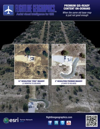
- 1. PREMIUM GIS-READY CONTENT ON-DEMAND When the same old base map is just not good enough 12” RESOLUTION “FREE” IMAGERY (12 MONTHS TO DELIVER) 2” RESOLUTION PREMIUM IMAGERY (2 DAYS TO DELIVER) flightlinegeographics.com
- 2. Flightline Geographics captures premium GIS-ready content from both manned and unmanned platforms. Never before has such high definition survey-grade imagery been available with such short turn-around times. Projects can be planned, captured and delivered within days, instead of weeks or months, making near- realtime monitoring of projects possible. flightlinegeographics.com Connect with us on social media for the latest news and information on UAS for GIS! “GIS relies upon access to content. Flightline Geographics’ use of UAS to capture, process and deliver GIS content in near real time is a real game-changer.” Esri President Jack Dangermond Services are available world-wide and data can be delivered through ArcGIS Online or traditional media. Our online image content can be viewed along with your other GIS map layers and users can navigate around on the map using smartphones and tablets in the field! Key Information: • 1-2” resolutions are easily achievable • 3D point cloud data produced from imagery (.las format) • Content is processed and delivered in days, not weeks or months • Affordable & repeatable throughout project life cycle • GIS-ready delivery via ArcGIS Online! Trademarks provided under license from Esri. Copyright 2015 Flightline Geographics LLC