SlideShare a Scribd company logo
https://registry.opendata.aws/usgs-lidar/ Funding for this ongoiing work was provided by the Community for Data Integration (CDI) from the
project grant:“Enhancing usability of 3DEP data and web services with Jupyter notebooks
• User installs Python modules and runs Jupyter Notebook(s) on personal workstation.
• Performance and job size capabilities depend on local hardware.
• User runs Jupyter Notebook in Google Colaboratory environment on Google’s Cloud Platform.
• No local Python installs or processing required.
• Allocations of 12GB RAM and Google’s high performance CPU/GPUs
• Products directly downloaded to and accessed from the user’s Google Drive
Enhancing usability and utility of USGS 3D Elevation Program
(3DEP) lidar data and web services with Jupyter Notebooks
Cole Speed1,3
, Matthew Beckley1
, Christopher Crosby1
, Viswanath Nandigam2
!"#$%&"&'()"*+
Contact: cole.speed@beg.utexas.edu
1
UNAVCO Inc.; San Diego Supercomputer Center, UC San Diego; 3
Department of Geological Sciences
Jackson School of Geosciences, University of Texas at Austin
600 km
• 3DEP data are available as an Amazon Web Services Public Dataset in Entwine Point Tile (EPT) format for public use.
• Currently, >1800 datasets, >43 trillion lidar points, > 6 million km2
coverage with data acquistion ongoing.
• Project Goal: Develop accessible and usable workflows for accessing, processing, and visualizing 3DEP data
via customizable Python-based Jupyter Notebooks and cloud resources.
The 3D Elevation Program (3DEP)
ipyleaflet
Project Overview
• The 3D Elevation Program, managed by the US Geological Survey, is acquiring quality level 2 or better light
detecting and ranging (lidar) data over the conterminous United States, Hawaii, and US Territories to meet the
growing need for high-resolution 3-D representations of Earth's surface, vegetation, and constructed features.
• OpenTopography, supported by the USGS Community for Data Integration (CDI) program, is developing
well-documented and customizable Jupyter Notebook-based Python workflows for programmatically accessing,
processing, and visualizing 3DEP data products for a variety of use-cases geared toward USGS applications and
for users of point cloud data across the geospatial community.
Example Use-Cases of Jupyter Notebook 3DEP Workflows
z
Distribution, Installation, and Execution
Python Workflows for Accessing, Processing, and Visualizing 3DEP Data
Lidar Point Cloud
CHM
DTM
by
USGS
Watershed
(12
Digit
HUC
Service)
Cutsom
DTM/DSMs
for
USGS
7.5
x
7.5’
Quadragles
Canopy
Height
Model
for
User-defined
AOI
https://github.com/cmspeed/OT_3DEP_Workflows
Topographic
Differencing
of
3DEP
Datasets
We are seeking suggestions for specific use-cases!
USGS 3DEP
7.5 x 7.5’ Quadrangle
DTM
DTM
Differenced DSM
USGS 3DEP
12-Digit USGS WBD
USGS 3DEP
User-defined AOI
USGS 3DEP (2013)
USGS 3DEP (2011)
User-defined AOI
Lidar Point Cloud
5 km
5 km
5 km
Colorize Point Clouds by
Corresponding NAIP Imagery
NAIP Image Service
Correspoinding 3DEP Datset
Colorized point clouds
Text about querying 3DEP
Colorized point clouds
1 km USGS 3DEP
User-defined AOI
1 km
1 km
1 km
5 km
3 km
DSM
DTM
Canopy Height (m)
0 5
2 km
USGS Ground Class - Lidar Points
5 km
USGS Ground Class - Lidar Points
DTM
5 km
Get 3DEP Polygons via API
Construct PDAL Pipelines Execute the PDAL Pipelines
Define AOI on Interactive Map
API request to get up-to-date 3DEP
polygons from USGS lidar repository
(https://github.com/hobu/usgs-lidar)
Extract names, geometries, and
point counts for each dataset
AOI subset of 3DEP data is
downloaded from aws usgs-lidar
Entwine Point Tile (EPT) bucket
Processing stages are applied
Products saved locally
or to Google Drive
Workflow leverages PDAL
(Point Data Abstraction Library)
Customizable PDAL pipelines:
specify resolution and processing
steps (e.g., filtering, reclassifying,
colorizing, gridding)
iPyLeaflet interactive maps / draw
methods / shapefiles for user AOI
Estimate point density for AOI
iPywidgets promote customization
and ease-of-use
Option 2: Install and Execute on Google Colaboratory
Option 1: Local Installation and Execution
QR Code to
Github Repository
2013 - DTM
2011 - DTM Topographic Difference (2013-2011) (m)
-0.5 0.5 (m)
2 km
1 km
3DEP Point Cloud and Digital
Terrain Model (DTM)
Diamond Head Volcano, HI
Colorized 3DEP
Point cloud

More Related Content

Similar to Enhancing usability and utility of USGS 3D Elevation Program (3DEP) lidar data and web services with Jupyter Notebooks

Extending Twitter's Data Platform to Google Cloud
Extending Twitter's Data Platform to Google Cloud Extending Twitter's Data Platform to Google Cloud
Extending Twitter's Data Platform to Google Cloud
lohitvijayarenu
 
Geospatial Data Abstraction Library (GDAL) Enhancement for ESDIS (GEE)
Geospatial Data Abstraction Library (GDAL) Enhancement for ESDIS (GEE)Geospatial Data Abstraction Library (GDAL) Enhancement for ESDIS (GEE)
Geospatial Data Abstraction Library (GDAL) Enhancement for ESDIS (GEE)
The HDF-EOS Tools and Information Center
 
OpenStreetMap in 3D - current developments
OpenStreetMap in 3D - current developmentsOpenStreetMap in 3D - current developments
OpenStreetMap in 3D - current developments
virtualcitySYSTEMS GmbH
 
Hardware and software requirements for gis
Hardware and software requirements for gisHardware and software requirements for gis
Hardware and software requirements for gisSumant Diwakar
 
Amsterdam - The Neo4j Graph Data Platform Today & Tomorrow
Amsterdam - The Neo4j Graph Data Platform Today & TomorrowAmsterdam - The Neo4j Graph Data Platform Today & Tomorrow
Amsterdam - The Neo4j Graph Data Platform Today & Tomorrow
Neo4j
 
Introduction to mago3D, an Open Source Based Digital Twin Platform
Introduction to mago3D, an Open Source Based Digital Twin PlatformIntroduction to mago3D, an Open Source Based Digital Twin Platform
Introduction to mago3D, an Open Source Based Digital Twin Platform
SANGHEE SHIN
 
State of GeoServer
State of GeoServerState of GeoServer
State of GeoServer
Jody Garnett
 
Understanding Hadoop
Understanding HadoopUnderstanding Hadoop
Understanding Hadoop
Ahmed Ossama
 
Tackling "BIG Data": Mobile LiDAR Transportation Project Use Case
Tackling "BIG Data": Mobile LiDAR Transportation Project Use CaseTackling "BIG Data": Mobile LiDAR Transportation Project Use Case
Tackling "BIG Data": Mobile LiDAR Transportation Project Use Case
Merrick & Company
 
RAPIDS cuGraph – Accelerating all your Graph needs
RAPIDS cuGraph – Accelerating all your Graph needsRAPIDS cuGraph – Accelerating all your Graph needs
RAPIDS cuGraph – Accelerating all your Graph needs
Connected Data World
 
Best practices for_managing_geospatial_data1
Best practices for_managing_geospatial_data1Best practices for_managing_geospatial_data1
Best practices for_managing_geospatial_data1
Leng Kim Leng
 
Workshop on Google Cloud Data Platform
Workshop on Google Cloud Data PlatformWorkshop on Google Cloud Data Platform
Workshop on Google Cloud Data Platform
GoDataDriven
 
node.js on Google Compute Engine
node.js on Google Compute Enginenode.js on Google Compute Engine
node.js on Google Compute EngineArun Nagarajan
 
www.geocloud.work
www.geocloud.workwww.geocloud.work
www.geocloud.work
yuriraizman
 
State of GeoServer - FOSS4G 2016
State of GeoServer - FOSS4G 2016State of GeoServer - FOSS4G 2016
State of GeoServer - FOSS4G 2016
GeoSolutions
 
Google Developers Summit Tokyo - Google Cloud Platform で知る Google クラウドの「Googl...
Google Developers Summit Tokyo - Google Cloud Platform で知る Google クラウドの「Googl...Google Developers Summit Tokyo - Google Cloud Platform で知る Google クラウドの「Googl...
Google Developers Summit Tokyo - Google Cloud Platform で知る Google クラウドの「Googl...
Google Cloud Platform - Japan
 
GITA PNW 2015 Peter Batty
GITA PNW 2015 Peter BattyGITA PNW 2015 Peter Batty
GITA PNW 2015 Peter Batty
Peter Batty
 
Eric Andersen Keynote
Eric Andersen KeynoteEric Andersen Keynote
Eric Andersen Keynote
Data Con LA
 
OSGeo Live Lightening Overview
OSGeo Live Lightening OverviewOSGeo Live Lightening Overview
OSGeo Live Lightening Overview
Jody Garnett
 

Similar to Enhancing usability and utility of USGS 3D Elevation Program (3DEP) lidar data and web services with Jupyter Notebooks (20)

Extending Twitter's Data Platform to Google Cloud
Extending Twitter's Data Platform to Google Cloud Extending Twitter's Data Platform to Google Cloud
Extending Twitter's Data Platform to Google Cloud
 
Geospatial Data Abstraction Library (GDAL) Enhancement for ESDIS (GEE)
Geospatial Data Abstraction Library (GDAL) Enhancement for ESDIS (GEE)Geospatial Data Abstraction Library (GDAL) Enhancement for ESDIS (GEE)
Geospatial Data Abstraction Library (GDAL) Enhancement for ESDIS (GEE)
 
OpenStreetMap in 3D - current developments
OpenStreetMap in 3D - current developmentsOpenStreetMap in 3D - current developments
OpenStreetMap in 3D - current developments
 
Hardware and software requirements for gis
Hardware and software requirements for gisHardware and software requirements for gis
Hardware and software requirements for gis
 
Amsterdam - The Neo4j Graph Data Platform Today & Tomorrow
Amsterdam - The Neo4j Graph Data Platform Today & TomorrowAmsterdam - The Neo4j Graph Data Platform Today & Tomorrow
Amsterdam - The Neo4j Graph Data Platform Today & Tomorrow
 
Introduction to mago3D, an Open Source Based Digital Twin Platform
Introduction to mago3D, an Open Source Based Digital Twin PlatformIntroduction to mago3D, an Open Source Based Digital Twin Platform
Introduction to mago3D, an Open Source Based Digital Twin Platform
 
State of GeoServer
State of GeoServerState of GeoServer
State of GeoServer
 
Understanding Hadoop
Understanding HadoopUnderstanding Hadoop
Understanding Hadoop
 
Tackling "BIG Data": Mobile LiDAR Transportation Project Use Case
Tackling "BIG Data": Mobile LiDAR Transportation Project Use CaseTackling "BIG Data": Mobile LiDAR Transportation Project Use Case
Tackling "BIG Data": Mobile LiDAR Transportation Project Use Case
 
RAPIDS cuGraph – Accelerating all your Graph needs
RAPIDS cuGraph – Accelerating all your Graph needsRAPIDS cuGraph – Accelerating all your Graph needs
RAPIDS cuGraph – Accelerating all your Graph needs
 
Best practices for_managing_geospatial_data1
Best practices for_managing_geospatial_data1Best practices for_managing_geospatial_data1
Best practices for_managing_geospatial_data1
 
Workshop on Google Cloud Data Platform
Workshop on Google Cloud Data PlatformWorkshop on Google Cloud Data Platform
Workshop on Google Cloud Data Platform
 
node.js on Google Compute Engine
node.js on Google Compute Enginenode.js on Google Compute Engine
node.js on Google Compute Engine
 
www.geocloud.work
www.geocloud.workwww.geocloud.work
www.geocloud.work
 
State of GeoServer - FOSS4G 2016
State of GeoServer - FOSS4G 2016State of GeoServer - FOSS4G 2016
State of GeoServer - FOSS4G 2016
 
Google Developers Summit Tokyo - Google Cloud Platform で知る Google クラウドの「Googl...
Google Developers Summit Tokyo - Google Cloud Platform で知る Google クラウドの「Googl...Google Developers Summit Tokyo - Google Cloud Platform で知る Google クラウドの「Googl...
Google Developers Summit Tokyo - Google Cloud Platform で知る Google クラウドの「Googl...
 
GITA PNW 2015 Peter Batty
GITA PNW 2015 Peter BattyGITA PNW 2015 Peter Batty
GITA PNW 2015 Peter Batty
 
Eric Andersen Keynote
Eric Andersen KeynoteEric Andersen Keynote
Eric Andersen Keynote
 
GRID COMPUTING
GRID COMPUTINGGRID COMPUTING
GRID COMPUTING
 
OSGeo Live Lightening Overview
OSGeo Live Lightening OverviewOSGeo Live Lightening Overview
OSGeo Live Lightening Overview
 

Recently uploaded

Delivering Micro-Credentials in Technical and Vocational Education and Training
Delivering Micro-Credentials in Technical and Vocational Education and TrainingDelivering Micro-Credentials in Technical and Vocational Education and Training
Delivering Micro-Credentials in Technical and Vocational Education and Training
AG2 Design
 
"Protectable subject matters, Protection in biotechnology, Protection of othe...
"Protectable subject matters, Protection in biotechnology, Protection of othe..."Protectable subject matters, Protection in biotechnology, Protection of othe...
"Protectable subject matters, Protection in biotechnology, Protection of othe...
SACHIN R KONDAGURI
 
Assignment_4_ArianaBusciglio Marvel(1).docx
Assignment_4_ArianaBusciglio Marvel(1).docxAssignment_4_ArianaBusciglio Marvel(1).docx
Assignment_4_ArianaBusciglio Marvel(1).docx
ArianaBusciglio
 
Best Digital Marketing Institute In NOIDA
Best Digital Marketing Institute In NOIDABest Digital Marketing Institute In NOIDA
Best Digital Marketing Institute In NOIDA
deeptiverma2406
 
The simplified electron and muon model, Oscillating Spacetime: The Foundation...
The simplified electron and muon model, Oscillating Spacetime: The Foundation...The simplified electron and muon model, Oscillating Spacetime: The Foundation...
The simplified electron and muon model, Oscillating Spacetime: The Foundation...
RitikBhardwaj56
 
MATATAG CURRICULUM: ASSESSING THE READINESS OF ELEM. PUBLIC SCHOOL TEACHERS I...
MATATAG CURRICULUM: ASSESSING THE READINESS OF ELEM. PUBLIC SCHOOL TEACHERS I...MATATAG CURRICULUM: ASSESSING THE READINESS OF ELEM. PUBLIC SCHOOL TEACHERS I...
MATATAG CURRICULUM: ASSESSING THE READINESS OF ELEM. PUBLIC SCHOOL TEACHERS I...
NelTorrente
 
South African Journal of Science: Writing with integrity workshop (2024)
South African Journal of Science: Writing with integrity workshop (2024)South African Journal of Science: Writing with integrity workshop (2024)
South African Journal of Science: Writing with integrity workshop (2024)
Academy of Science of South Africa
 
Mule 4.6 & Java 17 Upgrade | MuleSoft Mysore Meetup #46
Mule 4.6 & Java 17 Upgrade | MuleSoft Mysore Meetup #46Mule 4.6 & Java 17 Upgrade | MuleSoft Mysore Meetup #46
Mule 4.6 & Java 17 Upgrade | MuleSoft Mysore Meetup #46
MysoreMuleSoftMeetup
 
BÀI TẬP BỔ TRỢ TIẾNG ANH GLOBAL SUCCESS LỚP 3 - CẢ NĂM (CÓ FILE NGHE VÀ ĐÁP Á...
BÀI TẬP BỔ TRỢ TIẾNG ANH GLOBAL SUCCESS LỚP 3 - CẢ NĂM (CÓ FILE NGHE VÀ ĐÁP Á...BÀI TẬP BỔ TRỢ TIẾNG ANH GLOBAL SUCCESS LỚP 3 - CẢ NĂM (CÓ FILE NGHE VÀ ĐÁP Á...
BÀI TẬP BỔ TRỢ TIẾNG ANH GLOBAL SUCCESS LỚP 3 - CẢ NĂM (CÓ FILE NGHE VÀ ĐÁP Á...
Nguyen Thanh Tu Collection
 
2024.06.01 Introducing a competency framework for languag learning materials ...
2024.06.01 Introducing a competency framework for languag learning materials ...2024.06.01 Introducing a competency framework for languag learning materials ...
2024.06.01 Introducing a competency framework for languag learning materials ...
Sandy Millin
 
Biological Screening of Herbal Drugs in detailed.
Biological Screening of Herbal Drugs in detailed.Biological Screening of Herbal Drugs in detailed.
Biological Screening of Herbal Drugs in detailed.
Ashokrao Mane college of Pharmacy Peth-Vadgaon
 
CACJapan - GROUP Presentation 1- Wk 4.pdf
CACJapan - GROUP Presentation 1- Wk 4.pdfCACJapan - GROUP Presentation 1- Wk 4.pdf
CACJapan - GROUP Presentation 1- Wk 4.pdf
camakaiclarkmusic
 
June 3, 2024 Anti-Semitism Letter Sent to MIT President Kornbluth and MIT Cor...
June 3, 2024 Anti-Semitism Letter Sent to MIT President Kornbluth and MIT Cor...June 3, 2024 Anti-Semitism Letter Sent to MIT President Kornbluth and MIT Cor...
June 3, 2024 Anti-Semitism Letter Sent to MIT President Kornbluth and MIT Cor...
Levi Shapiro
 
Introduction to AI for Nonprofits with Tapp Network
Introduction to AI for Nonprofits with Tapp NetworkIntroduction to AI for Nonprofits with Tapp Network
Introduction to AI for Nonprofits with Tapp Network
TechSoup
 
A Survey of Techniques for Maximizing LLM Performance.pptx
A Survey of Techniques for Maximizing LLM Performance.pptxA Survey of Techniques for Maximizing LLM Performance.pptx
A Survey of Techniques for Maximizing LLM Performance.pptx
thanhdowork
 
Exploiting Artificial Intelligence for Empowering Researchers and Faculty, In...
Exploiting Artificial Intelligence for Empowering Researchers and Faculty, In...Exploiting Artificial Intelligence for Empowering Researchers and Faculty, In...
Exploiting Artificial Intelligence for Empowering Researchers and Faculty, In...
Dr. Vinod Kumar Kanvaria
 
The Diamonds of 2023-2024 in the IGRA collection
The Diamonds of 2023-2024 in the IGRA collectionThe Diamonds of 2023-2024 in the IGRA collection
The Diamonds of 2023-2024 in the IGRA collection
Israel Genealogy Research Association
 
Digital Artifact 2 - Investigating Pavilion Designs
Digital Artifact 2 - Investigating Pavilion DesignsDigital Artifact 2 - Investigating Pavilion Designs
Digital Artifact 2 - Investigating Pavilion Designs
chanes7
 
The basics of sentences session 5pptx.pptx
The basics of sentences session 5pptx.pptxThe basics of sentences session 5pptx.pptx
The basics of sentences session 5pptx.pptx
heathfieldcps1
 
Advantages and Disadvantages of CMS from an SEO Perspective
Advantages and Disadvantages of CMS from an SEO PerspectiveAdvantages and Disadvantages of CMS from an SEO Perspective
Advantages and Disadvantages of CMS from an SEO Perspective
Krisztián Száraz
 

Recently uploaded (20)

Delivering Micro-Credentials in Technical and Vocational Education and Training
Delivering Micro-Credentials in Technical and Vocational Education and TrainingDelivering Micro-Credentials in Technical and Vocational Education and Training
Delivering Micro-Credentials in Technical and Vocational Education and Training
 
"Protectable subject matters, Protection in biotechnology, Protection of othe...
"Protectable subject matters, Protection in biotechnology, Protection of othe..."Protectable subject matters, Protection in biotechnology, Protection of othe...
"Protectable subject matters, Protection in biotechnology, Protection of othe...
 
Assignment_4_ArianaBusciglio Marvel(1).docx
Assignment_4_ArianaBusciglio Marvel(1).docxAssignment_4_ArianaBusciglio Marvel(1).docx
Assignment_4_ArianaBusciglio Marvel(1).docx
 
Best Digital Marketing Institute In NOIDA
Best Digital Marketing Institute In NOIDABest Digital Marketing Institute In NOIDA
Best Digital Marketing Institute In NOIDA
 
The simplified electron and muon model, Oscillating Spacetime: The Foundation...
The simplified electron and muon model, Oscillating Spacetime: The Foundation...The simplified electron and muon model, Oscillating Spacetime: The Foundation...
The simplified electron and muon model, Oscillating Spacetime: The Foundation...
 
MATATAG CURRICULUM: ASSESSING THE READINESS OF ELEM. PUBLIC SCHOOL TEACHERS I...
MATATAG CURRICULUM: ASSESSING THE READINESS OF ELEM. PUBLIC SCHOOL TEACHERS I...MATATAG CURRICULUM: ASSESSING THE READINESS OF ELEM. PUBLIC SCHOOL TEACHERS I...
MATATAG CURRICULUM: ASSESSING THE READINESS OF ELEM. PUBLIC SCHOOL TEACHERS I...
 
South African Journal of Science: Writing with integrity workshop (2024)
South African Journal of Science: Writing with integrity workshop (2024)South African Journal of Science: Writing with integrity workshop (2024)
South African Journal of Science: Writing with integrity workshop (2024)
 
Mule 4.6 & Java 17 Upgrade | MuleSoft Mysore Meetup #46
Mule 4.6 & Java 17 Upgrade | MuleSoft Mysore Meetup #46Mule 4.6 & Java 17 Upgrade | MuleSoft Mysore Meetup #46
Mule 4.6 & Java 17 Upgrade | MuleSoft Mysore Meetup #46
 
BÀI TẬP BỔ TRỢ TIẾNG ANH GLOBAL SUCCESS LỚP 3 - CẢ NĂM (CÓ FILE NGHE VÀ ĐÁP Á...
BÀI TẬP BỔ TRỢ TIẾNG ANH GLOBAL SUCCESS LỚP 3 - CẢ NĂM (CÓ FILE NGHE VÀ ĐÁP Á...BÀI TẬP BỔ TRỢ TIẾNG ANH GLOBAL SUCCESS LỚP 3 - CẢ NĂM (CÓ FILE NGHE VÀ ĐÁP Á...
BÀI TẬP BỔ TRỢ TIẾNG ANH GLOBAL SUCCESS LỚP 3 - CẢ NĂM (CÓ FILE NGHE VÀ ĐÁP Á...
 
2024.06.01 Introducing a competency framework for languag learning materials ...
2024.06.01 Introducing a competency framework for languag learning materials ...2024.06.01 Introducing a competency framework for languag learning materials ...
2024.06.01 Introducing a competency framework for languag learning materials ...
 
Biological Screening of Herbal Drugs in detailed.
Biological Screening of Herbal Drugs in detailed.Biological Screening of Herbal Drugs in detailed.
Biological Screening of Herbal Drugs in detailed.
 
CACJapan - GROUP Presentation 1- Wk 4.pdf
CACJapan - GROUP Presentation 1- Wk 4.pdfCACJapan - GROUP Presentation 1- Wk 4.pdf
CACJapan - GROUP Presentation 1- Wk 4.pdf
 
June 3, 2024 Anti-Semitism Letter Sent to MIT President Kornbluth and MIT Cor...
June 3, 2024 Anti-Semitism Letter Sent to MIT President Kornbluth and MIT Cor...June 3, 2024 Anti-Semitism Letter Sent to MIT President Kornbluth and MIT Cor...
June 3, 2024 Anti-Semitism Letter Sent to MIT President Kornbluth and MIT Cor...
 
Introduction to AI for Nonprofits with Tapp Network
Introduction to AI for Nonprofits with Tapp NetworkIntroduction to AI for Nonprofits with Tapp Network
Introduction to AI for Nonprofits with Tapp Network
 
A Survey of Techniques for Maximizing LLM Performance.pptx
A Survey of Techniques for Maximizing LLM Performance.pptxA Survey of Techniques for Maximizing LLM Performance.pptx
A Survey of Techniques for Maximizing LLM Performance.pptx
 
Exploiting Artificial Intelligence for Empowering Researchers and Faculty, In...
Exploiting Artificial Intelligence for Empowering Researchers and Faculty, In...Exploiting Artificial Intelligence for Empowering Researchers and Faculty, In...
Exploiting Artificial Intelligence for Empowering Researchers and Faculty, In...
 
The Diamonds of 2023-2024 in the IGRA collection
The Diamonds of 2023-2024 in the IGRA collectionThe Diamonds of 2023-2024 in the IGRA collection
The Diamonds of 2023-2024 in the IGRA collection
 
Digital Artifact 2 - Investigating Pavilion Designs
Digital Artifact 2 - Investigating Pavilion DesignsDigital Artifact 2 - Investigating Pavilion Designs
Digital Artifact 2 - Investigating Pavilion Designs
 
The basics of sentences session 5pptx.pptx
The basics of sentences session 5pptx.pptxThe basics of sentences session 5pptx.pptx
The basics of sentences session 5pptx.pptx
 
Advantages and Disadvantages of CMS from an SEO Perspective
Advantages and Disadvantages of CMS from an SEO PerspectiveAdvantages and Disadvantages of CMS from an SEO Perspective
Advantages and Disadvantages of CMS from an SEO Perspective
 

Enhancing usability and utility of USGS 3D Elevation Program (3DEP) lidar data and web services with Jupyter Notebooks

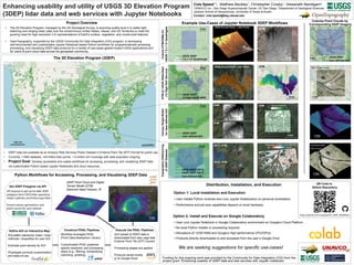
  • 1. https://registry.opendata.aws/usgs-lidar/ Funding for this ongoiing work was provided by the Community for Data Integration (CDI) from the project grant:“Enhancing usability of 3DEP data and web services with Jupyter notebooks • User installs Python modules and runs Jupyter Notebook(s) on personal workstation. • Performance and job size capabilities depend on local hardware. • User runs Jupyter Notebook in Google Colaboratory environment on Google’s Cloud Platform. • No local Python installs or processing required. • Allocations of 12GB RAM and Google’s high performance CPU/GPUs • Products directly downloaded to and accessed from the user’s Google Drive Enhancing usability and utility of USGS 3D Elevation Program (3DEP) lidar data and web services with Jupyter Notebooks Cole Speed1,3 , Matthew Beckley1 , Christopher Crosby1 , Viswanath Nandigam2 !"#$%&"&'()"*+ Contact: cole.speed@beg.utexas.edu 1 UNAVCO Inc.; San Diego Supercomputer Center, UC San Diego; 3 Department of Geological Sciences Jackson School of Geosciences, University of Texas at Austin 600 km • 3DEP data are available as an Amazon Web Services Public Dataset in Entwine Point Tile (EPT) format for public use. • Currently, >1800 datasets, >43 trillion lidar points, > 6 million km2 coverage with data acquistion ongoing. • Project Goal: Develop accessible and usable workflows for accessing, processing, and visualizing 3DEP data via customizable Python-based Jupyter Notebooks and cloud resources. The 3D Elevation Program (3DEP) ipyleaflet Project Overview • The 3D Elevation Program, managed by the US Geological Survey, is acquiring quality level 2 or better light detecting and ranging (lidar) data over the conterminous United States, Hawaii, and US Territories to meet the growing need for high-resolution 3-D representations of Earth's surface, vegetation, and constructed features. • OpenTopography, supported by the USGS Community for Data Integration (CDI) program, is developing well-documented and customizable Jupyter Notebook-based Python workflows for programmatically accessing, processing, and visualizing 3DEP data products for a variety of use-cases geared toward USGS applications and for users of point cloud data across the geospatial community. Example Use-Cases of Jupyter Notebook 3DEP Workflows z Distribution, Installation, and Execution Python Workflows for Accessing, Processing, and Visualizing 3DEP Data Lidar Point Cloud CHM DTM by USGS Watershed (12 Digit HUC Service) Cutsom DTM/DSMs for USGS 7.5 x 7.5’ Quadragles Canopy Height Model for User-defined AOI https://github.com/cmspeed/OT_3DEP_Workflows Topographic Differencing of 3DEP Datasets We are seeking suggestions for specific use-cases! USGS 3DEP 7.5 x 7.5’ Quadrangle DTM DTM Differenced DSM USGS 3DEP 12-Digit USGS WBD USGS 3DEP User-defined AOI USGS 3DEP (2013) USGS 3DEP (2011) User-defined AOI Lidar Point Cloud 5 km 5 km 5 km Colorize Point Clouds by Corresponding NAIP Imagery NAIP Image Service Correspoinding 3DEP Datset Colorized point clouds Text about querying 3DEP Colorized point clouds 1 km USGS 3DEP User-defined AOI 1 km 1 km 1 km 5 km 3 km DSM DTM Canopy Height (m) 0 5 2 km USGS Ground Class - Lidar Points 5 km USGS Ground Class - Lidar Points DTM 5 km Get 3DEP Polygons via API Construct PDAL Pipelines Execute the PDAL Pipelines Define AOI on Interactive Map API request to get up-to-date 3DEP polygons from USGS lidar repository (https://github.com/hobu/usgs-lidar) Extract names, geometries, and point counts for each dataset AOI subset of 3DEP data is downloaded from aws usgs-lidar Entwine Point Tile (EPT) bucket Processing stages are applied Products saved locally or to Google Drive Workflow leverages PDAL (Point Data Abstraction Library) Customizable PDAL pipelines: specify resolution and processing steps (e.g., filtering, reclassifying, colorizing, gridding) iPyLeaflet interactive maps / draw methods / shapefiles for user AOI Estimate point density for AOI iPywidgets promote customization and ease-of-use Option 2: Install and Execute on Google Colaboratory Option 1: Local Installation and Execution QR Code to Github Repository 2013 - DTM 2011 - DTM Topographic Difference (2013-2011) (m) -0.5 0.5 (m) 2 km 1 km 3DEP Point Cloud and Digital Terrain Model (DTM) Diamond Head Volcano, HI Colorized 3DEP Point cloud