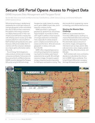
SlideShare a Scribd company logo
1 of 2
Download to read offline
 Project data is accessible via GEMS’ Pangaea GIS portal.
6 Esri News for Petroleum  Winter 2013/2014
GIS portal technology is rapidly being
adopted by the oil and gas industry to
manage geospatial content and extend
the value of GIS and data investments.
The appeal is that energy companies
can deploy these portals on their own
infrastructure behind the company fire-
wall, allowing users to access up-to-date
company data from a secure platform.
Staff members will quickly become users
because a GIS portal enables them to
interface with the company’s database
via a map to get to information vital to
their work.
	 Forum Energy Technologies pro-
vides products and services to energy
companies worldwide. Its business unit
Geoscience Earth and Marine Services
(GEMS) recently deployed the Pangaea
GIS portal using ArcGIS technology.
Secure GIS Portal Opens Access to Project Data
GEMS Improves Data Management with Pangaea Portal
By Tom Bell, Geoscience Earth and Marine Services; Todd Buehlman, LOGIC Solutions Group; and Orlando McDowelle,
LOGIC Solutions Group
Pangaea has made it easier for employ-
ees to get to GEMS’ project data, and it
saves the company money.
	 GEMS specializes in geological,
geophysical, geotechnical, and archaeo-
logical analyses. It provides its clients
with insight to address critical issues for
oil and gas exploration and develop-
ment, especially for subsea projects
and in complex environments such as
oceans and the Arctic. All its services are
geographic in nature, and it uses
Esri’s ArcGIS.
	 GEMS offers integrated geoscience
consulting and geotechnical engineer-
ing. It performs shallow water hazard
assessments by using 2D, 3D, and high-
resolution images. Its experts support
energy companies by planning studies
for field layout and pipeline routing. They
also provide Arctic engineering, marine
archaeology, and offshore field services.
Meeting the Massive Data
Challenge
GEMS has accumulated data from
more than 2,000 projects, resulting in a
massive file-based data store containing
more than 50 terabytes of information.
The store holds copious amounts of
documents, images, and supporting
information such as maps, seismic data,
side-scan sonar, cores, imagery, spread-
sheets, PDF files, Word documents, and
GIS data.
	 Staff members edit, store, and eventu-
ally electronically deliver this informa-
tion to GEMS’ clients worldwide. Prior
to launching its GIS portal, managing
the large file-based system presented
 The portal search tools include a spatial query and an
attribute query.
 High-performance OnBase
easily uploads a project’s
large data files.
7Winter 2013/2014  esri.com/petroleum
multiple challenges. Frequently, it was
difficult to locate data quickly from
previously completed projects. This
caused rework and data duplication. In
addition, the system could not search
the database using geographic attrib-
utes such as latitude and longitude or
an Outer Continental Shelf (OCS) lease
block. Without metadata, there was no
way to perform keyword searches for
documents. Moreover, once a document
was located, staff spent additional time
trying to determine if they had the final
version.
	 GEMS’ director Daniel Lanier initiated
the search for a state-of-the-art system.
He wanted a solution that would manage
and search for documents and perform
analyses via an intuitive map.
	 GEMS worked with LOGIC Solutions
Group to create the GIS-driven portal
GEMS Pangaea. Pangaea integrates spa-
tially aware document management and
search capabilities. It provides users with
intuitive, map-driven navigation of GEMS’
database and enables them to search,
view, and download and upload content.
	 Using Esri’s GIS technology, Hyland
Software’s OnBase content manage-
ment solution, and Microsoft’s Windows
Presentation Foundation (WPF) web
browser application, LOGIC’s develop-
ers designed an effective solution. The
Pangaea GIS portal fully leverages GEMS’
existing, heavily used GIS.
Elevating the User Experience
The user activates the search for docu-
ments via the map by clicking a point,
drawing a line or rectangle, or entering
coordinates. Search functionality rapidly
finds projects located within a selected
OCS lease block. Documents contain
geographic metadata as well as project
name, client name, and description,
which speeds up the search. LOGIC also
developed an application that allows
employees to search GEMS’ legacy file
system by client name, project name, or
file type.
	 Pangaea users view project boundaries
on a map and click a boundary to get
basic information about the project.
Within the interface, they can also search
and get a quick view of documents as-
sociated with that project.
	 Users upload documents to the docu-
ment management system and associate
the documents with projects. OnBase
allows users to upload large files to
the system including ArcGIS map files,
images, shapefiles, and other data as-
sociated with the project. They can also
upload documents to the data store from
outside the portal as well as download
data to a specific work environment.
	 The system prevents data duplication
during upload by flagging documents
that already exist in the system. When
the flag occurs, the user updates the
version of the existing document or adds
the appropriate metadata to associate
the document with additional projects.
By using OnBase with an Active Directory
tool, an administrator can control docu-
ment permissions, viewing, and down-
load throughout the enterprise.
	 The solution is easily learned. It has ex-
panded GEMS GIS as an enterprise busi-
ness application, which is a powerful tool
for managing projects and analyses. To
accomplish this task, LOGIC worked with
GEMS to provide an Esri and OnBase
solution that includes Esri ArcGIS for
Server and an OnBase enterprise content
management (ECM) solution.
Many Benefits
GEMS’ returns on its investment include
the following:
•• Reduced data search time. Using the
intuitive map search interface, staff
members now perform in a matter of
minutes the previously difficult, and
sometimes impossible, task of finding
projects completed near an OCS lease
block.
•• Increased confidence. Staff members
are assured that the version of the
analysis, data, or document being re-
viewed is up-to-date.
•• Eliminated data duplication.
•• Improved customer service. Staff mem-
bers quickly review historical analyses
in an area for a client.
Learn about GEMS at
f-e-t.com. To find out
more about the Pangaea
solution, contact Tom Bell
of GEMS at Tom.Bell@f-e-t
.com or 713-468-3705.
Case Study

More Related Content

Similar to GEMS_Article_PetroleumNews

World Pipelines - Better Together - SCADA and GIS
World Pipelines - Better Together - SCADA and GISWorld Pipelines - Better Together - SCADA and GIS
World Pipelines - Better Together - SCADA and GISsmrobb
 
The Underutilization of GIS technologies - Q&A with Shane Barrett
The Underutilization of GIS technologies - Q&A with Shane BarrettThe Underutilization of GIS technologies - Q&A with Shane Barrett
The Underutilization of GIS technologies - Q&A with Shane BarrettIQPC Australia
 
2018 GIS in the Rockies Vendor Showcase (Wed): Sharing Spatial Data Freely
2018 GIS in the Rockies Vendor Showcase (Wed): Sharing Spatial Data Freely2018 GIS in the Rockies Vendor Showcase (Wed): Sharing Spatial Data Freely
2018 GIS in the Rockies Vendor Showcase (Wed): Sharing Spatial Data FreelyGIS in the Rockies
 
MapGuide® OpenSource + iVAULT slim workflows, delivering web accessible mapping
MapGuide® OpenSource + iVAULT slim workflows, delivering web accessible mappingMapGuide® OpenSource + iVAULT slim workflows, delivering web accessible mapping
MapGuide® OpenSource + iVAULT slim workflows, delivering web accessible mappingeventspat
 
FlightlineGeo_ESRI_Newsletter_winter2014
FlightlineGeo_ESRI_Newsletter_winter2014FlightlineGeo_ESRI_Newsletter_winter2014
FlightlineGeo_ESRI_Newsletter_winter2014Devon Humphrey
 
React’s suitability to develop Geospatial solutions.pdf
React’s suitability to develop Geospatial solutions.pdfReact’s suitability to develop Geospatial solutions.pdf
React’s suitability to develop Geospatial solutions.pdfMindfire LLC
 
Gtkwebgis third ch_one_reduced
Gtkwebgis third ch_one_reducedGtkwebgis third ch_one_reduced
Gtkwebgis third ch_one_reducedKhadijaKhan52
 
An Intro to DI Geodata services
An Intro to DI Geodata servicesAn Intro to DI Geodata services
An Intro to DI Geodata servicesDrillinginfo
 
Getting your Data Out There: An Introduction to Distributed GIS
Getting your Data Out There:An Introduction to Distributed GISGetting your Data Out There:An Introduction to Distributed GIS
Getting your Data Out There: An Introduction to Distributed GISJohn Reiser
 
Field Data Collecting, Processing and Sharing: Using web Service Technologies
Field Data Collecting, Processing and Sharing: Using web Service TechnologiesField Data Collecting, Processing and Sharing: Using web Service Technologies
Field Data Collecting, Processing and Sharing: Using web Service TechnologiesNiroshan Sanjaya
 
Volume 2-issue-6-2030-2033
Volume 2-issue-6-2030-2033Volume 2-issue-6-2030-2033
Volume 2-issue-6-2030-2033Editor IJARCET
 
Volume 2-issue-6-2030-2033
Volume 2-issue-6-2030-2033Volume 2-issue-6-2030-2033
Volume 2-issue-6-2030-2033Editor IJARCET
 
Julie Rediker GIS Professional
Julie Rediker GIS ProfessionalJulie Rediker GIS Professional
Julie Rediker GIS ProfessionalJulie Rediker
 
GIS KNOWLEDGE SHARING: USING THE WEB FOR OPEN BUSINESS TO PROMOTE REGIONAL GI...
GIS KNOWLEDGE SHARING: USING THE WEB FOR OPEN BUSINESS TO PROMOTE REGIONAL GI...GIS KNOWLEDGE SHARING: USING THE WEB FOR OPEN BUSINESS TO PROMOTE REGIONAL GI...
GIS KNOWLEDGE SHARING: USING THE WEB FOR OPEN BUSINESS TO PROMOTE REGIONAL GI...Greg Babinski
 
TELUS Case Study: GIS for Telecommunications
TELUS Case Study: GIS for TelecommunicationsTELUS Case Study: GIS for Telecommunications
TELUS Case Study: GIS for Telecommunicationseventspat
 

Similar to GEMS_Article_PetroleumNews (20)

David Miller Retired
David Miller RetiredDavid Miller Retired
David Miller Retired
 
Geospatial Product Watch 2015
Geospatial Product Watch 2015Geospatial Product Watch 2015
Geospatial Product Watch 2015
 
World Pipelines - Better Together - SCADA and GIS
World Pipelines - Better Together - SCADA and GISWorld Pipelines - Better Together - SCADA and GIS
World Pipelines - Better Together - SCADA and GIS
 
The Underutilization of GIS technologies - Q&A with Shane Barrett
The Underutilization of GIS technologies - Q&A with Shane BarrettThe Underutilization of GIS technologies - Q&A with Shane Barrett
The Underutilization of GIS technologies - Q&A with Shane Barrett
 
Geosuiteonline EN
Geosuiteonline ENGeosuiteonline EN
Geosuiteonline EN
 
2018 GIS in the Rockies Vendor Showcase (Wed): Sharing Spatial Data Freely
2018 GIS in the Rockies Vendor Showcase (Wed): Sharing Spatial Data Freely2018 GIS in the Rockies Vendor Showcase (Wed): Sharing Spatial Data Freely
2018 GIS in the Rockies Vendor Showcase (Wed): Sharing Spatial Data Freely
 
MapGuide® OpenSource + iVAULT slim workflows, delivering web accessible mapping
MapGuide® OpenSource + iVAULT slim workflows, delivering web accessible mappingMapGuide® OpenSource + iVAULT slim workflows, delivering web accessible mapping
MapGuide® OpenSource + iVAULT slim workflows, delivering web accessible mapping
 
FlightlineGeo_ESRI_Newsletter_winter2014
FlightlineGeo_ESRI_Newsletter_winter2014FlightlineGeo_ESRI_Newsletter_winter2014
FlightlineGeo_ESRI_Newsletter_winter2014
 
React’s suitability to develop Geospatial solutions.pdf
React’s suitability to develop Geospatial solutions.pdfReact’s suitability to develop Geospatial solutions.pdf
React’s suitability to develop Geospatial solutions.pdf
 
HoLIS GIS Update
HoLIS GIS UpdateHoLIS GIS Update
HoLIS GIS Update
 
Gtkwebgis third ch_one_reduced
Gtkwebgis third ch_one_reducedGtkwebgis third ch_one_reduced
Gtkwebgis third ch_one_reduced
 
An Intro to DI Geodata services
An Intro to DI Geodata servicesAn Intro to DI Geodata services
An Intro to DI Geodata services
 
Getting your Data Out There: An Introduction to Distributed GIS
Getting your Data Out There:An Introduction to Distributed GISGetting your Data Out There:An Introduction to Distributed GIS
Getting your Data Out There: An Introduction to Distributed GIS
 
Field Data Collecting, Processing and Sharing: Using web Service Technologies
Field Data Collecting, Processing and Sharing: Using web Service TechnologiesField Data Collecting, Processing and Sharing: Using web Service Technologies
Field Data Collecting, Processing and Sharing: Using web Service Technologies
 
Volume 2-issue-6-2030-2033
Volume 2-issue-6-2030-2033Volume 2-issue-6-2030-2033
Volume 2-issue-6-2030-2033
 
Volume 2-issue-6-2030-2033
Volume 2-issue-6-2030-2033Volume 2-issue-6-2030-2033
Volume 2-issue-6-2030-2033
 
Julie Rediker GIS Professional
Julie Rediker GIS ProfessionalJulie Rediker GIS Professional
Julie Rediker GIS Professional
 
Earth Science Data and Information System (ESDIS) Project Update
Earth Science Data and Information System (ESDIS) Project UpdateEarth Science Data and Information System (ESDIS) Project Update
Earth Science Data and Information System (ESDIS) Project Update
 
GIS KNOWLEDGE SHARING: USING THE WEB FOR OPEN BUSINESS TO PROMOTE REGIONAL GI...
GIS KNOWLEDGE SHARING: USING THE WEB FOR OPEN BUSINESS TO PROMOTE REGIONAL GI...GIS KNOWLEDGE SHARING: USING THE WEB FOR OPEN BUSINESS TO PROMOTE REGIONAL GI...
GIS KNOWLEDGE SHARING: USING THE WEB FOR OPEN BUSINESS TO PROMOTE REGIONAL GI...
 
TELUS Case Study: GIS for Telecommunications
TELUS Case Study: GIS for TelecommunicationsTELUS Case Study: GIS for Telecommunications
TELUS Case Study: GIS for Telecommunications
 

GEMS_Article_PetroleumNews

  • 1.  Project data is accessible via GEMS’ Pangaea GIS portal. 6 Esri News for Petroleum  Winter 2013/2014 GIS portal technology is rapidly being adopted by the oil and gas industry to manage geospatial content and extend the value of GIS and data investments. The appeal is that energy companies can deploy these portals on their own infrastructure behind the company fire- wall, allowing users to access up-to-date company data from a secure platform. Staff members will quickly become users because a GIS portal enables them to interface with the company’s database via a map to get to information vital to their work. Forum Energy Technologies pro- vides products and services to energy companies worldwide. Its business unit Geoscience Earth and Marine Services (GEMS) recently deployed the Pangaea GIS portal using ArcGIS technology. Secure GIS Portal Opens Access to Project Data GEMS Improves Data Management with Pangaea Portal By Tom Bell, Geoscience Earth and Marine Services; Todd Buehlman, LOGIC Solutions Group; and Orlando McDowelle, LOGIC Solutions Group Pangaea has made it easier for employ- ees to get to GEMS’ project data, and it saves the company money. GEMS specializes in geological, geophysical, geotechnical, and archaeo- logical analyses. It provides its clients with insight to address critical issues for oil and gas exploration and develop- ment, especially for subsea projects and in complex environments such as oceans and the Arctic. All its services are geographic in nature, and it uses Esri’s ArcGIS. GEMS offers integrated geoscience consulting and geotechnical engineer- ing. It performs shallow water hazard assessments by using 2D, 3D, and high- resolution images. Its experts support energy companies by planning studies for field layout and pipeline routing. They also provide Arctic engineering, marine archaeology, and offshore field services. Meeting the Massive Data Challenge GEMS has accumulated data from more than 2,000 projects, resulting in a massive file-based data store containing more than 50 terabytes of information. The store holds copious amounts of documents, images, and supporting information such as maps, seismic data, side-scan sonar, cores, imagery, spread- sheets, PDF files, Word documents, and GIS data. Staff members edit, store, and eventu- ally electronically deliver this informa- tion to GEMS’ clients worldwide. Prior to launching its GIS portal, managing the large file-based system presented
  • 2.  The portal search tools include a spatial query and an attribute query.  High-performance OnBase easily uploads a project’s large data files. 7Winter 2013/2014  esri.com/petroleum multiple challenges. Frequently, it was difficult to locate data quickly from previously completed projects. This caused rework and data duplication. In addition, the system could not search the database using geographic attrib- utes such as latitude and longitude or an Outer Continental Shelf (OCS) lease block. Without metadata, there was no way to perform keyword searches for documents. Moreover, once a document was located, staff spent additional time trying to determine if they had the final version. GEMS’ director Daniel Lanier initiated the search for a state-of-the-art system. He wanted a solution that would manage and search for documents and perform analyses via an intuitive map. GEMS worked with LOGIC Solutions Group to create the GIS-driven portal GEMS Pangaea. Pangaea integrates spa- tially aware document management and search capabilities. It provides users with intuitive, map-driven navigation of GEMS’ database and enables them to search, view, and download and upload content. Using Esri’s GIS technology, Hyland Software’s OnBase content manage- ment solution, and Microsoft’s Windows Presentation Foundation (WPF) web browser application, LOGIC’s develop- ers designed an effective solution. The Pangaea GIS portal fully leverages GEMS’ existing, heavily used GIS. Elevating the User Experience The user activates the search for docu- ments via the map by clicking a point, drawing a line or rectangle, or entering coordinates. Search functionality rapidly finds projects located within a selected OCS lease block. Documents contain geographic metadata as well as project name, client name, and description, which speeds up the search. LOGIC also developed an application that allows employees to search GEMS’ legacy file system by client name, project name, or file type. Pangaea users view project boundaries on a map and click a boundary to get basic information about the project. Within the interface, they can also search and get a quick view of documents as- sociated with that project. Users upload documents to the docu- ment management system and associate the documents with projects. OnBase allows users to upload large files to the system including ArcGIS map files, images, shapefiles, and other data as- sociated with the project. They can also upload documents to the data store from outside the portal as well as download data to a specific work environment. The system prevents data duplication during upload by flagging documents that already exist in the system. When the flag occurs, the user updates the version of the existing document or adds the appropriate metadata to associate the document with additional projects. By using OnBase with an Active Directory tool, an administrator can control docu- ment permissions, viewing, and down- load throughout the enterprise. The solution is easily learned. It has ex- panded GEMS GIS as an enterprise busi- ness application, which is a powerful tool for managing projects and analyses. To accomplish this task, LOGIC worked with GEMS to provide an Esri and OnBase solution that includes Esri ArcGIS for Server and an OnBase enterprise content management (ECM) solution. Many Benefits GEMS’ returns on its investment include the following: •• Reduced data search time. Using the intuitive map search interface, staff members now perform in a matter of minutes the previously difficult, and sometimes impossible, task of finding projects completed near an OCS lease block. •• Increased confidence. Staff members are assured that the version of the analysis, data, or document being re- viewed is up-to-date. •• Eliminated data duplication. •• Improved customer service. Staff mem- bers quickly review historical analyses in an area for a client. Learn about GEMS at f-e-t.com. To find out more about the Pangaea solution, contact Tom Bell of GEMS at Tom.Bell@f-e-t .com or 713-468-3705. Case Study