SlideShare a Scribd company logo
Northern Plains Unmanned Systems Authority - North Dakota
• Research Focus – data linkages, human factors and
essential airworthiness data, and evaluating soil quality and crop
status in support of precision agriculture
• 2 year COA to fly a Draganflyer X4ES
University of Alaska Fairbanks
• Research Focus – airworthiness testing and system safety
requirements as well as wildlife location, identification and
counting
• 14 test ranges (7 in Alaska, 4 in Oregon and 3 in Hawaii)
• 2 year COA fto fly a Aeryon Scout
Nevada Institute for Autonomous Systems
• Research Focus – UAS standards and operations, operator
and certification requirements and evolution of air
traffic control procedures for integrating UAS into NextGen
• 2 year COA to fly Insitu ScanEagle at or below 3000 feet
Texas A&M University - Lone Star UAS Center
• Research Focus – airworthiness testing, system safety
requirements for UAS and operators, and command and
control link technologies
• 2 year COA to fly an AAAI RS-16 UAS
Griffiss International Airport (Rome, NY)
• Research Focus – Sense and avoidance in congested
airspace as well as imaging agriculture fields with different
sensors. Specific projects will focus on insects, weeds,
diseases, crop biomass, crop characteristics and
background soil characteristics
• 2 year CoA to fly PrecisionHawk’s Lancaster Hawkeye Mk III
at or below 400’
Virginia Tech - Mid-Atlantic Partnership
• Virginia, Maryland, and New Jersey test ranges
• Research Focus – agricultural spray equipment testing, development
of procedures for integration of UAS flights in a towered airspace and
developing training and operational procedures for aerial surveys of
agriculture
• 7 - 2 year COA’s
• UAS models include: Smart Road Flyer, eSPAARO, Aeryon Sky Ranger,
MANTRA2, Sig Rascal, and two AVID EDF-8 micro UAS’s
8/2014 - Continental Mapping Consultants Inc.

More Related Content

Similar to FAA UAS Map

NDGeospatialSummit2022 - UAS Lidar Mission Planning and Applications
NDGeospatialSummit2022 - UAS Lidar Mission Planning and ApplicationsNDGeospatialSummit2022 - UAS Lidar Mission Planning and Applications
NDGeospatialSummit2022 - UAS Lidar Mission Planning and Applications
North Dakota GIS Hub
 
AURA: Aerial Unpaved Roads Assessment System Demonstration - October 20, 2015
AURA: Aerial Unpaved Roads Assessment System Demonstration - October 20, 2015AURA: Aerial Unpaved Roads Assessment System Demonstration - October 20, 2015
AURA: Aerial Unpaved Roads Assessment System Demonstration - October 20, 2015
Michigan Tech Research Institute - AURA System
 
NASA Safety Case Approach for Automated Flight Authorization System
NASA Safety Case Approach for Automated Flight Authorization SystemNASA Safety Case Approach for Automated Flight Authorization System
NASA Safety Case Approach for Automated Flight Authorization System
Dr. Pankaj Dhussa
 
Drones
DronesDrones
Drones
Guada Casuso
 
The WMO AMDAR Observing System
The WMO AMDAR Observing SystemThe WMO AMDAR Observing System
The WMO AMDAR Observing System
bancha kaewngam
 
Remotely Piloted Aircraft Systems (RPAS)
Remotely Piloted Aircraft Systems (RPAS)Remotely Piloted Aircraft Systems (RPAS)
Remotely Piloted Aircraft Systems (RPAS)
ARDC
 
Johann Harich avionics tehcnician
Johann Harich avionics tehcnicianJohann Harich avionics tehcnician
Johann Harich avionics tehcnicianJohann Paul Harich
 
High Throughput Plant Phenotyping in Crop Improvement
High Throughput Plant Phenotyping in Crop ImprovementHigh Throughput Plant Phenotyping in Crop Improvement
High Throughput Plant Phenotyping in Crop Improvement
Khushbu
 
MASThesis_FutureOfMicroAerialVehicles
MASThesis_FutureOfMicroAerialVehiclesMASThesis_FutureOfMicroAerialVehicles
MASThesis_FutureOfMicroAerialVehiclesAstrid Thundercliffe
 
uav-presentation-precision-ag-slides.ppt
uav-presentation-precision-ag-slides.pptuav-presentation-precision-ag-slides.ppt
uav-presentation-precision-ag-slides.ppt
TESTFALTU
 
uav-presentation-precision-ag-slides.ppt
uav-presentation-precision-ag-slides.pptuav-presentation-precision-ag-slides.ppt
uav-presentation-precision-ag-slides.ppt
yomafi9978
 
The Use of GPS Tracking & Guidance Systems for the Chicken LIttle Joint Proje...
The Use of GPS Tracking & Guidance Systems for the Chicken LIttle Joint Proje...The Use of GPS Tracking & Guidance Systems for the Chicken LIttle Joint Proje...
The Use of GPS Tracking & Guidance Systems for the Chicken LIttle Joint Proje...Mark Hardesty
 
Summary Arun_Murthi Software System Safety SME
Summary Arun_Murthi Software System Safety SMESummary Arun_Murthi Software System Safety SME
Summary Arun_Murthi Software System Safety SMEARUN MURTHI
 
Douville Resume Generic
Douville Resume GenericDouville Resume Generic
Douville Resume GenericSean Douville
 
Summary Arun_Murthi Software System Safety SME
Summary Arun_Murthi Software System Safety SMESummary Arun_Murthi Software System Safety SME
Summary Arun_Murthi Software System Safety SMEARUN MURTHI
 
The Role of Unmanned Aircraft Systems in Natural Resource Management - Hutt
The Role of Unmanned Aircraft Systems in Natural Resource Management - HuttThe Role of Unmanned Aircraft Systems in Natural Resource Management - Hutt
The Role of Unmanned Aircraft Systems in Natural Resource Management - Hutt
Soil and Water Conservation Society
 
Unmanned Aircraft System Fundamentals
 Unmanned Aircraft System Fundamentals Unmanned Aircraft System Fundamentals
Unmanned Aircraft System Fundamentals
Jim Jenkins
 

Similar to FAA UAS Map (20)

NDGeospatialSummit2022 - UAS Lidar Mission Planning and Applications
NDGeospatialSummit2022 - UAS Lidar Mission Planning and ApplicationsNDGeospatialSummit2022 - UAS Lidar Mission Planning and Applications
NDGeospatialSummit2022 - UAS Lidar Mission Planning and Applications
 
ACJS Denver 2016 Presentation
ACJS Denver 2016 PresentationACJS Denver 2016 Presentation
ACJS Denver 2016 Presentation
 
RWhite Resume v15.2.
RWhite Resume v15.2.RWhite Resume v15.2.
RWhite Resume v15.2.
 
나야나
나야나나야나
나야나
 
AURA: Aerial Unpaved Roads Assessment System Demonstration - October 20, 2015
AURA: Aerial Unpaved Roads Assessment System Demonstration - October 20, 2015AURA: Aerial Unpaved Roads Assessment System Demonstration - October 20, 2015
AURA: Aerial Unpaved Roads Assessment System Demonstration - October 20, 2015
 
NASA Safety Case Approach for Automated Flight Authorization System
NASA Safety Case Approach for Automated Flight Authorization SystemNASA Safety Case Approach for Automated Flight Authorization System
NASA Safety Case Approach for Automated Flight Authorization System
 
Drones
DronesDrones
Drones
 
The WMO AMDAR Observing System
The WMO AMDAR Observing SystemThe WMO AMDAR Observing System
The WMO AMDAR Observing System
 
Remotely Piloted Aircraft Systems (RPAS)
Remotely Piloted Aircraft Systems (RPAS)Remotely Piloted Aircraft Systems (RPAS)
Remotely Piloted Aircraft Systems (RPAS)
 
Johann Harich avionics tehcnician
Johann Harich avionics tehcnicianJohann Harich avionics tehcnician
Johann Harich avionics tehcnician
 
High Throughput Plant Phenotyping in Crop Improvement
High Throughput Plant Phenotyping in Crop ImprovementHigh Throughput Plant Phenotyping in Crop Improvement
High Throughput Plant Phenotyping in Crop Improvement
 
MASThesis_FutureOfMicroAerialVehicles
MASThesis_FutureOfMicroAerialVehiclesMASThesis_FutureOfMicroAerialVehicles
MASThesis_FutureOfMicroAerialVehicles
 
uav-presentation-precision-ag-slides.ppt
uav-presentation-precision-ag-slides.pptuav-presentation-precision-ag-slides.ppt
uav-presentation-precision-ag-slides.ppt
 
uav-presentation-precision-ag-slides.ppt
uav-presentation-precision-ag-slides.pptuav-presentation-precision-ag-slides.ppt
uav-presentation-precision-ag-slides.ppt
 
The Use of GPS Tracking & Guidance Systems for the Chicken LIttle Joint Proje...
The Use of GPS Tracking & Guidance Systems for the Chicken LIttle Joint Proje...The Use of GPS Tracking & Guidance Systems for the Chicken LIttle Joint Proje...
The Use of GPS Tracking & Guidance Systems for the Chicken LIttle Joint Proje...
 
Summary Arun_Murthi Software System Safety SME
Summary Arun_Murthi Software System Safety SMESummary Arun_Murthi Software System Safety SME
Summary Arun_Murthi Software System Safety SME
 
Douville Resume Generic
Douville Resume GenericDouville Resume Generic
Douville Resume Generic
 
Summary Arun_Murthi Software System Safety SME
Summary Arun_Murthi Software System Safety SMESummary Arun_Murthi Software System Safety SME
Summary Arun_Murthi Software System Safety SME
 
The Role of Unmanned Aircraft Systems in Natural Resource Management - Hutt
The Role of Unmanned Aircraft Systems in Natural Resource Management - HuttThe Role of Unmanned Aircraft Systems in Natural Resource Management - Hutt
The Role of Unmanned Aircraft Systems in Natural Resource Management - Hutt
 
Unmanned Aircraft System Fundamentals
 Unmanned Aircraft System Fundamentals Unmanned Aircraft System Fundamentals
Unmanned Aircraft System Fundamentals
 

More from Continental Mapping Consultants

Continental Mapping Introduces TheGeoFoundry.com
Continental Mapping Introduces TheGeoFoundry.comContinental Mapping Introduces TheGeoFoundry.com
Continental Mapping Introduces TheGeoFoundry.com
Continental Mapping Consultants
 
Continental Mapping Projects - Wood Road Re-alignment
Continental Mapping Projects - Wood Road Re-alignmentContinental Mapping Projects - Wood Road Re-alignment
Continental Mapping Projects - Wood Road Re-alignment
Continental Mapping Consultants
 
Transportation Mapping
Transportation MappingTransportation Mapping
Transportation Mapping
Continental Mapping Consultants
 
Storygraphic - The Continental Mapping Story
Storygraphic - The Continental Mapping StoryStorygraphic - The Continental Mapping Story
Storygraphic - The Continental Mapping Story
Continental Mapping Consultants
 
Continental Mapping Projects - ATC Dane County
Continental Mapping Projects - ATC Dane CountyContinental Mapping Projects - ATC Dane County
Continental Mapping Projects - ATC Dane County
Continental Mapping Consultants
 
Continental Mapping Projects - USACE Cleveland Levee
Continental Mapping Projects - USACE Cleveland LeveeContinental Mapping Projects - USACE Cleveland Levee
Continental Mapping Projects - USACE Cleveland Levee
Continental Mapping Consultants
 
Continental Mapping Projects - USACE Pine Creek
Continental Mapping Projects - USACE Pine CreekContinental Mapping Projects - USACE Pine Creek
Continental Mapping Projects - USACE Pine Creek
Continental Mapping Consultants
 
Map America - 10 Tallest Dams Infographic
Map America - 10 Tallest Dams InfographicMap America - 10 Tallest Dams Infographic
Map America - 10 Tallest Dams Infographic
Continental Mapping Consultants
 
Continental Mapping Projects - Tualatin National Wildlife Refuge
Continental Mapping Projects - Tualatin National Wildlife RefugeContinental Mapping Projects - Tualatin National Wildlife Refuge
Continental Mapping Projects - Tualatin National Wildlife Refuge
Continental Mapping Consultants
 
Continental Mapping - On All Continents
Continental Mapping - On All Continents Continental Mapping - On All Continents
Continental Mapping - On All Continents
Continental Mapping Consultants
 
Red Wing Bridge Project
Red Wing Bridge ProjectRed Wing Bridge Project
Red Wing Bridge Project
Continental Mapping Consultants
 
Aztalan Project
Aztalan ProjectAztalan Project
Continental mapping projects las vegas water treatment plant
Continental mapping projects   las vegas water treatment plantContinental mapping projects   las vegas water treatment plant
Continental mapping projects las vegas water treatment plantContinental Mapping Consultants
 
Continental mapping projects indot south split
Continental mapping projects   indot south splitContinental mapping projects   indot south split
Continental mapping projects indot south split
Continental Mapping Consultants
 
Continental Mapping Projects - Dodger Stadium
Continental Mapping Projects - Dodger StadiumContinental Mapping Projects - Dodger Stadium
Continental Mapping Projects - Dodger Stadium
Continental Mapping Consultants
 
Continental Mapping Projects - Trans Design
Continental Mapping Projects - Trans DesignContinental Mapping Projects - Trans Design
Continental Mapping Projects - Trans Design
Continental Mapping Consultants
 

More from Continental Mapping Consultants (20)

Continental Mapping Introduces TheGeoFoundry.com
Continental Mapping Introduces TheGeoFoundry.comContinental Mapping Introduces TheGeoFoundry.com
Continental Mapping Introduces TheGeoFoundry.com
 
Continental Mapping Projects - Wood Road Re-alignment
Continental Mapping Projects - Wood Road Re-alignmentContinental Mapping Projects - Wood Road Re-alignment
Continental Mapping Projects - Wood Road Re-alignment
 
Transportation Mapping
Transportation MappingTransportation Mapping
Transportation Mapping
 
Storygraphic - The Continental Mapping Story
Storygraphic - The Continental Mapping StoryStorygraphic - The Continental Mapping Story
Storygraphic - The Continental Mapping Story
 
Continental Mapping Projects - ATC Dane County
Continental Mapping Projects - ATC Dane CountyContinental Mapping Projects - ATC Dane County
Continental Mapping Projects - ATC Dane County
 
Continental Mapping Projects - USACE Cleveland Levee
Continental Mapping Projects - USACE Cleveland LeveeContinental Mapping Projects - USACE Cleveland Levee
Continental Mapping Projects - USACE Cleveland Levee
 
Continental Mapping Projects - USACE Pine Creek
Continental Mapping Projects - USACE Pine CreekContinental Mapping Projects - USACE Pine Creek
Continental Mapping Projects - USACE Pine Creek
 
Map America - 10 Tallest Dams Infographic
Map America - 10 Tallest Dams InfographicMap America - 10 Tallest Dams Infographic
Map America - 10 Tallest Dams Infographic
 
Continental Mapping Projects - Chattanooga
Continental Mapping Projects - ChattanoogaContinental Mapping Projects - Chattanooga
Continental Mapping Projects - Chattanooga
 
Continental Mapping Projects - Tualatin National Wildlife Refuge
Continental Mapping Projects - Tualatin National Wildlife RefugeContinental Mapping Projects - Tualatin National Wildlife Refuge
Continental Mapping Projects - Tualatin National Wildlife Refuge
 
Continental Mapping - On All Continents
Continental Mapping - On All Continents Continental Mapping - On All Continents
Continental Mapping - On All Continents
 
Red Wing Bridge Project
Red Wing Bridge ProjectRed Wing Bridge Project
Red Wing Bridge Project
 
Aztalan Project
Aztalan ProjectAztalan Project
Aztalan Project
 
Continental Mapping Projects - FEMA Butler Co. MO
Continental Mapping Projects - FEMA Butler Co. MOContinental Mapping Projects - FEMA Butler Co. MO
Continental Mapping Projects - FEMA Butler Co. MO
 
Continental Mapping Projects - TDOT Grainger Co.
Continental Mapping Projects - TDOT Grainger Co.Continental Mapping Projects - TDOT Grainger Co.
Continental Mapping Projects - TDOT Grainger Co.
 
Continental mapping projects las vegas water treatment plant
Continental mapping projects   las vegas water treatment plantContinental mapping projects   las vegas water treatment plant
Continental mapping projects las vegas water treatment plant
 
Continental mapping projects indot south split
Continental mapping projects   indot south splitContinental mapping projects   indot south split
Continental mapping projects indot south split
 
Continental Mapping Projects - HWY F
Continental Mapping Projects - HWY FContinental Mapping Projects - HWY F
Continental Mapping Projects - HWY F
 
Continental Mapping Projects - Dodger Stadium
Continental Mapping Projects - Dodger StadiumContinental Mapping Projects - Dodger Stadium
Continental Mapping Projects - Dodger Stadium
 
Continental Mapping Projects - Trans Design
Continental Mapping Projects - Trans DesignContinental Mapping Projects - Trans Design
Continental Mapping Projects - Trans Design
 

Recently uploaded

nodule formation by alisha dewangan.pptx
nodule formation by alisha dewangan.pptxnodule formation by alisha dewangan.pptx
nodule formation by alisha dewangan.pptx
alishadewangan1
 
Shallowest Oil Discovery of Turkiye.pptx
Shallowest Oil Discovery of Turkiye.pptxShallowest Oil Discovery of Turkiye.pptx
Shallowest Oil Discovery of Turkiye.pptx
Gokturk Mehmet Dilci
 
ANAMOLOUS SECONDARY GROWTH IN DICOT ROOTS.pptx
ANAMOLOUS SECONDARY GROWTH IN DICOT ROOTS.pptxANAMOLOUS SECONDARY GROWTH IN DICOT ROOTS.pptx
ANAMOLOUS SECONDARY GROWTH IN DICOT ROOTS.pptx
RASHMI M G
 
Comparing Evolved Extractive Text Summary Scores of Bidirectional Encoder Rep...
Comparing Evolved Extractive Text Summary Scores of Bidirectional Encoder Rep...Comparing Evolved Extractive Text Summary Scores of Bidirectional Encoder Rep...
Comparing Evolved Extractive Text Summary Scores of Bidirectional Encoder Rep...
University of Maribor
 
Lateral Ventricles.pdf very easy good diagrams comprehensive
Lateral Ventricles.pdf very easy good diagrams comprehensiveLateral Ventricles.pdf very easy good diagrams comprehensive
Lateral Ventricles.pdf very easy good diagrams comprehensive
silvermistyshot
 
如何办理(uvic毕业证书)维多利亚大学毕业证本科学位证书原版一模一样
如何办理(uvic毕业证书)维多利亚大学毕业证本科学位证书原版一模一样如何办理(uvic毕业证书)维多利亚大学毕业证本科学位证书原版一模一样
如何办理(uvic毕业证书)维多利亚大学毕业证本科学位证书原版一模一样
yqqaatn0
 
What is greenhouse gasses and how many gasses are there to affect the Earth.
What is greenhouse gasses and how many gasses are there to affect the Earth.What is greenhouse gasses and how many gasses are there to affect the Earth.
What is greenhouse gasses and how many gasses are there to affect the Earth.
moosaasad1975
 
Salas, V. (2024) "John of St. Thomas (Poinsot) on the Science of Sacred Theol...
Salas, V. (2024) "John of St. Thomas (Poinsot) on the Science of Sacred Theol...Salas, V. (2024) "John of St. Thomas (Poinsot) on the Science of Sacred Theol...
Salas, V. (2024) "John of St. Thomas (Poinsot) on the Science of Sacred Theol...
Studia Poinsotiana
 
SAR of Medicinal Chemistry 1st by dk.pdf
SAR of Medicinal Chemistry 1st by dk.pdfSAR of Medicinal Chemistry 1st by dk.pdf
SAR of Medicinal Chemistry 1st by dk.pdf
KrushnaDarade1
 
DMARDs Pharmacolgy Pharm D 5th Semester.pdf
DMARDs Pharmacolgy Pharm D 5th Semester.pdfDMARDs Pharmacolgy Pharm D 5th Semester.pdf
DMARDs Pharmacolgy Pharm D 5th Semester.pdf
fafyfskhan251kmf
 
3D Hybrid PIC simulation of the plasma expansion (ISSS-14)
3D Hybrid PIC simulation of the plasma expansion (ISSS-14)3D Hybrid PIC simulation of the plasma expansion (ISSS-14)
3D Hybrid PIC simulation of the plasma expansion (ISSS-14)
David Osipyan
 
The use of Nauplii and metanauplii artemia in aquaculture (brine shrimp).pptx
The use of Nauplii and metanauplii artemia in aquaculture (brine shrimp).pptxThe use of Nauplii and metanauplii artemia in aquaculture (brine shrimp).pptx
The use of Nauplii and metanauplii artemia in aquaculture (brine shrimp).pptx
MAGOTI ERNEST
 
Orion Air Quality Monitoring Systems - CWS
Orion Air Quality Monitoring Systems - CWSOrion Air Quality Monitoring Systems - CWS
Orion Air Quality Monitoring Systems - CWS
Columbia Weather Systems
 
Travis Hills' Endeavors in Minnesota: Fostering Environmental and Economic Pr...
Travis Hills' Endeavors in Minnesota: Fostering Environmental and Economic Pr...Travis Hills' Endeavors in Minnesota: Fostering Environmental and Economic Pr...
Travis Hills' Endeavors in Minnesota: Fostering Environmental and Economic Pr...
Travis Hills MN
 
Leaf Initiation, Growth and Differentiation.pdf
Leaf Initiation, Growth and Differentiation.pdfLeaf Initiation, Growth and Differentiation.pdf
Leaf Initiation, Growth and Differentiation.pdf
RenuJangid3
 
Introduction to Mean Field Theory(MFT).pptx
Introduction to Mean Field Theory(MFT).pptxIntroduction to Mean Field Theory(MFT).pptx
Introduction to Mean Field Theory(MFT).pptx
zeex60
 
platelets_clotting_biogenesis.clot retractionpptx
platelets_clotting_biogenesis.clot retractionpptxplatelets_clotting_biogenesis.clot retractionpptx
platelets_clotting_biogenesis.clot retractionpptx
muralinath2
 
NuGOweek 2024 Ghent programme overview flyer
NuGOweek 2024 Ghent programme overview flyerNuGOweek 2024 Ghent programme overview flyer
NuGOweek 2024 Ghent programme overview flyer
pablovgd
 
Richard's aventures in two entangled wonderlands
Richard's aventures in two entangled wonderlandsRichard's aventures in two entangled wonderlands
Richard's aventures in two entangled wonderlands
Richard Gill
 
Remote Sensing and Computational, Evolutionary, Supercomputing, and Intellige...
Remote Sensing and Computational, Evolutionary, Supercomputing, and Intellige...Remote Sensing and Computational, Evolutionary, Supercomputing, and Intellige...
Remote Sensing and Computational, Evolutionary, Supercomputing, and Intellige...
University of Maribor
 

Recently uploaded (20)

nodule formation by alisha dewangan.pptx
nodule formation by alisha dewangan.pptxnodule formation by alisha dewangan.pptx
nodule formation by alisha dewangan.pptx
 
Shallowest Oil Discovery of Turkiye.pptx
Shallowest Oil Discovery of Turkiye.pptxShallowest Oil Discovery of Turkiye.pptx
Shallowest Oil Discovery of Turkiye.pptx
 
ANAMOLOUS SECONDARY GROWTH IN DICOT ROOTS.pptx
ANAMOLOUS SECONDARY GROWTH IN DICOT ROOTS.pptxANAMOLOUS SECONDARY GROWTH IN DICOT ROOTS.pptx
ANAMOLOUS SECONDARY GROWTH IN DICOT ROOTS.pptx
 
Comparing Evolved Extractive Text Summary Scores of Bidirectional Encoder Rep...
Comparing Evolved Extractive Text Summary Scores of Bidirectional Encoder Rep...Comparing Evolved Extractive Text Summary Scores of Bidirectional Encoder Rep...
Comparing Evolved Extractive Text Summary Scores of Bidirectional Encoder Rep...
 
Lateral Ventricles.pdf very easy good diagrams comprehensive
Lateral Ventricles.pdf very easy good diagrams comprehensiveLateral Ventricles.pdf very easy good diagrams comprehensive
Lateral Ventricles.pdf very easy good diagrams comprehensive
 
如何办理(uvic毕业证书)维多利亚大学毕业证本科学位证书原版一模一样
如何办理(uvic毕业证书)维多利亚大学毕业证本科学位证书原版一模一样如何办理(uvic毕业证书)维多利亚大学毕业证本科学位证书原版一模一样
如何办理(uvic毕业证书)维多利亚大学毕业证本科学位证书原版一模一样
 
What is greenhouse gasses and how many gasses are there to affect the Earth.
What is greenhouse gasses and how many gasses are there to affect the Earth.What is greenhouse gasses and how many gasses are there to affect the Earth.
What is greenhouse gasses and how many gasses are there to affect the Earth.
 
Salas, V. (2024) "John of St. Thomas (Poinsot) on the Science of Sacred Theol...
Salas, V. (2024) "John of St. Thomas (Poinsot) on the Science of Sacred Theol...Salas, V. (2024) "John of St. Thomas (Poinsot) on the Science of Sacred Theol...
Salas, V. (2024) "John of St. Thomas (Poinsot) on the Science of Sacred Theol...
 
SAR of Medicinal Chemistry 1st by dk.pdf
SAR of Medicinal Chemistry 1st by dk.pdfSAR of Medicinal Chemistry 1st by dk.pdf
SAR of Medicinal Chemistry 1st by dk.pdf
 
DMARDs Pharmacolgy Pharm D 5th Semester.pdf
DMARDs Pharmacolgy Pharm D 5th Semester.pdfDMARDs Pharmacolgy Pharm D 5th Semester.pdf
DMARDs Pharmacolgy Pharm D 5th Semester.pdf
 
3D Hybrid PIC simulation of the plasma expansion (ISSS-14)
3D Hybrid PIC simulation of the plasma expansion (ISSS-14)3D Hybrid PIC simulation of the plasma expansion (ISSS-14)
3D Hybrid PIC simulation of the plasma expansion (ISSS-14)
 
The use of Nauplii and metanauplii artemia in aquaculture (brine shrimp).pptx
The use of Nauplii and metanauplii artemia in aquaculture (brine shrimp).pptxThe use of Nauplii and metanauplii artemia in aquaculture (brine shrimp).pptx
The use of Nauplii and metanauplii artemia in aquaculture (brine shrimp).pptx
 
Orion Air Quality Monitoring Systems - CWS
Orion Air Quality Monitoring Systems - CWSOrion Air Quality Monitoring Systems - CWS
Orion Air Quality Monitoring Systems - CWS
 
Travis Hills' Endeavors in Minnesota: Fostering Environmental and Economic Pr...
Travis Hills' Endeavors in Minnesota: Fostering Environmental and Economic Pr...Travis Hills' Endeavors in Minnesota: Fostering Environmental and Economic Pr...
Travis Hills' Endeavors in Minnesota: Fostering Environmental and Economic Pr...
 
Leaf Initiation, Growth and Differentiation.pdf
Leaf Initiation, Growth and Differentiation.pdfLeaf Initiation, Growth and Differentiation.pdf
Leaf Initiation, Growth and Differentiation.pdf
 
Introduction to Mean Field Theory(MFT).pptx
Introduction to Mean Field Theory(MFT).pptxIntroduction to Mean Field Theory(MFT).pptx
Introduction to Mean Field Theory(MFT).pptx
 
platelets_clotting_biogenesis.clot retractionpptx
platelets_clotting_biogenesis.clot retractionpptxplatelets_clotting_biogenesis.clot retractionpptx
platelets_clotting_biogenesis.clot retractionpptx
 
NuGOweek 2024 Ghent programme overview flyer
NuGOweek 2024 Ghent programme overview flyerNuGOweek 2024 Ghent programme overview flyer
NuGOweek 2024 Ghent programme overview flyer
 
Richard's aventures in two entangled wonderlands
Richard's aventures in two entangled wonderlandsRichard's aventures in two entangled wonderlands
Richard's aventures in two entangled wonderlands
 
Remote Sensing and Computational, Evolutionary, Supercomputing, and Intellige...
Remote Sensing and Computational, Evolutionary, Supercomputing, and Intellige...Remote Sensing and Computational, Evolutionary, Supercomputing, and Intellige...
Remote Sensing and Computational, Evolutionary, Supercomputing, and Intellige...
 

FAA UAS Map

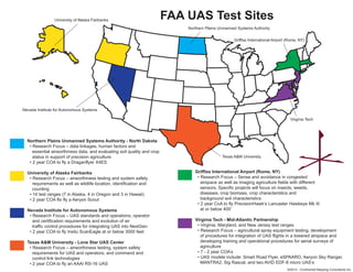
  • 1. Northern Plains Unmanned Systems Authority - North Dakota • Research Focus – data linkages, human factors and essential airworthiness data, and evaluating soil quality and crop status in support of precision agriculture • 2 year COA to fly a Draganflyer X4ES University of Alaska Fairbanks • Research Focus – airworthiness testing and system safety requirements as well as wildlife location, identification and counting • 14 test ranges (7 in Alaska, 4 in Oregon and 3 in Hawaii) • 2 year COA fto fly a Aeryon Scout Nevada Institute for Autonomous Systems • Research Focus – UAS standards and operations, operator and certification requirements and evolution of air traffic control procedures for integrating UAS into NextGen • 2 year COA to fly Insitu ScanEagle at or below 3000 feet Texas A&M University - Lone Star UAS Center • Research Focus – airworthiness testing, system safety requirements for UAS and operators, and command and control link technologies • 2 year COA to fly an AAAI RS-16 UAS Griffiss International Airport (Rome, NY) • Research Focus – Sense and avoidance in congested airspace as well as imaging agriculture fields with different sensors. Specific projects will focus on insects, weeds, diseases, crop biomass, crop characteristics and background soil characteristics • 2 year CoA to fly PrecisionHawk’s Lancaster Hawkeye Mk III at or below 400’ Virginia Tech - Mid-Atlantic Partnership • Virginia, Maryland, and New Jersey test ranges • Research Focus – agricultural spray equipment testing, development of procedures for integration of UAS flights in a towered airspace and developing training and operational procedures for aerial surveys of agriculture • 7 - 2 year COA’s • UAS models include: Smart Road Flyer, eSPAARO, Aeryon Sky Ranger, MANTRA2, Sig Rascal, and two AVID EDF-8 micro UAS’s 8/2014 - Continental Mapping Consultants Inc.