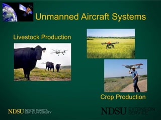
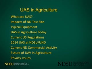
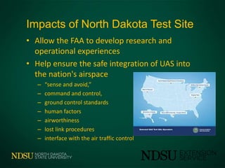
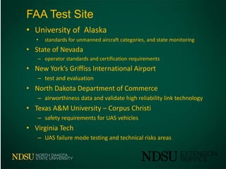
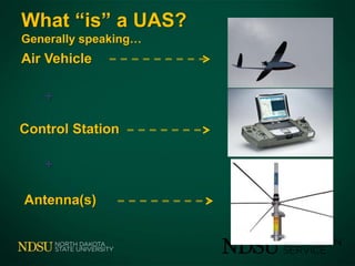
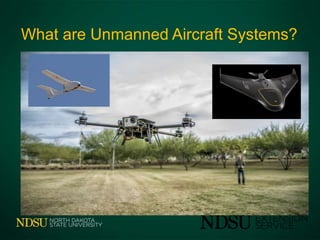
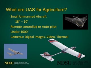
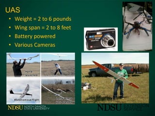
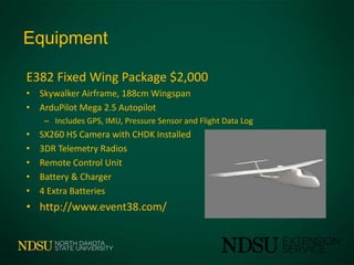
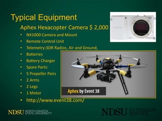
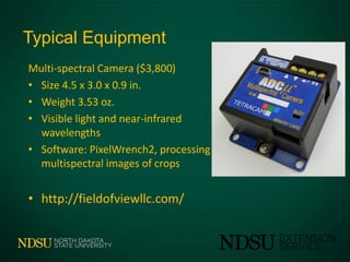
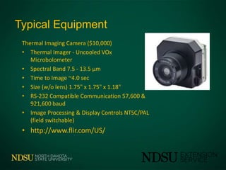
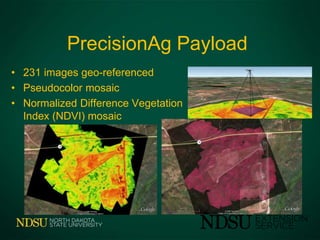
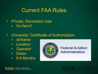
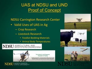
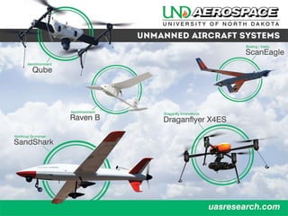
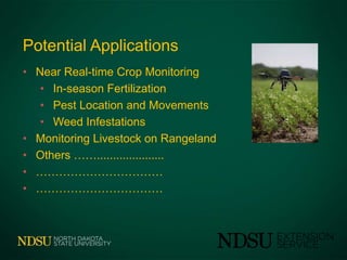
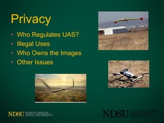
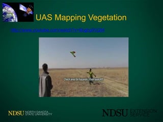
UAS in Agriculture
John Nowatzki
Extension Ag Machine Systems Specialist
Unmanned Aircraft Systems
Crop Production
Livestock Production
UAS in Agriculture
What are UAS?
Impacts of ND Test Site
Typical Equipment
UAS in Agriculture Today
Current US Regulations
2014 UAS at NDSU/UND
Current ND Commercial Activity
Future of UAV in Agriculture
Privacy Issues
Impacts of North Dakota Test Site
• Allow the FAA to develop research and
operational experiences
• Help ensure the safe integration of UAS into
the nation's airspace
– “sense and avoid,”
– command and control,
– ground control standards
– human factors
– airworthiness
– lost link procedures
– interface with the air traffic control
FAA Test Site
• University of Alaska
• standards for unmanned aircraft categories, and state monitoring
• State of Nevada
– operator standards and certification requirements
• New York’s Griffiss International Airport
– test and evaluation
• North Dakota Department of Commerce
– airworthiness data and validate high reliability link technology
• Texas A&M University – Corpus Christi
– safety requirements for UAS vehicles
• Virginia Tech
– UAS failure mode testing and technical risks areas
Air Vehicle
Control Station
Antenna(s)
+
+
What “is” a UAS?
Generally speaking…
What are Unmanned Aircraft Systems?
What
What are UAS for Agriculture?
Small Unmanned Aircraft
18” – 10’
Remote controlled or Auto-pilot
Under 1000’
Cameras: Digital Images, Video, Thermal
• Weight = 2 to 6 pounds
• Wing span = 2 to 8 feet
• Battery powered
• Various Cameras
UAS
Equipment
E382 Fixed Wing Package $2,000
• Skywalker Airframe, 188cm Wingspan
• ArduPilot Mega 2.5 Autopilot
– Includes GPS, IMU, Pressure Sensor and Flight Data Log
• SX260 HS Camera with CHDK Installed
• 3DR Telemetry Radios
• Remote Control Unit
• Battery & Charger
• 4 Extra Batteries
• http://www.event38.com/
Typical Equipment
Aphex Hexacopter Camera $ 2,000
• NX1000 Camera and Mount
• Remote Control Unit
• Telemetry:3DR Radios, Air and Ground,
• Batteries
• Battery Charger
• Spare Parts:
• 5 Propeller Pairs
• 2 Arms
• 2 Legs
• 1 Motor
• http://www.event38.com/
Typical Equipment
Aparotors - Kit: $3800
• Multi-rotor kit fully assembled
• Radio controller and receiver
• Stabilized Camera Gimbal
• 2 batteries (flight time 10 min / battery)
• Battery Charger (25 minutes)
• Camera GoPro3 with 8GB card
– http://aparotors.com/
Equipment
Precision Scout - Kit: $17,500
• Real-time live feed recorded and streamed to the ground
• GPS location and proper flight orientation
• communication fails, will safely return home
• •Controller •GPS Unit
• •Hi-resolution Video/Still Camera •Telemetry
• •Dual Battery Charger •6 Batteries
• •16gb micro SD memory card •Lifetime Protective Case
• http://aparotors.com/
Equipment
SensFly eBee Package $35,000
• Case with foam protection
• 1 eBee central body
• 1 pair of wings
• 10 spare propellers
• 2 Lithium-Polymer battery packs
• Lithium-Polymer battery charger
• 2.4 GHz USB radio modem
• 1 remote control
• 1 still camera
• 1 USB cable for interfacing with camera and on-board autopilot
https://www.sensefly.com/
Typical Equipment
Trimble UX5 Aerial Imaging Rover ($50,000)
• EPP foam; carbon frame structure
• Electric pusher propeller; brushless 700 W
motor
• 14.8 V, 6000 mAh battery
• 16.1 MP mirrorless APSC camera
• 0.94 - 9.4 in image resolution
http://www.trimble.com/Survey/ux5.aspx
Typical Equipment
Multi-spectral Camera ($3,800)
• Size 4.5 x 3.0 x 0.9 in.
• Weight 3.53 oz.
• Visible light and near-infrared
wavelengths
• Software: PixelWrench2, processing
multispectral images of crops
• http://fieldofviewllc.com/
Typical Equipment
Thermal Imaging Camera ($10,000)
• Thermal Imager - Uncooled VOx
Microbolometer
• Spectral Band 7.5 - 13.5 μm
• Time to Image ~4.0 sec
• Size (w/o lens) 1.75" x 1.75" x 1.18"
• RS-232 Compatible Communication 57,600 &
921,600 baud
• Image Processing & Display Controls NTSC/PAL
(field switchable)
• http://www.flir.com/US/
Thermal Imaging
Takes a Crop’s Temperature
Plants Absorb and Reflect Light Red Absorbed, NIR Reflected
• Locating insect
Infestations
• Early Disease Pressure
• Under-irrigated Field
Sections.
Multispectral Imaging
Plants Absorb and Reflect Light Red Absorbed, NIR Reflected
• 231 images geo-referenced
• Pseudocolor mosaic
• Normalized Difference Vegetation
Index (NDVI) mosaic
PrecisionAg Payload
Data Processing Software
Agisoft PhotoScan ($3,800)
• Aerial Triangulation
• Polygonal Model Generation (plain / textured)
• Setting Coordinate System
• Geo-referenced Digital Elevation Model (DEM)
Generation
• Geo-referenced Orthophoto Generation
• http://fieldofviewllc.com/
Current FAA Rules
• Private, Recreation Use
• On-farm?
• University: Certificate of Authorization
• Airframe
• Location
• Operator
• Dates
• 6-9 Months
NDSU Carrington Research Center
• Valid Uses of UAS in Ag
– Crop Research
– Livestock Research
• Feedlot Bedding Materials
• Animal Body Temperatures
UAS at NDSU and UND
Proof of Concept
NDSU – UND Collaborations
Agricultural Research School of Aerospace
Research Extension Centers UAS Center
Extension Service Remote Sensing
Commercial Service in 2014
• North Country Ag Services - Kris Poulson
– Contract to fly fields on schedule, or when requested
– Purchased UTC Aerospace Systems – will manufacture UAS
– Quad and Fixed wing
– Process data
• Field of View
– Cameras and Sensors
– Training
– Image Analyses
Potential Applications
• Near Real-time Crop Monitoring
• In-season Fertilization
• Pest Location and Movements
• Weed Infestations
• Monitoring Livestock on Rangeland
• Others …….....................
• ……………………………
• ……………………………
Privacy
• Who Regulates UAS?
• Illegal Uses
• Who Owns the Images
• Other Issues
Megan’s First UAS Operation
The End of Megan’s First UAS Operation!
UAS Mapping Vegetation
http://www.youtube.com/watch?v=6bgbp9Vj2t4
Questions - Comments
Office 701-231-8213 Cell 701-261-9842
John.Nowatzki@ndsu.edu
http://www.ag.ndsu.edu/agmachinery

UAS in agriculture 2-2014

  • 1.
    UAS in Agriculture JohnNowatzki Extension Ag Machine Systems Specialist
  • 2.
    Unmanned Aircraft Systems CropProduction Livestock Production
  • 3.
    UAS in Agriculture Whatare UAS? Impacts of ND Test Site Typical Equipment UAS in Agriculture Today Current US Regulations 2014 UAS at NDSU/UND Current ND Commercial Activity Future of UAV in Agriculture Privacy Issues
  • 4.
    Impacts of NorthDakota Test Site • Allow the FAA to develop research and operational experiences • Help ensure the safe integration of UAS into the nation's airspace – “sense and avoid,” – command and control, – ground control standards – human factors – airworthiness – lost link procedures – interface with the air traffic control
  • 5.
    FAA Test Site •University of Alaska • standards for unmanned aircraft categories, and state monitoring • State of Nevada – operator standards and certification requirements • New York’s Griffiss International Airport – test and evaluation • North Dakota Department of Commerce – airworthiness data and validate high reliability link technology • Texas A&M University – Corpus Christi – safety requirements for UAS vehicles • Virginia Tech – UAS failure mode testing and technical risks areas
  • 6.
    Air Vehicle Control Station Antenna(s) + + What“is” a UAS? Generally speaking…
  • 7.
    What are UnmannedAircraft Systems? What
  • 8.
    What are UASfor Agriculture? Small Unmanned Aircraft 18” – 10’ Remote controlled or Auto-pilot Under 1000’ Cameras: Digital Images, Video, Thermal
  • 9.
    • Weight =2 to 6 pounds • Wing span = 2 to 8 feet • Battery powered • Various Cameras UAS
  • 10.
    Equipment E382 Fixed WingPackage $2,000 • Skywalker Airframe, 188cm Wingspan • ArduPilot Mega 2.5 Autopilot – Includes GPS, IMU, Pressure Sensor and Flight Data Log • SX260 HS Camera with CHDK Installed • 3DR Telemetry Radios • Remote Control Unit • Battery & Charger • 4 Extra Batteries • http://www.event38.com/
  • 11.
    Typical Equipment Aphex HexacopterCamera $ 2,000 • NX1000 Camera and Mount • Remote Control Unit • Telemetry:3DR Radios, Air and Ground, • Batteries • Battery Charger • Spare Parts: • 5 Propeller Pairs • 2 Arms • 2 Legs • 1 Motor • http://www.event38.com/
  • 12.
    Typical Equipment Aparotors -Kit: $3800 • Multi-rotor kit fully assembled • Radio controller and receiver • Stabilized Camera Gimbal • 2 batteries (flight time 10 min / battery) • Battery Charger (25 minutes) • Camera GoPro3 with 8GB card – http://aparotors.com/
  • 13.
    Equipment Precision Scout -Kit: $17,500 • Real-time live feed recorded and streamed to the ground • GPS location and proper flight orientation • communication fails, will safely return home • •Controller •GPS Unit • •Hi-resolution Video/Still Camera •Telemetry • •Dual Battery Charger •6 Batteries • •16gb micro SD memory card •Lifetime Protective Case • http://aparotors.com/
  • 14.
    Equipment SensFly eBee Package$35,000 • Case with foam protection • 1 eBee central body • 1 pair of wings • 10 spare propellers • 2 Lithium-Polymer battery packs • Lithium-Polymer battery charger • 2.4 GHz USB radio modem • 1 remote control • 1 still camera • 1 USB cable for interfacing with camera and on-board autopilot https://www.sensefly.com/
  • 15.
    Typical Equipment Trimble UX5Aerial Imaging Rover ($50,000) • EPP foam; carbon frame structure • Electric pusher propeller; brushless 700 W motor • 14.8 V, 6000 mAh battery • 16.1 MP mirrorless APSC camera • 0.94 - 9.4 in image resolution http://www.trimble.com/Survey/ux5.aspx
  • 16.
    Typical Equipment Multi-spectral Camera($3,800) • Size 4.5 x 3.0 x 0.9 in. • Weight 3.53 oz. • Visible light and near-infrared wavelengths • Software: PixelWrench2, processing multispectral images of crops • http://fieldofviewllc.com/
  • 17.
    Typical Equipment Thermal ImagingCamera ($10,000) • Thermal Imager - Uncooled VOx Microbolometer • Spectral Band 7.5 - 13.5 μm • Time to Image ~4.0 sec • Size (w/o lens) 1.75" x 1.75" x 1.18" • RS-232 Compatible Communication 57,600 & 921,600 baud • Image Processing & Display Controls NTSC/PAL (field switchable) • http://www.flir.com/US/
  • 18.
    Thermal Imaging Takes aCrop’s Temperature Plants Absorb and Reflect Light Red Absorbed, NIR Reflected • Locating insect Infestations • Early Disease Pressure • Under-irrigated Field Sections.
  • 19.
    Multispectral Imaging Plants Absorband Reflect Light Red Absorbed, NIR Reflected
  • 20.
    • 231 imagesgeo-referenced • Pseudocolor mosaic • Normalized Difference Vegetation Index (NDVI) mosaic PrecisionAg Payload
  • 21.
    Data Processing Software AgisoftPhotoScan ($3,800) • Aerial Triangulation • Polygonal Model Generation (plain / textured) • Setting Coordinate System • Geo-referenced Digital Elevation Model (DEM) Generation • Geo-referenced Orthophoto Generation • http://fieldofviewllc.com/
  • 22.
    Current FAA Rules •Private, Recreation Use • On-farm? • University: Certificate of Authorization • Airframe • Location • Operator • Dates • 6-9 Months
  • 23.
    NDSU Carrington ResearchCenter • Valid Uses of UAS in Ag – Crop Research – Livestock Research • Feedlot Bedding Materials • Animal Body Temperatures UAS at NDSU and UND Proof of Concept
  • 24.
    NDSU – UNDCollaborations Agricultural Research School of Aerospace Research Extension Centers UAS Center Extension Service Remote Sensing
  • 26.
    Commercial Service in2014 • North Country Ag Services - Kris Poulson – Contract to fly fields on schedule, or when requested – Purchased UTC Aerospace Systems – will manufacture UAS – Quad and Fixed wing – Process data • Field of View – Cameras and Sensors – Training – Image Analyses
  • 27.
    Potential Applications • NearReal-time Crop Monitoring • In-season Fertilization • Pest Location and Movements • Weed Infestations • Monitoring Livestock on Rangeland • Others ……..................... • …………………………… • ……………………………
  • 28.
    Privacy • Who RegulatesUAS? • Illegal Uses • Who Owns the Images • Other Issues
  • 29.
  • 30.
    The End ofMegan’s First UAS Operation!
  • 31.
  • 32.
    Questions - Comments Office701-231-8213 Cell 701-261-9842 John.Nowatzki@ndsu.edu http://www.ag.ndsu.edu/agmachinery