SlideShare a Scribd company logo
1 of 1
Download to read offline
USACE Tulsa District Boundary Survey 
LOCATION: Pine Creek Lake, Oklahoma 
YEAR COMPLETED: 2011 
OBJECTIVE: High-accuracy mapping to support dam expansion 
KEY POINTS: 
• Complex topographic survey from aerial photogrammetry & land 
survey 
• Supported complex planning efforts for dam expansion 
• Delivered 90 days from receiving task order 
CONTINENTAL MAPPING 
Mapping from Earth, Sky and Space 
www.continentalmapping.com 
Madison, Wisconsin 
Indianapolis, Indiana 
Kansas City, Kansas 
St. Louis, Missouri 
Pine Creek Dam was constructed in 1969 with the primary purposes of 
controlling problematic flooding, providing drinking water, and providing 
recreation. Today Pine Creek is the site of an important retrofitting proj-ect. 
The Federal Energy Regulatory Commission issued a license (No. 
12646) to the city of Broken Bow, Oklahoma to add hydro power to this 
dam’s purposes. This work couldn’t start until USACE completes dam 
safety construction. 
Continental Mapping provided high-accuracy mapping of the Pine Creek 
dam, through our IDIQ master contract with the USACE Tulsa District. 
This area was approximately 620 acres and the data was used to sup-port 
development of a GIS suite with parcel mapping, land use, flood-plain, 
and wetland delineation. 
Aerial imagery was collected using 4 band, color, and direct digital 
imagery across the project site and required twenty-six photo control 
points. Continental Mapping provided the District with topographic 
and planimetric mapping, 1’ contours, and digital orthorectified 
imagery with 6” resolution. Planimetric mapping included curbs, 
paved and unpaved road, drives, sidewalks, buildings, manholes, catch basins, other 
visible utilities, poles, fences, vegetation, hydrology, and miscellaneous features 
visible in the imagery. The DTM supported a surface that met or exceeded ASPRS 
Class 1 accuracies.

More Related Content

What's hot

Operational Remote sensing Applications
Operational Remote sensing ApplicationsOperational Remote sensing Applications
Operational Remote sensing ApplicationsTushar Dholakia
 
Application of GIS in Modelling Landuse Changes Of Gurupavanapuri, Kerala, India
Application of GIS in Modelling Landuse Changes Of Gurupavanapuri, Kerala, IndiaApplication of GIS in Modelling Landuse Changes Of Gurupavanapuri, Kerala, India
Application of GIS in Modelling Landuse Changes Of Gurupavanapuri, Kerala, IndiaSharik Shamsudhien
 
Assessing polymetallic nodule deposit in the Cook Island EEZ
Assessing polymetallic nodule deposit in the Cook Island EEZAssessing polymetallic nodule deposit in the Cook Island EEZ
Assessing polymetallic nodule deposit in the Cook Island EEZKenex Ltd
 
Data preparation for Digital Soil Mapping
Data preparation for Digital Soil MappingData preparation for Digital Soil Mapping
Data preparation for Digital Soil MappingExternalEvents
 
MacDonald Dan Oct 1 2014 [1130 am Session A] TAC 2014 Montreal [Compat...
MacDonald Dan   Oct 1  2014 [1130 am  Session A]   TAC 2014  Montreal [Compat...MacDonald Dan   Oct 1  2014 [1130 am  Session A]   TAC 2014  Montreal [Compat...
MacDonald Dan Oct 1 2014 [1130 am Session A] TAC 2014 Montreal [Compat...Dan MacDonald, P.Eng.
 
LANDSLIDE HAZARD ZONATION MAPPING USING RS AND GIS
LANDSLIDE HAZARD ZONATION MAPPING USING RS AND GISLANDSLIDE HAZARD ZONATION MAPPING USING RS AND GIS
LANDSLIDE HAZARD ZONATION MAPPING USING RS AND GISAditya Ghumare
 
Soil mapping goes digital - the GlobalSoilMap experience by Alex. McBratney
Soil mapping goes digital - the GlobalSoilMap experience by Alex. McBratneySoil mapping goes digital - the GlobalSoilMap experience by Alex. McBratney
Soil mapping goes digital - the GlobalSoilMap experience by Alex. McBratneyFAO
 
2. virat arora, s. s. rao, e. amminedu and p. jagadeeswara rao
2. virat arora, s. s. rao, e. amminedu and p. jagadeeswara rao2. virat arora, s. s. rao, e. amminedu and p. jagadeeswara rao
2. virat arora, s. s. rao, e. amminedu and p. jagadeeswara raoJournal of Global Resources
 
“Cadastral Maps for Socio-Economic Data Visualization and Integration for Lan...
“Cadastral Maps for Socio-Economic Data Visualization and Integration for Lan...“Cadastral Maps for Socio-Economic Data Visualization and Integration for Lan...
“Cadastral Maps for Socio-Economic Data Visualization and Integration for Lan...irjes
 
Peatland monitoring iucn conference v.4
Peatland monitoring iucn conference v.4Peatland monitoring iucn conference v.4
Peatland monitoring iucn conference v.4Jeremy LeLean
 
Sea Level Rise & the Conservation of Wetlands: Issues and Opportunities for C...
Sea Level Rise & the Conservation of Wetlands: Issues and Opportunities for C...Sea Level Rise & the Conservation of Wetlands: Issues and Opportunities for C...
Sea Level Rise & the Conservation of Wetlands: Issues and Opportunities for C...riseagrant
 
Applied Geospatial Sciences Assignment
Applied Geospatial Sciences AssignmentApplied Geospatial Sciences Assignment
Applied Geospatial Sciences AssignmentJoshua Brunsdon
 
landslide hazard mapping in Ethiopia
landslide hazard mapping in Ethiopialandslide hazard mapping in Ethiopia
landslide hazard mapping in EthiopiaUniversity of Gondar
 
A GIS based framework for assessing and mapping potential irrigation areas in...
A GIS based framework for assessing and mapping potential irrigation areas in...A GIS based framework for assessing and mapping potential irrigation areas in...
A GIS based framework for assessing and mapping potential irrigation areas in...World Agroforestry (ICRAF)
 

What's hot (20)

Operational Remote sensing Applications
Operational Remote sensing ApplicationsOperational Remote sensing Applications
Operational Remote sensing Applications
 
Application of GIS in Modelling Landuse Changes Of Gurupavanapuri, Kerala, India
Application of GIS in Modelling Landuse Changes Of Gurupavanapuri, Kerala, IndiaApplication of GIS in Modelling Landuse Changes Of Gurupavanapuri, Kerala, India
Application of GIS in Modelling Landuse Changes Of Gurupavanapuri, Kerala, India
 
Assessing polymetallic nodule deposit in the Cook Island EEZ
Assessing polymetallic nodule deposit in the Cook Island EEZAssessing polymetallic nodule deposit in the Cook Island EEZ
Assessing polymetallic nodule deposit in the Cook Island EEZ
 
Data preparation for Digital Soil Mapping
Data preparation for Digital Soil MappingData preparation for Digital Soil Mapping
Data preparation for Digital Soil Mapping
 
50120140501011
5012014050101150120140501011
50120140501011
 
KFW - TAS Resume
KFW - TAS ResumeKFW - TAS Resume
KFW - TAS Resume
 
Frankovitch Resume-July 2015
Frankovitch Resume-July 2015Frankovitch Resume-July 2015
Frankovitch Resume-July 2015
 
MacDonald Dan Oct 1 2014 [1130 am Session A] TAC 2014 Montreal [Compat...
MacDonald Dan   Oct 1  2014 [1130 am  Session A]   TAC 2014  Montreal [Compat...MacDonald Dan   Oct 1  2014 [1130 am  Session A]   TAC 2014  Montreal [Compat...
MacDonald Dan Oct 1 2014 [1130 am Session A] TAC 2014 Montreal [Compat...
 
LANDSLIDE HAZARD ZONATION MAPPING USING RS AND GIS
LANDSLIDE HAZARD ZONATION MAPPING USING RS AND GISLANDSLIDE HAZARD ZONATION MAPPING USING RS AND GIS
LANDSLIDE HAZARD ZONATION MAPPING USING RS AND GIS
 
Soil mapping goes digital - the GlobalSoilMap experience by Alex. McBratney
Soil mapping goes digital - the GlobalSoilMap experience by Alex. McBratneySoil mapping goes digital - the GlobalSoilMap experience by Alex. McBratney
Soil mapping goes digital - the GlobalSoilMap experience by Alex. McBratney
 
2. virat arora, s. s. rao, e. amminedu and p. jagadeeswara rao
2. virat arora, s. s. rao, e. amminedu and p. jagadeeswara rao2. virat arora, s. s. rao, e. amminedu and p. jagadeeswara rao
2. virat arora, s. s. rao, e. amminedu and p. jagadeeswara rao
 
“Cadastral Maps for Socio-Economic Data Visualization and Integration for Lan...
“Cadastral Maps for Socio-Economic Data Visualization and Integration for Lan...“Cadastral Maps for Socio-Economic Data Visualization and Integration for Lan...
“Cadastral Maps for Socio-Economic Data Visualization and Integration for Lan...
 
KMac_CV_November 2016
KMac_CV_November 2016KMac_CV_November 2016
KMac_CV_November 2016
 
Peatland monitoring iucn conference v.4
Peatland monitoring iucn conference v.4Peatland monitoring iucn conference v.4
Peatland monitoring iucn conference v.4
 
Dam Removal Visualization
Dam Removal VisualizationDam Removal Visualization
Dam Removal Visualization
 
Sea Level Rise & the Conservation of Wetlands: Issues and Opportunities for C...
Sea Level Rise & the Conservation of Wetlands: Issues and Opportunities for C...Sea Level Rise & the Conservation of Wetlands: Issues and Opportunities for C...
Sea Level Rise & the Conservation of Wetlands: Issues and Opportunities for C...
 
Applied Geospatial Sciences Assignment
Applied Geospatial Sciences AssignmentApplied Geospatial Sciences Assignment
Applied Geospatial Sciences Assignment
 
landslide hazard mapping in Ethiopia
landslide hazard mapping in Ethiopialandslide hazard mapping in Ethiopia
landslide hazard mapping in Ethiopia
 
GIS APPLICATIONS & USES
GIS APPLICATIONS & USESGIS APPLICATIONS & USES
GIS APPLICATIONS & USES
 
A GIS based framework for assessing and mapping potential irrigation areas in...
A GIS based framework for assessing and mapping potential irrigation areas in...A GIS based framework for assessing and mapping potential irrigation areas in...
A GIS based framework for assessing and mapping potential irrigation areas in...
 

Viewers also liked

TH1.L09 - ADVANCES IN THE GENERATION OF DEFORMATION TIME SERIES FROM SAR DATA...
TH1.L09 - ADVANCES IN THE GENERATION OF DEFORMATION TIME SERIES FROM SAR DATA...TH1.L09 - ADVANCES IN THE GENERATION OF DEFORMATION TIME SERIES FROM SAR DATA...
TH1.L09 - ADVANCES IN THE GENERATION OF DEFORMATION TIME SERIES FROM SAR DATA...grssieee
 
9oct 3 wang1-reservoir bank slope
9oct 3 wang1-reservoir bank slope9oct 3 wang1-reservoir bank slope
9oct 3 wang1-reservoir bank slopeceriuniroma
 
Katse dam monitoring
Katse dam monitoringKatse dam monitoring
Katse dam monitoringCharles Home
 
Application of Structure-from-Motion Photogrammetry for Erosion Processes Mon...
Application of Structure-from-Motion Photogrammetry for Erosion Processes Mon...Application of Structure-from-Motion Photogrammetry for Erosion Processes Mon...
Application of Structure-from-Motion Photogrammetry for Erosion Processes Mon...imar-uniri
 
Laser scanning technology in civil engg
Laser scanning technology in civil enggLaser scanning technology in civil engg
Laser scanning technology in civil enggSurya C D
 
geotechnical failures of dam
geotechnical failures of damgeotechnical failures of dam
geotechnical failures of damsanthosh2121
 
Modern surveying techniques
Modern surveying techniquesModern surveying techniques
Modern surveying techniquesSunny Jaiswal
 
Advance surveying equipments
Advance surveying equipmentsAdvance surveying equipments
Advance surveying equipmentsSuryaom Tiwari
 
Surveying instruments
Surveying instrumentsSurveying instruments
Surveying instrumentsShanALi
 
Welcome to the presentation on ‘total station
Welcome to the presentation on ‘total stationWelcome to the presentation on ‘total station
Welcome to the presentation on ‘total stationShashank Javalagi
 
Basics Of Surveying
Basics Of SurveyingBasics Of Surveying
Basics Of Surveyingstooty s
 

Viewers also liked (19)

TH1.L09 - ADVANCES IN THE GENERATION OF DEFORMATION TIME SERIES FROM SAR DATA...
TH1.L09 - ADVANCES IN THE GENERATION OF DEFORMATION TIME SERIES FROM SAR DATA...TH1.L09 - ADVANCES IN THE GENERATION OF DEFORMATION TIME SERIES FROM SAR DATA...
TH1.L09 - ADVANCES IN THE GENERATION OF DEFORMATION TIME SERIES FROM SAR DATA...
 
9oct 3 wang1-reservoir bank slope
9oct 3 wang1-reservoir bank slope9oct 3 wang1-reservoir bank slope
9oct 3 wang1-reservoir bank slope
 
Continental Mapping Projects - Chattanooga
Continental Mapping Projects - ChattanoogaContinental Mapping Projects - Chattanooga
Continental Mapping Projects - Chattanooga
 
Continental Mapping Projects - USACE Cleveland Levee
Continental Mapping Projects - USACE Cleveland LeveeContinental Mapping Projects - USACE Cleveland Levee
Continental Mapping Projects - USACE Cleveland Levee
 
Katse dam monitoring
Katse dam monitoringKatse dam monitoring
Katse dam monitoring
 
GNSS Monitoring
GNSS MonitoringGNSS Monitoring
GNSS Monitoring
 
Application of Structure-from-Motion Photogrammetry for Erosion Processes Mon...
Application of Structure-from-Motion Photogrammetry for Erosion Processes Mon...Application of Structure-from-Motion Photogrammetry for Erosion Processes Mon...
Application of Structure-from-Motion Photogrammetry for Erosion Processes Mon...
 
Laser scanning technology in civil engg
Laser scanning technology in civil enggLaser scanning technology in civil engg
Laser scanning technology in civil engg
 
geotechnical failures of dam
geotechnical failures of damgeotechnical failures of dam
geotechnical failures of dam
 
Modern surveying techniques
Modern surveying techniquesModern surveying techniques
Modern surveying techniques
 
Advance surveying equipments
Advance surveying equipmentsAdvance surveying equipments
Advance surveying equipments
 
Surveying instruments
Surveying instrumentsSurveying instruments
Surveying instruments
 
Modern Surveying
Modern Surveying Modern Surveying
Modern Surveying
 
EDM and Total Stations
EDM and Total StationsEDM and Total Stations
EDM and Total Stations
 
Total station
Total stationTotal station
Total station
 
Welcome to the presentation on ‘total station
Welcome to the presentation on ‘total stationWelcome to the presentation on ‘total station
Welcome to the presentation on ‘total station
 
Modern Surveying Equipment Presentation
Modern Surveying Equipment PresentationModern Surveying Equipment Presentation
Modern Surveying Equipment Presentation
 
Basics Of Surveying
Basics Of SurveyingBasics Of Surveying
Basics Of Surveying
 
Surveying
Surveying Surveying
Surveying
 

Similar to Continental Mapping Projects - USACE Pine Creek

SOQ (Sample)
SOQ (Sample)SOQ (Sample)
SOQ (Sample)jcirone
 
Baron - Jamaica Bay Task Force Meeting 2 - 30Nov23.pdf
Baron - Jamaica Bay Task Force Meeting 2 - 30Nov23.pdfBaron - Jamaica Bay Task Force Meeting 2 - 30Nov23.pdf
Baron - Jamaica Bay Task Force Meeting 2 - 30Nov23.pdfecowatchers
 
Headings - 2014 issue 1
Headings - 2014 issue 1Headings - 2014 issue 1
Headings - 2014 issue 1Headings
 
Baron-Jamaica Bay Task force 17Nov22.pdf
Baron-Jamaica Bay Task force 17Nov22.pdfBaron-Jamaica Bay Task force 17Nov22.pdf
Baron-Jamaica Bay Task force 17Nov22.pdfecowatchers
 
Quander Road Outfall and Stream Restoration
Quander Road Outfall and Stream RestorationQuander Road Outfall and Stream Restoration
Quander Road Outfall and Stream RestorationFairfax County
 
Professional Geologist Work Experience
Professional Geologist Work ExperienceProfessional Geologist Work Experience
Professional Geologist Work ExperienceWilliamOlsenPG
 
Jamaica Bay Task Force2- 10May22.pdf
Jamaica Bay Task Force2- 10May22.pdfJamaica Bay Task Force2- 10May22.pdf
Jamaica Bay Task Force2- 10May22.pdfecowatchers
 
Thomas Midolo Senior Presentation
Thomas Midolo Senior PresentationThomas Midolo Senior Presentation
Thomas Midolo Senior PresentationThomas Midolo
 
NDGeospatialSummit2019 - Fishing for History: Use of Recreational Sonar to Cr...
NDGeospatialSummit2019 - Fishing for History: Use of Recreational Sonar to Cr...NDGeospatialSummit2019 - Fishing for History: Use of Recreational Sonar to Cr...
NDGeospatialSummit2019 - Fishing for History: Use of Recreational Sonar to Cr...North Dakota GIS Hub
 
Continental mapping projects las vegas water treatment plant
Continental mapping projects   las vegas water treatment plantContinental mapping projects   las vegas water treatment plant
Continental mapping projects las vegas water treatment plantContinental Mapping Consultants
 
Barnack Drive Outfall Restoration Project Completion
Barnack Drive Outfall Restoration Project CompletionBarnack Drive Outfall Restoration Project Completion
Barnack Drive Outfall Restoration Project CompletionFairfax County
 
Dredging and Disposal Site Reclamation at John Redmond Reservoir, Kansas
Dredging and Disposal Site Reclamation at John Redmond Reservoir, KansasDredging and Disposal Site Reclamation at John Redmond Reservoir, Kansas
Dredging and Disposal Site Reclamation at John Redmond Reservoir, KansasMatt Unruh
 
Army Corps of Engineers Report on Restoration Planning in Jamaica bay
Army Corps of Engineers Report on Restoration Planning in Jamaica bayArmy Corps of Engineers Report on Restoration Planning in Jamaica bay
Army Corps of Engineers Report on Restoration Planning in Jamaica bayecowatchers
 
Lenox Drive Outfall Restoration
Lenox Drive Outfall RestorationLenox Drive Outfall Restoration
Lenox Drive Outfall RestorationFairfax County
 

Similar to Continental Mapping Projects - USACE Pine Creek (20)

Continental Mapping Projects - FEMA Butler Co. MO
Continental Mapping Projects - FEMA Butler Co. MOContinental Mapping Projects - FEMA Butler Co. MO
Continental Mapping Projects - FEMA Butler Co. MO
 
SOQ (Sample)
SOQ (Sample)SOQ (Sample)
SOQ (Sample)
 
Baron - Jamaica Bay Task Force Meeting 2 - 30Nov23.pdf
Baron - Jamaica Bay Task Force Meeting 2 - 30Nov23.pdfBaron - Jamaica Bay Task Force Meeting 2 - 30Nov23.pdf
Baron - Jamaica Bay Task Force Meeting 2 - 30Nov23.pdf
 
Headings - 2014 issue 1
Headings - 2014 issue 1Headings - 2014 issue 1
Headings - 2014 issue 1
 
Continental Mapping Projects - HWY F
Continental Mapping Projects - HWY FContinental Mapping Projects - HWY F
Continental Mapping Projects - HWY F
 
Baron-Jamaica Bay Task force 17Nov22.pdf
Baron-Jamaica Bay Task force 17Nov22.pdfBaron-Jamaica Bay Task force 17Nov22.pdf
Baron-Jamaica Bay Task force 17Nov22.pdf
 
Wisconsins Great Lakes Shoreline Viewer
Wisconsins Great Lakes Shoreline ViewerWisconsins Great Lakes Shoreline Viewer
Wisconsins Great Lakes Shoreline Viewer
 
Quander Road Outfall and Stream Restoration
Quander Road Outfall and Stream RestorationQuander Road Outfall and Stream Restoration
Quander Road Outfall and Stream Restoration
 
Professional Geologist Work Experience
Professional Geologist Work ExperienceProfessional Geologist Work Experience
Professional Geologist Work Experience
 
Hawaii Pacific GIS Conference 2012: Disaster Management and Emergency Respons...
Hawaii Pacific GIS Conference 2012: Disaster Management and Emergency Respons...Hawaii Pacific GIS Conference 2012: Disaster Management and Emergency Respons...
Hawaii Pacific GIS Conference 2012: Disaster Management and Emergency Respons...
 
Jamaica Bay Task Force2- 10May22.pdf
Jamaica Bay Task Force2- 10May22.pdfJamaica Bay Task Force2- 10May22.pdf
Jamaica Bay Task Force2- 10May22.pdf
 
Thomas Midolo Senior Presentation
Thomas Midolo Senior PresentationThomas Midolo Senior Presentation
Thomas Midolo Senior Presentation
 
Continental Mapping Projects - Dodger Stadium
Continental Mapping Projects - Dodger StadiumContinental Mapping Projects - Dodger Stadium
Continental Mapping Projects - Dodger Stadium
 
NDGeospatialSummit2019 - Fishing for History: Use of Recreational Sonar to Cr...
NDGeospatialSummit2019 - Fishing for History: Use of Recreational Sonar to Cr...NDGeospatialSummit2019 - Fishing for History: Use of Recreational Sonar to Cr...
NDGeospatialSummit2019 - Fishing for History: Use of Recreational Sonar to Cr...
 
Continental mapping projects las vegas water treatment plant
Continental mapping projects   las vegas water treatment plantContinental mapping projects   las vegas water treatment plant
Continental mapping projects las vegas water treatment plant
 
Barnack Drive Outfall Restoration Project Completion
Barnack Drive Outfall Restoration Project CompletionBarnack Drive Outfall Restoration Project Completion
Barnack Drive Outfall Restoration Project Completion
 
Dredging and Disposal Site Reclamation at John Redmond Reservoir, Kansas
Dredging and Disposal Site Reclamation at John Redmond Reservoir, KansasDredging and Disposal Site Reclamation at John Redmond Reservoir, Kansas
Dredging and Disposal Site Reclamation at John Redmond Reservoir, Kansas
 
Army Corps of Engineers Report on Restoration Planning in Jamaica bay
Army Corps of Engineers Report on Restoration Planning in Jamaica bayArmy Corps of Engineers Report on Restoration Planning in Jamaica bay
Army Corps of Engineers Report on Restoration Planning in Jamaica bay
 
Hawaii Pacific GIS Conference 2012: Plenary Session Keynote - Positioning the...
Hawaii Pacific GIS Conference 2012: Plenary Session Keynote - Positioning the...Hawaii Pacific GIS Conference 2012: Plenary Session Keynote - Positioning the...
Hawaii Pacific GIS Conference 2012: Plenary Session Keynote - Positioning the...
 
Lenox Drive Outfall Restoration
Lenox Drive Outfall RestorationLenox Drive Outfall Restoration
Lenox Drive Outfall Restoration
 

More from Continental Mapping Consultants

Continental Mapping Projects - Tualatin National Wildlife Refuge
Continental Mapping Projects - Tualatin National Wildlife RefugeContinental Mapping Projects - Tualatin National Wildlife Refuge
Continental Mapping Projects - Tualatin National Wildlife RefugeContinental Mapping Consultants
 

More from Continental Mapping Consultants (19)

Continental Mapping Introduces TheGeoFoundry.com
Continental Mapping Introduces TheGeoFoundry.comContinental Mapping Introduces TheGeoFoundry.com
Continental Mapping Introduces TheGeoFoundry.com
 
Continental Mapping Projects - Wood Road Re-alignment
Continental Mapping Projects - Wood Road Re-alignmentContinental Mapping Projects - Wood Road Re-alignment
Continental Mapping Projects - Wood Road Re-alignment
 
Transportation Mapping
Transportation MappingTransportation Mapping
Transportation Mapping
 
Storygraphic - The Continental Mapping Story
Storygraphic - The Continental Mapping StoryStorygraphic - The Continental Mapping Story
Storygraphic - The Continental Mapping Story
 
Continental Mapping Projects - ATC Dane County
Continental Mapping Projects - ATC Dane CountyContinental Mapping Projects - ATC Dane County
Continental Mapping Projects - ATC Dane County
 
Map America - 10 Tallest Dams Infographic
Map America - 10 Tallest Dams InfographicMap America - 10 Tallest Dams Infographic
Map America - 10 Tallest Dams Infographic
 
Continental Mapping Projects - Tualatin National Wildlife Refuge
Continental Mapping Projects - Tualatin National Wildlife RefugeContinental Mapping Projects - Tualatin National Wildlife Refuge
Continental Mapping Projects - Tualatin National Wildlife Refuge
 
Continental Mapping - On All Continents
Continental Mapping - On All Continents Continental Mapping - On All Continents
Continental Mapping - On All Continents
 
FAA UAS Map
FAA UAS MapFAA UAS Map
FAA UAS Map
 
Red Wing Bridge Project
Red Wing Bridge ProjectRed Wing Bridge Project
Red Wing Bridge Project
 
Aztalan Project
Aztalan ProjectAztalan Project
Aztalan Project
 
Continental Mapping Projects - TDOT Grainger Co.
Continental Mapping Projects - TDOT Grainger Co.Continental Mapping Projects - TDOT Grainger Co.
Continental Mapping Projects - TDOT Grainger Co.
 
Continental mapping projects indot south split
Continental mapping projects   indot south splitContinental mapping projects   indot south split
Continental mapping projects indot south split
 
Continental Mapping Projects - Trans Design
Continental Mapping Projects - Trans DesignContinental Mapping Projects - Trans Design
Continental Mapping Projects - Trans Design
 
Mobile Lidar - Speed You Need
Mobile Lidar - Speed You NeedMobile Lidar - Speed You Need
Mobile Lidar - Speed You Need
 
Control for Mobile Lidar
Control for Mobile LidarControl for Mobile Lidar
Control for Mobile Lidar
 
Yukon Delta Refuge Infographic
Yukon Delta Refuge InfographicYukon Delta Refuge Infographic
Yukon Delta Refuge Infographic
 
Photogrammetry
PhotogrammetryPhotogrammetry
Photogrammetry
 
Data Fusion Menu
Data Fusion MenuData Fusion Menu
Data Fusion Menu
 

Recently uploaded

Structural Analysis and Design of Foundations: A Comprehensive Handbook for S...
Structural Analysis and Design of Foundations: A Comprehensive Handbook for S...Structural Analysis and Design of Foundations: A Comprehensive Handbook for S...
Structural Analysis and Design of Foundations: A Comprehensive Handbook for S...Dr.Costas Sachpazis
 
OSVC_Meta-Data based Simulation Automation to overcome Verification Challenge...
OSVC_Meta-Data based Simulation Automation to overcome Verification Challenge...OSVC_Meta-Data based Simulation Automation to overcome Verification Challenge...
OSVC_Meta-Data based Simulation Automation to overcome Verification Challenge...Soham Mondal
 
What are the advantages and disadvantages of membrane structures.pptx
What are the advantages and disadvantages of membrane structures.pptxWhat are the advantages and disadvantages of membrane structures.pptx
What are the advantages and disadvantages of membrane structures.pptxwendy cai
 
ZXCTN 5804 / ZTE PTN / ZTE POTN / ZTE 5804 PTN / ZTE POTN 5804 ( 100/200 GE Z...
ZXCTN 5804 / ZTE PTN / ZTE POTN / ZTE 5804 PTN / ZTE POTN 5804 ( 100/200 GE Z...ZXCTN 5804 / ZTE PTN / ZTE POTN / ZTE 5804 PTN / ZTE POTN 5804 ( 100/200 GE Z...
ZXCTN 5804 / ZTE PTN / ZTE POTN / ZTE 5804 PTN / ZTE POTN 5804 ( 100/200 GE Z...ZTE
 
Introduction to IEEE STANDARDS and its different types.pptx
Introduction to IEEE STANDARDS and its different types.pptxIntroduction to IEEE STANDARDS and its different types.pptx
Introduction to IEEE STANDARDS and its different types.pptxupamatechverse
 
IMPLICATIONS OF THE ABOVE HOLISTIC UNDERSTANDING OF HARMONY ON PROFESSIONAL E...
IMPLICATIONS OF THE ABOVE HOLISTIC UNDERSTANDING OF HARMONY ON PROFESSIONAL E...IMPLICATIONS OF THE ABOVE HOLISTIC UNDERSTANDING OF HARMONY ON PROFESSIONAL E...
IMPLICATIONS OF THE ABOVE HOLISTIC UNDERSTANDING OF HARMONY ON PROFESSIONAL E...RajaP95
 
Biology for Computer Engineers Course Handout.pptx
Biology for Computer Engineers Course Handout.pptxBiology for Computer Engineers Course Handout.pptx
Biology for Computer Engineers Course Handout.pptxDeepakSakkari2
 
Analog to Digital and Digital to Analog Converter
Analog to Digital and Digital to Analog ConverterAnalog to Digital and Digital to Analog Converter
Analog to Digital and Digital to Analog ConverterAbhinavSharma374939
 
(RIA) Call Girls Bhosari ( 7001035870 ) HI-Fi Pune Escorts Service
(RIA) Call Girls Bhosari ( 7001035870 ) HI-Fi Pune Escorts Service(RIA) Call Girls Bhosari ( 7001035870 ) HI-Fi Pune Escorts Service
(RIA) Call Girls Bhosari ( 7001035870 ) HI-Fi Pune Escorts Serviceranjana rawat
 
Porous Ceramics seminar and technical writing
Porous Ceramics seminar and technical writingPorous Ceramics seminar and technical writing
Porous Ceramics seminar and technical writingrakeshbaidya232001
 
Microscopic Analysis of Ceramic Materials.pptx
Microscopic Analysis of Ceramic Materials.pptxMicroscopic Analysis of Ceramic Materials.pptx
Microscopic Analysis of Ceramic Materials.pptxpurnimasatapathy1234
 
Software Development Life Cycle By Team Orange (Dept. of Pharmacy)
Software Development Life Cycle By  Team Orange (Dept. of Pharmacy)Software Development Life Cycle By  Team Orange (Dept. of Pharmacy)
Software Development Life Cycle By Team Orange (Dept. of Pharmacy)Suman Mia
 
College Call Girls Nashik Nehal 7001305949 Independent Escort Service Nashik
College Call Girls Nashik Nehal 7001305949 Independent Escort Service NashikCollege Call Girls Nashik Nehal 7001305949 Independent Escort Service Nashik
College Call Girls Nashik Nehal 7001305949 Independent Escort Service NashikCall Girls in Nagpur High Profile
 
(ANVI) Koregaon Park Call Girls Just Call 7001035870 [ Cash on Delivery ] Pun...
(ANVI) Koregaon Park Call Girls Just Call 7001035870 [ Cash on Delivery ] Pun...(ANVI) Koregaon Park Call Girls Just Call 7001035870 [ Cash on Delivery ] Pun...
(ANVI) Koregaon Park Call Girls Just Call 7001035870 [ Cash on Delivery ] Pun...ranjana rawat
 
(ANJALI) Dange Chowk Call Girls Just Call 7001035870 [ Cash on Delivery ] Pun...
(ANJALI) Dange Chowk Call Girls Just Call 7001035870 [ Cash on Delivery ] Pun...(ANJALI) Dange Chowk Call Girls Just Call 7001035870 [ Cash on Delivery ] Pun...
(ANJALI) Dange Chowk Call Girls Just Call 7001035870 [ Cash on Delivery ] Pun...ranjana rawat
 
High Profile Call Girls Nagpur Meera Call 7001035870 Meet With Nagpur Escorts
High Profile Call Girls Nagpur Meera Call 7001035870 Meet With Nagpur EscortsHigh Profile Call Girls Nagpur Meera Call 7001035870 Meet With Nagpur Escorts
High Profile Call Girls Nagpur Meera Call 7001035870 Meet With Nagpur EscortsCall Girls in Nagpur High Profile
 

Recently uploaded (20)

Structural Analysis and Design of Foundations: A Comprehensive Handbook for S...
Structural Analysis and Design of Foundations: A Comprehensive Handbook for S...Structural Analysis and Design of Foundations: A Comprehensive Handbook for S...
Structural Analysis and Design of Foundations: A Comprehensive Handbook for S...
 
OSVC_Meta-Data based Simulation Automation to overcome Verification Challenge...
OSVC_Meta-Data based Simulation Automation to overcome Verification Challenge...OSVC_Meta-Data based Simulation Automation to overcome Verification Challenge...
OSVC_Meta-Data based Simulation Automation to overcome Verification Challenge...
 
What are the advantages and disadvantages of membrane structures.pptx
What are the advantages and disadvantages of membrane structures.pptxWhat are the advantages and disadvantages of membrane structures.pptx
What are the advantages and disadvantages of membrane structures.pptx
 
ZXCTN 5804 / ZTE PTN / ZTE POTN / ZTE 5804 PTN / ZTE POTN 5804 ( 100/200 GE Z...
ZXCTN 5804 / ZTE PTN / ZTE POTN / ZTE 5804 PTN / ZTE POTN 5804 ( 100/200 GE Z...ZXCTN 5804 / ZTE PTN / ZTE POTN / ZTE 5804 PTN / ZTE POTN 5804 ( 100/200 GE Z...
ZXCTN 5804 / ZTE PTN / ZTE POTN / ZTE 5804 PTN / ZTE POTN 5804 ( 100/200 GE Z...
 
Introduction to IEEE STANDARDS and its different types.pptx
Introduction to IEEE STANDARDS and its different types.pptxIntroduction to IEEE STANDARDS and its different types.pptx
Introduction to IEEE STANDARDS and its different types.pptx
 
★ CALL US 9953330565 ( HOT Young Call Girls In Badarpur delhi NCR
★ CALL US 9953330565 ( HOT Young Call Girls In Badarpur delhi NCR★ CALL US 9953330565 ( HOT Young Call Girls In Badarpur delhi NCR
★ CALL US 9953330565 ( HOT Young Call Girls In Badarpur delhi NCR
 
IMPLICATIONS OF THE ABOVE HOLISTIC UNDERSTANDING OF HARMONY ON PROFESSIONAL E...
IMPLICATIONS OF THE ABOVE HOLISTIC UNDERSTANDING OF HARMONY ON PROFESSIONAL E...IMPLICATIONS OF THE ABOVE HOLISTIC UNDERSTANDING OF HARMONY ON PROFESSIONAL E...
IMPLICATIONS OF THE ABOVE HOLISTIC UNDERSTANDING OF HARMONY ON PROFESSIONAL E...
 
Call Us -/9953056974- Call Girls In Vikaspuri-/- Delhi NCR
Call Us -/9953056974- Call Girls In Vikaspuri-/- Delhi NCRCall Us -/9953056974- Call Girls In Vikaspuri-/- Delhi NCR
Call Us -/9953056974- Call Girls In Vikaspuri-/- Delhi NCR
 
Biology for Computer Engineers Course Handout.pptx
Biology for Computer Engineers Course Handout.pptxBiology for Computer Engineers Course Handout.pptx
Biology for Computer Engineers Course Handout.pptx
 
Analog to Digital and Digital to Analog Converter
Analog to Digital and Digital to Analog ConverterAnalog to Digital and Digital to Analog Converter
Analog to Digital and Digital to Analog Converter
 
(RIA) Call Girls Bhosari ( 7001035870 ) HI-Fi Pune Escorts Service
(RIA) Call Girls Bhosari ( 7001035870 ) HI-Fi Pune Escorts Service(RIA) Call Girls Bhosari ( 7001035870 ) HI-Fi Pune Escorts Service
(RIA) Call Girls Bhosari ( 7001035870 ) HI-Fi Pune Escorts Service
 
Porous Ceramics seminar and technical writing
Porous Ceramics seminar and technical writingPorous Ceramics seminar and technical writing
Porous Ceramics seminar and technical writing
 
Microscopic Analysis of Ceramic Materials.pptx
Microscopic Analysis of Ceramic Materials.pptxMicroscopic Analysis of Ceramic Materials.pptx
Microscopic Analysis of Ceramic Materials.pptx
 
Software Development Life Cycle By Team Orange (Dept. of Pharmacy)
Software Development Life Cycle By  Team Orange (Dept. of Pharmacy)Software Development Life Cycle By  Team Orange (Dept. of Pharmacy)
Software Development Life Cycle By Team Orange (Dept. of Pharmacy)
 
College Call Girls Nashik Nehal 7001305949 Independent Escort Service Nashik
College Call Girls Nashik Nehal 7001305949 Independent Escort Service NashikCollege Call Girls Nashik Nehal 7001305949 Independent Escort Service Nashik
College Call Girls Nashik Nehal 7001305949 Independent Escort Service Nashik
 
(ANVI) Koregaon Park Call Girls Just Call 7001035870 [ Cash on Delivery ] Pun...
(ANVI) Koregaon Park Call Girls Just Call 7001035870 [ Cash on Delivery ] Pun...(ANVI) Koregaon Park Call Girls Just Call 7001035870 [ Cash on Delivery ] Pun...
(ANVI) Koregaon Park Call Girls Just Call 7001035870 [ Cash on Delivery ] Pun...
 
Exploring_Network_Security_with_JA3_by_Rakesh Seal.pptx
Exploring_Network_Security_with_JA3_by_Rakesh Seal.pptxExploring_Network_Security_with_JA3_by_Rakesh Seal.pptx
Exploring_Network_Security_with_JA3_by_Rakesh Seal.pptx
 
(ANJALI) Dange Chowk Call Girls Just Call 7001035870 [ Cash on Delivery ] Pun...
(ANJALI) Dange Chowk Call Girls Just Call 7001035870 [ Cash on Delivery ] Pun...(ANJALI) Dange Chowk Call Girls Just Call 7001035870 [ Cash on Delivery ] Pun...
(ANJALI) Dange Chowk Call Girls Just Call 7001035870 [ Cash on Delivery ] Pun...
 
9953056974 Call Girls In South Ex, Escorts (Delhi) NCR.pdf
9953056974 Call Girls In South Ex, Escorts (Delhi) NCR.pdf9953056974 Call Girls In South Ex, Escorts (Delhi) NCR.pdf
9953056974 Call Girls In South Ex, Escorts (Delhi) NCR.pdf
 
High Profile Call Girls Nagpur Meera Call 7001035870 Meet With Nagpur Escorts
High Profile Call Girls Nagpur Meera Call 7001035870 Meet With Nagpur EscortsHigh Profile Call Girls Nagpur Meera Call 7001035870 Meet With Nagpur Escorts
High Profile Call Girls Nagpur Meera Call 7001035870 Meet With Nagpur Escorts
 

Continental Mapping Projects - USACE Pine Creek

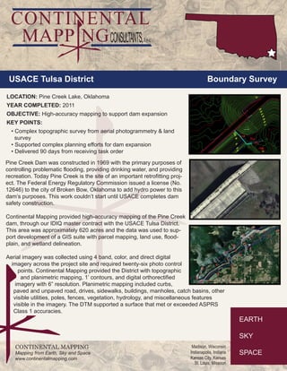
  • 1. USACE Tulsa District Boundary Survey LOCATION: Pine Creek Lake, Oklahoma YEAR COMPLETED: 2011 OBJECTIVE: High-accuracy mapping to support dam expansion KEY POINTS: • Complex topographic survey from aerial photogrammetry & land survey • Supported complex planning efforts for dam expansion • Delivered 90 days from receiving task order CONTINENTAL MAPPING Mapping from Earth, Sky and Space www.continentalmapping.com Madison, Wisconsin Indianapolis, Indiana Kansas City, Kansas St. Louis, Missouri Pine Creek Dam was constructed in 1969 with the primary purposes of controlling problematic flooding, providing drinking water, and providing recreation. Today Pine Creek is the site of an important retrofitting proj-ect. The Federal Energy Regulatory Commission issued a license (No. 12646) to the city of Broken Bow, Oklahoma to add hydro power to this dam’s purposes. This work couldn’t start until USACE completes dam safety construction. Continental Mapping provided high-accuracy mapping of the Pine Creek dam, through our IDIQ master contract with the USACE Tulsa District. This area was approximately 620 acres and the data was used to sup-port development of a GIS suite with parcel mapping, land use, flood-plain, and wetland delineation. Aerial imagery was collected using 4 band, color, and direct digital imagery across the project site and required twenty-six photo control points. Continental Mapping provided the District with topographic and planimetric mapping, 1’ contours, and digital orthorectified imagery with 6” resolution. Planimetric mapping included curbs, paved and unpaved road, drives, sidewalks, buildings, manholes, catch basins, other visible utilities, poles, fences, vegetation, hydrology, and miscellaneous features visible in the imagery. The DTM supported a surface that met or exceeded ASPRS Class 1 accuracies.