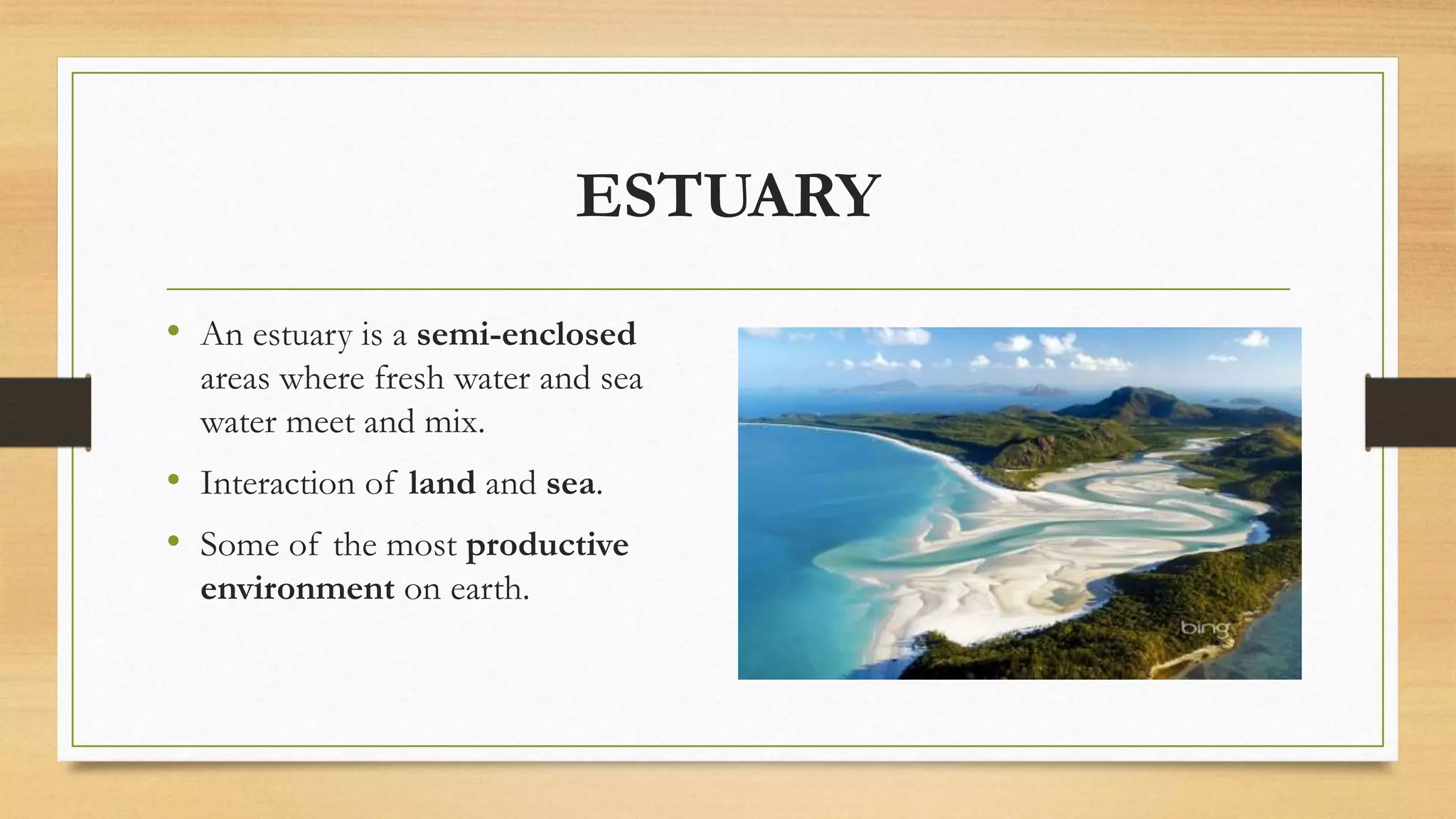
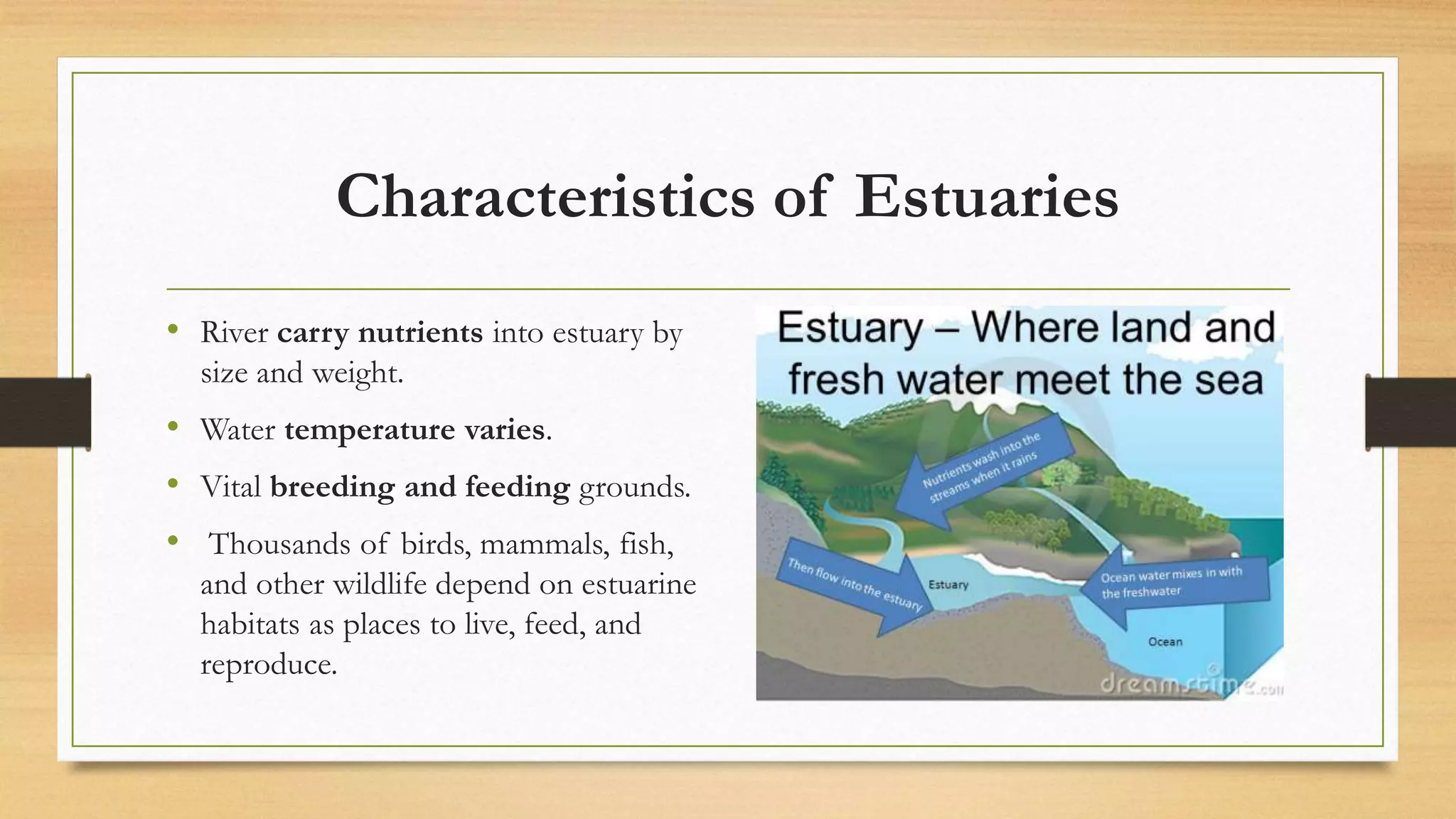
ESTUARIES
in
BANGLADESH
Presented by:
Tarikul Islam
Md. Abu Zafar
ESTUARY
• An estuary is a semi-enclosed
areas where fresh water and sea
water meet and mix.
• Interaction of land and sea.
• Some of the most productive
environment on earth.
Characteristics of Estuaries
• River carry nutrients into estuary by
size and weight.
• Water temperature varies.
• Vital breeding and feeding grounds.
• Thousands of birds, mammals, fish,
and other wildlife depend on estuarine
habitats as places to live, feed, and
reproduce.
Estuaries in in Bangladesh
• In our country more than 15 estuary.
• Now we discuss some importan
estuary. These are:
1. Karnaphuli river estuary.
2. Bakkhali river estuary.
3. Sundarbans estuary.
4. Naf river estuary
5. Meghna river estuary
Karnafuli River Estuary
• The largest and most important river in
Chittagong and the Chittagong Hill Tracts,
originating the Lushai hills in Mizoram
State of India.
• It is located between latitude 22°53′N
and longitude 91°47′E near Patenga in
Chittagong city.
• It is also an important navigational route
and Chittagong port is situated just 16.89
km above from the Bay of Bengal
Average values of physio-chemical
parameters
Species Abundance
• Total of 133 individual of fin
fishes were collected whics
represent 41 species.
• The total abundance of
- 17 species are found in post-
monsoon period
-31 species are found in
monsoon period
Bakkhali River Estuary
• Bakkhali River estuary is located in
Cox's Bazar District
• The Latitude of Bakkhali River is
21°46′N
• The Longitude of Bakkhali Rive is
91°96′E
Mean of Different Environmental
Parameter
Species Abundance
• 5 species of mangroves,
• 2 species of salt marsh plants,
• 1 species of seagrass,
• 3 species of macro-algae ,and
• Total of 93 individual fishes were
collected whics represent 21 species.
• 1 species of mangrove associate were
recorded from the intertidal area of
Bakkhali river estuary
List of the Macrophytes Recorded from the
Bakkhali river Estuary
Group Species
Mangroves Avicennia alba
A.marina
Mangroves associates Suaeda maritima
Saltmarsh Imperata cylindrical
Macro algae Hypnea sp
Catenella nipae
Sundarbans Estuary
• The largest single block of tidal
halophytic mangrove forest in the world.
• It lies on the Ganges-Brahmaputra delta
at the point where it
merges with the Bay of Bengal.
• The Latitude is 21°30′N
• The Longitud is 89°55′E
• Vital breeding and feeding grounds.
Main Feature of Sundarbans Estuary
Title Feature
Geology Sediments formed due to soil erosion in the Himalayas
Climate It is classified as tropical moist forest.
Vegation Recorded 334 species under 245 genera.
• Of the50 true mangrove plant species recorded .
Flora and
Fauna
• A total 245 genera and 334 plant species were recorded
• 150 species of commercially important fish,
• 270 species of bird
• 42 species of mammals, 35 reptiles and 8 amphibian species
Values of physio-chemical parameters
Parameter Amount
Temperature 26 - 28
pH 6.5 – 8.5
Salinity 6.2 – 19.5
DO 3.8 – 4.9
Transparency 23 -28 cm
Naf River Estuary
• Naf River estuary is located in Cox's
Bazar District
• The Latitude of Bakkhali River is
20°91′N
• The Longitude of Bakkhali Rive is
92°27′E
• Different types of birds, mammals,
fish, and other wildlife depend on this
estuarine habitats as places to live,
feed, and reproduce.
Values of Average physical-chemical
parameters
Parameter Amount
Temperature 22 - 27
Salinity 12 - 22
pH 7 – 8.5
Species Abundance
• A total 53 plant species were recorded
• 70 -75 species of commercially
important fish,
• 170 species of bird
• 32 species of mammals,
• 25 reptiles and
• 8 amphibian species
Meghna Estuary
• Meghna Estuary system is a very dynamic
estuarine and coastal system.
• Meghna estuary system appears to be a
funnel which consist of the Lower Meghna
River between Chandpur and the northern
head of Bhola,
• The Shahbazpur Channel between Bhola and
Hatia, the Tetulia River west of Bhola, and
the Hatia Channel north and east of Hatia.
• The Latitude of Meghna river is 22°50′N
• The Longitude of Bakkhali Rive is 90°83′E
Meghna Estuarine Morphology
• A vast network of rivers,
• An enormous discharge of river water
heavily laden with sediment, both
suspended and siltation load.
• The Swatch of No- Ground running
North east-South west partially
across the continental shelf about 24
km south of the Bangladesh coasta
funnel shaped, shallow and wide
estuary
Continued…
• A gently sloping wide continental
shelf
• A narrow strip of coastal
• Landforms fronting hill ranges strong
tidal actions
• Frequent landfall of tropical
cyclones.
• A large number of off-shore islands
and sand bars.
Physical and chemical Parameters:
Parameter Amount
Temperature 20 - 30
Salinity 20 – 28 ppt
pH 7 – 7.5
DO (mg/l) 3.5 – 4. 15
Species Abundance
• A total of 107 fish species belonging to 13
orders and 26 families were documented.
• Perciformes (32%)
• Siluriformes (29%),
• Cyprinidae (16%)
• Clupeiformes (8%)
• Synbranchiformes (3%)
• Pleuronectiformes, Anguiliformes,
Osteoglossiformes and Beloniformes
comprised 2%
Importance of Estuary:
• Critical for the survival of many species
• Fish and shellfish rely on the sheltered
waters of estuaries as protected places to
spawn, giving estuaries the nickname
“nurseries of the sea.”
• Plants and soils also act as a natural buffer
between the land and ocean, absorbing
flood waters and dissipating storm surges
Continued..
• Birds, mammals, fish, and other wildlife
depend on estuarine habitats as places to
live, feed, and reproduce.
• Plants and soils also act as a natural
buffer between the land and ocean,
absorbing flood waters and dissipating
storm surges
• Water draining from the uplands carries
sediments, nutrients, and other pollutants
Estuaries in Bangladesh

Estuaries in Bangladesh

  • 1.
  • 2.
    ESTUARY • An estuaryis a semi-enclosed areas where fresh water and sea water meet and mix. • Interaction of land and sea. • Some of the most productive environment on earth.
  • 3.
    Characteristics of Estuaries •River carry nutrients into estuary by size and weight. • Water temperature varies. • Vital breeding and feeding grounds. • Thousands of birds, mammals, fish, and other wildlife depend on estuarine habitats as places to live, feed, and reproduce.
  • 4.
    Estuaries in inBangladesh • In our country more than 15 estuary. • Now we discuss some importan estuary. These are: 1. Karnaphuli river estuary. 2. Bakkhali river estuary. 3. Sundarbans estuary. 4. Naf river estuary 5. Meghna river estuary
  • 5.
    Karnafuli River Estuary •The largest and most important river in Chittagong and the Chittagong Hill Tracts, originating the Lushai hills in Mizoram State of India. • It is located between latitude 22°53′N and longitude 91°47′E near Patenga in Chittagong city. • It is also an important navigational route and Chittagong port is situated just 16.89 km above from the Bay of Bengal
  • 6.
    Average values ofphysio-chemical parameters
  • 7.
    Species Abundance • Totalof 133 individual of fin fishes were collected whics represent 41 species. • The total abundance of - 17 species are found in post- monsoon period -31 species are found in monsoon period
  • 8.
    Bakkhali River Estuary •Bakkhali River estuary is located in Cox's Bazar District • The Latitude of Bakkhali River is 21°46′N • The Longitude of Bakkhali Rive is 91°96′E
  • 9.
    Mean of DifferentEnvironmental Parameter
  • 10.
    Species Abundance • 5species of mangroves, • 2 species of salt marsh plants, • 1 species of seagrass, • 3 species of macro-algae ,and • Total of 93 individual fishes were collected whics represent 21 species. • 1 species of mangrove associate were recorded from the intertidal area of Bakkhali river estuary
  • 11.
    List of theMacrophytes Recorded from the Bakkhali river Estuary Group Species Mangroves Avicennia alba A.marina Mangroves associates Suaeda maritima Saltmarsh Imperata cylindrical Macro algae Hypnea sp Catenella nipae
  • 12.
    Sundarbans Estuary • Thelargest single block of tidal halophytic mangrove forest in the world. • It lies on the Ganges-Brahmaputra delta at the point where it merges with the Bay of Bengal. • The Latitude is 21°30′N • The Longitud is 89°55′E • Vital breeding and feeding grounds.
  • 13.
    Main Feature ofSundarbans Estuary Title Feature Geology Sediments formed due to soil erosion in the Himalayas Climate It is classified as tropical moist forest. Vegation Recorded 334 species under 245 genera. • Of the50 true mangrove plant species recorded . Flora and Fauna • A total 245 genera and 334 plant species were recorded • 150 species of commercially important fish, • 270 species of bird • 42 species of mammals, 35 reptiles and 8 amphibian species
  • 14.
    Values of physio-chemicalparameters Parameter Amount Temperature 26 - 28 pH 6.5 – 8.5 Salinity 6.2 – 19.5 DO 3.8 – 4.9 Transparency 23 -28 cm
  • 16.
    Naf River Estuary •Naf River estuary is located in Cox's Bazar District • The Latitude of Bakkhali River is 20°91′N • The Longitude of Bakkhali Rive is 92°27′E • Different types of birds, mammals, fish, and other wildlife depend on this estuarine habitats as places to live, feed, and reproduce.
  • 17.
    Values of Averagephysical-chemical parameters Parameter Amount Temperature 22 - 27 Salinity 12 - 22 pH 7 – 8.5
  • 18.
    Species Abundance • Atotal 53 plant species were recorded • 70 -75 species of commercially important fish, • 170 species of bird • 32 species of mammals, • 25 reptiles and • 8 amphibian species
  • 19.
    Meghna Estuary • MeghnaEstuary system is a very dynamic estuarine and coastal system. • Meghna estuary system appears to be a funnel which consist of the Lower Meghna River between Chandpur and the northern head of Bhola, • The Shahbazpur Channel between Bhola and Hatia, the Tetulia River west of Bhola, and the Hatia Channel north and east of Hatia. • The Latitude of Meghna river is 22°50′N • The Longitude of Bakkhali Rive is 90°83′E
  • 20.
    Meghna Estuarine Morphology •A vast network of rivers, • An enormous discharge of river water heavily laden with sediment, both suspended and siltation load. • The Swatch of No- Ground running North east-South west partially across the continental shelf about 24 km south of the Bangladesh coasta funnel shaped, shallow and wide estuary
  • 21.
    Continued… • A gentlysloping wide continental shelf • A narrow strip of coastal • Landforms fronting hill ranges strong tidal actions • Frequent landfall of tropical cyclones. • A large number of off-shore islands and sand bars.
  • 22.
    Physical and chemicalParameters: Parameter Amount Temperature 20 - 30 Salinity 20 – 28 ppt pH 7 – 7.5 DO (mg/l) 3.5 – 4. 15
  • 23.
    Species Abundance • Atotal of 107 fish species belonging to 13 orders and 26 families were documented. • Perciformes (32%) • Siluriformes (29%), • Cyprinidae (16%) • Clupeiformes (8%) • Synbranchiformes (3%) • Pleuronectiformes, Anguiliformes, Osteoglossiformes and Beloniformes comprised 2%
  • 24.
    Importance of Estuary: •Critical for the survival of many species • Fish and shellfish rely on the sheltered waters of estuaries as protected places to spawn, giving estuaries the nickname “nurseries of the sea.” • Plants and soils also act as a natural buffer between the land and ocean, absorbing flood waters and dissipating storm surges
  • 25.
    Continued.. • Birds, mammals,fish, and other wildlife depend on estuarine habitats as places to live, feed, and reproduce. • Plants and soils also act as a natural buffer between the land and ocean, absorbing flood waters and dissipating storm surges • Water draining from the uplands carries sediments, nutrients, and other pollutants