Download to read offline

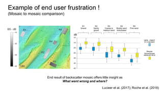
![Why?
● Validation of backscatter processing steps
○ Using same data set, may result in different final products
○ Need input from developers to document the processing chain better
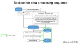
● Backscatter working group (BSWG, 2015) recommended:
“to check the consistency of the processing results provided by various software suites,
initiatives promoting comparative tests on common data sets should be encouraged [...]” (Lurton
and Lamarche, 2015: BSWG report ).
Proprietary
ProcessingRaw data Mosaic
Angular
response](https://image.slidesharecdn.com/maliketalshallowsurvey2018backscatterintercomparison-181007031038/85/Backscatter-Working-Group-Software-Inter-comparison-Project-Requesting-and-Comparing-Intermediate-Backscatter-Processing-Results-2-320.jpg)
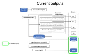
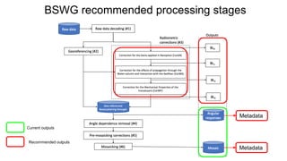
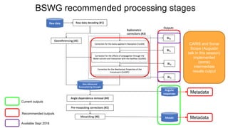
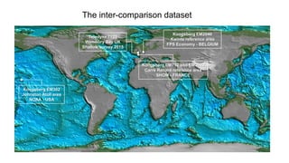
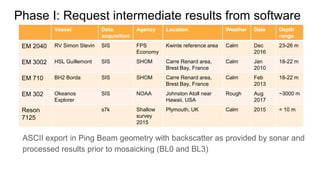

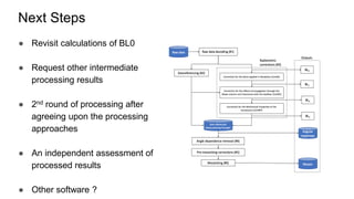

The document outlines a collaborative project aimed at inter-comparing intermediate backscatter processing results from various software developers and users, initiated by the Backscatter Working Group. It emphasizes the need for standardized processing chains, documentation of results, and addressing discrepancies in backscatter outputs from different tools. The project includes multiple stages, from requesting intermediate results to developing best practices for backscatter data processing.


![Beach slopes from satellite-derived shorelines [Coast2Coast presentation]](https://cdn.slidesharecdn.com/ss_thumbnails/coast2coastkvosslideshare-200513061851-thumbnail.jpg?width=640&height=640&fit=bounds)