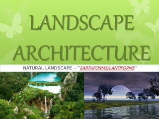
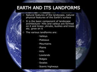
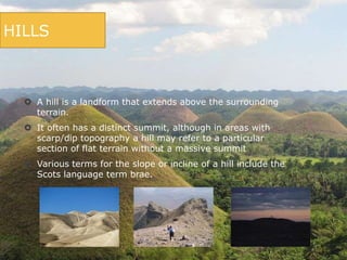
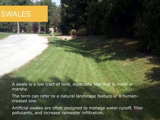
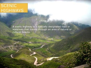
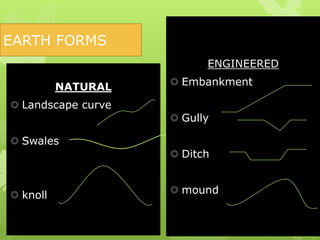
LANDSCAPE 
ARCHITECTURE 
NATURAL LANDSCAPE – “EARTHFORMS/LANDFORMS”
 Natural features of the landscape, natural 
physical features of the Earth's surface 
 It is the basic component of landscape 
architecture- Hills and valleys are formed 
on it and Grass ,shrubs, bushes and trees 
etc. grow on it 
 The various landforms are: 
Valleys 
Plateaus 
Mountains 
Plains 
Hills 
Lowlands 
Ridges 
Swales 
Scenic highways
NATURAL LANDSCAPE CHARACTER 
The landscape character of any area may 
be developed or intensified by 
eliminating any negative elements and 
by accentuating its positive qualities. 
MAJOR MINOR 
 Mountain ranges 
 River valleys and coastal 
plains 
 And forces as winds, tides, 
sea solar radiations 
,gravity etc. 
 Preservation of the natural 
form 
 Destruction of the natural 
form 
 Alteration of the natural 
form 
 Accentuation of the 
natural form
CONTOURS 
 The shape or the relief of the ground surface can be indicated by 
contours. 
 These are the lines of equal height above a fixed reference point 
or bench mark of known or assumed elevation. These lines 
basically join points which have equal heights above the fixed 
point. they are considered to be the signatures of the land 
form along with the Hachure. 
 Hachure are also representative lines which are drawn 
perpendicular to the slope.
RIDGES 
 A ridge is a geological feature consisting of a chain 
of mountains or hills that form a continuous 
elevated crest for some distance. 
 Ridges are usually termed hills or mountains as 
well, depending on size. 
 There are several main types of ridges:- 
 Shutter ridges:- A shutter ridge is a ridge which 
has moved along a fault line, blocking or diverting 
drainage 
 Dune ridges:- In areas of large-scale dune activity, 
certain types of dunes result in sand ridges. 
 Crater ridges:- Large meteorite strikes typically 
form large impact craters bordered by circular 
ridges.
VALLEYS 
 A valley is a low area between hills, often with a river running 
through it. 
 The terms U-shaped and V-shaped are descriptive terms of 
geography to characterize the form of valleys. 
 A valley formed by flowing water, or river valley, is usually V-shaped. 
 Shallower slopes may produce broader and gentler valleys.
PLATEAUS 
 A plateau also called a high plain or tableland, is an 
area of highland, usually consisting of relatively flat 
terrain. 
 Plateaus can be formed by a number of processes, 
including upwelling of volcanic magma, extrusion of 
lava, and erosion by water and glaciers. 
 Plateaus are classified according to their surrounding 
environment.
PLATEAUS 
 Intermontane plateaus are the highest in the 
world, bordered by mountains. The Tibetan Plateau is 
one such plateau. 
 Piedmont plateaus are bordered on one side by 
mountains and on the other by a plain or sea. 
 Continental plateaus are bordered on all sides by 
the plains or seas, forming away from mountains. 
 Volcanic plateaus are produced by volcanic activity. 
The Columbia Plateau in the northwestern United 
States of America is one such plateau. 
 Dissected plateaus are highly eroded plateaus cut 
by rivers and broken by deep narrow valleys.
MOUNTAINS 
 A mountain is a large landform that stretches above the 
surrounding land in a limited area, usually in the form of 
a peak. 
 A mountain is generally steeper than a hill. 
 Mountains are formed through tectonic forces or 
volcanism. These forces can locally raise the surface of 
the earth. 
 A few mountains are isolated summits, but most occur in 
huge mountain ranges.
MOUNTAINS 
 The UN Environmental Programme's definition of 
"mountainous environment" includes any of the 
following: 
 Elevation of at least 2,500 m (8,200 ft); 
 Elevation of at least 1,500 m (4,900 ft), with a slope 
greater than 2 degrees; 
 Elevation of at least 1,000 m (3,300 ft), with a slope 
greater than 5 degrees; 
 Elevation of at least 300 m (980 ft), with a 300 m (980 
ft) elevation range within 7 km (4.3 mi).
MOUNTAINS 
 There are three main types of mountains: volcanic, fold, and 
block. 
 Heights of mountains are typically measured above sea level. 
 There are at least 100 mountains with heights of over 7,200 
metres (23,622 ft) above sea level, all of which are located in 
central and southern Asia. 
 Mountaineering, mountain climbing, or alpinism is the sport, 
hobby or profession of hiking, skiing, and climbing mountains.
MOUNTAINS- VOLCANOES 
 A volcano is a rupture on the crust of a planetary mass object, 
such as the Earth, which allows hot lava, volcanic ash, and 
gases to escape from a magma chamber below the surface.
MOUNTAINS- FOLDS 
 Fold mountains are mountains that form mainly by the 
effects of folding on layers within the upper part of the 
Earth's crust. 
 The forces responsible for formation of the fold mountains 
are called orogenic movements. 
 The term orogenic has derived from a Greek word meaning 
mountain building. 
 These forces act at tangent to the surface of the earth and 
are primarily a result of plate tectonics.
MOUNTAINS- FAULTS 
 Fault blocks are very large blocks of rock, sometimes 
hundreds of kilometers in extent, created by tectonic and 
localized stresses in the Earth's crust. 
 Large areas of bedrock are broken up into blocks by faults. 
 Landforms (mountains, hills, ridges, lakes, valleys, etc.) are 
sometimes formed when 
the faults have a large 
vertical displacement.
LOWLANDS 
 In studies of the ecology of freshwater rivers, habitats 
are classified as upland and lowland. 
 They are generally more turbid, warm, slow-flowing 
waters and fine sediment beds of lowland rivers 
encourage fish species with broad temperature 
tolerances and greater tolerances to low oxygen levels, 
and life history and breeding strategies adapted to these 
and other traits of lowland rivers. 
 These characteristics also encourage invertebrate 
species with broad temperature tolerances and greater 
tolerances to low oxygen levels and ecologies revolving 
around fine sediments or alternative habitats such as 
submerged woody snags or water weed.
PLAINS 
 In geography, a plain is a flat region. 
 Plains occur as lowlands and at the bottoms of valleys but also on 
plateaus or uplands at high elevations. 
 Where a geological region contains more than one plain, they may be 
connected by a pass (sometime termed a gap). 
 Plains may have been formed from flowing lava, deposited by water, 
ice cold wind, or formed by erosion by these agents from hills and 
mountains.
HILLS 
 A hill is a landform that extends above the surrounding 
terrain. 
 It often has a distinct summit, although in areas with 
scarp/dip topography a hill may refer to a particular 
section of flat terrain without a massive summit 
 Various terms for the slope or incline of a hill include the 
Scots language term brae.
SWALES 
 A swale is a low tract of land, especially one that is moist or 
marshy. 
 The term can refer to a natural landscape feature or a human-created 
one. 
 Artificial swales are often designed to manage water runoff, filter 
pollutants, and increase rainwater infiltration.
SCENIC 
HIGHWAYS 
 A scenic highway is a specially designated road or 
waterway that travels through an area of natural or 
cultural beauty.
ENGINEERED 
 Embankment 
 Gully 
 Ditch 
 mound 
EARTH FORMS 
NATURAL 
 Landscape curve 
 Swales 
 knoll
WHY ARE THEY NEEDED? 
 To diminish landscape disruption 
 To reduce cost of earth work 
 To prevent the wasting of top soil 
 To preclude the need for erosion control 
and replanting 
 To make use of existing drainage ways 
 To blend into the natural scene 
 To adapt to them is to harmonize with the 
forces and conditions by which they have 
evolved.
THANK YOU! 
Presented by: 
11603 – Nisha Kumari 
11609 – Aneesha Dhiman 
11613 – Sahil Kaundal 
11620 – Yashasvi Sharma 
11634 – Jyoti Negi 
B.Arch. 4th year 7th semester 
National Institute of Technology 
(Hamirpur, H.P.)

Earthforms

  • 1.
    LANDSCAPE ARCHITECTURE NATURALLANDSCAPE – “EARTHFORMS/LANDFORMS”
  • 2.
     Natural featuresof the landscape, natural physical features of the Earth's surface  It is the basic component of landscape architecture- Hills and valleys are formed on it and Grass ,shrubs, bushes and trees etc. grow on it  The various landforms are: Valleys Plateaus Mountains Plains Hills Lowlands Ridges Swales Scenic highways
  • 3.
    NATURAL LANDSCAPE CHARACTER The landscape character of any area may be developed or intensified by eliminating any negative elements and by accentuating its positive qualities. MAJOR MINOR  Mountain ranges  River valleys and coastal plains  And forces as winds, tides, sea solar radiations ,gravity etc.  Preservation of the natural form  Destruction of the natural form  Alteration of the natural form  Accentuation of the natural form
  • 4.
    CONTOURS  Theshape or the relief of the ground surface can be indicated by contours.  These are the lines of equal height above a fixed reference point or bench mark of known or assumed elevation. These lines basically join points which have equal heights above the fixed point. they are considered to be the signatures of the land form along with the Hachure.  Hachure are also representative lines which are drawn perpendicular to the slope.
  • 5.
    RIDGES  Aridge is a geological feature consisting of a chain of mountains or hills that form a continuous elevated crest for some distance.  Ridges are usually termed hills or mountains as well, depending on size.  There are several main types of ridges:-  Shutter ridges:- A shutter ridge is a ridge which has moved along a fault line, blocking or diverting drainage  Dune ridges:- In areas of large-scale dune activity, certain types of dunes result in sand ridges.  Crater ridges:- Large meteorite strikes typically form large impact craters bordered by circular ridges.
  • 6.
    VALLEYS  Avalley is a low area between hills, often with a river running through it.  The terms U-shaped and V-shaped are descriptive terms of geography to characterize the form of valleys.  A valley formed by flowing water, or river valley, is usually V-shaped.  Shallower slopes may produce broader and gentler valleys.
  • 7.
    PLATEAUS  Aplateau also called a high plain or tableland, is an area of highland, usually consisting of relatively flat terrain.  Plateaus can be formed by a number of processes, including upwelling of volcanic magma, extrusion of lava, and erosion by water and glaciers.  Plateaus are classified according to their surrounding environment.
  • 8.
    PLATEAUS  Intermontaneplateaus are the highest in the world, bordered by mountains. The Tibetan Plateau is one such plateau.  Piedmont plateaus are bordered on one side by mountains and on the other by a plain or sea.  Continental plateaus are bordered on all sides by the plains or seas, forming away from mountains.  Volcanic plateaus are produced by volcanic activity. The Columbia Plateau in the northwestern United States of America is one such plateau.  Dissected plateaus are highly eroded plateaus cut by rivers and broken by deep narrow valleys.
  • 9.
    MOUNTAINS  Amountain is a large landform that stretches above the surrounding land in a limited area, usually in the form of a peak.  A mountain is generally steeper than a hill.  Mountains are formed through tectonic forces or volcanism. These forces can locally raise the surface of the earth.  A few mountains are isolated summits, but most occur in huge mountain ranges.
  • 10.
    MOUNTAINS  TheUN Environmental Programme's definition of "mountainous environment" includes any of the following:  Elevation of at least 2,500 m (8,200 ft);  Elevation of at least 1,500 m (4,900 ft), with a slope greater than 2 degrees;  Elevation of at least 1,000 m (3,300 ft), with a slope greater than 5 degrees;  Elevation of at least 300 m (980 ft), with a 300 m (980 ft) elevation range within 7 km (4.3 mi).
  • 11.
    MOUNTAINS  Thereare three main types of mountains: volcanic, fold, and block.  Heights of mountains are typically measured above sea level.  There are at least 100 mountains with heights of over 7,200 metres (23,622 ft) above sea level, all of which are located in central and southern Asia.  Mountaineering, mountain climbing, or alpinism is the sport, hobby or profession of hiking, skiing, and climbing mountains.
  • 12.
    MOUNTAINS- VOLCANOES A volcano is a rupture on the crust of a planetary mass object, such as the Earth, which allows hot lava, volcanic ash, and gases to escape from a magma chamber below the surface.
  • 13.
    MOUNTAINS- FOLDS Fold mountains are mountains that form mainly by the effects of folding on layers within the upper part of the Earth's crust.  The forces responsible for formation of the fold mountains are called orogenic movements.  The term orogenic has derived from a Greek word meaning mountain building.  These forces act at tangent to the surface of the earth and are primarily a result of plate tectonics.
  • 14.
    MOUNTAINS- FAULTS Fault blocks are very large blocks of rock, sometimes hundreds of kilometers in extent, created by tectonic and localized stresses in the Earth's crust.  Large areas of bedrock are broken up into blocks by faults.  Landforms (mountains, hills, ridges, lakes, valleys, etc.) are sometimes formed when the faults have a large vertical displacement.
  • 15.
    LOWLANDS  Instudies of the ecology of freshwater rivers, habitats are classified as upland and lowland.  They are generally more turbid, warm, slow-flowing waters and fine sediment beds of lowland rivers encourage fish species with broad temperature tolerances and greater tolerances to low oxygen levels, and life history and breeding strategies adapted to these and other traits of lowland rivers.  These characteristics also encourage invertebrate species with broad temperature tolerances and greater tolerances to low oxygen levels and ecologies revolving around fine sediments or alternative habitats such as submerged woody snags or water weed.
  • 16.
    PLAINS  Ingeography, a plain is a flat region.  Plains occur as lowlands and at the bottoms of valleys but also on plateaus or uplands at high elevations.  Where a geological region contains more than one plain, they may be connected by a pass (sometime termed a gap).  Plains may have been formed from flowing lava, deposited by water, ice cold wind, or formed by erosion by these agents from hills and mountains.
  • 17.
    HILLS  Ahill is a landform that extends above the surrounding terrain.  It often has a distinct summit, although in areas with scarp/dip topography a hill may refer to a particular section of flat terrain without a massive summit  Various terms for the slope or incline of a hill include the Scots language term brae.
  • 18.
    SWALES  Aswale is a low tract of land, especially one that is moist or marshy.  The term can refer to a natural landscape feature or a human-created one.  Artificial swales are often designed to manage water runoff, filter pollutants, and increase rainwater infiltration.
  • 19.
    SCENIC HIGHWAYS A scenic highway is a specially designated road or waterway that travels through an area of natural or cultural beauty.
  • 20.
    ENGINEERED  Embankment  Gully  Ditch  mound EARTH FORMS NATURAL  Landscape curve  Swales  knoll
  • 21.
    WHY ARE THEYNEEDED?  To diminish landscape disruption  To reduce cost of earth work  To prevent the wasting of top soil  To preclude the need for erosion control and replanting  To make use of existing drainage ways  To blend into the natural scene  To adapt to them is to harmonize with the forces and conditions by which they have evolved.
  • 22.
    THANK YOU! Presentedby: 11603 – Nisha Kumari 11609 – Aneesha Dhiman 11613 – Sahil Kaundal 11620 – Yashasvi Sharma 11634 – Jyoti Negi B.Arch. 4th year 7th semester National Institute of Technology (Hamirpur, H.P.)