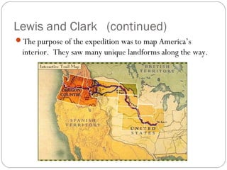
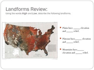
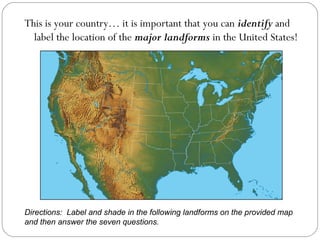
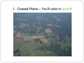
Chapter 2

Mapping Earth’s Surface
Earth’s Four Spheres
                  Atmosphere: gaseous part of
                   Earth
                  Hydrosphere: liquid part of
                   the Earth
                  Biosphere: living part of
                   Earth
                  Lithosphere: solid part of
                   Earth
                   We will spend the next few
                        months on Geology!
The Shape of the Land
                   Topography: the shape of the
                    land
                   The ground looks like it does
                    because of internal and external
                    forces constantly changing its
                    shape.
                   Think about the “shape” of
                    Shaler…. Why does it look this
                    way?
                   Topography is determined by
                    three different things…
Topography Characteristics
                     Elevation: height above sea
                      level
                     Relief: difference between
                      high and low points
                     Landforms: features of
                      topography that shape the
                      land


   Topographic Map
3 Types of Landforms
                   Plains
                    Low elevation
                    Low relief
                    Two types of
                       Plains
                       Coastal
                       Interior
3 Types of Landforms (continued)
                  Mountains
                   High elevation
                   High relief
                   Mountains are
                     arranged into:
                     Ranges
                     Systems
                     Belts
3 Types of Landforms (continued)
                     Plateaus
                      High elevation
                      Low relief
                      Canyons form
                       on plateaus
Lewis and Clark
                  In 1804, an expedition set
                   out from St. Louis to
                   explore the land between
                   the Mississippi River and
                   the Pacific Ocean.
                  The United States had just
                   purchased a part of this vast
                   territory, called Louisiana,
                   from France.
                    (The Louisiana Purchase)
Lewis and Clark (continued)
The purpose of the expedition was to map America’s
 interior. They saw many unique landforms along the way.
Landforms in the United States
Landforms Review:
Using the words High and Low, describe the following landforms.


                                                     Plains have _____ elevation
                                                      and _____ relief.

                                                     Plateaus have_____ elevation
                                                      and _____ relief.

                                                     Mountains have_____
                                                      elevation and _____ relief.
This is your country… it is important that you can identify and
  label the location of the major landforms in the United States!


Directions: Label and shade in the following landforms on the provided map
and then answer the seven questions.
1. Coastal Plains – You’ll color in green!
2. Interior Plains – You’ll color in Yellow!
3. Plateaus and Highlands – You’ll color in Red!
4. Great Basin– You’ll color in
          Orange!
Folded Mountains
    ~formed by pressure from both sides~


5. Appalachian Mountains – Shade all mountain areas brown!
Up-Warped Mountains
 ~formed by pressure pushing up from below~


6. Rocky Mountains, 7. Black Hills, 8. Adirondack Mountains
Fault Block Mountains
         ~formed along a break in the crust~


9. Big Horn Mountains, 10. Sierra Nevada, 11. Cascade Mountains
Volcanic Mountains
~formed by volcanic eruptions~


     12. Mount St. Helens

2.1 mapping earth's surface

  • 1.
  • 2.
    Earth’s Four Spheres Atmosphere: gaseous part of Earth Hydrosphere: liquid part of the Earth Biosphere: living part of Earth Lithosphere: solid part of Earth We will spend the next few months on Geology!
  • 3.
    The Shape ofthe Land  Topography: the shape of the land  The ground looks like it does because of internal and external forces constantly changing its shape.  Think about the “shape” of Shaler…. Why does it look this way?  Topography is determined by three different things…
  • 4.
    Topography Characteristics Elevation: height above sea level Relief: difference between high and low points Landforms: features of topography that shape the land Topographic Map
  • 5.
    3 Types ofLandforms Plains Low elevation Low relief Two types of Plains Coastal Interior
  • 6.
    3 Types ofLandforms (continued) Mountains High elevation High relief Mountains are arranged into: Ranges Systems Belts
  • 7.
    3 Types ofLandforms (continued) Plateaus High elevation Low relief Canyons form on plateaus
  • 8.
    Lewis and Clark In 1804, an expedition set out from St. Louis to explore the land between the Mississippi River and the Pacific Ocean. The United States had just purchased a part of this vast territory, called Louisiana, from France. (The Louisiana Purchase)
  • 9.
    Lewis and Clark(continued) The purpose of the expedition was to map America’s interior. They saw many unique landforms along the way.
  • 10.
    Landforms in theUnited States
  • 11.
    Landforms Review: Using thewords High and Low, describe the following landforms.  Plains have _____ elevation and _____ relief.  Plateaus have_____ elevation and _____ relief.  Mountains have_____ elevation and _____ relief.
  • 12.
    This is yourcountry… it is important that you can identify and label the location of the major landforms in the United States! Directions: Label and shade in the following landforms on the provided map and then answer the seven questions.
  • 13.
    1. Coastal Plains– You’ll color in green!
  • 14.
    2. Interior Plains– You’ll color in Yellow!
  • 15.
    3. Plateaus andHighlands – You’ll color in Red!
  • 16.
    4. Great Basin–You’ll color in Orange!
  • 17.
    Folded Mountains ~formed by pressure from both sides~ 5. Appalachian Mountains – Shade all mountain areas brown!
  • 18.
    Up-Warped Mountains ~formedby pressure pushing up from below~ 6. Rocky Mountains, 7. Black Hills, 8. Adirondack Mountains
  • 19.
    Fault Block Mountains ~formed along a break in the crust~ 9. Big Horn Mountains, 10. Sierra Nevada, 11. Cascade Mountains
  • 20.
    Volcanic Mountains ~formed byvolcanic eruptions~ 12. Mount St. Helens