Downloaded 10 times

![DISCLAIMER
These opinions are my own, they are not the opinions
of MIT, Brookings, any of the project funders, nor (with
the exception of co-authored previously published
work) my collaborators
Secondary disclaimer:
“It’s tough to make predictions, especially about the
future!”
-- Attributed to Woody Allen, Yogi Berra, Niels Bohr, Vint Cerf, Winston
Churchill, Confucius, Disreali [sic], Freeman Dyson, Cecil B. Demille, Albert
Einstein, Enrico Fermi, Edgar R. Fiedler, Bob Fourer, Sam Goldwyn, Allan
Lamport, Groucho Marx, Dan Quayle, George Bernard Shaw, Casey Stengel, Will
Rogers, M. Taub, Mark Twain, Kerr L. White, etc.
Crowd-Sourced Mapping for Open Government](https://image.slidesharecdn.com/decbrownbagcrowdsourcedmapping-131213081211-phpapp02/85/Crowd-Sourced-Mapping-for-Open-Government-3-320.jpg)


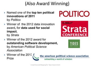
![Maybe Use a Computer?
only
had
manpower and
―In ―Until recentlyof thispolitical partiesequalthepopulation. Nowthe tools to redrawthis
summary, keeping districtstechnology and educationpolitically play
eliminationdescribe a — feedandanybody can last
ofingerrymandering the
―The rapid advancesway to do reapportionment simple into the computer
―There is only one in computer to
during would
boundaries while Article is …
―The purpose
two decadesrequire thewhich canasdraw contiguousan analysis firm Caliper
all the to least as aitkibitzer. Forsimple toreapportion aof districts of equal
game, computer relatively as little $3,500 the legislature or other
feasibleat make program registration.‖
seem factors except politicalestablishmentgeographicautomatic
population Reagan havesame time to and census data you need to redistricting
- Ronald [and] at the the software further whatever secondary goalsnovel
Corp. will let you [Goff 1973]
body of people who represent geo- graphical districts. …The try out the
and impersonaldesigned to implement carrying outothers have put
“Let a computer do it”
State has.”proposed is procedure for the value judgments of
geometries on a PC screen. Harvard researcher Micah Altman and a
program
- -Washington Post,in that
Justice Brennan, appears to districts. at all difficult
together a program Karcher v. Daggett [Nagel
those responsible for reapportionment‖–(1983) 1965]
redistricting. It2003 draws compactbe notHis software is free. to
( And many, many blogs)
devise rules for doing this which a census, a commission in each
Democratic redistricting could work like this. After will produce
state entertains proposals from the political parties and any do-gooder group or
results not markedly inferior to those which would
individual willing to compete. The commission picks the most compact
be solution, according to some simple criterion. (Say, add up the miles of boundary
arrived at by a genuinely disinterested
lines, giving any segments that track 1961]
a 50% discount, and go for
commission.‖ -- [Vickrey municipal bordersinspire some gifted amateurs
the shortest total.) The mathematical challenge might
to weigh in.” – William Baldwin, Forbes 2008](https://image.slidesharecdn.com/decbrownbagcrowdsourcedmapping-131213081211-phpapp02/85/Crowd-Sourced-Mapping-for-Open-Government-9-320.jpg)
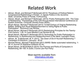
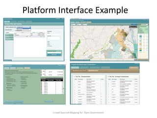
![Two Challenges
It’s hard.
(Optimal delimitation
with simple criteria is
NP-hard [Altman 1997])
Neutral criteria, aren’t.
(Parker 1990)
1 r é
r! ù
r
n
S( n,r) = å ê( -1) ( r - i)
ú=
r! i=0 ë
( r - i)!i!û
Crowd-Sourced Mapping for Open Government](https://image.slidesharecdn.com/decbrownbagcrowdsourcedmapping-131213081211-phpapp02/85/Crowd-Sourced-Mapping-for-Open-Government-10-320.jpg)


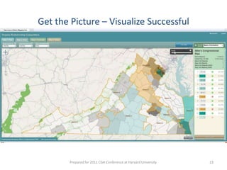


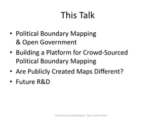
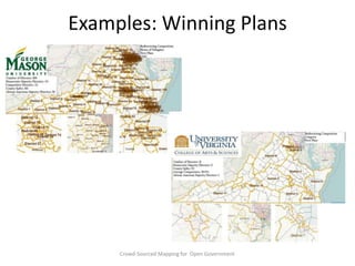
![Plan Evaluation Criteria
Majority-Minority
Representation
Number of districts in which minority population > 50% of the
district
Population Equality percentage deviation from ideal district population
County Integrity
Number of times counties & independent cities are split by
districts
Compactness
Normalized ratio of (perimeter of district)/(area of district)^2
Partisan Balance
Number of Republican leaning districts minus
Number of Democratic-leaning districts
Competitiveness
Number of districts with normal Democratic vote share in [45%55%]
Crowd-Sourced Mapping for Open Government](https://image.slidesharecdn.com/decbrownbagcrowdsourcedmapping-131213081211-phpapp02/85/Crowd-Sourced-Mapping-for-Open-Government-37-320.jpg)


The document discusses crowd-sourced mapping for open government, emphasizing the importance of transparency and public participation in electoral boundary delimitation. It outlines the development and features of a platform that enables the public to create and evaluate redistricting plans while providing guidelines for transparency in the redistricting process. The document also highlights the successful application of these concepts in various states and the impact of student involvement in generating legal districting plans.


