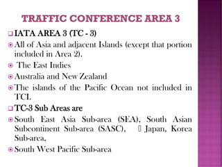
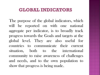
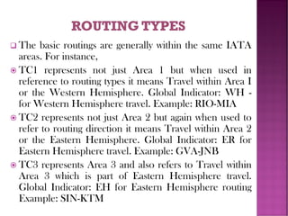
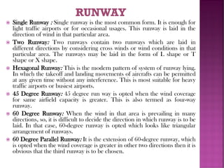
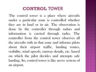
Presented By:
Md. Shaifullar Rabbi
BBA & MBA (Major inTHM,FBS,DU)
Lecturer
Dept. ofTourism & Hospitality Management
Daffodil Institute of IT(NU)
Transportation systems are a fundamental
part of logistics and planning whenever
vehicles are used to move people or items
from one location to another. They allow
people to get to work on time using the local
bus or train service, and they allow airlines to
tell their customers when they can expect an
airplane to arrive at its destination.
At its most basic, the term “transportation
system” is used to refer to the equipment
and logistics of transporting passengers
and goods. It covers movement by all
forms of transport, from cars and buses to
boats, aircraft and even space travel.
Transportation systems are employed in
troop movement logistics and planning, as
well as in running the local school bus
service.
The purpose of a transportation system is to
coordinate the movement of people, goods
and vehicles in order to utilize routes most
efficiently. When implemented,
transportation systems seek to reduce
transport costs and improve delivery times
through effective timetabling and route
management. Periodic re-evaluations and the
development of alternative routes allow for
timely changes to the transportation system in
order to maintain efficiency.
Animal-powered
Air
Human-powered
Land
Rail
Road
Water
 Micro mobility is the collective name for small electric
powered vehicles.
 The Trans-Alaska Pipeline System conveys crude oil from
the Prudhoe Bay Oil Field to Valdez, Alaska
 Pipeline transport sends goods through a pipe, most
commonly liquid and gases are sent, but pneumatic
tubes can also send solid capsules using compressed air.
 Cable transport is a broad mode where vehicles are pulled
by cables instead of an internal power source.
 Space transport is transport out of Earth's atmosphere into
outer space by means of a spacecraft.
 Medical vehicle transport (drone transport) is being used for
medicine transportation.
Transportation infrastructure:
Thoroughfares, networks, hubs (stations, bus
terminals, airport terminals), etc.
Vehicles and containers: motor vehicles, auto
mobiles, motorcycles, trucks, wagons, trains,
ships, and aircraft
A stationary or mobile workforce
Propulsion system and power supply (traction)
Operations: driving, management, traffic
signals, railway signaling, air traffic control, etc.
Infrastructure
Vehicles
Operation
Policy
Functions
Passenger
Medical
Freight
❑ For the purpose of standardization, IATA has
divided the world into three areas called
IATA Traffic Conference Areas for the
purpose of regulations.
 IATA’s these three Areas are known as
 TC1 (IATA Traffic Conference Area 1)
 TC2 IATA Traffic Conference Area 2)
 TC3 (IATA Traffic Conference Area 3)
❑ IATA AREA I (TC - I)
 All of the North and South American continents and
adjacent islands.
 Central America
 Greenland
 Bermuda
 The West Indies and the Caribbean Islands
 The Hawaiian Islands (including Midway and
Palmyra)
❑ TC 1 Sub Areas are
 North America, Central, Caribbean, South America
 North Atlantic sub-area, Mid Atlantic sub-area, South
Atlantic sub-area
❑ IATA AREA 2 (TC - 2)
 All of Europe including part of the Commonwealth of
Independent States (CIS) and adjacent Islands.
 Iceland
 The Azores
 All of Africa and the adjacent Islands
 Ascension Island
 That part of Asia lying west of and including Iran.
❑ TC-2 Sub Areas are
 Europe,
 Middle East
 All Africa
❑ IATA AREA 3 (TC - 3)
 All of Asia and adjacent Islands (except that portion
included in Area 2).
 The East Indies
 Australia and New Zealand
 The islands of the Pacific Ocean not included in
TCI.
❑ TC-3 Sub Areas are
 South East Asia Sub-area (SEA), South Asian
Subcontinent Sub-area (SASC), Japan, Korea
Sub-area,
 South West Pacific Sub-area
The purpose of the global indicators, which
will be reported on with one national
aggregate per indicator, is to broadly track
progress towards the Goals and targets at the
global level. They are also useful for
countries to communicate their current
situation, both to the international
community to raise awareness of challenges
and needs, and to the own population to
show that progress is being made.
 WH - Western Hemisphere: Any journey from one place to
another in IATA area 1 is called Western Hemisphere.
 EH - Eastern Hemisphere: Any journey within IATA area 2
or area 3 or between area 2 and 3 is called Eastern
Hemisphere.
 PA - Pacific Route: Any journey between IATA area 1 and
area 3 via Pacific ocean is called Pacific route.
 AT - Atlantic Route: Any journey between IATA area 1 and
area 2 via Atlantic ocean is called Atlantic route.
 AP - Atlantic and Pacific Route: Any journey between IATA
area 2 and area 3 via Atlantic and Pacific ocean is called
Atlantic and Pacific route.
 TS - Trans Siberian Route: Any journey from Europe to Far
East via Moscow is called Trans Siberian route.
 PO - Polar Route: Any journey from Europe to Far East via
Alaska is called Polar route.
❑ The objectives of the air transport policy and regulation
program are to:
 reduce State’s costs in performing its economic
regulatory functions
 increase consumer's benefits and choices;
 improve air connectivity; and
 create more competitive business opportunities in the
marketplace;
Thereby contributing to the sustainable economic
development and to the expansion of trade and tourism.
 Harmonizing global regulatory framework by developing policies and guidance as
those contained in the (Doc 8632); Policy Guidance on the Economic Regulation
of International Air Transport (Doc 9587), Manual on the Regulation of
International Air Transport (Doc 9626), and ICAO's Policies on Taxation in the
Field of International Air Transport
 Serving as a global forum for cooperation and concerted actions , such as
the sixth Worldwide Air Transport Conference on the Sustainability of Air
Transport (ATConf/6, March 2013);
 Providing practical solutions to address challenges of emerging regulatory
challenges of global importance , such as market access, air carrier ownership and
control, consumer protection, competition, assurance of essential services,
and trade in services;
 Enhancing transparency of air transport through dissemination and exchange of
information on States’ policies and practices, air service agreements, taxes,
and industry trends and developments ; and
 Facilitating States' air services negotiations and business-to-business
networking among States, international organizations, aviation industry, tourism
and other stakeholders (see ICAO Air Services Negotiation (ICAN) event).
❑ The basic routings are generally within the same IATA
areas. For instance,
 TC1 represents not just Area 1 but when used in
reference to routing types it means Travel within Area I
or the Western Hemisphere. Global Indicator: WH -
for Western Hemisphere travel. Example: RIO-MIA
 TC2 represents not just Area 2 but again when used to
refer to routing direction it means Travel within Area 2
or the Eastern Hemisphere. Global Indicator: ER for
Eastern Hemisphere travel. Example: GVA-JNB
 TC3 represents Area 3 and also refers to Travel within
Area 3 which is part of Eastern Hemisphere travel.
Global Indicator: EH for Eastern Hemisphere routing
Example: SIN-KTM
 The long haul routings are between two areas. Such routings
may involve traveling via another area or ocean crossings,
TC12 Travel between Area 1 and Area 2 Global Indicator:
AT via the Atlantic Example: LON-NYC-RIO TC3]
 Travel between Area 3 and Area 1 via the Pacific Global
Indicator: PA via the North l Central Pacific Example: SIN-
YVR PN Pacific via North America Example: SYD - LAX -
RIO SP via the South Polar route between the South Atlantic
areas, Bolivia, Peru and the South West Pacific over
Auckland and Buenos Aires
 TC 123 Travel between Area 1 and Area 3 (via Area 2)
Global Indicator: AT a Transatlantic routing Example: DAC-
LON-NYC
 SA a type of transatlantic routing between South Atlantic
Area and Southeast Asia over Johannesburg Example: RlO-
JNB-HKG, RlO-BKK on RG
 As we all know there are different times in different country, here
we could learn the international time difference and the standard
time. As all arrival and departure times are always shown in Local
Times, so it is not possible to subtract one from the other, and give
the answer of the flying time, when a passenger wanted to know.
 Because of the rotation of the earth, the pattern of night and day
varies throughout the world. And this is the reason that times
changes as we travel East to West or West to East around the
world.
 We all know our day and night together 24 hours as a result the
earth’s surface is theoretically divided into 24 time zones. The
difference is measured east or west of the 20 Meridian (or line of
longitude), which passes Greenwich. England.
 The time at Greenwich, this is referred to as Greenwich Mean
Time or GMT. is the internationally agreed standard time. West of
Greenwich is minus GMT. East of’ Greenwich is Plus GMT. So
Standard Clock Time is shown in hours and minutes fast (+) or
slow (-) of GMT.
Station that consists of buildings and
airfields used to house and provide runways
for airplanes. Navigation towers are also
present at airports to provide pilots with
direction when landing and taking off of
runways. Most airports also have terminals
for passengers to load onto and unload from
airplanes. Airports are usually built on the
ground, but there are also usable airports
present on boats as well as bodies of water.
Runway
Taxiway
Apron
Terminal building
Control tower
Hanger
Parking
 Single Runway : Single runway is the most common form. It is enough for
light traffic airports or for occasional usages. This runway is laid in the
direction of wind in that particular area.
 Two Runway: Two runways contain two runways which are laid in
different directions by considering cross winds or wind conditions in that
particular area. The runways may be laid in the form of L shape or T
shape or X shape.
 Hexagonal Runway: This is the modern pattern of system of runway lying.
In which the takeoff and landing movements of aircrafts can be permitted
at any given time without any interference. This is most suitable for heavy
traffic airports or busiest airports.
 45 Degree Runway: 45 degree run way is opted when the wind coverage
for same airfield capacity is greater. This is also termed as four-way
runway.
 60 Degree Runway: When the wind in that area is prevailing in many
directions, so, it is difficult to decide the direction in which runway is to be
laid. In that case, 60-degree runway is opted which looks like triangular
arrangement of runways.
 60 Degree Parallel Runway: It is the extension of 60-degree runway, which
is opted when the wind coverage is greater in other two directions then it is
obvious that the third runway is to be chosen.
Taxiway is path which connects each end of
the runway with terminal area, apron,
hanger etc. These are laid with asphalt or
concrete like runways. In modern airports,
taxiways are laid at an angle of 30 degree to
the runway so that aircrafts can use it to
change from one runway to other easily.
The turning radius at taxiway and runway
meets should be more than 1.5 times of
width of taxiway.
Apron is a place which is used as parking
place for aircrafts. It is also used for loading
and unloading of aircrafts. Apron is
generally paved and is located in front of
terminal building or adjacent to hangers.
The size of area to be allotted for apron
and design of apron is generally governed
by the number of aircrafts expected in the
airport. The aircraft characteristics also
considered while design.
Terminal building is a place where
airport administration facilities take
place. In this building, pre-journey and
post journey checking’s of passengers
takes place. Lounges, cafes etc. are
provided for the passengers. Passengers
can directly enter the plane from
terminal buildings through sky bridge,
walkways etc.
The control tower is a place where aircrafts
under a particular zone is controlled whether
they are in land or in air. The observation is
done by the controller through radars and
information is carried through radio. The
controller from the control tower observes all
the aircrafts with in that zone and informs pilots
about their airport traffic, landing routes,
visibility, wind speeds, runway details, etc. based
on which the pilot decides and attempts safe
landing. So, control tower is like nerve system of
an airport.
Hanger is a place where repairing and
servicing of aircrafts is done. Taxiway
connects the hanger with runway so,
when a repair needed for an aircraft it
can be moved to hanger easily. It is
constructed in the form of large shed
using steel trusses and frames. Large
area should be provided for Hanger for
comfortable movement of aircrafts.
This is a place provided for parking the
vehicles of airport staff or passengers
which is outside the terminal building or
sometimes under the ground of terminal
building.
❑ The following facilities are essential for departing
passengers:
 Check-in facilities, including a baggage drop-off
 Security clearance gates
 Passport control (for some international flights)
 Gates
 Waiting areas
❑ The following facilities are essential for arriving
passengers:
 Passport control (international arrivals only)
 Baggage reclaim facilities, often in the form of a carousel
 Customs (international arrivals only)
 A landside meeting place
❑Cruising may refer to:
Cruising, on a cruise ship
Cruising (driving), driving around for social
purposes, especially by teenagers
Cruising (maritime), leisurely travel by boat,
yacht, or cruise ship
The perfect journey takes you to places
unknown, beyond mere longitudes and
latitudes. Celebrity cruise destinations allow
you to explore all seven continents. Over
300 destinations in 79 countries. From the
charm and history of locations like
Marseille, France, to the rich culture of
Asia, the rugged beauty of Alaska, and the
dreamy beaches of the South Pacific.
 Alaska. Alaska offers breathtaking scenery,
gleaming glaciers and abundant wildlife
 Bahamas. Grab your swimsuit, pack a snorkel,
and get ready for some fun in the sun
 Bermuda. Bermuda, Home of the Pink Sand
Beaches and it's charming British heritage
 Canada / New England
 Caribbean
 Europe
 Hawaii
 Mexico
Located in South Asia, Bangladesh is a
picturesque country with numerous rivers,
mangrove forests, historical sites and an
abundance of wildlife. Cruise tours along
Bangladesh's major rivers is a favored way to
see the country, as it allows visitors to
experience well-known sights and historic
monuments in a relaxing, yet memorable
way.
 Cruise on the Shitalakhya River
 Sonargaon Tour & Cruise on the Shitalakhya
 Cruise on the Shitalakhya
 Cruise on the Shitalakhya to Meghna River
 Cruise on the Turag River
 Cruise on the Turag River to Sadarghat River
front
 Cruise by Paddle Wheel Rocket steamerCruise
on Sundarbans National Park
(Source- Dhaka Holidays)
Transportation (Travel Agency & Tour Operations)

Transportation (Travel Agency & Tour Operations)

  • 2.
    Presented By: Md. ShaifullarRabbi BBA & MBA (Major inTHM,FBS,DU) Lecturer Dept. ofTourism & Hospitality Management Daffodil Institute of IT(NU)
  • 3.
    Transportation systems area fundamental part of logistics and planning whenever vehicles are used to move people or items from one location to another. They allow people to get to work on time using the local bus or train service, and they allow airlines to tell their customers when they can expect an airplane to arrive at its destination.
  • 4.
    At its mostbasic, the term “transportation system” is used to refer to the equipment and logistics of transporting passengers and goods. It covers movement by all forms of transport, from cars and buses to boats, aircraft and even space travel. Transportation systems are employed in troop movement logistics and planning, as well as in running the local school bus service.
  • 5.
    The purpose ofa transportation system is to coordinate the movement of people, goods and vehicles in order to utilize routes most efficiently. When implemented, transportation systems seek to reduce transport costs and improve delivery times through effective timetabling and route management. Periodic re-evaluations and the development of alternative routes allow for timely changes to the transportation system in order to maintain efficiency.
  • 6.
  • 7.
     Micro mobilityis the collective name for small electric powered vehicles.  The Trans-Alaska Pipeline System conveys crude oil from the Prudhoe Bay Oil Field to Valdez, Alaska  Pipeline transport sends goods through a pipe, most commonly liquid and gases are sent, but pneumatic tubes can also send solid capsules using compressed air.  Cable transport is a broad mode where vehicles are pulled by cables instead of an internal power source.  Space transport is transport out of Earth's atmosphere into outer space by means of a spacecraft.  Medical vehicle transport (drone transport) is being used for medicine transportation.
  • 8.
    Transportation infrastructure: Thoroughfares, networks,hubs (stations, bus terminals, airport terminals), etc. Vehicles and containers: motor vehicles, auto mobiles, motorcycles, trucks, wagons, trains, ships, and aircraft A stationary or mobile workforce Propulsion system and power supply (traction) Operations: driving, management, traffic signals, railway signaling, air traffic control, etc.
  • 9.
  • 10.
    ❑ For thepurpose of standardization, IATA has divided the world into three areas called IATA Traffic Conference Areas for the purpose of regulations.  IATA’s these three Areas are known as  TC1 (IATA Traffic Conference Area 1)  TC2 IATA Traffic Conference Area 2)  TC3 (IATA Traffic Conference Area 3)
  • 11.
    ❑ IATA AREAI (TC - I)  All of the North and South American continents and adjacent islands.  Central America  Greenland  Bermuda  The West Indies and the Caribbean Islands  The Hawaiian Islands (including Midway and Palmyra) ❑ TC 1 Sub Areas are  North America, Central, Caribbean, South America  North Atlantic sub-area, Mid Atlantic sub-area, South Atlantic sub-area
  • 12.
    ❑ IATA AREA2 (TC - 2)  All of Europe including part of the Commonwealth of Independent States (CIS) and adjacent Islands.  Iceland  The Azores  All of Africa and the adjacent Islands  Ascension Island  That part of Asia lying west of and including Iran. ❑ TC-2 Sub Areas are  Europe,  Middle East  All Africa
  • 13.
    ❑ IATA AREA3 (TC - 3)  All of Asia and adjacent Islands (except that portion included in Area 2).  The East Indies  Australia and New Zealand  The islands of the Pacific Ocean not included in TCI. ❑ TC-3 Sub Areas are  South East Asia Sub-area (SEA), South Asian Subcontinent Sub-area (SASC), Japan, Korea Sub-area,  South West Pacific Sub-area
  • 14.
    The purpose ofthe global indicators, which will be reported on with one national aggregate per indicator, is to broadly track progress towards the Goals and targets at the global level. They are also useful for countries to communicate their current situation, both to the international community to raise awareness of challenges and needs, and to the own population to show that progress is being made.
  • 15.
     WH -Western Hemisphere: Any journey from one place to another in IATA area 1 is called Western Hemisphere.  EH - Eastern Hemisphere: Any journey within IATA area 2 or area 3 or between area 2 and 3 is called Eastern Hemisphere.  PA - Pacific Route: Any journey between IATA area 1 and area 3 via Pacific ocean is called Pacific route.  AT - Atlantic Route: Any journey between IATA area 1 and area 2 via Atlantic ocean is called Atlantic route.  AP - Atlantic and Pacific Route: Any journey between IATA area 2 and area 3 via Atlantic and Pacific ocean is called Atlantic and Pacific route.  TS - Trans Siberian Route: Any journey from Europe to Far East via Moscow is called Trans Siberian route.  PO - Polar Route: Any journey from Europe to Far East via Alaska is called Polar route.
  • 17.
    ❑ The objectivesof the air transport policy and regulation program are to:  reduce State’s costs in performing its economic regulatory functions  increase consumer's benefits and choices;  improve air connectivity; and  create more competitive business opportunities in the marketplace; Thereby contributing to the sustainable economic development and to the expansion of trade and tourism.
  • 18.
     Harmonizing globalregulatory framework by developing policies and guidance as those contained in the (Doc 8632); Policy Guidance on the Economic Regulation of International Air Transport (Doc 9587), Manual on the Regulation of International Air Transport (Doc 9626), and ICAO's Policies on Taxation in the Field of International Air Transport  Serving as a global forum for cooperation and concerted actions , such as the sixth Worldwide Air Transport Conference on the Sustainability of Air Transport (ATConf/6, March 2013);  Providing practical solutions to address challenges of emerging regulatory challenges of global importance , such as market access, air carrier ownership and control, consumer protection, competition, assurance of essential services, and trade in services;  Enhancing transparency of air transport through dissemination and exchange of information on States’ policies and practices, air service agreements, taxes, and industry trends and developments ; and  Facilitating States' air services negotiations and business-to-business networking among States, international organizations, aviation industry, tourism and other stakeholders (see ICAO Air Services Negotiation (ICAN) event).
  • 19.
    ❑ The basicroutings are generally within the same IATA areas. For instance,  TC1 represents not just Area 1 but when used in reference to routing types it means Travel within Area I or the Western Hemisphere. Global Indicator: WH - for Western Hemisphere travel. Example: RIO-MIA  TC2 represents not just Area 2 but again when used to refer to routing direction it means Travel within Area 2 or the Eastern Hemisphere. Global Indicator: ER for Eastern Hemisphere travel. Example: GVA-JNB  TC3 represents Area 3 and also refers to Travel within Area 3 which is part of Eastern Hemisphere travel. Global Indicator: EH for Eastern Hemisphere routing Example: SIN-KTM
  • 20.
     The longhaul routings are between two areas. Such routings may involve traveling via another area or ocean crossings, TC12 Travel between Area 1 and Area 2 Global Indicator: AT via the Atlantic Example: LON-NYC-RIO TC3]  Travel between Area 3 and Area 1 via the Pacific Global Indicator: PA via the North l Central Pacific Example: SIN- YVR PN Pacific via North America Example: SYD - LAX - RIO SP via the South Polar route between the South Atlantic areas, Bolivia, Peru and the South West Pacific over Auckland and Buenos Aires  TC 123 Travel between Area 1 and Area 3 (via Area 2) Global Indicator: AT a Transatlantic routing Example: DAC- LON-NYC  SA a type of transatlantic routing between South Atlantic Area and Southeast Asia over Johannesburg Example: RlO- JNB-HKG, RlO-BKK on RG
  • 21.
     As weall know there are different times in different country, here we could learn the international time difference and the standard time. As all arrival and departure times are always shown in Local Times, so it is not possible to subtract one from the other, and give the answer of the flying time, when a passenger wanted to know.  Because of the rotation of the earth, the pattern of night and day varies throughout the world. And this is the reason that times changes as we travel East to West or West to East around the world.  We all know our day and night together 24 hours as a result the earth’s surface is theoretically divided into 24 time zones. The difference is measured east or west of the 20 Meridian (or line of longitude), which passes Greenwich. England.  The time at Greenwich, this is referred to as Greenwich Mean Time or GMT. is the internationally agreed standard time. West of Greenwich is minus GMT. East of’ Greenwich is Plus GMT. So Standard Clock Time is shown in hours and minutes fast (+) or slow (-) of GMT.
  • 24.
    Station that consistsof buildings and airfields used to house and provide runways for airplanes. Navigation towers are also present at airports to provide pilots with direction when landing and taking off of runways. Most airports also have terminals for passengers to load onto and unload from airplanes. Airports are usually built on the ground, but there are also usable airports present on boats as well as bodies of water.
  • 25.
  • 26.
     Single Runway: Single runway is the most common form. It is enough for light traffic airports or for occasional usages. This runway is laid in the direction of wind in that particular area.  Two Runway: Two runways contain two runways which are laid in different directions by considering cross winds or wind conditions in that particular area. The runways may be laid in the form of L shape or T shape or X shape.  Hexagonal Runway: This is the modern pattern of system of runway lying. In which the takeoff and landing movements of aircrafts can be permitted at any given time without any interference. This is most suitable for heavy traffic airports or busiest airports.  45 Degree Runway: 45 degree run way is opted when the wind coverage for same airfield capacity is greater. This is also termed as four-way runway.  60 Degree Runway: When the wind in that area is prevailing in many directions, so, it is difficult to decide the direction in which runway is to be laid. In that case, 60-degree runway is opted which looks like triangular arrangement of runways.  60 Degree Parallel Runway: It is the extension of 60-degree runway, which is opted when the wind coverage is greater in other two directions then it is obvious that the third runway is to be chosen.
  • 27.
    Taxiway is pathwhich connects each end of the runway with terminal area, apron, hanger etc. These are laid with asphalt or concrete like runways. In modern airports, taxiways are laid at an angle of 30 degree to the runway so that aircrafts can use it to change from one runway to other easily. The turning radius at taxiway and runway meets should be more than 1.5 times of width of taxiway.
  • 28.
    Apron is aplace which is used as parking place for aircrafts. It is also used for loading and unloading of aircrafts. Apron is generally paved and is located in front of terminal building or adjacent to hangers. The size of area to be allotted for apron and design of apron is generally governed by the number of aircrafts expected in the airport. The aircraft characteristics also considered while design.
  • 29.
    Terminal building isa place where airport administration facilities take place. In this building, pre-journey and post journey checking’s of passengers takes place. Lounges, cafes etc. are provided for the passengers. Passengers can directly enter the plane from terminal buildings through sky bridge, walkways etc.
  • 30.
    The control toweris a place where aircrafts under a particular zone is controlled whether they are in land or in air. The observation is done by the controller through radars and information is carried through radio. The controller from the control tower observes all the aircrafts with in that zone and informs pilots about their airport traffic, landing routes, visibility, wind speeds, runway details, etc. based on which the pilot decides and attempts safe landing. So, control tower is like nerve system of an airport.
  • 31.
    Hanger is aplace where repairing and servicing of aircrafts is done. Taxiway connects the hanger with runway so, when a repair needed for an aircraft it can be moved to hanger easily. It is constructed in the form of large shed using steel trusses and frames. Large area should be provided for Hanger for comfortable movement of aircrafts.
  • 32.
    This is aplace provided for parking the vehicles of airport staff or passengers which is outside the terminal building or sometimes under the ground of terminal building.
  • 33.
    ❑ The followingfacilities are essential for departing passengers:  Check-in facilities, including a baggage drop-off  Security clearance gates  Passport control (for some international flights)  Gates  Waiting areas ❑ The following facilities are essential for arriving passengers:  Passport control (international arrivals only)  Baggage reclaim facilities, often in the form of a carousel  Customs (international arrivals only)  A landside meeting place
  • 34.
    ❑Cruising may referto: Cruising, on a cruise ship Cruising (driving), driving around for social purposes, especially by teenagers Cruising (maritime), leisurely travel by boat, yacht, or cruise ship
  • 35.
    The perfect journeytakes you to places unknown, beyond mere longitudes and latitudes. Celebrity cruise destinations allow you to explore all seven continents. Over 300 destinations in 79 countries. From the charm and history of locations like Marseille, France, to the rich culture of Asia, the rugged beauty of Alaska, and the dreamy beaches of the South Pacific.
  • 36.
     Alaska. Alaskaoffers breathtaking scenery, gleaming glaciers and abundant wildlife  Bahamas. Grab your swimsuit, pack a snorkel, and get ready for some fun in the sun  Bermuda. Bermuda, Home of the Pink Sand Beaches and it's charming British heritage  Canada / New England  Caribbean  Europe  Hawaii  Mexico
  • 37.
    Located in SouthAsia, Bangladesh is a picturesque country with numerous rivers, mangrove forests, historical sites and an abundance of wildlife. Cruise tours along Bangladesh's major rivers is a favored way to see the country, as it allows visitors to experience well-known sights and historic monuments in a relaxing, yet memorable way.
  • 38.
     Cruise onthe Shitalakhya River  Sonargaon Tour & Cruise on the Shitalakhya  Cruise on the Shitalakhya  Cruise on the Shitalakhya to Meghna River  Cruise on the Turag River  Cruise on the Turag River to Sadarghat River front  Cruise by Paddle Wheel Rocket steamerCruise on Sundarbans National Park (Source- Dhaka Holidays)