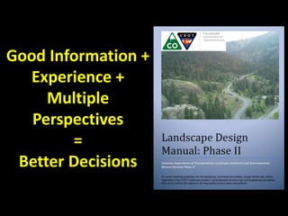
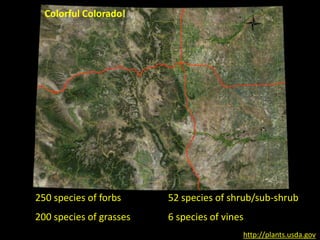
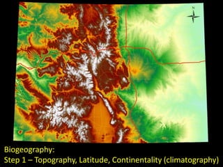
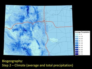
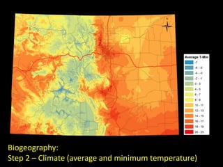
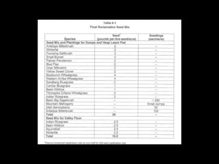
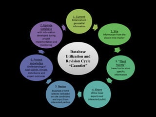
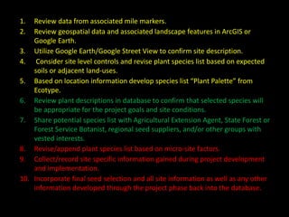
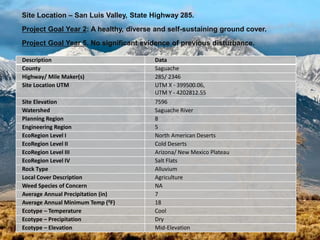
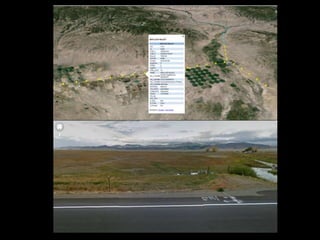
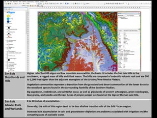
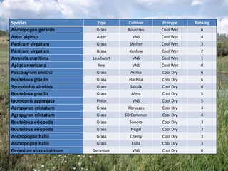
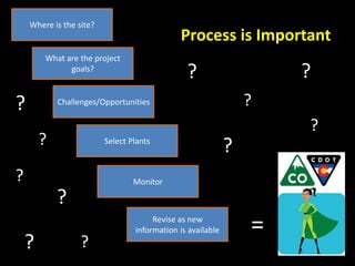
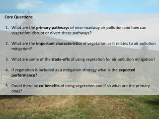
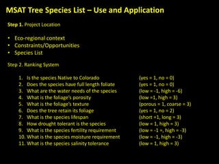
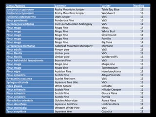
Christopher Peltz
chris@researchservicesco.com
Landscape Design Manual & Plant
Selection Guide for Colorado Roadways
Good Information +
Experience +
Multiple
Perspectives
=
Better Decisions
250 species of forbs
200 species of grasses
52 species of shrub/sub-shrub
6 species of vines
http://plants.usda.gov
Colorful Colorado!
Development Philosophy
“CDOT’s approach to transportation design requires that there be a
direct relationship between the proposed design and the place it will
be located “site context”. Defining design zones are critical to
creating a relationship between transportation and landscape, while
maintaining a consistent approach to design throughout the state.”
• Site Context – Physical, Climatic, Biological factors.
• Transportation/Landscape – Visual resources, Safety, Maintenance.
• Can this help the CDOT have better projects?
• Evolution
Purpose
Define the geographic extents of the physical, biological, and
ecological zones of Colorado and use this information to improve
restoration efforts by optimizing the plant selection process.
Goal
Develop a geographic dataset, based on all State of Colorado route
mile markers, and, associate specific land-use, climatic and biologic
attributes to each markers location.
Format
• Plant Selection Guide
• Spatial data (ESRI and Google Earth)
• Work flow/methods
Where to begin?
Biogeography:
Step 1 – Topography, Latitude, Continentality (climatography)
Biogeography:
Step 2 – Climate (average and total precipitation)
Biogeography:
Step 2 – Climate (average and minimum temperature)
Biogeography – Large Scale
Biogeography – Small Scale
Land-use/Land-cover
Database
Utilization and
Revision Cycle
“Gauntlet”
1. Review data from associated mile markers.
2. Review geospatial data and associated landscape features in ArcGIS or
Google Earth.
3. Utilize Google Earth/Google Street View to confirm site description.
4. Consider site level controls and revise plant species list based on expected
soils or adjacent land-uses.
5. Based on location information develop species list “Plant Palette” from
Ecotype.
6. Review plant descriptions in database to confirm that selected species will
be appropriate for the project goals and site conditions.
7. Share potential species list with Agricultural Extension Agent, State Forest or
Forest Service Botanist, regional seed suppliers, and/or other groups with
vested interests.
8. Revise/append plant species list based on micro-site factors.
9. Collect/record site specific information gained during project development
and implementation.
10. Incorporate final seed selection and all site information as well as any other
information developed through the project phase back into the database.
Description Data
County Saguache
Highway/ Mile Maker(s) 285/ 2346
Site Location UTM UTM X - 399500.06,
UTM Y - 4202812.55
Site Elevation 7596
Watershed Saguache River
Planning Region 8
Engineering Region 5
EcoRegion Level I North American Deserts
EcoRegion Level II Cold Deserts
EcoRegion Level III Arizona/ New Mexico Plateau
EcoRegion Level IV Salt Flats
Rock Type Alluvium
Local Cover Description Agriculture
Weed Species of Concern NA
Average Annual Precipitation (in) 7
Average Annual Minimum Temp (0F) 18
Ecotype – Temperature Cool
Ecotype – Precipitation Dry
Ecotype – Elevation Mid-Elevation
Site Location – San Luis Valley, State Highway 285.
Project Goal Year 2: A healthy, diverse and self-sustaining ground cover.
Project Goal Year 5. No significant evidence of previous disturbance.
San Luis
Shrublands and
Hills
Higher relief foothill edges and low mountain areas within the basin. It includes the San Luis Hills in the
southwest, a rugged mass of hills and tilted mesas. The hills are composed of andesitic volcanic rock and are 500
to 1,000 feet higher than the adjacent ecoregions of the Arizona/New Mexico Plateau.
Vegetation communities represent a transition from the grassland and desert communities of the lower basin to
the woodland species found in the surrounding foothills of the Southern Rockies.
Big sagebrush, rabbitbrush, and winterfat occur, as well as grasslands of western wheatgrass, green needlegrass,
blue grama, and needle-and-thread. Areas of pinyon-juniper are found on the tops of the San Luis Hills.
San Luis
Alluvial Flats
and Wetlands
8 to 10 inches of precipitation.
Generally, the soils of this region tend to be less alkaline than the soils of the Salt Flat ecoregion.
Increased salt accumulation in soils and groundwater depletion are problems associated with irrigation and the
competing uses of available water.
Species Type Cultivar Ecotype Ranking
Andropogon gerardii Grass Rountree Cool Wet 6
Aster alpinus Aster VNS Cool Wet 4
Panicum virgatum Grass Shelter Cool Wet 3
Panicum virgatum Grass Kanlow Cool Wet 2
Armeria maritima Leadwort VNS Cool Wet 1
Apios americana Pea VNS Cool Wet 0
Pascopyrum smithii Grass Arriba Cool Dry 6
Bouteloua gracilis Grass Hachita Cool Dry 6
Sporobolus airoides Grass Saltalk Cool Dry 6
Bouteloua gracilis Grass Alma Cool Dry 5
Ipomopsis aggregata Phlox VNS Cool Dry 5
Agropyron cristatum Grass Abruzzes Cool Dry 4
Agropyron cristatum Grass SD Common Cool Dry 4
Bouteloua eriopoda Grass Sonora Cool Dry 3
Bouteloua eriopoda Grass Nogal Cool Dry 3
Andropogon hallii Grass Cherry Cool Dry 3
Andropogon hallii Grass Elida Cool Dry 3
Geranium viscosissimum Geranium VNS Cool Dry 0
Where is the site?
What are the project
goals?
Challenges/Opportunities
Select Plants
Monitor
Revise as new
information is available
Process is Important
=
?
?
?
?
?
?
?
?
?
?
?
Mobile Source Air Toxics (MSAT) Tree Species Selection
Purpose
Develop a species list and design criteria for standalone vegetative barriers and
vegetation barriers located adjacent to sound barriers using regionally
appropriate trees and other vegetation types to reduce the impacts of Mobile-
Source Air Toxics (MSATs).
Core Questions
1. What are the primary pathways of near-roadway air pollution and how can
vegetation disrupt or divert these pathways?
2. What are the important characteristics of vegetation as it relates to air pollution
mitigation?
3. What are some of the trade-offs of using vegetation for air pollution mitigation?
4. If vegetation is included as a mitigation strategy what is the expected
performance?
5. Could there be co-benefits of using vegetation and if so what are the primary
ones?
Key Findings
1. Living barriers can reduce airborne particulates through surface capture,
deposition and dispersion.
2. Conifers are superior to deciduous trees for overall particulate removal
because of their year round foliage, greater amounts leaf and stem surface
area per unit of land and smaller boundary layer thickness.
3. Most studies show vegetation pollution removal at the scale of a city or
region is likely less than 2%.
4. Vegetation is only a temporary retention site for most atmospheric particles.
Most particles often re-suspend into the atmosphere, wash off with rain, or
drop to the ground with twig and leaf fall.
MSAT Tree Species List – Use and Application
Step 1. Project Location
• Eco-regional context
• Constraints/Opportunities
• Species List
Step 2. Ranking System
1. Is the species Native to Colorado (yes = 1, no = 0)
2. Does the species have full length foliate (yes = 1, no = 0)
3. What are the water needs of the species (low = -1, high = -6)
4. What is the foliage’s porosity (low =1, high = 3)
5. What is the foliage’s texture (porous = 1, coarse = 3)
6. Does the tree retain its foliage (yes = 1, no = 2)
7. What is the species lifespan (short =1, long = 3)
8. How drought tolerant is the species (low = 1, high = 3)
9. What is the species fertility requirement (low = -1 =, high = -3)
10. What is the species moisture requirement (low = -1, high = -3)
11. What is the species salinity tolerance (low = 1, high = 3)
Genus/Species Common Variety Ranking
Juniperus scopulorum Rocky Mountain Juniper Table Top Blue 16
Juniperus scopulorum Rocky Mountain Juniper Woodward 16
Juniperus osteosperma Utah Juniper VNS 15
Pinus ponderosa Ponderosa Pine VNS 15
Cercocarpus ledifolius Curl Leaf Mountain Mahogany VNS 14
Pinus mugo Mugo Pine Mops 14
Pinus mugo Mugo Pine White Bud 14
Pinus mugo Mugo Pine Slowmound 14
Pinus mugo Mugo Pine Pumilio 14
Pinus mugo Mugo Pine Big Tuna 14
Cercocarpus montanus Alderleaf Mountain Mahogany Montane 13
Pinus edulis Pinyon pine VNS 13
Pinus flexilis Limber pine VNS 13
Pinus flexilis Limber pine Vanderwolf’s 13
Pinus heldreichii leucodermis Bosnian Pine VNS 13
Pinus mugo Mugo pine Mugo pine 13
Pinus mugo Mugo pine Tannenbaum 13
Pinus nigra Austrian Pine Hornibrookiana 13
Pinus sylvestris Scotch Pine Albyn Prostrata 13
Pyracantha coccinea Scarlet Firethorn VNS 13
Syringa reticulata Japanese Tree Lilac VNS 13
Picea glauca White Spruce Densata 12
Pinus sylvestris Scotch Pine Hillside Creeper 12
Pinus sylvestris Scotch Pine Glauca Nana 12
Pinus sylvestris Scotch Pine Pumila 12
Platycladus orientalis Golden Arborvitae Aurea Nana 12
Pinus densiflora Japanese Red Pine Umbraculifera 11
Pinus monticola Western White Pine VNS 11
Taxus cuspidata Japanese Yew Capatita 11

Final Phase II Presentation 10-26-14

  • 1.
    Christopher Peltz chris@researchservicesco.com Landscape DesignManual & Plant Selection Guide for Colorado Roadways
  • 2.
    Good Information + Experience+ Multiple Perspectives = Better Decisions
  • 4.
    250 species offorbs 200 species of grasses 52 species of shrub/sub-shrub 6 species of vines http://plants.usda.gov Colorful Colorado!
  • 6.
    Development Philosophy “CDOT’s approachto transportation design requires that there be a direct relationship between the proposed design and the place it will be located “site context”. Defining design zones are critical to creating a relationship between transportation and landscape, while maintaining a consistent approach to design throughout the state.” • Site Context – Physical, Climatic, Biological factors. • Transportation/Landscape – Visual resources, Safety, Maintenance. • Can this help the CDOT have better projects? • Evolution
  • 7.
    Purpose Define the geographicextents of the physical, biological, and ecological zones of Colorado and use this information to improve restoration efforts by optimizing the plant selection process. Goal Develop a geographic dataset, based on all State of Colorado route mile markers, and, associate specific land-use, climatic and biologic attributes to each markers location. Format • Plant Selection Guide • Spatial data (ESRI and Google Earth) • Work flow/methods Where to begin?
  • 8.
    Biogeography: Step 1 –Topography, Latitude, Continentality (climatography)
  • 9.
    Biogeography: Step 2 –Climate (average and total precipitation)
  • 10.
    Biogeography: Step 2 –Climate (average and minimum temperature)
  • 11.
  • 12.
  • 13.
  • 15.
  • 16.
    1. Review datafrom associated mile markers. 2. Review geospatial data and associated landscape features in ArcGIS or Google Earth. 3. Utilize Google Earth/Google Street View to confirm site description. 4. Consider site level controls and revise plant species list based on expected soils or adjacent land-uses. 5. Based on location information develop species list “Plant Palette” from Ecotype. 6. Review plant descriptions in database to confirm that selected species will be appropriate for the project goals and site conditions. 7. Share potential species list with Agricultural Extension Agent, State Forest or Forest Service Botanist, regional seed suppliers, and/or other groups with vested interests. 8. Revise/append plant species list based on micro-site factors. 9. Collect/record site specific information gained during project development and implementation. 10. Incorporate final seed selection and all site information as well as any other information developed through the project phase back into the database.
  • 17.
    Description Data County Saguache Highway/Mile Maker(s) 285/ 2346 Site Location UTM UTM X - 399500.06, UTM Y - 4202812.55 Site Elevation 7596 Watershed Saguache River Planning Region 8 Engineering Region 5 EcoRegion Level I North American Deserts EcoRegion Level II Cold Deserts EcoRegion Level III Arizona/ New Mexico Plateau EcoRegion Level IV Salt Flats Rock Type Alluvium Local Cover Description Agriculture Weed Species of Concern NA Average Annual Precipitation (in) 7 Average Annual Minimum Temp (0F) 18 Ecotype – Temperature Cool Ecotype – Precipitation Dry Ecotype – Elevation Mid-Elevation Site Location – San Luis Valley, State Highway 285. Project Goal Year 2: A healthy, diverse and self-sustaining ground cover. Project Goal Year 5. No significant evidence of previous disturbance.
  • 19.
    San Luis Shrublands and Hills Higherrelief foothill edges and low mountain areas within the basin. It includes the San Luis Hills in the southwest, a rugged mass of hills and tilted mesas. The hills are composed of andesitic volcanic rock and are 500 to 1,000 feet higher than the adjacent ecoregions of the Arizona/New Mexico Plateau. Vegetation communities represent a transition from the grassland and desert communities of the lower basin to the woodland species found in the surrounding foothills of the Southern Rockies. Big sagebrush, rabbitbrush, and winterfat occur, as well as grasslands of western wheatgrass, green needlegrass, blue grama, and needle-and-thread. Areas of pinyon-juniper are found on the tops of the San Luis Hills. San Luis Alluvial Flats and Wetlands 8 to 10 inches of precipitation. Generally, the soils of this region tend to be less alkaline than the soils of the Salt Flat ecoregion. Increased salt accumulation in soils and groundwater depletion are problems associated with irrigation and the competing uses of available water.
  • 20.
    Species Type CultivarEcotype Ranking Andropogon gerardii Grass Rountree Cool Wet 6 Aster alpinus Aster VNS Cool Wet 4 Panicum virgatum Grass Shelter Cool Wet 3 Panicum virgatum Grass Kanlow Cool Wet 2 Armeria maritima Leadwort VNS Cool Wet 1 Apios americana Pea VNS Cool Wet 0 Pascopyrum smithii Grass Arriba Cool Dry 6 Bouteloua gracilis Grass Hachita Cool Dry 6 Sporobolus airoides Grass Saltalk Cool Dry 6 Bouteloua gracilis Grass Alma Cool Dry 5 Ipomopsis aggregata Phlox VNS Cool Dry 5 Agropyron cristatum Grass Abruzzes Cool Dry 4 Agropyron cristatum Grass SD Common Cool Dry 4 Bouteloua eriopoda Grass Sonora Cool Dry 3 Bouteloua eriopoda Grass Nogal Cool Dry 3 Andropogon hallii Grass Cherry Cool Dry 3 Andropogon hallii Grass Elida Cool Dry 3 Geranium viscosissimum Geranium VNS Cool Dry 0
  • 21.
    Where is thesite? What are the project goals? Challenges/Opportunities Select Plants Monitor Revise as new information is available Process is Important = ? ? ? ? ? ? ? ? ? ? ?
  • 22.
    Mobile Source AirToxics (MSAT) Tree Species Selection Purpose Develop a species list and design criteria for standalone vegetative barriers and vegetation barriers located adjacent to sound barriers using regionally appropriate trees and other vegetation types to reduce the impacts of Mobile- Source Air Toxics (MSATs).
  • 23.
    Core Questions 1. Whatare the primary pathways of near-roadway air pollution and how can vegetation disrupt or divert these pathways? 2. What are the important characteristics of vegetation as it relates to air pollution mitigation? 3. What are some of the trade-offs of using vegetation for air pollution mitigation? 4. If vegetation is included as a mitigation strategy what is the expected performance? 5. Could there be co-benefits of using vegetation and if so what are the primary ones?
  • 24.
    Key Findings 1. Livingbarriers can reduce airborne particulates through surface capture, deposition and dispersion. 2. Conifers are superior to deciduous trees for overall particulate removal because of their year round foliage, greater amounts leaf and stem surface area per unit of land and smaller boundary layer thickness. 3. Most studies show vegetation pollution removal at the scale of a city or region is likely less than 2%. 4. Vegetation is only a temporary retention site for most atmospheric particles. Most particles often re-suspend into the atmosphere, wash off with rain, or drop to the ground with twig and leaf fall.
  • 25.
    MSAT Tree SpeciesList – Use and Application Step 1. Project Location • Eco-regional context • Constraints/Opportunities • Species List Step 2. Ranking System 1. Is the species Native to Colorado (yes = 1, no = 0) 2. Does the species have full length foliate (yes = 1, no = 0) 3. What are the water needs of the species (low = -1, high = -6) 4. What is the foliage’s porosity (low =1, high = 3) 5. What is the foliage’s texture (porous = 1, coarse = 3) 6. Does the tree retain its foliage (yes = 1, no = 2) 7. What is the species lifespan (short =1, long = 3) 8. How drought tolerant is the species (low = 1, high = 3) 9. What is the species fertility requirement (low = -1 =, high = -3) 10. What is the species moisture requirement (low = -1, high = -3) 11. What is the species salinity tolerance (low = 1, high = 3)
  • 26.
    Genus/Species Common VarietyRanking Juniperus scopulorum Rocky Mountain Juniper Table Top Blue 16 Juniperus scopulorum Rocky Mountain Juniper Woodward 16 Juniperus osteosperma Utah Juniper VNS 15 Pinus ponderosa Ponderosa Pine VNS 15 Cercocarpus ledifolius Curl Leaf Mountain Mahogany VNS 14 Pinus mugo Mugo Pine Mops 14 Pinus mugo Mugo Pine White Bud 14 Pinus mugo Mugo Pine Slowmound 14 Pinus mugo Mugo Pine Pumilio 14 Pinus mugo Mugo Pine Big Tuna 14 Cercocarpus montanus Alderleaf Mountain Mahogany Montane 13 Pinus edulis Pinyon pine VNS 13 Pinus flexilis Limber pine VNS 13 Pinus flexilis Limber pine Vanderwolf’s 13 Pinus heldreichii leucodermis Bosnian Pine VNS 13 Pinus mugo Mugo pine Mugo pine 13 Pinus mugo Mugo pine Tannenbaum 13 Pinus nigra Austrian Pine Hornibrookiana 13 Pinus sylvestris Scotch Pine Albyn Prostrata 13 Pyracantha coccinea Scarlet Firethorn VNS 13 Syringa reticulata Japanese Tree Lilac VNS 13 Picea glauca White Spruce Densata 12 Pinus sylvestris Scotch Pine Hillside Creeper 12 Pinus sylvestris Scotch Pine Glauca Nana 12 Pinus sylvestris Scotch Pine Pumila 12 Platycladus orientalis Golden Arborvitae Aurea Nana 12 Pinus densiflora Japanese Red Pine Umbraculifera 11 Pinus monticola Western White Pine VNS 11 Taxus cuspidata Japanese Yew Capatita 11