The document discusses several topics related to road design and traffic safety:
1) It analyzes the need for road safety audits and reviews for new road projects and major reconstructions, and argues they should be mandatory to help engineers incorporate modern safety concepts.
2) It proposes defining "autovias" (limited-access highways in Argentina) and establishing design criteria for access control, connections to collector roads, and progressive improvements to meet autopista standards over time.
3) It analyzes the appropriate width for median barriers on divided highways, arguing narrow medians are sufficient for safety while wider medians proposed in Argentina have failed due to excessive costs and issues accommodating road elements.
This document summarizes the results of a project in Germany that aimed to determine road and traffic variables that influence overtaking maneuvers and related crashes. An analysis of crash data from five German states identified 500 rural road sections most prone to overtaking crashes. Factors found to influence overtaking crashes included road design (curves, sight distances), traffic regulations (overtaking restrictions, speed limits), and driver behavior (misjudging gaps). Recommendations are made to prevent overtaking crashes through infrastructure improvements and traffic measures that improve sight distances and driver awareness of hazards.
This document discusses several proposals and countermeasures to improve road safety in Argentina. It includes 6 topics for discussion: 1) Professional training for road safety engineers and road safety audits, 2) Relationship between geometric design standards and road safety - mathematical models, 3) Definitions of highway, semi-highway, motorway regarding number of lanes, 4) Median width for divided roadways, 5) International evolution of single-lane roundabouts, and 6) Safer roads according to predominant or exclusive vehicle types. The document is a draft for discussion and debate, presenting personal opinions of the authors. It provides background on road safety audits and reviews in Argentina and proposes making them mandatory for new projects or major road reconstructions.
This document presents a study of different bypass route solutions around the towns of Alcantara de Jucar, Cárcer and Cotes in Valencia Province, Spain. Four alternative routes were proposed and evaluated based on multi-criteria analyses of economic, road safety, and environmental impact factors. The analyses considered attributes like earthworks, expropriations, structures required, road length, visibility, access points, connections to other roads, impact on protected land and livestock routes, proximity to buildings and developable land, flood risk, and expected service level. The recommended solution adopted for further development as a basic project was the alternative route determined to have the lowest overall score across the factor and attribute evaluations.
This document discusses solutions for improving roadside safety related to utility poles. It begins by providing context on the safety issues posed by utility poles located near roads. It then describes three categories of solutions: 1) keeping vehicles on the roadway through measures like pavement markings and wider shoulders; 2) relocating or removing poles by increasing setbacks, combining utilities on shared poles, or burying lines; and 3) using safety devices like breakaway poles, guardrails, or concrete barriers. The document emphasizes that the optimal design uses as few poles as practical in low-risk locations. It also notes that while removing poles would eliminate crashes, the cost is a major consideration.
The document discusses efficient solutions for traffic systems, focusing on applications for roads. It describes how SICK solutions are used for (1) monitoring electronic toll collection through 3D laser scanning and automation light grids to classify vehicles, (2) red light and speed monitoring using laser-based sensors, and (3) ensuring traffic safety with solutions for clearance measurement, hot spot detection, and more.
http://www.hcmguide.com/index.htm
This case study investigates a situation at the University of Florida regarding the impacts of a new parking structure on Museum Road in Gainesville, Florida. The increased traffic to and from the new structure would access this facility via a two-way stop-controlled intersection, but alternatives are being analyzed to determine the best solution for this and adjacent intersections along Museum Road. Pedestrian, bicycle, and transit-related activities are high within this section of Museum Road, and so the solution must be sensitive to and consider all travel modes.
This document summarizes a seminar presentation about roundabouts. The presentation discussed why roundabouts are safer than traditional intersections with traffic signals or stop signs, providing statistics showing large reductions in crashes and injuries at roundabouts. It covered design elements of modern roundabouts that contribute to safety, such as deflection and low entry speeds. The presentation also addressed concerns about pedestrian, bicyclist, and visually impaired accessibility at roundabouts and showed how well-designed roundabouts can improve safety and traffic flow for all users. A brief history of roundabout development in various countries was presented as well.
The document discusses the preliminary studies required for the geometric design of roads, including their classification, basic design criteria, engineering considerations, and standards. It covers analyzing demand and terrain, conducting surveys, studying hydrology, geology, environment and safety. The goal is to design roads appropriately based on capacity and standards according to road classification and terrain conditions.
This document presents the results of a traffic volume study conducted at an intersection in Sincelejo, Colombia. The study had general and specific objectives, including calculating flow rates, determining the peak demand hour, and analyzing the influence of motorcycles. Field procedures involved strategically placing counters to manually count vehicles in 5-minute periods over 2 hours. Office procedures included totaling counts, identifying peak volumes and hours, and graphically representing traffic variations. Results will help plan solutions if congestion issues are identified. The practice provided experience with traffic studies that will benefit students' future work.
This document summarizes the 2010 update to Argentina's highway geometric design standards. It was commissioned by the Argentina National Highway Administration in 2009 and developed over 12 months by the Civil Engineering Mountain School of San Juan National University. The update was needed to incorporate new knowledge on how highway design impacts traffic safety and operation since the previous 1967/80 standards. It covers topics like clear zones, sight distances, roundabouts, and justification of safety devices. The update was informed by reviews of international standards and input from local and foreign engineering experts. While published, the updated standards have not been formally adopted.
Briefly, I am Ashish Shrivastava (self employed), Piping stress engineer with 15+ years of experience. I have done wide range of stress analysis in different sectors like Offshore/onshore, Marine, LNG/LPG, Petrochemical, Solar/ Thermal powerplants. Please find my profiles attached here for your reference.
I would be grateful if you can consider my profile for Autocad plant 3D/ pipe stress analysis work that would like to outsource.
I also provide corporate trainings online/offline.
Nazmy Markos has over 34 years of experience in mechanical engineering, project management, and cost estimating for oil and gas pipeline and facility projects. He has extensive experience performing engineering design, stress analysis, hydraulic studies, and cost estimating for pipeline projects including pipelines, pumping stations, compressor stations, and tank farms. Some of the projects he has worked on include pipelines and facilities for TransCanada, Enbridge, Kinder Morgan, and Syncrude.
This document presents the analysis of improving the intersection of State Route 96 and X Street. It contains existing conditions of the intersection including traffic volumes and level of service. Two alternatives are analyzed to improve the level of service for the projected 2033 traffic volumes. Alternative 1 adds additional lanes to each approach. Alternative 2 changes the signal phasing to group approaches differently. Both alternatives are able to achieve acceptable levels of service through 2033 based on the analysis in the tables provided. Vertical and horizontal geometric designs as well as pavement design are also discussed to accommodate the projected traffic.
This document summarizes a presentation on dynamic lane guidance. It discusses using intelligent transport systems for cooperation and automation through tactical driving advice provided to vehicles. This could involve providing speed, headway and lane use advice to vehicles based on real-time traffic state estimation integrating data from vehicles, roadside infrastructure and traffic management centers. The presentation examines requirements and challenges for achieving lane-level positioning accuracy needed for such advice, and shows simulation results of dynamic lane guidance systems reducing travel time delays on highways by influencing traffic flow dynamics.
Intersection CONCEPTUAL DESIGN Methodology, by Grant Johnson PE PTOEGrant Johnson, PE
It starts with analysis. Synchro Pro. Then a common sense approach to building an intersection design that follows analysis. First learn the traffic patterns, and then maximize flow rates and capacity by designing smart. Not smart growth, but smart design based on common sense and putting resources like lanes and signal timing where it is most needed, eliminating waste in design. True problem solving.
Diagnostic load testing of bridges - case studies Eva Lantsoght
This document summarizes diagnostic load testing performed on two new bridges in Ecuador: the Los Pajaros Bridge and ramps at the La Armenia Interchange. Load testing involved placing trucks weighing up to 2400kN (60% of design load) in various positions to model different load cases. Deflections were measured and compared to computational models. For both bridges, measured deflections closely matched predictions, validating the bridge designs and indicating they were ready for traffic. In conclusion, diagnostic load testing is an important way to verify bridge designs by comparing real responses to models.
The document summarizes a student presentation about converting a disused railway into a greenway in London, UK. It describes exploring two potential sites before selecting the Belmont Trail for its development potential and support. The project involved designing the greenway's geometry, pavement, and a community center using CAD software. Design considerations included grades, curves, sight lines, drainage and ADA accessibility. The presentation covered the existing conditions, design process, proposed site plans and some building details.
CV_Electrical and Instrumentation EngineerDeva Narayanan
This document contains the resume of Deva Narayanan, an Electrical and Instrumentation Engineer with over 6.5 years of experience in the oil and gas industry. It details his professional experience with two companies, roles and responsibilities, achievements, professional skills in both design and instrumentation, computer skills, personal attributes, education, and projects executed. His experience includes engineering, design, procurement, testing, and site support for projects in metering, solar, chemical injection, and wellhead control panels.
A traffic engineering firm conducted a capacity review of a proposed single lane roundabout at the intersection of SR 28 and Coon Street in Kings Beach, California using 2008 traffic volumes. Their analysis using RODEL software found that at a 50th percentile confidence level, the roundabout would operate at Level of Service C, but at an 85th percentile confidence level, which accounts for urban factors, it would operate at Level of Service F with significant delays. They determined that a single lane roundabout would not have adequate capacity based on the 2008 traffic volumes and urban conditions at this intersection.
Forum presentation #4 innovative signal control at mlk cve5022 c-5110c_finNathan Baker
The document summarizes a presentation on innovative signal control for an intersection in Uptown Cincinnati. It analyzed the existing traffic conditions and performance of the pre-timed signal control, which was found to have long delays. An alternative with actuated signal control and geometric changes was modeled and found to improve traffic flow. An adaptive traffic signal control system was also proposed, which uses algorithms to adjust signal timing in response to real-time traffic conditions. Modeling showed this approach could reduce delays and increase speeds compared to the existing control system. The presentation concluded with recommendations to further optimize the adaptive system and evaluate impacts and costs of implementation.
The document discusses roadside design and clear zone concepts. It defines clear zone as the total roadside area available for safe use by errant vehicles. It emphasizes removing hazards from the clear zone where possible, and using guardrails to protect from fixed objects that cannot be removed. Key factors in determining clear zone width include design speed, traffic volume, and slope geometry. The document also discusses treatments for hazardous areas such as removing, relocating, breaking the fall of, or delineating hazards. It provides guidance on proper use, length, and installation of guardrails to reduce impact severity from hazards that cannot be removed from the clear zone.
The document proposes updates to the subdivision code regarding street widths and the review process. It suggests establishing two standard street designs - a narrow section with 28 feet of pavement and a wide section with 36 feet. It also proposes a three-tiered review process where minor variations would only require administrative approval while more significant changes would require a waiver reviewed by the Planning Commission. The goal is to introduce more flexibility for applicants while simplifying the review process.
The document describes the facilities and operations of an airport terminal. It outlines the organizational structure and responsibilities of various divisions including terminal facilities, engineering, operations, security systems, baggage handling systems, and track transit systems. It provides details on the maintenance and operations of the terminal buildings, mechanical systems, electrical systems, and other infrastructure.
exit exam preparatiomn Login code: 92566. Do not give this code to anyone, even if they say they are from Telegram!
This code can be used to log in to your Telegram account. We never ask it for anything else.
If you didn't request this code by trying to log in on another device, simply ignore this message.
Presentation by Dr James Tate at Institute of Air Quality Management (IAQM) Dispersion Modellers User Group December 2014.
www.its.leeds.ac.uk/people/j.tate
http://iaqm.co.uk/event/dmug-2014/
Title: Level of Service F for Grade A Streets
Track: Prosper
Format: 90 minute panel
Abstract: Relying solely on Level of Service criteria for street design, which evaluates vehicle congestion, leads to poor outcomes on many of our roadways. LOS F, far from a failure, creates opportunities to reallocate roadway space for more livable street designs. In this session, learn about projects in Cambridge and San Francisco that overcame opposition and generated community support in prioritizing better bicycling and walking over vehicle capacity during the peak hour of travel.
Presenters:
Presenter: Michael Sallaberry San Francisco Municipal Transportation Agency
Co-Presenter: Jeffrey Rosenblum City of Cambridge, MA
El 28 de abril de 2015 la Fundación Ramón Areces, con la colaboración de Ineco, organizó un
encuentro de divulgación sobre la metodología BIM (Building Information Modelling), en la que participaron los principales representantes del sector nacional de infraestructuras.building, arquitecture, construcción, arquitectura, ingeniería, obras públicas, tecnología, technology, economía, economy
Similar to C IT ANI MEDIDAS Y CONTRAMEDIDAS MEJOR SV 100p.pdf (20)
Este documento presenta un manual de diseño geométrico vial para Abu Dhabi. El objetivo es estandarizar las prácticas de diseño vial en el emirato y mejorar la seguridad y operación de la red vial. El manual se basa en prácticas internacionales y provee criterios para el diseño de autopistas, caminos rurales y calles urbanas. También cubre elementos como alineación horizontal y vertical, intersecciones, rotondas y distribuidores. El manual tiene como objetivo guiar el diseño de nuevas vías y reconstrucciones princip
Este documento presenta un resumen de la primera edición de la Guía de diseño de bordes de carretera de Abu Dhabi publicada en diciembre de 2016. Incluye 13 capítulos que describen el enfoque basado en el desempeño para el diseño seguro de bordes de carretera, el cálculo de la zona clara, la identificación de peligros, y las opciones de tratamiento. El documento también explica que la guía se basa en las pruebas NCHRP350 y MASH en lugar de los estándares europeos EN13
The document provides an introduction to the Abu Dhabi Roadside Design Guide. It discusses the background and purpose of developing uniform roadside design standards and guidelines for Abu Dhabi. It outlines the key approaches taken in the guide, including using a performance-based rather than prescriptive approach, emphasizing proprietary rather than non-proprietary systems, adopting American testing standards over European ones, and using a single testing standard. The scope of the guide is also summarized, covering topics like the risk mitigation process, clear zone concepts and calculations, hazard identification, passively safe design, and descriptions of different barrier types.
Este documento presenta la tabla de contenido de la primera edición de diciembre de 2016 de la Guía de diseño de bordes de carretera de Abu Dhabi. La guía cubre temas como el enfoque de mitigación de riesgos, el cálculo de la zona clara, la identificación de peligros, las estructuras de soporte, las barreras de seguridad, los sistemas de protección para motociclistas, los terminales, los cojines amortiguadores y las transiciones. La tabla de contenido enumera 13 capítulos
Este documento presenta un resumen del Manual de Seguridad Vial (MSV) en sus primeras 5 secciones:
1. El propósito del MSV es proporcionar herramientas para fundamentar decisiones sobre seguridad vial mediante información cuantitativa.
2. Antes del MSV, los profesionales no tenían un recurso para obtener datos sobre choques. El MSV llena este vacío proveyendo métodos para estimar choques.
3. La primera edición del MSV surgió de sesiones en la Junta de Investigación de
Este documento presenta el Manual de Seguridad Vial 2009. El propósito del manual es proveer herramientas analíticas para cuantificar los efectos potenciales sobre los choques como resultado de decisiones en planificación, diseño, operaciones y mantenimiento de caminos. El manual no establece un estándar legal, sino que ayuda a agencias a integrar seguridad en la toma de decisiones. El manual está dirigido a profesionales del transporte para realizar análisis de seguridad de manera técnicamente sólida y mejorar las decisiones bas
Este documento describe un estudio que evalúa el impacto de los límites de velocidad variables recomendados en la capacidad y nivel de servicio de las autopistas. Presenta una metodología estadística para comparar las condiciones de tránsito antes y después de la implementación de los límites de velocidad variables usando datos recopilados de la autopista E4 en Estocolmo. Los resultados indican que los límites de velocidad variables recomendados no tuvieron un impacto significativo en las condiciones del tránsito, tanto
Este documento presenta una guía de diseño de caminos de Abu Dhabi. Explica que la guía tiene un enfoque basado en el desempeño en lugar de uno prescriptivo. Se compone de 13 capítulos que cubren temas como el enfoque de mitigación de riesgos, el cálculo de la zona despejada, la identificación de peligros, las barreras de seguridad y sus terminales y amortiguadores. El objetivo es mejorar la seguridad vial mediante un diseño de caminos centrado en el riesgo.
Este documento presenta una tabla de contenido detallada para la primera edición de diciembre de 2016 de la Guía de diseño de bordes de carretera de Abu Dhabi. La tabla de contenido describe los 13 capítulos que comprenden la guía, incluidos los enfoques de mitigación de riesgos, el cálculo de la zona clara, la identificación de peligros, las estructuras de soporte, las barreras de seguridad, los sistemas de protección para motociclistas, los terminales y los cojines antichoque.
Este documento presenta una tabla de contenido detallada para la primera edición de diciembre de 2016 de la Guía de diseño de bordes de carretera de Abu Dhabi. La tabla de contenido describe los 13 capítulos que comprenden la guía, incluidos los enfoques adoptados, el ámbito, los conceptos clave como la zona clara y la identificación de peligros, y la descripción y selección de barreras de seguridad, terminales y cojines antichoque. La guía proporciona directrices para el diseño seguro
Este documento presenta la tabla de contenido de la primera edición de diciembre de 2016 de la Guía de diseño de bordes de carretera de Abu Dhabi. Incluye 13 capítulos que cubren temas como el enfoque de mitigación de riesgos, el cálculo de la zona despejada, la identificación de peligros en la carretera, estructuras de soporte seguras y transitable, terminales y diseño urbano de carreteras. El documento proporciona una introducción general y una descripción del alcance de
El documento describe la historia y propósito del Manual de Seguridad Vial (HSM). El HSM proporciona herramientas para evaluar la seguridad en proyectos de transporte considerando factores como la frecuencia y gravedad de accidentes. Antes no había un recurso nacional para este tipo de análisis cuantitativo. El HSM fue desarrollado por un grupo de trabajo de TRB y AASHTO para llenar este vacío y mejorar la toma de decisiones en seguridad vial.
El documento presenta una introducción al Manual de Seguridad Vial (MSV). El MSV provee herramientas analíticas para cuantificar los efectos potenciales sobre los choques como resultado de las decisiones tomadas en la planificación, diseño, operaciones y mantenimiento viales. El MSV está destinado a profesionales del transporte para realizar análisis de seguridad de forma técnicamente sólida y coherente, mejorando así las decisiones basadas en el rendimiento de seguridad. La introducción describe el propósito, público objetivo,
El documento presenta una introducción al Manual de Seguridad Vial (MSV). El MSV provee herramientas analíticas para cuantificar los efectos potenciales sobre los choques como resultado de las decisiones tomadas en la planificación, diseño, operaciones y mantenimiento de caminos. El MSV está destinado a ser un recurso para profesionales del transporte a nivel estatal, de condado y local para realizar análisis de seguridad de una manera técnicamente sólida y mejorar las decisiones basadas en la seguridad. La introducción describe
El documento presenta una introducción al Manual de Seguridad Vial (MSV). El MSV provee herramientas analíticas para cuantificar los efectos potenciales sobre los choques como resultado de las decisiones tomadas en la planificación, diseño, operaciones y mantenimiento viales. El MSV está destinado a profesionales del transporte para realizar análisis de seguridad de forma técnicamente sólida y coherente, mejorando así las decisiones basadas en el rendimiento de seguridad. La introducción describe el propósito, público objetivo,
artificial intelligence and data science contents.pptxGauravCar
What is artificial intelligence? Artificial intelligence is the ability of a computer or computer-controlled robot to perform tasks that are commonly associated with the intellectual processes characteristic of humans, such as the ability to reason.
› ...
Artificial intelligence (AI) | Definitio
Electric vehicle and photovoltaic advanced roles in enhancing the financial p...IJECEIAES
Climate change's impact on the planet forced the United Nations and governments to promote green energies and electric transportation. The deployments of photovoltaic (PV) and electric vehicle (EV) systems gained stronger momentum due to their numerous advantages over fossil fuel types. The advantages go beyond sustainability to reach financial support and stability. The work in this paper introduces the hybrid system between PV and EV to support industrial and commercial plants. This paper covers the theoretical framework of the proposed hybrid system including the required equation to complete the cost analysis when PV and EV are present. In addition, the proposed design diagram which sets the priorities and requirements of the system is presented. The proposed approach allows setup to advance their power stability, especially during power outages. The presented information supports researchers and plant owners to complete the necessary analysis while promoting the deployment of clean energy. The result of a case study that represents a dairy milk farmer supports the theoretical works and highlights its advanced benefits to existing plants. The short return on investment of the proposed approach supports the paper's novelty approach for the sustainable electrical system. In addition, the proposed system allows for an isolated power setup without the need for a transmission line which enhances the safety of the electrical network
Optimizing Gradle Builds - Gradle DPE Tour Berlin 2024Sinan KOZAK
Sinan from the Delivery Hero mobile infrastructure engineering team shares a deep dive into performance acceleration with Gradle build cache optimizations. Sinan shares their journey into solving complex build-cache problems that affect Gradle builds. By understanding the challenges and solutions found in our journey, we aim to demonstrate the possibilities for faster builds. The case study reveals how overlapping outputs and cache misconfigurations led to significant increases in build times, especially as the project scaled up with numerous modules using Paparazzi tests. The journey from diagnosing to defeating cache issues offers invaluable lessons on maintaining cache integrity without sacrificing functionality.
Introduction- e - waste – definition - sources of e-waste– hazardous substances in e-waste - effects of e-waste on environment and human health- need for e-waste management– e-waste handling rules - waste minimization techniques for managing e-waste – recycling of e-waste - disposal treatment methods of e- waste – mechanism of extraction of precious metal from leaching solution-global Scenario of E-waste – E-waste in India- case studies.
Redefining brain tumor segmentation: a cutting-edge convolutional neural netw...IJECEIAES
Medical image analysis has witnessed significant advancements with deep learning techniques. In the domain of brain tumor segmentation, the ability to
precisely delineate tumor boundaries from magnetic resonance imaging (MRI)
scans holds profound implications for diagnosis. This study presents an ensemble convolutional neural network (CNN) with transfer learning, integrating
the state-of-the-art Deeplabv3+ architecture with the ResNet18 backbone. The
model is rigorously trained and evaluated, exhibiting remarkable performance
metrics, including an impressive global accuracy of 99.286%, a high-class accuracy of 82.191%, a mean intersection over union (IoU) of 79.900%, a weighted
IoU of 98.620%, and a Boundary F1 (BF) score of 83.303%. Notably, a detailed comparative analysis with existing methods showcases the superiority of
our proposed model. These findings underscore the model’s competence in precise brain tumor localization, underscoring its potential to revolutionize medical
image analysis and enhance healthcare outcomes. This research paves the way
for future exploration and optimization of advanced CNN models in medical
imaging, emphasizing addressing false positives and resource efficiency.
Batteries -Introduction – Types of Batteries – discharging and charging of battery - characteristics of battery –battery rating- various tests on battery- – Primary battery: silver button cell- Secondary battery :Ni-Cd battery-modern battery: lithium ion battery-maintenance of batteries-choices of batteries for electric vehicle applications.
Fuel Cells: Introduction- importance and classification of fuel cells - description, principle, components, applications of fuel cells: H2-O2 fuel cell, alkaline fuel cell, molten carbonate fuel cell and direct methanol fuel cells.
C IT ANI MEDIDAS Y CONTRAMEDIDAS MEJOR SV 100p.pdf
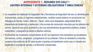
1. ANTECEDENTE 1 - RESUMEN XVII CAVyT 1
ASV/RSV INTERNAS Y EXTERNAS OBLIGATORIAS Y SIMULTÁNEAS
4
La necesidad de Auditorias de Seguridad Vial y Revisiones de Seguridad Vial son un demérito para
el proyectista, quizás un ingeniero experimentado, recibido cuando todavía no se conocían los
hallazgos de Stonex, Leisch, Glennon, Hauer, sobre zona despejada, peligrosidad de los
dispositivos de contención y redirección, o los errores de conducción inducidos por los defectos del
camino. Ignora lo que no le enseñaron y con sus conocimientos de geometría analítica, análisis
matemático, y topografía se dedicó a diseñar caminos.
Al difundirse los novedosos conocimientos de SV, los ingenieros más estudiosos se actualizaron
con lecturas, cursos, congresos, y progresaron en su profesión. Otros se retrasaron y entonces
surgieron las auditorías de SV para ayudar a quienes principalmente creían que un trazado era
excelente si la poligonal cerraba, o el Brückner compensaba.
2. RESUMEN XVII CAVyT 2
ASV/RSV INTERNAS Y EXTERNAS OBLIGATORIAS Y SIMULTÁNEAS
5
Con una actualización de los programas de diseño vial, con el acento en la SV, la profesión de
auditor no existiría. Es como si un médico después de recibido tuviera que pedir ayuda a la
enfermera para que le enseñe a tomar la presión o aplicar una inyección; lo cual ignoraría si no se lo
enseñaron. Además, si dos o tres de sus proyectos son sometidos a auditorías, a la cuarta ya
debería haber asimilado todo los conceptos de SV, y aplicarlos.
Para acelerar la difusión de los conocimientos de SV mientras se actualizan los programas
universitarios de grado y posgrado, este trabajo propone que las ASV y RSV sean OBLIGATORIAS
PARA CADA PROYECTO NUEVO O GRAN RECONSTRUCCIÓN DE CAMINO EXISTENTE, por
parte de un auditor calificado e INDEPENDIENTE, lo cual sería una auditoría externa, de un
proyecto que debió además ser internamente auto auditado por el proyectista, que para ser tal
debería tener título habilitante como el del auditor externo.
5. La velocidad directriz guía el diseño de los alineamientos horizontal y vertical según los principios
físicos de equilibrio dinámico de un vehículo en movimiento curvo, y distancia visual de detención en
curvas verticales, según modelos matemáticos racionales cuyos coeficientes se ajustan según
resultados y observaciones de experiencias de campo que los investigadores realizan con
actualizadas herramientas de medición de velocidad, desaceleración, distancia de frenado, fricción
neumático-calzada, peralte, inclinación lateral del vehículo, medidas con riguroso control.
Para una dada velocidad directriz, teniendo en cuenta adecuados coeficientes de seguridad, en
curvas horizontales, teóricamente el equilibrio dinámico se alcanza para una amplia gama de
combinaciones de valores prácticos de radios, peraltes y fricciones.
Para analizar las variables Velocidad, Radio, Peralte, Fricción Transversal y Longitud de transición, y
entender mejor cómo se relacionan, se plantearon cuatro monografías conexas y complementarias:
15
ANTECEDENTE 2 - RESUMEN XVII CAVyT 1
RELACIÓN NORMAS DISEÑO GEOMÉTRICO Y SEGURIDAD VIAL
6. Rectas
Vaivenes de la fricción longitudinal. Adenda AASHO’70. Libro Verde 2001.
Curvas
Equilibrio dinámico: peso + fuerza centrífuga = peralte + fricción
Distribución del peralte.
Radio mínimo absoluto (tensión de rotura)
Concepto racional de AASHO (Barnett), Rühle.
Fricción nula para velocidad de la mayoría
Libros Azul / Verde de AASHTO y DNV’67
Ingeniero Moreno (EICAM) - El esotérico R3 anula el propósito expresado.
Radio mínimo deseable según A10
Velocidad inferida y máxima segura crítica
Ejemplo CHVL 130 → 80 km/h 19
12. 26
FACTOR HUMANO – EXPECTATIVAS
El equilibrio dinámico no garantiza la coherencia de diseño
Factor humano – Expectativas
La gradualidad entre el cielo y el infierno no es el purgatorio, es el infierno con
esperanza: relación R1/R2 curvas sucesivas y los choques.
Criterios de seguridad de Lamm
15. 3. AUTOPISTA – SEMIAUTOPISTA – AUTOVÍA
– MULTICARRIL – TRICARRIL – DIETA VIAL
“Habitualmente, las rutas argentinas se cobran
decenas de víctimas en dantescos accidentes;
en la imagen, 14 gendarmes muertos en la ruta 3
de dos manos, en Chubut.
(...) La Argentina tiene un promedio de 18,8
muertos cada 100.000 habitantes, Suecia, solo
3.”
LA NACIÓN, 24.2.15, http://goo.gl/Zl0G6p
Acción psicológica habitual de interesados
‘voceros’:
- Toda parecería indicar que el camionero
(muerto) se durmió.
- Llovía torrencialmente, como nunca en la vida
- Parecería haber sido un atentado con fusil o
miguelitos.
31
16. Ley 24449 Art. 5 Definiciones de caminos de calzadas divididas; autopistas y
semiautopistas.
Características esenciales: Separación Física Calzadas – Control Acceso Total o
Parcial – Intersecciones = o ≠ nivel
En LA NACIÓN la palabra autovía apareció por primera vez el 26 de marzo de 1997. Dos años después de la Ley
24.449. A casi 20 años sin definición, las así llamadas conforman un verdadero cambalache..., el tourbillón junto al
retorno. Negación de la uniformidad de entradas y salidas, y del concepto pro seguridad vial de caminos
autoexplicativos.
Propuesta definición ‘Autovía.
Categoría 1 DNV’67 - Control parcial de acceso; ambigüedad
Confusiones oficiales – MÁS CAPACIDAD NO ES MAYOR SEGURIDAD
’Ejemplos locales RN14; RP6 - Comparación con expressways EUA, RU 32
17. RESUMEN XVII CAVyT 2
DUPLICACIONES DE CALZADA Y AUTOVÍAS SIN CONTROL DE ACCESO:
Insuficientes para Mejorar la Seguridad Vial
34
Se analizan además los criterios de diseños aplicados a las llamadas Autovías, no definidas por la
Ley de Tránsito, en relación a estas características.
En el trabajo técnico se analizarán:
Concepto de AUTOVÍA, comparación con los Caminos Expresos Rurales de los EUA
Limitaciones de los criterios de diseño en relación con la Seguridad Vial.
Prácticas adoptadas en la Argentina y otros países,
Criterios de diseño contrarios de las prácticas del estado del arte, que desvirtúen el propósito
buscado de mejorar la Seguridad Vial
Diseños de Autovías desarrollados sin un criterio de mejoramiento progresivo orientado a la
condición futura de Autopista,
Se propondrán: Criterios y medidas de diseño complementarios orientados al concepto de Obra
Básica con mejoramiento progresivo.
18. AUTOPISTA – SEMIAUTOPISTA AUTOVÍA
CONTROL TOTAL DE ACCESO CONTROL PARCIAL/NULO
MALVERSACIÓN DE FONDOS PÚBLICOS
https://goo.gl/kSdqMh
35
ADMINISTRACIÓN/CONTROL TOTAL/PARCIAL ACCESO
19. 36
ADMINISTRACIÓN TOTAL /
PARCIAL ACCESO
Porcentaje de choques en accesos a
propiedad según tipo de movimiento
Conveniencia de SV al entrar y salir a
colectora mediante giros-derecha
Right In – Right Out
20. 37
PROPUESTA DEFINICIÓN GEOMÉTRICA DE AUTOVÍA
Control Total Acceso: Deseable por lado, para frecuencia de accesos directos a
propiedad ≥ 2/km. Separación mínima 500 m; deseable 1000 m
Consolidar frecuencia al momento del Proyecto Definitivo
Distancia conexión calles colectoras con calzadas principales entre 1 y 5 km.
Admisible colectoras dos sentidos con carriles cambio de velocidad OB-2 derecha-
entrar/derecha salir. Ejemplo RN9 Av. Benavídez, Lajas.
21. RN7 Autovía Luján – SA de Giles
2x2 M=12 m T>1:4 - ACCESOS DIRECTOS s/Street View: (97.8-74.2) km = 23.6 km; 44i+31d
39
31. Autovía RP2 km 132 – Chascomús – 2x2 M=19 m – T > 1:4
51
PARECER VEROSÍMIL
DE LA NACIÓN. 11.1.15
Al parecer, un auto que iba
delante del micro realizó una
mala maniobra, por lo que el
chofer quiso esquivarlo y en
esas circunstancias perdió el
control del vehículo y cayó al
zanjón que separa ambas
manos de la autovía, donde
quedó volcado sobre su
costado izquierdo.
http://goo.gl/K2w5f9
32. 4. ANCHO DE MEDIANA CALZADAS DIVIDIDAS
MEDIANA ANGOSTA.
Argentina Avenida General Paz, Ricchieri, Acceso Norte + Ramales Tigre, Pilar,
Campana, Variante Escobar, Autopista BALP, Rosario-Santa Fe, Camino Buen Ayre,
Acceso Oeste Liniers-Luján.
Alemania, EUA, Canadá, Francia, Suecia,....
MEDIANA ANCHA
Plano Tipo OB-1: funciones zona-despejada de recuperación y ampliación carriles
(M = 21.5/16 m) FRACASO por:
Taludes ≥ 1:4, hueco entre puentes y alcantarillas, iluminación central, barandas
metálicas TL-1, estaciones de servicios, puentes y viaductos angostos para
ampliar carriles; expropiaciones costosas NO redituables durante 45 años, ni
banquinas internas; Ejemplos. Cruces directos por falta de algunas colectoras.
RN9: Campana-Rosario-Córdoba; RP6; RN14; RP2; RN3 Ezeiza-Cañuela con
barandas y luminarias desde origen. 52
70. ANTECEDENTE 4.2 RESUMEN XVII CAVyT 1
GANADORES Y PERDEDORES POR LA RESOLUCIÓN Nº 0254/97 DE LA DNV: NORMAS PARA EL INGRESO
Y EGRESO A ESTACIONES DE SERVICIO DESDE AUTOPISTAS B) ESTACIONES DE SERVICIO A UBICAR
ENTRE LAS DOS CALZADAS DE LA AUTOPISTA
93
1. Antecedentes y fundamentos de la Resolución DNV Nº 0254/97.
2. Contradicción de términos, se exige condición segura de maniobras comprobadamente peligrosas:
2.1. Al salir y entrar en las calzadas principales desde las Estación de Servicio: Entrecruzamiento entre
autos y camiones con unos 50 km/h de diferencia de velocidad permitida.
2.2. Al entrar en las calzadas principales punto ciego visual conductor de espejo retrovisor lado
acompañante que le impide ver los claros en el tránsito por el carril rápido.
71. 95
Aspectos técnicos y legales de la
DNV Resolución Nº 254/97 + Plano tipo OB-2.
Actualización de DNV Res. 135/88 por Peticiones terceros para ingresos y egresos
a ES con o sin prestaciones complementarias en ZC autopista CARÁCTER
PRECARIO. Nada obsta usar atribuciones conferidas.
Prioridad circulación autopista: VD, OB-2, > 6m, R >1500 m.
https://goo.gl/QdvPkJ
Propuesta de volver a las fuentes con barrera rígida continua de TL-4 comprobado.
72. 96
Obstáculo o peligro para normal fluidez del tránsito
Medidas de seguridad para el usuario – Uso espacio aéreo sin peligro para el
tránsito
Funcionamiento servicios esenciales
Primeros auxilios, comunicaciones o abastecimientos previstas en el proyecto
Garantías de seguridad al usuario
Prohibidos puestos de control permanente; sí primeros auxilios o comunicaciones
no peligrosos para el tránsito
Ley 24.449 Art. 27 Construcciones
Permanentes o Transitorias en Zona
de Camino
73. 8.1.12 Accesos a instalaciones comerciales
Estaciones de Servicio en Autopistas
Texto adaptado de la Nota Circular Nº 2955/97 y Resolución Nº 0254/97
de la DNV:
NORMAS PARA EL INGRESO Y EGRESO A ESTACIONES DE
SERVICIO DESDE AUTOPISTAS [Bibliografía Particular BP C8 (01)], con
omisión de las secciones:
B) ESTACIONES DE SERVICIO A UBICAR ENTRE LAS DOS CALZADAS
DE LA AUTOPISTA,
C) ESTACIONES DE SERVICIO A UBICAR EN LA ZONA DE CAMINO
ENTRE LA CALZADA Y LA COLECTORA
E) PRESENTACIÓN DE LA DOCUMENTACIÓN TÉCNICA. 97
A10 – Capítulo 8 (1)
74. Las estaciones de servicio (ES) sólo podrán ubicarse fuera de la
zona de camino, con adecuados accesos según la clasificación
funcional del camino; desde la calzada principal a la estación de
servicio, o desde la calzada principal a la colectora y desde la
colectora a la estación de servicio. Particularmente en las
autopistas esto significa que las estaciones de servicio no podrán
instalarse en la mediana ni entre calzadas principales y calles
colectoras. El terreno para las instalaciones necesarias será
comprado o alquilado por el interesado, bajo su exclusiva
responsabilidad, sin ningún compromiso por parte de la DNV.
98
A10 – Capítulo 8 (2)
78. Plano Tipo DNV OB-2 Espejado Horizontalmente S / Res. DNV 254/97
102
▲ENTRECRUZAMIENTO DE CARRIL RÁPIDO DE CAMIONES
LENTOS EN SALIDAS Y ENTRADAS DE CALZADA MULTICARRIL
▼PUNTO CIEGO ESPEJO RETROVISOR LEJANO EN ENTRADA A
CALZADA MULTICARRIL
79. 103
ESTACIÓN DE SERVICIO EN MEDIANA ANCHA
Vista Plano Tipo DNV OB-2 Espejado Horizontalmente S / Res. DNV 254/97
81. Las RM de dos o más carriles
aumentan la capacidad, pero no
tanto la seguridad, al aparecer el
entrecruzamiento y más puntos
de conflicto que con un carril
operando como una serie de n
vías colectoras-distribuidoras.
Rotondas Modernas Multicarriles
105
82. 106
ESTO NO ES UNA ROTONDA MODERNA
ES UNA ROTATORIA DE DISEÑO OBSOLETO – RN14 km 101
http://goo.gl/iDv0rl 5 muertos + > 50 heridos 8.2.16
83. 107
ESTO TAMPOCO
San Isidro - Informe
Preliminar Intersección
Márquez – Rolón – Fleming
https://goo.gl/CL6v3K
84. 108
NI ESTO
RN14 km 101, RP6xRP53;
RP2, Alpargatas,
N193xRP6, NI ...∞.
Diseños según capacidad HCM en función de entrecruzamiento; NO seguridad
85. RESUMEN XVII CAVyT 2
APLICACIONES DE LAS ROTONDAS MODERNAS POS A10
Novedades salientes en la aplicación de las rotondas modernas desde el año 2010 en que se aprobó el Informe Final de la
Actualización A10 DNV – EICAM con su Capítulo 5 – Sección 5.5 ROTONDAS MODERNAS
https://goo.gl/UNUAEz
110
Rotondas vs Semáforos. Comparación
CMF Rotondas vs Intersección semaforizada.
Turborrotondas en Corredores de Rotondas
Guías: NCHRP 672 2010.
Tendencias actuales en los diámetros de las RM respecto de la A10
Corredores de rotondas desde el punto de vista de la Administración de Accesos
Ejemplos de Corredores de RM en los EUA.
Semiautopistas, Autovías, aporte para alcanzar definiciones consensuadas.
86. 111
Serie o Corredores de rotondas;
RM entre semáforos; Semáforo entre RM. Ventajas de un carril sobre multicarril.
20000 vpd – Vía C-D - Entrecruzamiento
Mala fama local por confusión con rotatorias o círculos de tránsito.
89. 6. CAMINO MÁS SEGURO - SEGÚN TIPO DE
VEHÍCULO PREVALECIENTE O EXCLUSIVO
115
Variante Paso por Campana – Zárate
para tránsito liviano hasta camión simple
El arco, la cuerda y las flechas.
Riesgos camino existente; puntos negros
característicos, agravamiento paulatino;
extensión zona urbanizada.
Propuesta de estudio de factibilidad
DNV/DVBA según la cuerda entre ríos
Luján y Areco, y espuela desde RN8 km
46 Ramal Pilar Estación Panamericana
del FCGB hasta río Luján y entre RN9 km
102.7 y Central Atucha + Parque Energía
Nuclear.
▲ RN9 KM 75 CAMPANA
90. ANTECEDENTE 6 - RESUMEN XVII CAVyT 1
PROPUESTA: DNV ESTUDIO DE FACTIBILIDAD TÉCNICO ECONÓMICO Y SEGURIDAD - CONEXIÓN VIAL ESTACIÓN
PANAMERICANA FCB RN8 KM 46 – DIAMANTE ATUCHA RN9 km 102.7 - Variante Paso por Campana – Zárate, Vehículos Livianos
116
1 PLANIMETRÍA GENERAL
2 PAUTAS GENERALES
Línea de Referencia
Espuela: Existente: RN8 km 46 – Calle Caamaño – Verazi - RP 25 – Calle Tagle – Subtotal 6 km
Nuevo: Calle Tagle – Puente Río Luján – Subtotal 9 km
Variante: Nuevo: Trompeta RN9 km 57.5 – Puente Río Luján – RP4 – RP6 – Aº Morejón – RP193 –
RN193 – FCU – RP31 – Diamante Atucha RN9 km 102.7 – Subtotal 50 km
Vehículos: Metrobús, Vehículos de pasajeros, livianos, de alta ocupación, micro-ómnibus, camiones
simples, vehículos de alta ocupación (VAO),
“only car”, unicidad de función (“one way, one function”)
Intersecciones a nivel tipo rotondas modernas
RP25, Río Luján, RP4, RP193, RN193, + intersección caminos vecinales
91. RESUMEN XVII CAVyT 2
PROPUESTA: DNV ESTUDIO DE FACTIBILIDAD TÉCNICO ECONÓMICO Y SEGURIDAD - CONEXIÓN VIAL ESTACIÓN
PANAMERICANA FCB RN8 KM 46 – DIAMANTE ATUCHA RN9 km 102.7 - Variante Paso por Campana – Zárate, Vehículos Livianos
Puentes: Río Luján - FCGU
Distribuidores: Trompeta en RN9 km 57.5 – Diamante cruce RP6
Tipo de camino: Según Estudio de Factibilidad (TMDA) construcción por etapas (tiempo y espacio), desde común
2x1 hasta Autovía (2x2 + control parcial de acceso) o Semiautopista (2x2 + control total de acceso), pasando por
camino-parque 3C o 2x2 con mediana de 5 m y serie de rotondas modernas con control total de acceso. Velocidad
directriz 110 km/h; límite señalizado máximo 100 km/h.
3 BENEFICIOS PREVISTOS
Seguridad Vial: al separar el tránsito liviano del pesado, en particular de los puntos negros de concentración de
accidentes mortales según datos provistos por el OCCOVI en el 2012, se reducirán los choques, y las congestiones
en el peligroso paso urbano por Campana – Zárate entre km 60 y 90.
Tiempo de viaje: desde y hasta Estación Panamericana, sustancialmente menor, por menor distancia de recorrido.
4 OPORTUNIDAD
El creciente desarrollo urbano entre Río Luján y RN193 hacia el sudoeste hará cada vez más difícil o imposible
encontrar una franja relativamente favorable como para no afectar valiosas propiedades.
117
94. 120
ACR km 75 Paso por Campana – PUNTO NEGRO
PUNTO NEGRO RN9 KM 75
Rosario ▲
Rosario ▼
DECANO PUNTO NEGRO ACR
KM75 PASO POR CAMPANA
OTROS: KM 56, 65.5, 73, 77-78, 81,...