1) Environmental science connects information from natural sciences, social sciences, and humanities to understand how nature works, how the environment affects us, how we affect the environment, and how to deal with environmental problems sustainably.
2) There are four basic causes of environmental problems: population growth, wasteful resource use, poverty, and failure to include environmental costs in market prices.
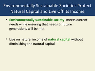
3) Sustainability requires living off the income generated by natural capital without diminishing the natural capital itself.
Accuracy assessment is an important part of any classification project. It compares the classified image to another data source that is considered to be accurate or ground truth data. Ground truth can be collected in the field; however, this is time consuming and expensive. Ground truth data can also be derived from interpreting high-resolution imagery, existing classified imagery, or GIS data layers.
The most common way to assess the accuracy of a classified map is to create a set of random points from the ground truth data and compare that to the classified data in a confusion matrix. Although this is a two-step process, you may need to compare the results of different classification methods or training sites, or you may not have ground truth data and are relying on the same imagery that you used to create the classification. To accommodate these other workflows, this process uses three geoprocessing tools: Create Accuracy Assessment Points, Update Accuracy Assessment Points, and Compute Confusion Matrix.
Thresholding
Thresholding is the process of identifying the pixels in a classified image that are the most likely to be classified incorrectly. These pixels are put into another class (usually class 0). These pixels are identified statistically, based upon the distance measures
that were used in the classification decision rule.
Accuracy Assessment : Error Matrix
Accuracy assessment is a general term for comparing the classification to geographical data that are assumed
to be true, in order to determine the accuracy of the classification process. Usually, the assumed-true data are derived from ground truth data. It is usually not practical to ground truth or otherwise test every pixel of a classified image. Therefore, a set of reference pixels is usually used. Reference pixels are points on the classified image for which actual data are (or will be) known. The reference pixels are randomly selected.
Overall accuracy: Overall accuracy is used to indicate the accuracy of whole classification (i.e. number of correctly classifier pixels divided by the total number of pixels in the error matrix)
User’s accuracy(commission error): User’s accuracy is regarded as the probability that a pixel classified on map actually represents that
class on the ground or reference data
Producer’s accuracy(omission error): Producer’s accuracy represents the probability of reference pixel being correctly classified
THIS PRESENTATION IS TO HELP YOU PERFORM THE TASK STEP BY STEP.
To meet the various information requirements in forest management, different data sources like field survey, aerial photography, and satellite imagery is used, depending on the level of detail required and the extension of the area under study.
Presentation held by Emma Bowa, Care International, at the learning event the Community Based Adaptation and Resilience in East and Southern Africa’s Drylands, held in Addis Abeba, Ethiopia by Care International Adaptation Learning Program for Africa (ALP), The CGIAR research program on Climate change, Agriculture and Food Security (CCAFS) and African Insect Science for Food and Health (ICIPE)
Welcome to our ultimate guide to Geographical Information System (GIS). Discover how GIS revolutionizes data analysis, mapping.
Explore the comprehensive guide to Geographical Information System (GIS). Learn about GIS benefits, applications, and implementation. Click here to uncover the potential.
A Geographical Information System (GIS) is a computer-based tool used to capture, store, manipulate, analyse, and present spatial or geographic data. It combines various types of data such as maps, satellite imagery, aerial photographs, and tabular data to create layers of information that can be visualized and analysed in relation to their geographic location.
GIS technology allows users to explore, interpret, and understand patterns and relationships within geographic data. It provides a framework for organizing and managing data, enabling users to query and retrieve specific information based on spatial and non-spatial attributes. GIS can be used in various fields, including urban planning, natural resource management, environmental assessment, transportation, agriculture, and emergency management
Criteria and indicators of sustainable forest management in Montenegro, SN…Franc Ferlin
This document has been drafted within the national working group (consisting of Alija Bralic, Zehra Demic, Blazo Jokanovic, Dragan Markovic, Kenan Pepic, Dragan Terzic, Joveta Terzic, and Zarko Vucinic) and harmonized by Milosav Anđelić, assistant minister, under my expert guidelines, facilitation and preparation of consolidated final text for publishing. The document has also been endorsed by the Minister (in 2012) as a regulation / rulebook, based on the Forest law. The monograph published in Montenegrin and English.
There are many different means of investigating the landslide-prone areas. Two types of landslide hazard evaluation methods are available. One is the direct observation and the other one is the use of technological tools. One of the guiding principles of geology is that the past is the key to the future. In evaluating landslide hazards, the future slope failures could occur as a result of the same geologic, geomorphic, and hydrologic situations that led to past and present failures. Based on this assumption, it is possible to estimate the types, frequency of occurrence, extent, and consequences of slope failures that may occur in the future. A landslide susceptibility map goes beyond an inventory map and depicts areas that have the potential for landsliding.
Statistics for Geography and Environmental Science:an introductory lecture c...Rich Harris
A sample of the instructor's resources to support the textbook Statistics for Geography and Environmental Science. Further information at www.social-statistics.org
The multidisciplinary nature of environmental studies and natural resources Maitry Agrawal
The multidisciplinary nature of environmental studies and natural resources presentation will help you in knowing the actual meaning of environmental studies and it's scope and importance in layman's language. we will be also discussing about natural resources, types, individual's role in conservation of natural resources and sustainability.
Palestine last event orientationfvgnh .pptxRaedMohamed3
An EFL lesson about the current events in Palestine. It is intended to be for intermediate students who wish to increase their listening skills through a short lesson in power point.
This is a presentation by Dada Robert in a Your Skill Boost masterclass organised by the Excellence Foundation for South Sudan (EFSS) on Saturday, the 25th and Sunday, the 26th of May 2024.
He discussed the concept of quality improvement, emphasizing its applicability to various aspects of life, including personal, project, and program improvements. He defined quality as doing the right thing at the right time in the right way to achieve the best possible results and discussed the concept of the "gap" between what we know and what we do, and how this gap represents the areas we need to improve. He explained the scientific approach to quality improvement, which involves systematic performance analysis, testing and learning, and implementing change ideas. He also highlighted the importance of client focus and a team approach to quality improvement.
We all have good and bad thoughts from time to time and situation to situation. We are bombarded daily with spiraling thoughts(both negative and positive) creating all-consuming feel , making us difficult to manage with associated suffering. Good thoughts are like our Mob Signal (Positive thought) amidst noise(negative thought) in the atmosphere. Negative thoughts like noise outweigh positive thoughts. These thoughts often create unwanted confusion, trouble, stress and frustration in our mind as well as chaos in our physical world. Negative thoughts are also known as “distorted thinking”.
Welcome to TechSoup New Member Orientation and Q&A (May 2024).pdfTechSoup
In this webinar you will learn how your organization can access TechSoup's wide variety of product discount and donation programs. From hardware to software, we'll give you a tour of the tools available to help your nonprofit with productivity, collaboration, financial management, donor tracking, security, and more.
2024.06.01 Introducing a competency framework for languag learning materials ...Sandy Millin
http://sandymillin.wordpress.com/iateflwebinar2024
Published classroom materials form the basis of syllabuses, drive teacher professional development, and have a potentially huge influence on learners, teachers and education systems. All teachers also create their own materials, whether a few sentences on a blackboard, a highly-structured fully-realised online course, or anything in between. Despite this, the knowledge and skills needed to create effective language learning materials are rarely part of teacher training, and are mostly learnt by trial and error.
Knowledge and skills frameworks, generally called competency frameworks, for ELT teachers, trainers and managers have existed for a few years now. However, until I created one for my MA dissertation, there wasn’t one drawing together what we need to know and do to be able to effectively produce language learning materials.
This webinar will introduce you to my framework, highlighting the key competencies I identified from my research. It will also show how anybody involved in language teaching (any language, not just English!), teacher training, managing schools or developing language learning materials can benefit from using the framework.
Ethnobotany and Ethnopharmacology:
Ethnobotany in herbal drug evaluation,
Impact of Ethnobotany in traditional medicine,
New development in herbals,
Bio-prospecting tools for drug discovery,
Role of Ethnopharmacology in drug evaluation,
Reverse Pharmacology.
Unit 8 - Information and Communication Technology (Paper I).pdfThiyagu K
This slides describes the basic concepts of ICT, basics of Email, Emerging Technology and Digital Initiatives in Education. This presentations aligns with the UGC Paper I syllabus.
2. Environmental Science Is a Study of
Connections in Nature (1)
• Environment:
• Everything around us
• “The environment is everything that isn’t me.“
• Environmental science: interdisciplinary science
connecting information and ideas from
• Natural sciences: ecology, biology, geology,
chemistry…
• Social sciences: geography, politics, economics
• Humanities: ethics, philosophy
3. Environmental Science Is a Study of
Connections in Nature (2)
• How nature works
• How the environment affects us
• How we affect the environment
• How to deal with environmental problems
• How to live more sustainably
4. Nature’s Survival Strategies Follow
Three Principles of Sustainability
1. Reliance on solar energy
• The sun provides warmth and fuels photosynthesis
2. Biodiversity
• Astounding variety and adaptability of natural
systems and species
3. Chemical cycling
• Circulation of chemicals from the environment to
organisms and then back to the environment
• Also called nutrient cycling
6. Sustainability Has Certain Key
Components
• Natural capital: supported by solar capital
• Natural resources: useful materials and energy in nature
• Natural services: important nature processes such as renewal of
air, water, and soil
• Humans degrade natural capital
• Scientific solutions needed for environmental sustainability
10. Some Sources Are Renewable and
Some Are Not (1)
• Resource
• Anything we obtain from the environment to meet
our needs
• Some directly available for use: sunlight
• Some not directly available for use: petroleum
• Perpetual resource
• Solar energy
11. Some Sources Are Renewable and
Some Are Not (2)
• Renewable resource
• Several days to several hundred years to renew
• E.g., forests, grasslands, fresh air, fertile soil
• Sustainable yield
• Highest rate at which we can use a renewable
resource without reducing available supply
12. Some Sources Are Renewable and
Some Are Not (3)
• Nonrenewable resources
• Energy resources
• Metallic mineral resources
• Nonmetallic mineral resources
• Reuse
• Recycle
15. Countries Differ in Levels of
Unsustainability (1)
• Economic growth: increase in output of a nation’s
goods and services
• Gross domestic product (GDP): annual market value
of all goods and services produced by all businesses,
foreign and domestic, operating within a country
• Per capita GDP: one measure of economic
development
16. Countries Differ in Levels of
Unsustainability (2)
• Economic development: using economic growth to
raise living standards
• More-developed countries: North America,
Australia, New Zealand, Japan, most of Europe
• Less-developed countries: most countries in Africa,
Asia, Latin America
18. We Are Living Unsustainably
• Environmental degradation: wasting, depleting, and
degrading the earth’s natural capital
• Happening at an accelerating rate
• Also called natural capital degradation
20. Pollution Comes from a Number of
Sources (1)
• Sources of pollution
• Point sources
• E.g., smokestack
• Nonpoint sources
• E.g., pesticides blown into the air
• Main type of pollutants
• Biodegradable
• Nondegradable
• Unwanted effects of pollution
21. Pollution Comes from a Number of
Sources (2)
• Pollution cleanup (output pollution control)
• Pollution prevention (input pollution control)
24. Overexploiting Shared Renewable
Resources: Tragedy of the Commons
• Three types of property or resource rights
• Private property (owned by someone)
• Common property (owned by large group, parks)
• Open access renewable resources (owned by nobody,
atmosphere, groundwater, open ocean)
• Tragedy of the commons
• Common property and open-access renewable
resources degraded from overuse
• Solutions? (Laws, convert to private)
25. Ecological Footprints: A Model of
Unsustainable Use of Resources
• Ecological footprint: the amount of biologically
productive land and water needed to provide the
people in a region with indefinite supply of
renewable resources, and to absorb and recycle
wastes and pollution
• Per capita ecological footprint
• Unsustainable: footprint is larger than biological
capacity for replenishment
32. Natural Systems Have Tipping Points
• Ecological tipping point: an often irreversible shift in
the behavior of a natural system
• Environmental degradation has time delays between
our actions now and the deleterious effects later
• Long-term climate change
• Over-fishing
• Species extinction
34. Cultural Changes Have Increased Our
Ecological Footprints
• 12,000 years ago: hunters and gatherers
• Three major cultural events
• Agricultural revolution
• Industrial-medical revolution
• Information-globalization revolution
• Current need for a sustainability revolution
36. Experts Have Identified Four Basic
Causes of Environmental Problems
1. Population growth
2. Wasteful and unsustainable resource use
3. Poverty
4. Failure to include the harmful environmental costs
of goods and services in market prices
38. Affluence Has Harmful and Beneficial
Environmental Effects
• Harmful environmental impact due to
• High levels of consumption
• High levels of pollution
• Unnecessary waste of resources
• Affluence can provide funding for developing
technologies to reduce
• Pollution
• Environmental degradation
• Resource waste
39. Poverty Has Harmful Environmental
and Health Effects
• Population growth affected
• Malnutrition
• Premature death
• Limited access to adequate sanitation facilities and
clean water
43. Prices Do Not Include the Value of
Natural Capital
• Companies do not pay the environmental cost of
resource use
• Goods and services do not include the harmful
environmental costs
• Companies receive tax breaks and subsidies
• Economy may be stimulated but there may be a
degradation of natural capital
45. Different Views about Environmental
Problems and Their Solutions
• Environmental ethics: what is right and wrong with how we
treat the environment
• Planetary management worldview
• We are separate from and in charge of nature
• Stewardship worldview
• Manage earth for our benefit with ethical responsibility to be
stewards
• Environmental wisdom worldview
• We are part of nature and must engage in sustainable use
46. Environmentally Sustainable Societies Protect
Natural Capital and Live Off Its Income
• Environmentally sustainable society: meets current
needs while ensuring that needs of future
generations will be met
• Live on natural income of natural capital without
diminishing the natural capital
47. We Can Work Together to Solve
Environmental Problems
• Social capital
• Encourages
• Openness and communication
• Cooperation
• Hope
• Discourages
• Close-mindedness
• Polarization
• Confrontation and fear
48. Case Study: The Environmental
Transformation of Chattanooga, TN
• Environmental success story: example of building their social
capital
• 1960: most polluted city in the U.S.
• 1984: Vision 2000-1,700 citizens came together to identify
issues, set goals, and find solutions
• 1995: most goals met-lowered emissions, started recycling
program, lowered air pollution levels, built new low-income
housing, businesses and people have started moving back
downtown
• 1993: Revision 2000-revitalizing South Chattanooga
50. Individuals Matter
• 5–10% of the population can bring about major
social change
• We have only 50-100 years to make the change to
sustainability before it’s too late
• Rely on renewable energy
• Protect biodiversity
• Reduce waste and pollution
53. Three Big Ideas
1. We could rely more on renewable energy from the sun, including
indirect forms of solar energy such as wind and flowing water, to
meet most of our heating and electricity needs.
2. We can protect biodiversity by preventing the degradation of the
earth’s species, ecosystems, and natural processes, and by
restoring areas we have degraded.
3. We can help to sustain the earth’s natural chemical cycles by
reducing our production of wastes and pollution, not overloading
natural systems with harmful chemicals, and not removing natural
chemicals faster than those chemical cycles can replace them.
Editor's Notes
Figure 1.3: T hree principles of sustainability. We derive these three interconnected principles of sustainability from learning how nature has sustained a huge variety of life on the earth for at least 3.5 billion years, despite drastic changes in environmental conditions ( Concept 1-1a ).
Figure 1.4: These key natural resources (blue) and natural services (orange) support and sustain the earth’s life and human economies ( Concept 1-1a ).
Figure 1.5: Nutrient cycling: This important natural service recycles chemicals needed by organisms from the environment (mostly from soil and water) through those organisms and back to the environment.
Figure 1.6: Natural capital degradation. This was once a large area of diverse tropical rain forest in Brazil, but it has now been cleared to grow soybeans. According to ecologist Harold Mooney of Stanford University, conservative estimates suggest that between 1992 and 2008, an area of tropical rain forest larger than the U.S. state of California was destroyed in order to graze cattle and plant crops for food and biofuels .
Figure 1.7: Reuse: This child and his family in Katmandu, Nepal, collect beer bottles and sell them for cash to a brewery that will reuse them.
Figure 1.8: Recycling: This family is carrying out items for recycling. Scientists estimate that we could recycle and reuse 80–90% of the resources that we now use and thus come closer to mimicking the way nature recycles essentially everything. Recycling is important but it involves dealing with wastes we have produced. Ideally, we should focus more on using less, reusing items, and reducing our unnecessary waste of resources.
Figure 2 This map shows high-income, upper-middle income, lower-middle-income, and low-income countries in terms of gross national income (GNI) PPP per capita (U.S. dollars) in 2008. (Data from World Bank and International Monetary Fund)
Figure 1.9: These are examples of the degradation of normally renewable natural resources and services in parts of the world, mostly as a result of rising populations and resource use per person.
Figure 1.10: This point-source air pollution rises from a pulp mill in New York State (USA).
Figure 1.11: The trash in this river came from a large area of land and is an example of nonpoint water pollution .
Figure 1.12: Patterns of natural resource consumption: The top photo shows a family of five subsistence farmers with all their possessions. They live in the village of Shingkhey, Bhutan, in the Himalaya Mountains, which are sandwiched between China and India in South Asia. The bottom photo shows a typical U.S. family of four living in Pearland, Texas, with their possessions .
Figure 1.13: Natural capital use and degradation. These graphs show the total and per capita ecological footprints of selected countries (top). In 2008, humanity’s total, or global, ecological footprint was at least 30% higher than the earth’s biological capacity (bottom) and is projected to be twice the planet’s biological capacity by around 2035. Question: If we are living beyond the earth’s renewable biological capacity, why do you think the human population and per capita resource consumption are still growing rapidly? (Data from Worldwide Fund for Nature, Global Footprint Network, Living Planet Report 2008. See www.footprintnetwork.org/en/index.php/GFn/page/world_footprin t/ )
Figure 7 This map shows the relative risk of tornados across the continental United States. (Data from NOAA)
Figure 1.14: Connections: This simple model demonstrates how three factors—number of people, affluence (resource use per person), and technology—affect the environmental impact of populations in less-developed countries (top) and more-developed countries (bottom).
Figure 1.15: In this example of a tipping point, you can control the ball as you push it up to the tipping point. Beyond that point, you lose control. Ecological tipping points can threaten all or parts of the earth’s life-support system.
Figure 1.16: Technological innovations have led to greater human control over the rest of nature and to an expanding human population.
Figure 1.18: Exponential growth: The J-shaped curve represents past exponential world population growth, with projections to 2100 showing possible population stabilization as the J-shaped curve of growth changes to an S-shaped curve. (This figure is not to scale.) (Data from the World Bank and United Nations, 2008; photo L. Yong/UNEP/Peter Arnold, Inc.)
Figure 1.19: Extreme poverty: This boy is searching through an open dump in Rio de Janeiro, Brazil, for items to sell. Many children of poor families who live in makeshift shantytowns in or near such dumps often scavenge most of the day for food and other items to help their families survive.
Figure 1.20: These are some of the harmful effects of poverty. Questions: Which two of these effects do you think are the most harmful? Why? (Data from United Nations, World Bank, and World Health Organization)
Figure 1.21: Global Outlook: One of every three children younger than age 5, such as this child in Lunda, Angola, suffers from severe malnutrition caused by a lack of calories and protein. According to the World Health Organization, each day at least 16,400 children younger than age 5 die prematurely from malnutrition and from infectious diseases often caused by drinking contaminated water.
Figure 1.22: This Hummer H3 sport utility vehicle burns a great deal of fuel compared to other, more efficient vehicles. It therefore adds more pollutants to the atmosphere and, being a very heavy vehicle, does more damage to the roads and land on which it is driven. It also requires more material and energy to build and maintain than most other vehicles on the road. These harmful costs are not included in the price of the vehicle.
Figure 1.23: Since 1984, citizens have worked together to make the city of Chattanooga, Tennessee, one of the best and most sustainable places to live in the United States.
Figure 1.24: Capturing wind power is one of the world’s most rapidly growing and least environmentally harmful ways to produce electricity.
Figure 1.25: This young child—like the grandchild of Emily and Michael in our fictional scenario of a possible future ( Core Case study )—is promoting sustainability by preparing to plant a tree. A global program to plant and tend billions of trees each year will help to restore degraded lands, promote biodiversity, and reduce the threat of climate change from atmospheric warming.