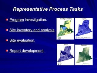
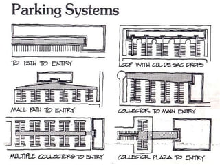
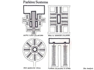
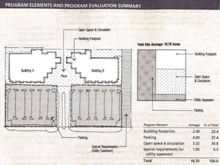
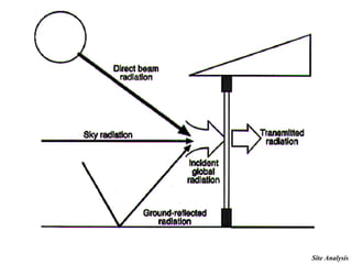
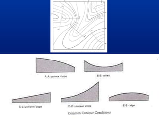
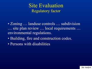
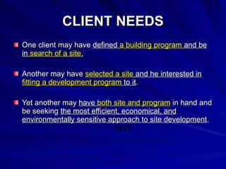
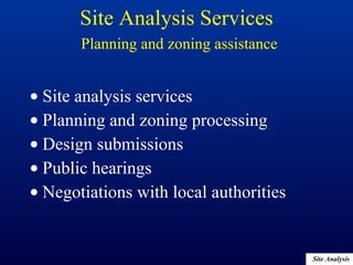
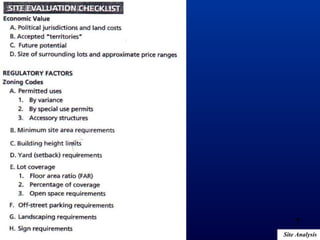
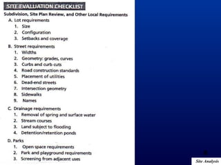
Site Analysis New Book 16.2 pp. 408-415
Site Analysis Part 1
Introduction Site analysis is a  vital step in the design process .  It involves the  evaluation of an existing or potential site  in relation to  the development program ,  environmental impact ,  impacts on the community  and  adjacent properties ,  project budget , and  schedule .
Introduction The site is an essential part of every project. Many firms offer  site evaluation and analysis  services as well as  zoning and planning assistance .
Introduction Site analysis is a vital first step in the design process. It includes: Evaluating  existing or potential  site. Relates it to the  program , the  budget , and the  schedule . Identifying  opportunities  and  constraints Identifying the appropriate  review agencies  and submittal requirements It gives  direction for design Site selection  and  program development Logical  and  sensitive   use  of land
Introduction Site analysis can be performed by: Interdisciplinary team Architects Landscape architects Planners Engineers Archaeologists Historians Lawyers Environmental scientists
Introduction The site analysis identifies  environmental, program, and development   constraints and opportunities.  A well-executed site analysis forms the  essential foundation for a cost-effective ,  environmentally sensitive , and  rational approach  to project development.
 
 
Why  a  Client May Need These Services To  evaluate development constraints and opportunities  for a site. To assess  one or more sites  as a basis for purchase. To assess the  infrastructure characteristics  of a site. To gain  information  as a basis for a zoning variance.
Knowledge and Skills Required   Knowledge of  climate, topography, soils, and natural features . Knowledge of  site utility distribution systems . Ability to evaluate  site access and circulation factors . Understanding of  building siting considerations . Familiarity with  planning and zoning ordinances . Ability to analyze  multiple factors objectively . Ability to work with  related or specialty disciplines .
Representative Process Tasks   Program  investigation. Site inventory and analysis . Site evaluation . Report development .
Program Evaluation Site analysis  requires  a  program  and a  site  to be  analyzed and evaluated  against each other. Are the site and the program  "right for each other"? PROGRAM SITE
 
Parking Requirements Parking capacity problems. Traffic issues can be even more troublesome than parking issues.
Parking requirements The biggest site requirement in many programs is the area necessary for parking. It is the function of  PROGRAM, ZONING,  or  REGULATIONS. Parking spaces per unit. Parking spaces per bed. Parking spaces per square meter (feet) of net or gross building area.
Area per car parking= ? m2 Parking requirements
Area per car = 30 to 40 m2  (325 to 450 square feet) Parking requirements
Parking area requirement= ? X ? Parking requirements
Parking requirements Parking area requirement=  Required number of parking spaces X  Area per car Area per car = 30 to 40 m2  (325 to 450 square feet)
Parking area requirement= Required number of parking spaces X  Area per car Parking requirements
Parking requirements Depends on: the configuration of the parking lot parking design number of compact and accessible spaces the extent of the landscaping within the parking lot the area given to entry and drop-off accessibility requirements


Site Analysis Part 2
Zoning Requirements FAR: Floor/Area Ration   FAR is the ratio of total allowable building area (square meter or feet) to the total area of the site. Ex. A site with a total area of 30,000 square meter and a mandated maximum FAR of 2:1 yields on an allowable building area of 60,000 square meter.
 
Pre-Design and Programming Division Revision
 
 
The FAR of the plot shown is 6. A new building is to use the maximum buildable area for each floor. How many floors can this building have? 6 7 8 9 3 m 3 m 3 m 5 m 42 m 34 m Land Buildable Area
The FAR of the plot shown is 5. A new building is to use the maximum buildable area for each floor. How many floors can this building have? 6 7 8 9 2 m 2 m 3 m 4 m 44 m 34 m Land Buildable Area
Building Coverage   Building Coverage is the percent of the site that is allowed to be covered by the building footprint. Ex. A site with a total area of 30,000 square meter and a mandated maximum Building Coverage of 50% allows a maximum building footprint of 15,000 square meter.  Zoning Requirements
Building Height   Building Height is the maximum allowable height for any building on a site.  This may be measured from  the first floor elevation or, the average grade around the base of the building Zoning Requirements
Building footprint The site coverage for a building. 3 variables: The total gross area of the building.   Net-to-gross area ration generally ranges from 60% to 95%.  The Number of floors.   Set by programmatic requirements, site area, and zoning requirements. The configuration of the building.   The building footprint on the site may vary from the average floor area.
 
Circulation and open space requirements Circulation areas : Area for pedestrian and vehicular circulation, access and common open spaces. Service docks and their access,  Auto circulation to parking areas,  Passenger drop-off areas, and pedestrian walkways.
Circulation and open space requirements Open spaces  include: Public open spaces such as parks and plazas. Landscape buffer areas at the periphery of the site. Detention/retention ponds. Unusable portions of the site such as slopes and wetlands.
Special constraints and requirements Utility easements (right of way) Rights-of-way Retention or sedimentation ponds Recreation areas Vistas and sight line requirements Floodplain areas Ecological preserves
Site Evaluation Physical Cultural Regulatory collecting and analyzing information walking the site and traversing its environs
Site Evaluation Climate A major determinant in building siting and orientation. Affects building  form, materials  and  subsystems. Affects building  construction technique.
Site Evaluation   Climate Wind Prevailing wind direction an velocities affects: the comfort level of outdoor spaces the energy efficiency of buildings structural loads exerted on structures, structural systems, as well as wall systems. Macro and Microclimatic factors include:
Site Evaluation   Climate Wind Building siting and orientation can be manipulated to maximize or minimize the effect of wind velocities.
Site Evaluation   Climate Solar orientation The sun's seasonal variation in altitude and azimuth and the average number of hours of daily sunshine are important factors affecting: form orientation energy efficiency materials exterior colors planting and shading functions of proposed elements siting of the building


Site Evaluation   Climate Temperature and humidity Sensation of heat =  Solar radiation +  Air temperature Human Comfort depends on the relationship of HEAT : WIND : HUMIDITY
Site Evaluation   Climate Precipitation Amounts, rates, forms, and drainage requirements of precipitation vary according to region and season. Precipitation affects: Load-bearing requirements of structural systems Foundation design The sizing and capacity of the mechanical systems Drainage networks of sites Construction schedule
Site Analysis Part 3
Site Evaluation   Topography, Legal Description, and Utility Survey Topographical characteristics Existing natural and artificial site elements Legal description Available utilities Topographic information and property line survey should be  current  and  bear the seal of a registered surveyor.
The  scale of the survey map  varies from 1:250 (1"=20') to 1:2500 (1"=200') depending on the size of the property and the detail of the site analysis. The  contour intervals  may be from 1' t 5' (30cm to 150cm) or greater depending on the scale of the base map and the topographic variations. Site Evaluation   Topography, Legal Description, and Utility Survey


Other site elements generally shown on a topographic map include: Vegetation and location of major trees. Rock outcroppings Lakes, streams, rivers, and marshes Man-made features such as roads, bridges, and buildings Site Evaluation   Topography, Legal Description, and Utility Survey


Boundary or property line surveys  show: Easements Rights-of-way Encumbrances on the site Defined acceptable land uses Points of access Buildable areas Site Evaluation   Topography, Legal Description, and Utility Survey
Utility surveys  show: Utilities existing on the site Location Size Elevation Site Evaluation   Topography, Legal Description, and Utility Survey
Legal descriptions  include : Easements and rights of way Acceptable land uses Points of access Buildable areas Site Evaluation   Topography, Legal Description, and Utility Survey
 
Affect the  economics  of development. Obtained from  soil surveys. Require the assistance of a  soil engineer  for interpretation. Geotechnical/soils Reports
Soil Reports , part of a soils surveys, contain: Depth of bedrock (if any) Elevation of water table (if any) variability and flow direction Bearing capacity of the soil Expansive nature of soils Location of fault lines (if any) Soils types Optimum moisture content for compaction Percolation rate (penetration)  Contamination from hazardous wastes (if any) Geotechnical/soil Reports
Implications: Engineered fill Building form Foundation and structural design Erosion potential Drainage Runoff Geotechnical/soil Reports
Affect the  economics  of development. Obtained from  soil surveys. Require the assistance of a  soil engineer  for interpretation. Site Evaluation Geotechnical/soils
Soil Reports , part of a soils surveys, contain: Depth of bedrock (if any) Elevation of water table (if any) variability and flow direction Bearing capacity of the soil Expansive nature of soils Location of fault lines (if any) Soils types Optimum moisture content for compaction Percolation rate (penetration)  Contamination from hazardous wastes (if any) Site Evaluation Geotechnical/soils
Implications: Engineered fill Building form Foundation and structural design Erosion potential Drainage Runoff Site Evaluation Geotechnical/soils
Elements: Storm and sanitary drainage Electrical Telephone Gas Water Cable television Site Evaluation Utilities and service
Implications: Site utilization Capacity may limit the building program The cost of expanding capacity may affect the economics of the project. Site Evaluation Utilities and service
Evaluation of potential environmental concerns: Phase 1: Historical research and observation Property history Governmental records On-site investigation Phase 2: Assessment of the presence of hazardous substances Physical testing of the site Improvements Adjoining properties Site Evaluation Environmental contamination
Each site is unique and presents special opportunities and challenges. Water elements Trees Rock outcroppings Views Special topographic features Site Evaluation Site character
Historical Political  Community context Site Evaluation Cultural factors
Site history Historic land uses and merits of existing structures. Historic uses may become important to the project. Site Evaluation Cultural factors
Surrounding land uses The surrounding area … the compatibility of the project and its program within the context of the existing community. Aesthetic … traffic … circulation … solar orientation … shading … vistas to and from the site. If the architect has a thorough knowledge of the community's composition, needs and concerns, the program and design can be developed in a manner that integrates the project with the surrounding community.  Site Evaluation Cultural factors


Economic value The economic value of the land … buildable area … steep  topography generally requires a larger investment in construction costs. Increasing the buildable area at increased construction cost may be economically feasible if the value of land and the increased return on development costs are high enough to outweigh the added investment.  Site Evaluation Cultural factors
Zoning … landuse controls … subdivision … site plan review … local requirements … environmental regulations. Building, fire and construction codes. Persons with disabilities Site Evaluation Regulatory factor
 
Site Analysis Part 4
Depends on: Owner's situation Project size Program complexity Site Analysis Services
CLIENT NEEDS One client may have  defined  a building program  and be in  search of a site . Another may have  selected a site  and he interested in  fitting a development program  to it . Yet another may  have  both site and program  in hand and be seeking  the most efficient, economical, and environmentally sensitive approach to site development . SITE
Site selection Often a client has a development program in mind and is looking for the best site for it.  Survey Evaluate To identify the best site based on the  physical, cultural, and regulatory characteristics  of the site and its surroundings. Site's  adaptability to and compatibility  with the proposed program. SITE
Program definition The client may have control of a site. Determine the development capacity of the site. Density,  Open space, and  Environmental quality  PROGRAM
The owner has both a defined program and a selected site. Maximize the potential of the site for its intended use. Site Analysis Services   Site accommodation
Combining the parameters of a selected site with the spatial needs of a project development program. How much development capacity does the site have? Site Analysis Services   Program definition
Building Program & Site Are the site and the program  "right for each other"? PROGRAM SITE
Development potential evaluation   Client already owns or is considering  Development potential and market value of the property
Special site studies   Utilities  studies Environmental impact  studies Historic resources  inventories Studies of  special opportunities .
Utilities studies Special opportunities Environmental impact studies Historic resources inventories Site Analysis Services   Special Site Studies
Site analysis services Planning and zoning processing Design submissions Public hearings Negotiations with local authorities Site Analysis Services   Planning and zoning assistance
Key scheduling questions: Is the site under the owner's  control  and, if not, when will it be? If the owner has an  option  (right) on the site, how long will it be in force? Can it be renewed? Is the owner paying  taxes  or other holding costs on the site? How will this affect the program development schedule? Are there easements or other  restrictions  on the full use of the site? How long will it take to resolve these? What  regulatory  approvals are required before construction can begin? Who grants them and what information do they require?  What will they cost the owner?  Site Analysis Services   Scheduling and budgeting
Key scheduling questions: What can be said about  the political climate  in which the project will be reviewed and approved? Will the project be  controversial ? Are there likely to be accommodations for neighbors or the community at large? Should these be considered from the outside? Site Analysis Services   Scheduling and budgeting
Preliminary estimate for: Site grading On-site utilities Utilities connections Off-site utilities work Drainage and retention ponds Paving and striping parking lots Site lighting Lawn and landscaping work Site furniture, including signage, seating, trash enclosure, etc.  Required site structures (e.g. retaining walls) Site Analysis Services   Scheduling and budgeting
Owners … Users … Designers Good building responds to the inherent qualities of the site and, at the same time, transforms the site from raw land to "places" for human enterprise. Site selection, evaluation, and design are important ingredients in any successful project. Site Analysis Services   Integration
Site surveying and geotechnical engineering services are provided by the OWNER. Effective architecture service can significantly preserve, or even add to, the economic value of the project. Don't overlook the value your efforts can create when you make your compensation proposal for services. Conclusions
Conclusions Architects should emphasize the value that quality site analysis services add.
Classics Kevin Lynch,  Site Planning , (MIT Press, 3 rd  ed., 1984) Ian L. McHarg,  Design With Nature , (John Wiley & Sons, 1991) Climate Victor Olgay,  Design With Climate: A Bioclimatic Approach to Architectural Regionalism  (Van Nostrand Reinhold, 1963/1992) Sustainability John Tillman Lyle,  Regenerative Design for Sustainable World, Green Heart: Technology, Nature, and Sustainability in the Landscape , (John Wiley & Sons, 1994) Civil Engineering B.C. Colley,  Practical Manual of Land Development , (McGraw Hill, 2 nd  ed., 1993) Technical guidance Site Details from Architectural Graphic Standards  (John Wiley & Sons, 1992) Joseph DeChiara,  Time-Saver Standards for Site Planning , (McGra Hill, 1984) Charles Harris and Nicholas Dines,  Time-Saver Standards for Landscape Architecture , (McGra Hill, 1988) Other sources
Site Analysis END
1
2
3
4
5
6
7
8
9
PROCESS The  size of the site , its  anticipated use , and the  programming requirements  will have a major effect on the scope of work for site analysis services.  The site  location ,  configuration ,  topography , and  access  and the  complexity of  adjacency ,  utility  and  environmental  issues related to the site are other key factors.
Assembling the  project team The skills of the  project manager . Familiarity with  local conditions   Making a good impression on a  community
Steps to Perform the Service Program investigation.   The building program is investigated with respect to: The selected or  optional building footprints ;  area required for  parking ,  circulation ,  open spaces  and  other  program elements  special  constraints, opportunities or requirements  such as  security ,  easements ,  preserving natural habitat ,  wetlands , and the like.
Site inventory and analysis. The  physical, cultural, and regulatory characteristics  of the site are initially explored.  The  site evaluation checklist  identifies factors that maybe considered.  Some of these factors can be assessed by  collecting and analyzing information ; others are best addressed by  walking the site and traversing its environs .   Steps to Perform the Service
Site inventory and analysis. A  preliminary assessment  of whether a location and site have the potential to accommodate the building program is made.  Priority issues  - those (such as environmental contamination) that may preempt further investigation -are identified. Steps to Perform the Service
Site inventory and analysis. A site analysis plan  is developed.  When this has been  approved by the client , consultants may be hired to further explore issues that require analysis beyond the capabilities of the core project team. Steps to Perform the Service
Site evaluation.   At this point,  thorough assessments  are conducted when necessary to develop the site analysis plan.  These may include  physical testing  of aspects of the site, its improvements, and adjoining properties. Steps to Perform the Service
Report development. The site analysis report normally includes: property maps,  geotechnical maps and findings,  site analysis recommendations, a clear statement of the impact of the findings and recommendations on the proposed building program. Regulatory approvals normally required during or immediately following the site analysis phase include zoning, environmental impact, and highway and transportation.  Steps to Perform the Service
Related services  Site design,  Geotechnical services,  Real estate evaluation,  Programming,  Site surveys,  Market studies,  Economic evaluations, and  Land use studies
SKILLS Evaluate the site in terms of: climate ,  topography ,  geotechnical  and  soil characteristics ,  utilities ,  natural features and surroundings ,  transportation and access , and  historic preservation  and  landmarks
SKILLS Essentials: planning and zoning requirements  such as  parking ,  building density ,  use ,  open space , and  design controls The  political climate
SKILLS Other consultants: consultants with a planning or real estate background landscape architects civil, power, and geotechnical engineers traffic engineers or traffic planners hydrologists economic analysts environmental or wildlife scientists archaeologists historians real estate attorneys, or  programming specialists.
 

Architectural Professional Practice - Site الممارسة المهنية المعمارية - الموقع

  • 1.
    Site Analysis NewBook 16.2 pp. 408-415
  • 2.
  • 3.
    Introduction Site analysisis a vital step in the design process . It involves the evaluation of an existing or potential site in relation to the development program , environmental impact , impacts on the community and adjacent properties , project budget , and schedule .
  • 4.
    Introduction The siteis an essential part of every project. Many firms offer site evaluation and analysis services as well as zoning and planning assistance .
  • 5.
    Introduction Site analysisis a vital first step in the design process. It includes: Evaluating existing or potential site. Relates it to the program , the budget , and the schedule . Identifying opportunities and constraints Identifying the appropriate review agencies and submittal requirements It gives direction for design Site selection and program development Logical and sensitive use of land
  • 6.
    Introduction Site analysiscan be performed by: Interdisciplinary team Architects Landscape architects Planners Engineers Archaeologists Historians Lawyers Environmental scientists
  • 7.
    Introduction The siteanalysis identifies environmental, program, and development constraints and opportunities. A well-executed site analysis forms the essential foundation for a cost-effective , environmentally sensitive , and rational approach to project development.
  • 8.
  • 9.
  • 10.
    Why a Client May Need These Services To evaluate development constraints and opportunities for a site. To assess one or more sites as a basis for purchase. To assess the infrastructure characteristics of a site. To gain information as a basis for a zoning variance.
  • 11.
    Knowledge and SkillsRequired Knowledge of climate, topography, soils, and natural features . Knowledge of site utility distribution systems . Ability to evaluate site access and circulation factors . Understanding of building siting considerations . Familiarity with planning and zoning ordinances . Ability to analyze multiple factors objectively . Ability to work with related or specialty disciplines .
  • 12.
    Representative Process Tasks Program investigation. Site inventory and analysis . Site evaluation . Report development .
  • 13.
    Program Evaluation Siteanalysis requires a program and a site to be analyzed and evaluated against each other. Are the site and the program "right for each other"? PROGRAM SITE
  • 14.
  • 15.
    Parking Requirements Parkingcapacity problems. Traffic issues can be even more troublesome than parking issues.
  • 16.
    Parking requirements Thebiggest site requirement in many programs is the area necessary for parking. It is the function of PROGRAM, ZONING, or REGULATIONS. Parking spaces per unit. Parking spaces per bed. Parking spaces per square meter (feet) of net or gross building area.
  • 17.
    Area per carparking= ? m2 Parking requirements
  • 18.
    Area per car= 30 to 40 m2 (325 to 450 square feet) Parking requirements
  • 19.
    Parking area requirement=? X ? Parking requirements
  • 20.
    Parking requirements Parkingarea requirement= Required number of parking spaces X Area per car Area per car = 30 to 40 m2 (325 to 450 square feet)
  • 21.
    Parking area requirement=Required number of parking spaces X Area per car Parking requirements
  • 22.
    Parking requirements Dependson: the configuration of the parking lot parking design number of compact and accessible spaces the extent of the landscaping within the parking lot the area given to entry and drop-off accessibility requirements
  • 23.
  • 24.
  • 25.
  • 26.
  • 27.
  • 28.
  • 29.
    Zoning Requirements FAR:Floor/Area Ration FAR is the ratio of total allowable building area (square meter or feet) to the total area of the site. Ex. A site with a total area of 30,000 square meter and a mandated maximum FAR of 2:1 yields on an allowable building area of 60,000 square meter.
  • 30.
  • 31.
    Pre-Design and ProgrammingDivision Revision
  • 32.
  • 33.
  • 34.
    The FAR ofthe plot shown is 6. A new building is to use the maximum buildable area for each floor. How many floors can this building have? 6 7 8 9 3 m 3 m 3 m 5 m 42 m 34 m Land Buildable Area
  • 35.
    The FAR ofthe plot shown is 5. A new building is to use the maximum buildable area for each floor. How many floors can this building have? 6 7 8 9 2 m 2 m 3 m 4 m 44 m 34 m Land Buildable Area
  • 36.
    Building Coverage Building Coverage is the percent of the site that is allowed to be covered by the building footprint. Ex. A site with a total area of 30,000 square meter and a mandated maximum Building Coverage of 50% allows a maximum building footprint of 15,000 square meter. Zoning Requirements
  • 37.
    Building Height Building Height is the maximum allowable height for any building on a site. This may be measured from the first floor elevation or, the average grade around the base of the building Zoning Requirements
  • 38.
    Building footprint Thesite coverage for a building. 3 variables: The total gross area of the building. Net-to-gross area ration generally ranges from 60% to 95%. The Number of floors. Set by programmatic requirements, site area, and zoning requirements. The configuration of the building. The building footprint on the site may vary from the average floor area.
  • 39.
  • 40.
    Circulation and openspace requirements Circulation areas : Area for pedestrian and vehicular circulation, access and common open spaces. Service docks and their access, Auto circulation to parking areas, Passenger drop-off areas, and pedestrian walkways.
  • 41.
    Circulation and openspace requirements Open spaces include: Public open spaces such as parks and plazas. Landscape buffer areas at the periphery of the site. Detention/retention ponds. Unusable portions of the site such as slopes and wetlands.
  • 42.
    Special constraints andrequirements Utility easements (right of way) Rights-of-way Retention or sedimentation ponds Recreation areas Vistas and sight line requirements Floodplain areas Ecological preserves
  • 43.
    Site Evaluation PhysicalCultural Regulatory collecting and analyzing information walking the site and traversing its environs
  • 44.
    Site Evaluation ClimateA major determinant in building siting and orientation. Affects building form, materials and subsystems. Affects building construction technique.
  • 45.
    Site Evaluation Climate Wind Prevailing wind direction an velocities affects: the comfort level of outdoor spaces the energy efficiency of buildings structural loads exerted on structures, structural systems, as well as wall systems. Macro and Microclimatic factors include:
  • 46.
    Site Evaluation Climate Wind Building siting and orientation can be manipulated to maximize or minimize the effect of wind velocities.
  • 47.
    Site Evaluation Climate Solar orientation The sun's seasonal variation in altitude and azimuth and the average number of hours of daily sunshine are important factors affecting: form orientation energy efficiency materials exterior colors planting and shading functions of proposed elements siting of the building
  • 48.
  • 49.
  • 50.
  • 51.
  • 52.
  • 53.
  • 54.
  • 55.
  • 56.
  • 57.
  • 58.
  • 59.
  • 60.
    Site Evaluation Climate Temperature and humidity Sensation of heat = Solar radiation + Air temperature Human Comfort depends on the relationship of HEAT : WIND : HUMIDITY
  • 61.
    Site Evaluation Climate Precipitation Amounts, rates, forms, and drainage requirements of precipitation vary according to region and season. Precipitation affects: Load-bearing requirements of structural systems Foundation design The sizing and capacity of the mechanical systems Drainage networks of sites Construction schedule
  • 62.
  • 63.
    Site Evaluation Topography, Legal Description, and Utility Survey Topographical characteristics Existing natural and artificial site elements Legal description Available utilities Topographic information and property line survey should be current and bear the seal of a registered surveyor.
  • 64.
    The scaleof the survey map varies from 1:250 (1"=20') to 1:2500 (1"=200') depending on the size of the property and the detail of the site analysis. The contour intervals may be from 1' t 5' (30cm to 150cm) or greater depending on the scale of the base map and the topographic variations. Site Evaluation Topography, Legal Description, and Utility Survey
  • 65.
  • 66.
  • 67.
  • 68.
  • 69.
  • 70.
  • 71.
  • 72.
  • 73.
  • 74.
  • 75.
    Other site elementsgenerally shown on a topographic map include: Vegetation and location of major trees. Rock outcroppings Lakes, streams, rivers, and marshes Man-made features such as roads, bridges, and buildings Site Evaluation Topography, Legal Description, and Utility Survey
  • 76.
  • 77.
  • 78.
  • 79.
    Boundary or propertyline surveys show: Easements Rights-of-way Encumbrances on the site Defined acceptable land uses Points of access Buildable areas Site Evaluation Topography, Legal Description, and Utility Survey
  • 80.
    Utility surveys show: Utilities existing on the site Location Size Elevation Site Evaluation Topography, Legal Description, and Utility Survey
  • 81.
    Legal descriptions include : Easements and rights of way Acceptable land uses Points of access Buildable areas Site Evaluation Topography, Legal Description, and Utility Survey
  • 82.
  • 83.
    Affect the economics of development. Obtained from soil surveys. Require the assistance of a soil engineer for interpretation. Geotechnical/soils Reports
  • 84.
    Soil Reports ,part of a soils surveys, contain: Depth of bedrock (if any) Elevation of water table (if any) variability and flow direction Bearing capacity of the soil Expansive nature of soils Location of fault lines (if any) Soils types Optimum moisture content for compaction Percolation rate (penetration) Contamination from hazardous wastes (if any) Geotechnical/soil Reports
  • 85.
    Implications: Engineered fillBuilding form Foundation and structural design Erosion potential Drainage Runoff Geotechnical/soil Reports
  • 86.
    Affect the economics of development. Obtained from soil surveys. Require the assistance of a soil engineer for interpretation. Site Evaluation Geotechnical/soils
  • 87.
    Soil Reports ,part of a soils surveys, contain: Depth of bedrock (if any) Elevation of water table (if any) variability and flow direction Bearing capacity of the soil Expansive nature of soils Location of fault lines (if any) Soils types Optimum moisture content for compaction Percolation rate (penetration) Contamination from hazardous wastes (if any) Site Evaluation Geotechnical/soils
  • 88.
    Implications: Engineered fillBuilding form Foundation and structural design Erosion potential Drainage Runoff Site Evaluation Geotechnical/soils
  • 89.
    Elements: Storm andsanitary drainage Electrical Telephone Gas Water Cable television Site Evaluation Utilities and service
  • 90.
    Implications: Site utilizationCapacity may limit the building program The cost of expanding capacity may affect the economics of the project. Site Evaluation Utilities and service
  • 91.
    Evaluation of potentialenvironmental concerns: Phase 1: Historical research and observation Property history Governmental records On-site investigation Phase 2: Assessment of the presence of hazardous substances Physical testing of the site Improvements Adjoining properties Site Evaluation Environmental contamination
  • 92.
    Each site isunique and presents special opportunities and challenges. Water elements Trees Rock outcroppings Views Special topographic features Site Evaluation Site character
  • 93.
    Historical Political Community context Site Evaluation Cultural factors
  • 94.
    Site history Historicland uses and merits of existing structures. Historic uses may become important to the project. Site Evaluation Cultural factors
  • 95.
    Surrounding land usesThe surrounding area … the compatibility of the project and its program within the context of the existing community. Aesthetic … traffic … circulation … solar orientation … shading … vistas to and from the site. If the architect has a thorough knowledge of the community's composition, needs and concerns, the program and design can be developed in a manner that integrates the project with the surrounding community. Site Evaluation Cultural factors
  • 96.
  • 97.
  • 98.
  • 99.
  • 100.
  • 101.
  • 102.
  • 103.
  • 104.
  • 105.
  • 106.
    Economic value Theeconomic value of the land … buildable area … steep topography generally requires a larger investment in construction costs. Increasing the buildable area at increased construction cost may be economically feasible if the value of land and the increased return on development costs are high enough to outweigh the added investment. Site Evaluation Cultural factors
  • 107.
    Zoning … landusecontrols … subdivision … site plan review … local requirements … environmental regulations. Building, fire and construction codes. Persons with disabilities Site Evaluation Regulatory factor
  • 108.
  • 109.
  • 110.
    Depends on: Owner'ssituation Project size Program complexity Site Analysis Services
  • 111.
    CLIENT NEEDS Oneclient may have defined a building program and be in search of a site . Another may have selected a site and he interested in fitting a development program to it . Yet another may have both site and program in hand and be seeking the most efficient, economical, and environmentally sensitive approach to site development . SITE
  • 112.
    Site selection Oftena client has a development program in mind and is looking for the best site for it. Survey Evaluate To identify the best site based on the physical, cultural, and regulatory characteristics of the site and its surroundings. Site's adaptability to and compatibility with the proposed program. SITE
  • 113.
    Program definition Theclient may have control of a site. Determine the development capacity of the site. Density, Open space, and Environmental quality PROGRAM
  • 114.
    The owner hasboth a defined program and a selected site. Maximize the potential of the site for its intended use. Site Analysis Services Site accommodation
  • 115.
    Combining the parametersof a selected site with the spatial needs of a project development program. How much development capacity does the site have? Site Analysis Services Program definition
  • 116.
    Building Program &Site Are the site and the program "right for each other"? PROGRAM SITE
  • 117.
    Development potential evaluation Client already owns or is considering Development potential and market value of the property
  • 118.
    Special site studies Utilities studies Environmental impact studies Historic resources inventories Studies of special opportunities .
  • 119.
    Utilities studies Specialopportunities Environmental impact studies Historic resources inventories Site Analysis Services Special Site Studies
  • 120.
    Site analysis servicesPlanning and zoning processing Design submissions Public hearings Negotiations with local authorities Site Analysis Services Planning and zoning assistance
  • 121.
    Key scheduling questions:Is the site under the owner's control and, if not, when will it be? If the owner has an option (right) on the site, how long will it be in force? Can it be renewed? Is the owner paying taxes or other holding costs on the site? How will this affect the program development schedule? Are there easements or other restrictions on the full use of the site? How long will it take to resolve these? What regulatory approvals are required before construction can begin? Who grants them and what information do they require? What will they cost the owner? Site Analysis Services Scheduling and budgeting
  • 122.
    Key scheduling questions:What can be said about the political climate in which the project will be reviewed and approved? Will the project be controversial ? Are there likely to be accommodations for neighbors or the community at large? Should these be considered from the outside? Site Analysis Services Scheduling and budgeting
  • 123.
    Preliminary estimate for:Site grading On-site utilities Utilities connections Off-site utilities work Drainage and retention ponds Paving and striping parking lots Site lighting Lawn and landscaping work Site furniture, including signage, seating, trash enclosure, etc. Required site structures (e.g. retaining walls) Site Analysis Services Scheduling and budgeting
  • 124.
    Owners … Users… Designers Good building responds to the inherent qualities of the site and, at the same time, transforms the site from raw land to "places" for human enterprise. Site selection, evaluation, and design are important ingredients in any successful project. Site Analysis Services Integration
  • 125.
    Site surveying andgeotechnical engineering services are provided by the OWNER. Effective architecture service can significantly preserve, or even add to, the economic value of the project. Don't overlook the value your efforts can create when you make your compensation proposal for services. Conclusions
  • 126.
    Conclusions Architects shouldemphasize the value that quality site analysis services add.
  • 127.
    Classics Kevin Lynch, Site Planning , (MIT Press, 3 rd ed., 1984) Ian L. McHarg, Design With Nature , (John Wiley & Sons, 1991) Climate Victor Olgay, Design With Climate: A Bioclimatic Approach to Architectural Regionalism (Van Nostrand Reinhold, 1963/1992) Sustainability John Tillman Lyle, Regenerative Design for Sustainable World, Green Heart: Technology, Nature, and Sustainability in the Landscape , (John Wiley & Sons, 1994) Civil Engineering B.C. Colley, Practical Manual of Land Development , (McGraw Hill, 2 nd ed., 1993) Technical guidance Site Details from Architectural Graphic Standards (John Wiley & Sons, 1992) Joseph DeChiara, Time-Saver Standards for Site Planning , (McGra Hill, 1984) Charles Harris and Nicholas Dines, Time-Saver Standards for Landscape Architecture , (McGra Hill, 1988) Other sources
  • 128.
  • 129.
  • 130.
  • 131.
  • 132.
  • 133.
  • 134.
  • 135.
  • 136.
  • 137.
  • 138.
    PROCESS The size of the site , its anticipated use , and the programming requirements will have a major effect on the scope of work for site analysis services. The site location , configuration , topography , and access and the complexity of adjacency , utility and environmental issues related to the site are other key factors.
  • 139.
    Assembling the project team The skills of the project manager . Familiarity with local conditions Making a good impression on a community
  • 140.
    Steps to Performthe Service Program investigation. The building program is investigated with respect to: The selected or optional building footprints ; area required for parking , circulation , open spaces and other program elements special constraints, opportunities or requirements such as security , easements , preserving natural habitat , wetlands , and the like.
  • 141.
    Site inventory andanalysis. The physical, cultural, and regulatory characteristics of the site are initially explored. The site evaluation checklist identifies factors that maybe considered. Some of these factors can be assessed by collecting and analyzing information ; others are best addressed by walking the site and traversing its environs . Steps to Perform the Service
  • 142.
    Site inventory andanalysis. A preliminary assessment of whether a location and site have the potential to accommodate the building program is made. Priority issues - those (such as environmental contamination) that may preempt further investigation -are identified. Steps to Perform the Service
  • 143.
    Site inventory andanalysis. A site analysis plan is developed. When this has been approved by the client , consultants may be hired to further explore issues that require analysis beyond the capabilities of the core project team. Steps to Perform the Service
  • 144.
    Site evaluation. At this point, thorough assessments are conducted when necessary to develop the site analysis plan. These may include physical testing of aspects of the site, its improvements, and adjoining properties. Steps to Perform the Service
  • 145.
    Report development. Thesite analysis report normally includes: property maps, geotechnical maps and findings, site analysis recommendations, a clear statement of the impact of the findings and recommendations on the proposed building program. Regulatory approvals normally required during or immediately following the site analysis phase include zoning, environmental impact, and highway and transportation. Steps to Perform the Service
  • 146.
    Related services Site design, Geotechnical services, Real estate evaluation, Programming, Site surveys, Market studies, Economic evaluations, and Land use studies
  • 147.
    SKILLS Evaluate thesite in terms of: climate , topography , geotechnical and soil characteristics , utilities , natural features and surroundings , transportation and access , and historic preservation and landmarks
  • 148.
    SKILLS Essentials: planningand zoning requirements such as parking , building density , use , open space , and design controls The political climate
  • 149.
    SKILLS Other consultants:consultants with a planning or real estate background landscape architects civil, power, and geotechnical engineers traffic engineers or traffic planners hydrologists economic analysts environmental or wildlife scientists archaeologists historians real estate attorneys, or programming specialists.
  • 150.