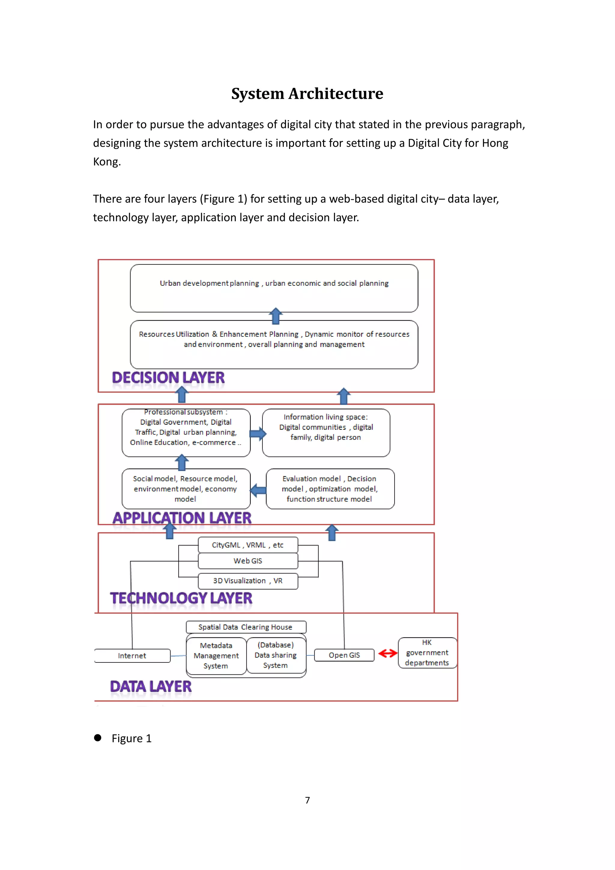
This document discusses setting up a web-based digital city for Hong Kong. It defines a digital city as an information system that collects and monitors city data to support urban decision making. The proposed system architecture has four layers: a data layer to collect and manage city data, a technology layer to build 3D models and spatial analysis tools, an application layer to implement subsystems like transportation and tourism, and a decision layer for urban planning and management. Standards for data sharing and 3D modeling are also important considerations for developing an effective web-based digital city.
Smart Cities and Big Data - Research Presentationannegalang
Research presentation on smart cities (sensor technology) and big data, presented in a graduate course I took on Transmedia Design and Digital Culture.
21c President and Founder, Dr Julia Glidden was invited by Google to be a key speaker at their TEDx event on Smart Cities. Speaking to over 200 members of Google Julia set out the concept of using a city as an innovation platform, using open data to harness the power of a cities greatest resource – its citizens.
Snap4City November 2019 Course: Smart City IOT Dashboard, smart city control ...Paolo Nesi
• Recall on Snap4City Architecture
• Dashboard Usage and Authoring
– Dashboard usage vs Widgets
– Multi Data Map Widget
– Unified Data and Services Inspection (data inspector)
– Data Inspector vs Data Processes Details
– From Data to Graphic Widgets
– GIS Data Import, Export and Exploitation
• Dashboard Creation & Exercitation
– Dashboard Creation, Exercitation
– Synoptics and Custom Widgets Creation
– Dashboards Intelligence on Web and Mobile Devices
– Dashboard ChatRoom and Notifications
• Data Type Management GDPR Compliant
– Dashboard Listing, Managing, Sharing, Delegation
– Dashboards GDPR Management
– Personal Data Management GDPR Compliant: POI, Data, KPI
• Snap4City and Km4City Projects
• Acknowledgments
INTELLIGENT REAL-TIME 3D CONFIGURATION PLATFORM FOR CUSTOMIZING E-COMMERCE PR...ijcga
In this paper is designed and realized a 3D web configurator platform able to optimize the creation of 3D objects for sale on multi e-commerce platform. The user can select online the preferred object by learning the configurator to optimize the 3D object features. A Support Vector Machine -SVM- algorithm adopting XGBoost approach, improved affect computing, user navigation experience and Visual Merchandising – VM- approach, all elements which support the creation of new object having the best effective features. The intelligent self-learning platform is designed for the real time construction of 3D CAD objects and integrates different user facilities such as augmented reality, web plugin, and WebGL graphical libraries. The proposed work follows the research and development -R&D- guidelines of ‘Frascati’ manual concerning new search engine as research topic and summarize the result of an industry research project.
Intelligent Real-time 3D Configuration Platform for Customizing E-commerce Pr...ijcga
In this paper is designed and realized a 3D web configurator platform able to optimize the creation of 3D objects for sale on multi e-commerce platform. The user can select online the preferred object by learning the configurator to optimize the 3D object features. A Support Vector Machine -SVM- algorithm adopting XGBoost approach, improved affect computing, user navigation experience and Visual Merchandising – VM- approach, all elements which support the creation of new object having the best effective features. The intelligent self-learning platform is designed for the real time construction of 3D CAD objects and integrates different user facilities such as augmented reality, web plugin, and WebGL graphical libraries. The proposed work follows the research and development -R&D- guidelines of ‘Frascati’ manual concerning new search engine as research topic and summarize the result of an industry research project.
An analytical framework for formulating metrics for evaluating multi-dimensio...Rei Takami
presented at 25th International Conference on Intelligent User Interfaces (canceled due to COVID-19)
https://dl.acm.org/doi/abs/10.1145/3377325.3377529
Abstract: This paper proposes a visual analytics framework for formulating metrics for evaluating multi-dimensional time-series data. Multidimensional time-series data has been collected and utilized in different domains. We believe evaluation metrics play an important role in utilizing those data, such as decision making and labeling training data used in machine learning. However, it is a difficult task for even domain experts to formulate metrics. To support the process of formulating metrics, the proposed framework represents metrics as a linear combination of data attributes, and provides a means for formulating it through interactive data exploration. A prototype interface that visualizes target data as an animated scatter plot was implemented. Through this interface, several visualized objects can be directly manipulated: a node and a trajectory of an instance, and a convex hull as the group of nodes and trajectories. Linear combinations of attributes are adjusted in accordance with the manipulation of different objects' types by the user. The effectiveness of the proposed framework was demonstrated through two application examples with real-world data.
WeLive project Open Government We-Government Tools Open Innovation Open Services Open Data Focus Groups Public Service Apps Bilbao Smart Cities Sustainable Participative Cities
Topic 3 - It has been argued that photorealistic 3D simulation is just pretty gimmicks with limited value. Critically review the validity of this statement.
You are instructed by Lands Department to review their web-based GeoInfo Map applications. Please critically review the strength and limitations of the technologies employed, and suggest improvements.
Significance of statistics analytics in urban making planslucyaddison1
Real Estate Business Review : It has furnished city planners with accessibility to a tremendous amount of records, which they might make use of to collect essential insights approximately the usage of municipal corporations, public transportation, and concrete dwelling patterns, assisting them assemble better infrastructure.
Applicability of big data techniques to smart cities deploymentsNexgen Technology
GET IEEE BIG DATA,JAVA ,DOTNET,ANDROID ,NS2,MATLAB,EMBEDED AT LOW COST WITH BEST QUALITY PLEASE CONTACT BELOW NUMBER
FOR MORE INFORMATION PLEASE FIND THE BELOW DETAILS:
Nexgen Technology
No :66,4th cross,Venkata nagar,
Near SBI ATM,
Puducherry.
Email Id: praveen@nexgenproject.com
Mobile: 9791938249
Telephone: 0413-2211159
www.nexgenproject.com
I gave this talk at the ITEA3 Smart City Business Event. In this talk, I introduced mago3D project, an open source based digital twin platform first. And then shared the real cases that I and my company have carried out in various industries. I concluded the talk with what I've learnt from these real projects. Some food for thoughts around digital twin were provided for further discussion.
Cloud-Based IoT Applications and Their Roles in Smart CitiesAlAtfat
A smart city is an urbanization region that collects data using several digital and physical devices. The information collected from such devices is used efficiently to manage revenues, resources, and assets, etc., while the information obtained from such devices is utilized to boost performance throughout the city. Cloud-based Internet of Things (IoT) applications could help smart cities that contain information gathered from citizens, devices, homes, and other things. This information is processed and analyzed to monitor and manage transportation networks, electric utilities, resources management, water supply systems, waste management, crime detection, security mechanisms, proficiency, digital library, healthcare facilities, and other opportunities. A cloud service provider offers public cloud services that can update the IoT environment, enabling third-party activities to embed IoT data within electronic devices executing on the IoT. In this paper, the author explored cloud-based IoT applications and their roles in smart cities.
INFRASTRUCTURE CONSOLIDATION FOR INTERCONNECTED SERVICES IN A SMART CITY USIN...csandit
Sustainability, appropriate use of natural resources and providing a better quality of life for citizens has become a prerequisite to change the traditional concept of a smart city. A smart city needs to use latest generation Information Technologies, IT, and hardware to improve services
and data, to offer to create a balanced environment between the ecosystem and inhabitants. This paper analyses the advantages of using a private cloud architecture to share hardware and software resources when it is required. Our case study is Guadalajara, which has seven municipalities and each one monitor’s air quality. Each municipality has a set of servers to process information independently and consists of information systems for the transmission and
storage of data with other municipalities. We analysed the behaviour of the carbon footprint during the years 1999-2013 and we observed a pattern in each season. Thus our proposal
requires municipalities to use a cloud-based solution that allows managing and consolidating infrastructure to minimize maintenance costs and electricity consumption to reduce carbon footprint generated by the city.
INFRASTRUCTURE CONSOLIDATION FOR INTERCONNECTED SERVICES IN A SMART CITY USIN...cscpconf
Sustainability, appropriate use of natural resources and providing a better quality of life for citizens has become a prerequisite to change the traditional concept of a smart city. A smart city needs to use latest generation Information Technologies, IT, and hardware to improve services and data, to offer to create a balanced environment between the ecosystem and inhabitants. This paper analyses the advantages of using a private cloud architecture to share hardware and software resources when it is required. Our case study is Guadalajara, which has seven municipalities and each one monitor’s air quality. Each municipality has a set of servers to process information independently and consists of information systems for the transmission and storage of data with other municipalities. We analysed the behaviour of the carbon footprint during the years 1999-2013 and we observed a pattern in each season. Thus our proposal requires municipalities to use a cloud-based solution that allows managing and consolidating infrastructure to minimize maintenance costs and electricity consumption to reduce carbon footprint generated by the city.
An introduction to the 3D digital city model data management solution CityGRID. From Met GeoInfo, this true 3D RDBMS software provides tools for creation, management and visualisation of 3D city models.
BIG IOT AND SOCIAL NETWORKING DATA FOR SMART CITIES Alg.docxjasoninnes20
BIG IOT AND SOCIAL NETWORKING DATA FOR SMART
CITIES:
Algorithmic improvements on Big Data Analysis in the context of RADICAL city
applications
Evangelos Psomakelis12,Fotis Aisopos1, Antonios Litke1, Konstantinos Tserpes21, Magdalini
Kardara1 and Pablo Martínez Campo3
1Distributed Knowledge and Media Systems Group, National Technical University of Athens, Zografou Campus, Athens,
Greece
2Informatics and Telematics Dept, Harokopio University of Athens, Greece
3Communications Engineering department, University of Cantabria, Santander, Spain
{fotais, litke, nkardara, tserpes, vpsomak}@mail.ntua.gr,[email protected]
Keywords: Internet of Things, Social Networking, Big Data Aggregation and Analysis, Smart City applications,
Sentiment Analysis, Machine Learning
Abstract: In this paper we present a SOA (Service Oriented Architecture)-based platform, enabling the retrieval and
analysis of big datasets stemming from social networking (SN) sites and Internet of Things (IoT) devices,
collected by smart city applications and socially-aware data aggregation services. A large set of city
applications in the areas of Participating Urbanism, Augmented Reality and Sound-Mapping throughout
participating cities is being applied, resulting into produced sets of millions of user-generated events and
online SN reports fed into the RADICAL platform. Moreover, we study the application of data analytics such
as sentiment analysis to the combined IoT and SN data saved into an SQL database, further investigating
algorithmic and configurations to minimize delays in dataset processing and results retrieval.
1 INTRODUCTION
Modern cities are increasingly turning towards
ICT technology for confronting pressures associated
with demographic changes, urbanization, climate
change (Romero Lankao, 2008) and globalization.
Therefore, most cities have undertaken significant
investments during the last decade in ICT
infrastructure including computers, broadband
connectivity and recently sensing infrastructures.
These infrastructures have empowered a number of
innovative services in areas such as participatory
sensing, urban logistics and ambient assisted living.
Such services have been extensively deployed in
several cities, thereby demonstrating the potential
benefits of ICT infrastructures for businesses and the
citizens themselves. During the last few years we
have also witnessed an explosion of sensor
deployments and social networking services, along
with the emergence of social networking (Conti et al.,
2011) and internet‐of‐things technologies (Perera et
al., 2013; Sundmaeker et al., 2010) Social and sensor
networks can be combined in order to offer a variety
of added‐value services for smart cities, as has
already been demonstrated by various early internet‐
of‐things applications (such as WikiCity(Calabrese et
al., 2007), CitySense(Murty et al., 2007),
GoogleLatitude(Page and Kobsa, 2010)), as ...
BIG IOT AND SOCIAL NETWORKING DATA FOR SMART CITIES Alg.docxtangyechloe
BIG IOT AND SOCIAL NETWORKING DATA FOR SMART
CITIES:
Algorithmic improvements on Big Data Analysis in the context of RADICAL city
applications
Evangelos Psomakelis12,Fotis Aisopos1, Antonios Litke1, Konstantinos Tserpes21, Magdalini
Kardara1 and Pablo Martínez Campo3
1Distributed Knowledge and Media Systems Group, National Technical University of Athens, Zografou Campus, Athens,
Greece
2Informatics and Telematics Dept, Harokopio University of Athens, Greece
3Communications Engineering department, University of Cantabria, Santander, Spain
{fotais, litke, nkardara, tserpes, vpsomak}@mail.ntua.gr,[email protected]
Keywords: Internet of Things, Social Networking, Big Data Aggregation and Analysis, Smart City applications,
Sentiment Analysis, Machine Learning
Abstract: In this paper we present a SOA (Service Oriented Architecture)-based platform, enabling the retrieval and
analysis of big datasets stemming from social networking (SN) sites and Internet of Things (IoT) devices,
collected by smart city applications and socially-aware data aggregation services. A large set of city
applications in the areas of Participating Urbanism, Augmented Reality and Sound-Mapping throughout
participating cities is being applied, resulting into produced sets of millions of user-generated events and
online SN reports fed into the RADICAL platform. Moreover, we study the application of data analytics such
as sentiment analysis to the combined IoT and SN data saved into an SQL database, further investigating
algorithmic and configurations to minimize delays in dataset processing and results retrieval.
1 INTRODUCTION
Modern cities are increasingly turning towards
ICT technology for confronting pressures associated
with demographic changes, urbanization, climate
change (Romero Lankao, 2008) and globalization.
Therefore, most cities have undertaken significant
investments during the last decade in ICT
infrastructure including computers, broadband
connectivity and recently sensing infrastructures.
These infrastructures have empowered a number of
innovative services in areas such as participatory
sensing, urban logistics and ambient assisted living.
Such services have been extensively deployed in
several cities, thereby demonstrating the potential
benefits of ICT infrastructures for businesses and the
citizens themselves. During the last few years we
have also witnessed an explosion of sensor
deployments and social networking services, along
with the emergence of social networking (Conti et al.,
2011) and internet‐of‐things technologies (Perera et
al., 2013; Sundmaeker et al., 2010) Social and sensor
networks can be combined in order to offer a variety
of added‐value services for smart cities, as has
already been demonstrated by various early internet‐
of‐things applications (such as WikiCity(Calabrese et
al., 2007), CitySense(Murty et al., 2007),
GoogleLatitude(Page and Kobsa, 2010)), as.
BIG IOT AND SOCIAL NETWORKING DATA FOR SMART CITIES Alg.docxhartrobert670
BIG IOT AND SOCIAL NETWORKING DATA FOR SMART
CITIES:
Algorithmic improvements on Big Data Analysis in the context of RADICAL city
applications
Evangelos Psomakelis12,Fotis Aisopos1, Antonios Litke1, Konstantinos Tserpes21, Magdalini
Kardara1 and Pablo Martínez Campo3
1Distributed Knowledge and Media Systems Group, National Technical University of Athens, Zografou Campus, Athens,
Greece
2Informatics and Telematics Dept, Harokopio University of Athens, Greece
3Communications Engineering department, University of Cantabria, Santander, Spain
{fotais, litke, nkardara, tserpes, vpsomak}@mail.ntua.gr,[email protected]
Keywords: Internet of Things, Social Networking, Big Data Aggregation and Analysis, Smart City applications,
Sentiment Analysis, Machine Learning
Abstract: In this paper we present a SOA (Service Oriented Architecture)-based platform, enabling the retrieval and
analysis of big datasets stemming from social networking (SN) sites and Internet of Things (IoT) devices,
collected by smart city applications and socially-aware data aggregation services. A large set of city
applications in the areas of Participating Urbanism, Augmented Reality and Sound-Mapping throughout
participating cities is being applied, resulting into produced sets of millions of user-generated events and
online SN reports fed into the RADICAL platform. Moreover, we study the application of data analytics such
as sentiment analysis to the combined IoT and SN data saved into an SQL database, further investigating
algorithmic and configurations to minimize delays in dataset processing and results retrieval.
1 INTRODUCTION
Modern cities are increasingly turning towards
ICT technology for confronting pressures associated
with demographic changes, urbanization, climate
change (Romero Lankao, 2008) and globalization.
Therefore, most cities have undertaken significant
investments during the last decade in ICT
infrastructure including computers, broadband
connectivity and recently sensing infrastructures.
These infrastructures have empowered a number of
innovative services in areas such as participatory
sensing, urban logistics and ambient assisted living.
Such services have been extensively deployed in
several cities, thereby demonstrating the potential
benefits of ICT infrastructures for businesses and the
citizens themselves. During the last few years we
have also witnessed an explosion of sensor
deployments and social networking services, along
with the emergence of social networking (Conti et al.,
2011) and internet‐of‐things technologies (Perera et
al., 2013; Sundmaeker et al., 2010) Social and sensor
networks can be combined in order to offer a variety
of added‐value services for smart cities, as has
already been demonstrated by various early internet‐
of‐things applications (such as WikiCity(Calabrese et
al., 2007), CitySense(Murty et al., 2007),
GoogleLatitude(Page and Kobsa, 2010)), as ...
14. To further enhance the transparency of the planning system and to facilitate a wider dissemination of statutory planning information to the public, a mobile version of the Town Planning Board (TPB)'s website was recently launched. As a GIT consultant, you are instructed by the TPB to review this newly launched mobile version of TPB homepage. Please critically review the strength and limitations of the technologies employed and suggest improvements in enhancing its GIT applications.
Critically review the role of three-dimensional photorealistic simulations in the public engagement exercise throughout the urban design process and suggest improvement measures
Essentials of Automations: The Art of Triggers and Actions in FMESafe Software
In this second installment of our Essentials of Automations webinar series, we’ll explore the landscape of triggers and actions, guiding you through the nuances of authoring and adapting workspaces for seamless automations. Gain an understanding of the full spectrum of triggers and actions available in FME, empowering you to enhance your workspaces for efficient automation.
We’ll kick things off by showcasing the most commonly used event-based triggers, introducing you to various automation workflows like manual triggers, schedules, directory watchers, and more. Plus, see how these elements play out in real scenarios.
Whether you’re tweaking your current setup or building from the ground up, this session will arm you with the tools and insights needed to transform your FME usage into a powerhouse of productivity. Join us to discover effective strategies that simplify complex processes, enhancing your productivity and transforming your data management practices with FME. Let’s turn complexity into clarity and make your workspaces work wonders!
GraphRAG is All You need? LLM & Knowledge GraphGuy Korland
Guy Korland, CEO and Co-founder of FalkorDB, will review two articles on the integration of language models with knowledge graphs.
1. Unifying Large Language Models and Knowledge Graphs: A Roadmap.
https://arxiv.org/abs/2306.08302
2. Microsoft Research's GraphRAG paper and a review paper on various uses of knowledge graphs:
https://www.microsoft.com/en-us/research/blog/graphrag-unlocking-llm-discovery-on-narrative-private-data/
Enchancing adoption of Open Source Libraries. A case study on Albumentations.AIVladimir Iglovikov, Ph.D.
Presented by Vladimir Iglovikov:
- https://www.linkedin.com/in/iglovikov/
- https://x.com/viglovikov
- https://www.instagram.com/ternaus/
This presentation delves into the journey of Albumentations.ai, a highly successful open-source library for data augmentation.
Created out of a necessity for superior performance in Kaggle competitions, Albumentations has grown to become a widely used tool among data scientists and machine learning practitioners.
This case study covers various aspects, including:
People: The contributors and community that have supported Albumentations.
Metrics: The success indicators such as downloads, daily active users, GitHub stars, and financial contributions.
Challenges: The hurdles in monetizing open-source projects and measuring user engagement.
Development Practices: Best practices for creating, maintaining, and scaling open-source libraries, including code hygiene, CI/CD, and fast iteration.
Community Building: Strategies for making adoption easy, iterating quickly, and fostering a vibrant, engaged community.
Marketing: Both online and offline marketing tactics, focusing on real, impactful interactions and collaborations.
Mental Health: Maintaining balance and not feeling pressured by user demands.
Key insights include the importance of automation, making the adoption process seamless, and leveraging offline interactions for marketing. The presentation also emphasizes the need for continuous small improvements and building a friendly, inclusive community that contributes to the project's growth.
Vladimir Iglovikov brings his extensive experience as a Kaggle Grandmaster, ex-Staff ML Engineer at Lyft, sharing valuable lessons and practical advice for anyone looking to enhance the adoption of their open-source projects.
Explore more about Albumentations and join the community at:
GitHub: https://github.com/albumentations-team/albumentations
Website: https://albumentations.ai/
LinkedIn: https://www.linkedin.com/company/100504475
Twitter: https://x.com/albumentations
GraphSummit Singapore | The Future of Agility: Supercharging Digital Transfor...Neo4j
Leonard Jayamohan, Partner & Generative AI Lead, Deloitte
This keynote will reveal how Deloitte leverages Neo4j’s graph power for groundbreaking digital twin solutions, achieving a staggering 100x performance boost. Discover the essential role knowledge graphs play in successful generative AI implementations. Plus, get an exclusive look at an innovative Neo4j + Generative AI solution Deloitte is developing in-house.
Encryption in Microsoft 365 - ExpertsLive Netherlands 2024Albert Hoitingh
In this session I delve into the encryption technology used in Microsoft 365 and Microsoft Purview. Including the concepts of Customer Key and Double Key Encryption.
Securing your Kubernetes cluster_ a step-by-step guide to success !KatiaHIMEUR1
Today, after several years of existence, an extremely active community and an ultra-dynamic ecosystem, Kubernetes has established itself as the de facto standard in container orchestration. Thanks to a wide range of managed services, it has never been so easy to set up a ready-to-use Kubernetes cluster.
However, this ease of use means that the subject of security in Kubernetes is often left for later, or even neglected. This exposes companies to significant risks.
In this talk, I'll show you step-by-step how to secure your Kubernetes cluster for greater peace of mind and reliability.
Epistemic Interaction - tuning interfaces to provide information for AI supportAlan Dix
Paper presented at SYNERGY workshop at AVI 2024, Genoa, Italy. 3rd June 2024
https://alandix.com/academic/papers/synergy2024-epistemic/
As machine learning integrates deeper into human-computer interactions, the concept of epistemic interaction emerges, aiming to refine these interactions to enhance system adaptability. This approach encourages minor, intentional adjustments in user behaviour to enrich the data available for system learning. This paper introduces epistemic interaction within the context of human-system communication, illustrating how deliberate interaction design can improve system understanding and adaptation. Through concrete examples, we demonstrate the potential of epistemic interaction to significantly advance human-computer interaction by leveraging intuitive human communication strategies to inform system design and functionality, offering a novel pathway for enriching user-system engagements.
Climate Impact of Software Testing at Nordic Testing DaysKari Kakkonen
My slides at Nordic Testing Days 6.6.2024
Climate impact / sustainability of software testing discussed on the talk. ICT and testing must carry their part of global responsibility to help with the climat warming. We can minimize the carbon footprint but we can also have a carbon handprint, a positive impact on the climate. Quality characteristics can be added with sustainability, and then measured continuously. Test environments can be used less, and in smaller scale and on demand. Test techniques can be used in optimizing or minimizing number of tests. Test automation can be used to speed up testing.
zkStudyClub - Reef: Fast Succinct Non-Interactive Zero-Knowledge Regex ProofsAlex Pruden
This paper presents Reef, a system for generating publicly verifiable succinct non-interactive zero-knowledge proofs that a committed document matches or does not match a regular expression. We describe applications such as proving the strength of passwords, the provenance of email despite redactions, the validity of oblivious DNS queries, and the existence of mutations in DNA. Reef supports the Perl Compatible Regular Expression syntax, including wildcards, alternation, ranges, capture groups, Kleene star, negations, and lookarounds. Reef introduces a new type of automata, Skipping Alternating Finite Automata (SAFA), that skips irrelevant parts of a document when producing proofs without undermining soundness, and instantiates SAFA with a lookup argument. Our experimental evaluation confirms that Reef can generate proofs for documents with 32M characters; the proofs are small and cheap to verify (under a second).
Paper: https://eprint.iacr.org/2023/1886
UiPath Test Automation using UiPath Test Suite series, part 6DianaGray10
Welcome to UiPath Test Automation using UiPath Test Suite series part 6. In this session, we will cover Test Automation with generative AI and Open AI.
UiPath Test Automation with generative AI and Open AI webinar offers an in-depth exploration of leveraging cutting-edge technologies for test automation within the UiPath platform. Attendees will delve into the integration of generative AI, a test automation solution, with Open AI advanced natural language processing capabilities.
Throughout the session, participants will discover how this synergy empowers testers to automate repetitive tasks, enhance testing accuracy, and expedite the software testing life cycle. Topics covered include the seamless integration process, practical use cases, and the benefits of harnessing AI-driven automation for UiPath testing initiatives. By attending this webinar, testers, and automation professionals can gain valuable insights into harnessing the power of AI to optimize their test automation workflows within the UiPath ecosystem, ultimately driving efficiency and quality in software development processes.
What will you get from this session?
1. Insights into integrating generative AI.
2. Understanding how this integration enhances test automation within the UiPath platform
3. Practical demonstrations
4. Exploration of real-world use cases illustrating the benefits of AI-driven test automation for UiPath
Topics covered:
What is generative AI
Test Automation with generative AI and Open AI.
UiPath integration with generative AI
Speaker:
Deepak Rai, Automation Practice Lead, Boundaryless Group and UiPath MVP
How to Get CNIC Information System with Paksim Ga.pptxdanishmna97
Pakdata Cf is a groundbreaking system designed to streamline and facilitate access to CNIC information. This innovative platform leverages advanced technology to provide users with efficient and secure access to their CNIC details.
The Art of the Pitch: WordPress Relationships and SalesLaura Byrne
Clients don’t know what they don’t know. What web solutions are right for them? How does WordPress come into the picture? How do you make sure you understand scope and timeline? What do you do if sometime changes?
All these questions and more will be explored as we talk about matching clients’ needs with what your agency offers without pulling teeth or pulling your hair out. Practical tips, and strategies for successful relationship building that leads to closing the deal.
A tale of scale & speed: How the US Navy is enabling software delivery from l...sonjaschweigert1
Rapid and secure feature delivery is a goal across every application team and every branch of the DoD. The Navy’s DevSecOps platform, Party Barge, has achieved:
- Reduction in onboarding time from 5 weeks to 1 day
- Improved developer experience and productivity through actionable findings and reduction of false positives
- Maintenance of superior security standards and inherent policy enforcement with Authorization to Operate (ATO)
Development teams can ship efficiently and ensure applications are cyber ready for Navy Authorizing Officials (AOs). In this webinar, Sigma Defense and Anchore will give attendees a look behind the scenes and demo secure pipeline automation and security artifacts that speed up application ATO and time to production.
We will cover:
- How to remove silos in DevSecOps
- How to build efficient development pipeline roles and component templates
- How to deliver security artifacts that matter for ATO’s (SBOMs, vulnerability reports, and policy evidence)
- How to streamline operations with automated policy checks on container images
Free Complete Python - A step towards Data Science
10549227d cybercity digitalcity
1. Department of Land Surveying and Geo-Informatics
LSGI4321 Geoinformation for Urban and Regional Studies
Individual Paper
Web-based Cybercity/Digital City is a new trend in
GIT development. Discuss and suggest the system
architecture, data standards and other relevant issues
in setting up a web-based cybercity/digital city for
Hong Kong.
1
2. Contents
Contents ......................................................................................................................... 2
Introduction ................................................................................................................... 3
Definition ....................................................................................................................... 4
Advantage of Web-based Digital City ............................................................................ 4
Limitation of Web-based Digital City ............................................................................. 5
System Architecture ....................................................................................................... 7
Data Standard .............................................................................................................. 10
Conclusion .................................................................................................................... 11
Reference ..................................................................................................................... 12
2
3. Introduction
In 1988, the former US vice president Al Gore first bought up a concept named
“Digital Earth”. The concept of Digital Earth is to represent the earth in a virtual
format, which is spatially referenced and interconnected with the world’s digital
knowledge archives.
Later, one of the concepts of “Digital City” was derived from digital earth. It
integrates different kinds of urban information and creates virtual spaces for citizens
in a particular city.
For the rises of digital city, there are lots of technologies and languages to assist for
setting up a digital city, such as VRML (Virtual Reality Modeling Language), CityGML,
AutoCAD, GIS, VR (Virtual Reality).
When the Digital City with web-based, it offers an interactive platform for integrating
and exchanging urban information, idea in an efficient way. The people can discover
more about the relationship between the environment and city development around
them.
In this paper, the general description of cybercity/digital city – the definition,
advantages of digital city using GIS are included. The system architecture and the
data standard, strength and limitations of web-based digital city are also discussed.
3
4. Definition
“Digital city is an information service system that supports city decisions by
continuous collection of city information and dynamically monitoring all possible
aspects of the city.” states Wang, L. (2001).
By using an up-to-date city model as a skeleton, with different kinds of city
information such as transportation, tourism, communication etc., are to support to
form a web-based digital city.
To make a digital city operate on the internet, it needs multi-disciplinary supports.
Different kinds of technologies, such as high-speed network, high-resolution earth
observation technology, GIS, GPS, and Virtual Reality (VR) etc can work together to
build a digital city.
Advantage of Web-based Digital City
Digital City has several advantages compared with the old format of integrating and
exchanging urban information. The advantages of Digital City can be classified into
four categories:
Easier to collect data
The digital city network with the GIS technologies makes the process of collecting,
releasing, and interoperating data in an efficient way. With the use of Internet, digital
city technologies can build up the data sharing system and technological platform for
urban sustainable development.
Effective for integration
An urban database should be built before setting up a digital city, it store the
reproduction of real city in virtual way. The database can effective integrate lots of
urban subsystems such as population, resources, transport, environment etc.
Moreover, the integrated database of digital city can allocate and utilize different
kinds of urban resources in space and time effectively. The useful decisions of urban
development can also be made with the aid of digital city.
4
5. Interactive experience
Users can have a more interactive way for discovering things of the city through
Web-based Digital City. Internet always makes the Digital City can offer a great
interactive experience for the users. Numbers of virtual modeling created a Digital
City, this offer an interactive experience for the users to explore the space and area,
and interact with the interested content as they like.
Great visualization capabilities
The models appear in the digital city are in 3D format, so 3D visualization is a key
technology that using in digital city. 3D visualization and VR enhances the efficiency
not only city planning, but also public participating. This statement is supported by
North and Macal (2007), “Visualization is one of the most effective ways to present
key model information to decision-makers.” City planners can plan the city with use
of the virtual perception. Also, the public can have the same planning experience
through web-based digital city. Since there are numbers of technologies such as CAD
technologies, CityGML, 3dmax etc., can assist the professional for 3D modeling, the
quality of the models are very high.
Limitation of Web-based Digital City
Since there are two sides to every coin, there are some limitations for nowadays
technology development of Digital City. The limitations would be listed as follows:
Underdeveloped analytical functions of 3D city models
There is a truth that analytical functionality of 3D city models is always
underdeveloped (Batty and Hudson-Smith, 2002).Furthermore, those models have
only little spatial analysis. Although the models often exist with different types of
data sets, but they are only as empty shells, there are no analysis capabilities itself.
Data gathering
Nowadays, many types of data for digital city can be achieved from different kinds of
sources , for examples, from different government departments, surveying works,
remote sensing, but some problems have been rise – how to gather and manage
large amount of data which is achieved from different sources?
5
6. An integrated multi-platform data system should be built to monitor and simulate
Low speed of generating 3D models
The speed of generating 3D models is relatively low. Also, the methods of generating
3D models are immature. Nowadays, “the development of a more automated
pipeline for 3D city modeling from satellite, aerial and terrestrial imagery and/or
LiDAR point-clouds is a challenge” states Wu (2011).
Difficult to model internal structures of buildings
Although it is easier to model the external structures of the building with the aid of
different types of technologies and resources, while, the internal structures of the
buildings are still comparatively difficult to model. The internal structures of the
buildings are very complex, such as multi-floor buildings have over several floors
with interconnecting stairways, mixed land use. It is difficult to present the complex
internal structures for the users to have an analysis inside the buildings.
6
7. System Architecture
In order to pursue the advantages of digital city that stated in the previous paragraph,
designing the system architecture is important for setting up a Digital City for Hong
Kong.
There are four layers (Figure 1) for setting up a web-based digital city– data layer,
technology layer, application layer and decision layer.
Figure 1
7
8. Data Layer
Data collection and data management can be implemented on this layer. Firstly, a
data sharing system should be built on the server side. Different departments of the
Hong Kong government can transfer their own data of the city into this database. For
example, Census and Statistics Department can offer the population data with
different years. Transport Department can provide the transport network of Hong
Kong into this database, and the information of the traffic condition on the major
roads. Planning Department can give out the latest city planning project information
into this database.
Due to the large amount of data, spatial data clearing house and the metadata
management system are for making all data accurate and useful. Those systems can
manage the data in a correct format.
Technology layer
This layer implements the basic and abstracted functions on data layer. Technological
components such as Remote Sensing, GIS, the Internet, VR and 3D interaction are
running as important part of the integration. Though this layer, the whole Hong Kong
can be seen as 3D format. With use of Web-GIS, the users can get the spatial data of
Hong Kong in digital city. For example, the users can get the coordinates of the
particular point on Hong Kong, the distance between two sites, the area of the
particular sites.
Application layer
After the 3D models have been built in digital city, this layer can implement different
types of sub-systems on the digital platform. Each sub-system included different
functions. These sub-systems can help the professional to manage and operate the
whole city. For example, the users can view the population data in the districts unit
of Hong Kong or in building unit through 3D models. The users can get a conceptual,
virtual perception of the latest urban planning project by web-based digital city. Also,
the users can know the traffic condition of main roads in Hong Kong. The whole Hong
Kong will be presented in digital city by visualization format.
Decision Support layer
Dynamic supervision, simulation, monitoring on this layer can assist the professional
8
9. to make a decision for urban development. Moreover, this provides services to the
scientific decision and management of urban development. Also, the public can
involve in this decision layer too. The users can have a virtual urban planning on this
layer. It will visualize the possible results and outcomes of the proposed planning
decision.
9
10. Data Standard
Data types
Due to the visualization of the real whole city, large amount of data should be
involved in the system of Digital City for Hong Kong. They are, but not limited to:
Digital Terrain Models (DTM, DSM), Building Models (2D & 3D), Raster data (Aerial
Images, Textures, and Oblique View etc.), architectural models, Linder, Vegetation
models, Topology, Infrastructure, and Cadastral Data.
For higher-resolution DTM data, is used as the main part of the 3D city models.
Digital terrain model is needed to build terrain of the digital city. Building footprints,
building textures are also needed for building 3D models.
Cadastral Data is used for offering the official footprints of buildings, land parcels,
ownership and address information into the database of digital city.
For raster data such as aerial images, oblique view can be acquired by Remote
Sensing technology. Lately, the advanced remote sensing technology, and data
processing can provide a high quality of automated capturing and processing of
geodata, for example, the data of detailed building geometry - roofs, vegetation etc.
For LiDAR, the users can calculate the height statistic for each building by GIS
technology. These statistics typically include average, maximum and minimum
heights. Also, we can have the building polygon based since the LiDAR points fall
within the polygon. Building polygons can be extruded to a set height (for example
average height of LiDAR points locating within that building polygon footprint) for
visualization purposes is the result. (Batty et al, 2007)
Last but not least, topology expresses different types of spatial relationships as lists
of features. The ability to create and store topological relationships has a number of
advantages.
Geometrical elements of 3D city models
According to the geometrical elements of 3D city models, the 3D data can be
categorized by different hierarchy and complexity. (Zhu, 2009)
(1) 2D digital orthoimage map (DOM)
10
11. the texture of terrain surface, multiresolution DOMs from high resolution satellite
imagery to aerial imagery offers the details of real and provides a time stamped
record of land use, urban development and the general environment;
(2) 2.5D DEM, a digital representation of ground surface topography or terrain, is the
most common foundation of 3D city models;
(3) 2.5D linear elements, the centerlines and boundaries of road, rivers, railways and
landuse, showing the outline of an object;
(4) 3D solid objects, external and/or internal surfaces of buildings, bridges overpasses,
pipelines, stratum, etc., showing the entire volume of an object.
Conclusion
It is undoubtedly that Web-based Digital City will become a trend for the
future of GIT development. Since Web-based Digital City is a good platform for not
only visualizing the whole city in 3D format, presenting and exchanging the urban
data in an efficient way, but also assisting the urban planners for making decisions for
the future planning. This is a new trend for the professional, scientists, urban planner,
business man etc. to have a multi-angle views to discover how the environment
changes in the city, to analysis the urban information through 3D models. Moreover,
this technology offer a chance for the public to participate for the future urban
planning. Certainly, web-based Digital City will have a great impact for the future
development of a city.
For designing system architecture of the digital city, four layers – data layer,
technology layer, application layer, decision layer –should be considered in order to
optimize the interaction of the whole system. And also, the data standards are
needed to be considered before setting up a digital city.
To conclude, for the development of technology today, there are lots of strengths for
setting up digital city. Many technologies such as CAD technologies, CityGML, 3dmax,
GPU etc, can assist the technicians for building a digital city, while some limitations
still exists in the nowadays technology. In order to optimize the utilization of Digital
City, the GIT professionals need to find out the solutions to break through the
bottleneck for the 3D technologies today.
11
12. Reference
Batty, M. and Hudson-Smith, A. (2002), 'Virtuality and Cities: Definitions,
Geographies, Designs', in Fisher, P. and Unwin, D. (eds.), Virtual Reality in Geography,
Taylor & Francis, London, UK, pp. 270-291.
Batty, M, Carvalho, R., Hudson-Smith, A., Milton, R., Smith, D., Steadman, P.,
(2007), “Scaling and Allometry in the Building Geometries of Greater London”. CASA
working paper 126 (http://www.casa.ucl.ac.uk/working_papers/paper126.pdf)
North, M.J. and Macal, C.M. (2007), Managing Business Complexity: Discovering
Strategic Solutions with Agent-Based Modelling and Simulation, Oxford University
Press, New York, NY.
Wang, L., Wu, H. Y. & Song, H. (2009). A Framework of Integrating Digital City and
Eco-city. Retrieved October 18, 2011 from
http://www0.hku.hk/dupad/asiagis/fall03/Full_Paper/Wang_Lu.pdf
Wu, B. (2011). From Static to Dynamic Virtual Urban Environment: Challenges and
Considerations. ICA2011 Workshop on Persistent Problems in Geographic
Visualization, .
Zhu, Q., Hu, M. Y. & Zhang, Y. T. (2009). Research and Practice in Three-Dimensional
City Modeling. Retrieved October 18, 2011 from
http://www.springerlink.com/content/y75rg377t61r6l70/
12