SlideShare a Scribd company logo
1 of 29
Remote Sensing
What is Remote Sensing ? ?
?
Remote sensing
means collecting data
from remote location
without coming in
contact with the
object.
WE CAN SAY…..
Same Like……!!!
Three Sides Of Remote
Sensing
Basic concept of Remote
sensing
Digital Image Processing
Global Positioning System
Principle of Remote
sensing
Mapping the earth surface features
by reflected electromagnetic energy
which is different for different object is
measured by sensors on remote
platform (satellite).
Various Components
 The Energy Source
 Interaction of Energy with
Atmosphere
 Interaction of Energy with Target
 Recording of Energy by Sensor
 Transmission, Reception and
Processing
 Interpretation and Analysis
 Application
Electromagnetic Spectrum
 The light which our eyes are able
to see is comprised of seven
colors which which is only a very
small portion of EM spectrum
coming from the sun to earth’s
surface
 Energy coming fro the sun
comprises energy wave length
varying from 1/1000000 μm to
Energy Interaction with
Objects
 EM energy when comes in a contact
with objects, some energy is absorbed
by the object and some energy is
transmitted through the object.
 Energy Incident = Energy absorbed +
Energy Transmitted +
Energy Reflected
EI = EA + ET + ER
Energy Interaction With Atmosphere
 Reflected EM energy from the surface
object passes through the atmosphere
and reach through the satellite
 During transmission of waves some
energy absorbed by gases and water
vapor.
 Absorption and scattering of energy
for certain selected waves only thus
recording of EM energy by sensors is
distributed in that particular length.
Energy Interaction with Earth
Surface Features
Here are some spectral response of
main features of earth.
• Vegetation
• Soil
• Water
• Snow and Cloud
Remote Sensing Platforms
I. Balloons
II. Aeroplanes
III. Helicopters
IV. Satellites
V. Spacecraft
VI. Probes
VII. Rovers
VIII.Launch vehicles
Move in atmosphere
Perspective Photo
with large error
Un-economical
Move in space of zero
gravity
Orthographic Images less
errors
Repetitive supply of
images
Initial
Cost is more but looking to
volume of images it is
economical
Types Of Remote
Sensing
Passive Remote
Sensing
Active Remote
 Passive Remote Sensing :
In remote sensing sun’s
electromagnetic energy which is
reflected by different object is received
by sensors on satellite to create images
is known as passive remote sensing.
 Active Remote Sensing :
Active remote sensing makes use of
sensors that detect reflect responses
from objects that are irradiating from
artificial generated energy sources, such
as radar.
Types Of Images
 Panchromatic Remote Sensing
Images
 Multispectral Remote Sensing
Images
 Hyper spectral Remote Sensing
Images
 Digital Images
Digital Images Processing
It means manipulating digital
number of pixel for better viewing
of image or scene. Digital Image
process are as follows:
 Radiometric and geometric correction
 Image and enhancement
 Band Combination
Global
Positioning
System
(GPS)
Functions Of GPS
 To provide coordinates like
Latitude
Longitude
Elevation above mean sea level and
time
 The Global positioning system is
worldwide radio navigation system
formed from a constellation of 24
satellites and their ground stations.
 GPS use this “artificial stars” as a
reference point to calculate positions
accurately.
Segments Of GPS
 Satellite constellation called
space segment.
The satellite constellation contains
the satellites in orbit that provide the
ranging signals and data messages to
the user equipment.
 Ground control / Monitoring
network called operational
control segment.
The OCS tracks and maintains the
satellite in space. It also updates
satellite clock corrections and
ephemeris as well as well as other
parameters essential for the
determinations of user position
velocity and time.
 User receiving equipment
called user equipment
segment.
The equipment segment performs
the navigation, timing or other related
functions.
Uses and
ApplicationsSome of the uses and
application, global, regional and
local are as follows:
• Navigation
• Surveying
Navigation
 Marine
 Air navigation
Surveying
GPS is useful to survey various data
as follows:
• Local property survey
• Site survey
• Topographical survey
• Kinematic survey
• Geodetic survey
• Contour survey
INDIA & GPS
 India has launched “मंगलयान” or “Mars
Orbiter Mission”
The mission is a "technology
demonstrator" project to develop the
technologies for designing, planning,
management, and operations of an
interplanetary mission. It carries five
instruments that will help advance
knowledge about Mars to achieve its
secondary, scientific objective. The
spacecraft is currently being monitored
Yes, Ittu sa step &
INDIA will independent
in GPS
ISRO is going to put one last
satellite in IRNSS category to
independent for GPS system.
We are just one single step
behind to be in queue of nations
like America, Russia, China,
France etc, who has separate
GPS system.
International Star ISRO
 From 2013 to 2015 ISRO has launched
two for Australia, five for Canada, one
for Denmark Germany & Indonesia,
seven for Singapore, six for UK, in total
almost 28 satellite and got income of
almost 86 million dollar.
Thank u…!!!

More Related Content

What's hot

Basic of Remote Sensing
Basic of Remote SensingBasic of Remote Sensing
Basic of Remote Sensinggueste5cfed
 
Introduction to aerial photography and photogrammetry.ppt
Introduction to aerial photography and photogrammetry.pptIntroduction to aerial photography and photogrammetry.ppt
Introduction to aerial photography and photogrammetry.pptsrinivas2036
 
remote sensing
remote sensingremote sensing
remote sensing78harshith
 
Intro to GIS and Remote Sensing
Intro to GIS and Remote SensingIntro to GIS and Remote Sensing
Intro to GIS and Remote SensingJohn Reiser
 
Remote sensing and image interpretation
Remote sensing and image interpretationRemote sensing and image interpretation
Remote sensing and image interpretationMd. Nazir Hossain
 
Introduction and Application of GIS
Introduction and Application of GISIntroduction and Application of GIS
Introduction and Application of GISSatish Taji
 
Thermal remote sensing
Thermal remote sensing   Thermal remote sensing
Thermal remote sensing Rahat Malik
 
Remote Sensing PPT
Remote Sensing PPTRemote Sensing PPT
Remote Sensing PPTAmal Murali
 
Remote sensing-presentaion
Remote sensing-presentaionRemote sensing-presentaion
Remote sensing-presentaionMouna Guru
 
side-looking airborne radar
side-looking airborne radarside-looking airborne radar
side-looking airborne radarSneha Nalla
 
Ppt on remote sensing system
Ppt on remote sensing systemPpt on remote sensing system
Ppt on remote sensing systemAlisha Korpal
 
Geographic information system (gis)
Geographic information system (gis)Geographic information system (gis)
Geographic information system (gis)Vandana Verma
 
Basic Concepts of Remote Sensing
Basic Concepts of Remote Sensing Basic Concepts of Remote Sensing
Basic Concepts of Remote Sensing Somenath Goswami
 
REMOTE SENSING A VERY USEFUL TECHNOLOGY TO MANKIND
REMOTE SENSING A VERY USEFUL TECHNOLOGY TO MANKINDREMOTE SENSING A VERY USEFUL TECHNOLOGY TO MANKIND
REMOTE SENSING A VERY USEFUL TECHNOLOGY TO MANKINDkaushikakumar
 
Chapter 3: Remote sensing Technology
Chapter 3: Remote sensing TechnologyChapter 3: Remote sensing Technology
Chapter 3: Remote sensing TechnologyShankar Gangaju
 

What's hot (20)

remote sensing
remote sensingremote sensing
remote sensing
 
Basic of Remote Sensing
Basic of Remote SensingBasic of Remote Sensing
Basic of Remote Sensing
 
Introduction to aerial photography and photogrammetry.ppt
Introduction to aerial photography and photogrammetry.pptIntroduction to aerial photography and photogrammetry.ppt
Introduction to aerial photography and photogrammetry.ppt
 
remote sensing
remote sensingremote sensing
remote sensing
 
Remote sensing
Remote sensingRemote sensing
Remote sensing
 
Intro to GIS and Remote Sensing
Intro to GIS and Remote SensingIntro to GIS and Remote Sensing
Intro to GIS and Remote Sensing
 
Remote sensing and image interpretation
Remote sensing and image interpretationRemote sensing and image interpretation
Remote sensing and image interpretation
 
Introduction and Application of GIS
Introduction and Application of GISIntroduction and Application of GIS
Introduction and Application of GIS
 
Thermal remote sensing
Thermal remote sensing   Thermal remote sensing
Thermal remote sensing
 
Remote Sensing PPT
Remote Sensing PPTRemote Sensing PPT
Remote Sensing PPT
 
Remote sensing
Remote sensingRemote sensing
Remote sensing
 
Remote sensing-presentaion
Remote sensing-presentaionRemote sensing-presentaion
Remote sensing-presentaion
 
Remote sensing
Remote sensing   Remote sensing
Remote sensing
 
side-looking airborne radar
side-looking airborne radarside-looking airborne radar
side-looking airborne radar
 
Ppt on remote sensing system
Ppt on remote sensing systemPpt on remote sensing system
Ppt on remote sensing system
 
Geographic information system (gis)
Geographic information system (gis)Geographic information system (gis)
Geographic information system (gis)
 
Basic Concepts of Remote Sensing
Basic Concepts of Remote Sensing Basic Concepts of Remote Sensing
Basic Concepts of Remote Sensing
 
Functions of GIS
Functions of GISFunctions of GIS
Functions of GIS
 
REMOTE SENSING A VERY USEFUL TECHNOLOGY TO MANKIND
REMOTE SENSING A VERY USEFUL TECHNOLOGY TO MANKINDREMOTE SENSING A VERY USEFUL TECHNOLOGY TO MANKIND
REMOTE SENSING A VERY USEFUL TECHNOLOGY TO MANKIND
 
Chapter 3: Remote sensing Technology
Chapter 3: Remote sensing TechnologyChapter 3: Remote sensing Technology
Chapter 3: Remote sensing Technology
 

Viewers also liked

Remote sensing ppt
Remote sensing pptRemote sensing ppt
Remote sensing pptcoolmridul92
 
Gps and remote sensing
Gps and remote sensingGps and remote sensing
Gps and remote sensingSanila Khalid
 
Uncertainty Analysis and Data Assimilation of Remote Sensing Data for the Cal...
Uncertainty Analysis and Data Assimilation of Remote Sensing Data for the Cal...Uncertainty Analysis and Data Assimilation of Remote Sensing Data for the Cal...
Uncertainty Analysis and Data Assimilation of Remote Sensing Data for the Cal...Hans van der Kwast
 
Mangalyaan - India's First Interplanetary Mission to Mars
Mangalyaan - India's First Interplanetary Mission to MarsMangalyaan - India's First Interplanetary Mission to Mars
Mangalyaan - India's First Interplanetary Mission to MarsAerospaceinindia.org
 
Planimeter - GPS Area Measure. Description, Features and Applications.
Planimeter - GPS Area Measure. Description, Features and Applications.Planimeter - GPS Area Measure. Description, Features and Applications.
Planimeter - GPS Area Measure. Description, Features and Applications.VisTech.Projects
 
FIELD ASTRONOMY SURVEYING
FIELD ASTRONOMY SURVEYINGFIELD ASTRONOMY SURVEYING
FIELD ASTRONOMY SURVEYINGKavin Raval
 
Hydrographic Surveying By Jithin Jose
Hydrographic Surveying  By Jithin JoseHydrographic Surveying  By Jithin Jose
Hydrographic Surveying By Jithin JoseJithin Jose
 
Basic astronomy
Basic astronomy Basic astronomy
Basic astronomy MPerezBaena
 
History Of Astronomy (Complete)
History Of Astronomy (Complete)History Of Astronomy (Complete)
History Of Astronomy (Complete)Oyster River HS
 

Viewers also liked (20)

Remote sensing ppt
Remote sensing pptRemote sensing ppt
Remote sensing ppt
 
Flyover bridge
Flyover bridgeFlyover bridge
Flyover bridge
 
Gps and remote sensing
Gps and remote sensingGps and remote sensing
Gps and remote sensing
 
Uncertainty Analysis and Data Assimilation of Remote Sensing Data for the Cal...
Uncertainty Analysis and Data Assimilation of Remote Sensing Data for the Cal...Uncertainty Analysis and Data Assimilation of Remote Sensing Data for the Cal...
Uncertainty Analysis and Data Assimilation of Remote Sensing Data for the Cal...
 
Mangalyaan - India's First Interplanetary Mission to Mars
Mangalyaan - India's First Interplanetary Mission to MarsMangalyaan - India's First Interplanetary Mission to Mars
Mangalyaan - India's First Interplanetary Mission to Mars
 
Modern Survey Techniques
Modern Survey TechniquesModern Survey Techniques
Modern Survey Techniques
 
Route Surveys
Route SurveysRoute Surveys
Route Surveys
 
Planimeter - GPS Area Measure. Description, Features and Applications.
Planimeter - GPS Area Measure. Description, Features and Applications.Planimeter - GPS Area Measure. Description, Features and Applications.
Planimeter - GPS Area Measure. Description, Features and Applications.
 
GPS application soil survey
GPS application soil surveyGPS application soil survey
GPS application soil survey
 
Route Survey
Route SurveyRoute Survey
Route Survey
 
Remote sensing
Remote sensingRemote sensing
Remote sensing
 
Astronomical surveying
Astronomical surveyingAstronomical surveying
Astronomical surveying
 
FIELD ASTRONOMY SURVEYING
FIELD ASTRONOMY SURVEYINGFIELD ASTRONOMY SURVEYING
FIELD ASTRONOMY SURVEYING
 
Remote Sensing of Aerosols
Remote Sensing of AerosolsRemote Sensing of Aerosols
Remote Sensing of Aerosols
 
Hydrographic Surveying By Jithin Jose
Hydrographic Surveying  By Jithin JoseHydrographic Surveying  By Jithin Jose
Hydrographic Surveying By Jithin Jose
 
Remote Sensing
Remote SensingRemote Sensing
Remote Sensing
 
flyover and bridge problems and its solutions
flyover and bridge problems and its solutionsflyover and bridge problems and its solutions
flyover and bridge problems and its solutions
 
Basic astronomy
Basic astronomy Basic astronomy
Basic astronomy
 
MANGALYAAN
MANGALYAANMANGALYAAN
MANGALYAAN
 
History Of Astronomy (Complete)
History Of Astronomy (Complete)History Of Astronomy (Complete)
History Of Astronomy (Complete)
 

Similar to Remote sensing

remote sensing for study.docx
remote sensing for study.docxremote sensing for study.docx
remote sensing for study.docxbbc37142
 
APPLICATION OF REMOTE SENSING AND GIS IN AGRICULTURE
APPLICATION OF REMOTE SENSING AND GIS IN AGRICULTUREAPPLICATION OF REMOTE SENSING AND GIS IN AGRICULTURE
APPLICATION OF REMOTE SENSING AND GIS IN AGRICULTURELagnajeetRoy
 
A Brief Introduction to Remote Sensing Satellites
A Brief Introduction to Remote Sensing Satellites A Brief Introduction to Remote Sensing Satellites
A Brief Introduction to Remote Sensing Satellites Alireza Rahimzadeganasl
 
remote sensing ppt.pptx
remote sensing ppt.pptxremote sensing ppt.pptx
remote sensing ppt.pptxswarnrajsingh1
 
Remote Sensing and its Applications in Agriculture
Remote Sensing and its Applications in AgricultureRemote Sensing and its Applications in Agriculture
Remote Sensing and its Applications in AgricultureVikas Kashyap
 
Fundamental of Remote Sensing.pptx
Fundamental of Remote Sensing.pptxFundamental of Remote Sensing.pptx
Fundamental of Remote Sensing.pptxSonalGosai2
 
Fundamental of Remote Sensing.pptx
Fundamental of Remote Sensing.pptxFundamental of Remote Sensing.pptx
Fundamental of Remote Sensing.pptxSonalGosai2
 
Remote Sensing: Meaning, Concept and Components | Geography
Remote Sensing: Meaning, Concept and Components | GeographyRemote Sensing: Meaning, Concept and Components | Geography
Remote Sensing: Meaning, Concept and Components | GeographySrimantaKarak
 
rsgis-unitii-160731062950.pdf
rsgis-unitii-160731062950.pdfrsgis-unitii-160731062950.pdf
rsgis-unitii-160731062950.pdfBSuresh26
 
Types of Remote Sensing.pdf
Types of Remote Sensing.pdfTypes of Remote Sensing.pdf
Types of Remote Sensing.pdfUjjwalSubedi8
 
Chapter 1 (Introduction to remote sensing)
Chapter 1 (Introduction to remote sensing)Chapter 1 (Introduction to remote sensing)
Chapter 1 (Introduction to remote sensing)Shankar Gangaju
 

Similar to Remote sensing (20)

remote sensing for study.docx
remote sensing for study.docxremote sensing for study.docx
remote sensing for study.docx
 
Ch 5 b remote sensing
Ch 5 b remote sensingCh 5 b remote sensing
Ch 5 b remote sensing
 
APPLICATION OF REMOTE SENSING AND GIS IN AGRICULTURE
APPLICATION OF REMOTE SENSING AND GIS IN AGRICULTUREAPPLICATION OF REMOTE SENSING AND GIS IN AGRICULTURE
APPLICATION OF REMOTE SENSING AND GIS IN AGRICULTURE
 
A Brief Introduction to Remote Sensing Satellites
A Brief Introduction to Remote Sensing Satellites A Brief Introduction to Remote Sensing Satellites
A Brief Introduction to Remote Sensing Satellites
 
remote sensing ppt.pptx
remote sensing ppt.pptxremote sensing ppt.pptx
remote sensing ppt.pptx
 
Remote sensing
Remote sensingRemote sensing
Remote sensing
 
Remote sensing
Remote sensingRemote sensing
Remote sensing
 
Remote Sensing and its Applications in Agriculture
Remote Sensing and its Applications in AgricultureRemote Sensing and its Applications in Agriculture
Remote Sensing and its Applications in Agriculture
 
Fundamental of Remote Sensing.pptx
Fundamental of Remote Sensing.pptxFundamental of Remote Sensing.pptx
Fundamental of Remote Sensing.pptx
 
Fundamental of Remote Sensing.pptx
Fundamental of Remote Sensing.pptxFundamental of Remote Sensing.pptx
Fundamental of Remote Sensing.pptx
 
Remote Sensing: Meaning, Concept and Components | Geography
Remote Sensing: Meaning, Concept and Components | GeographyRemote Sensing: Meaning, Concept and Components | Geography
Remote Sensing: Meaning, Concept and Components | Geography
 
Report
ReportReport
Report
 
rsgis-unitii-160731062950.pdf
rsgis-unitii-160731062950.pdfrsgis-unitii-160731062950.pdf
rsgis-unitii-160731062950.pdf
 
Types of Remote Sensing.pdf
Types of Remote Sensing.pdfTypes of Remote Sensing.pdf
Types of Remote Sensing.pdf
 
Introduction to Remote Sensing
Introduction to Remote SensingIntroduction to Remote Sensing
Introduction to Remote Sensing
 
Remote sensing 1
Remote sensing 1Remote sensing 1
Remote sensing 1
 
Chapter 1 (Introduction to remote sensing)
Chapter 1 (Introduction to remote sensing)Chapter 1 (Introduction to remote sensing)
Chapter 1 (Introduction to remote sensing)
 
REMOTE SENSING
REMOTE SENSINGREMOTE SENSING
REMOTE SENSING
 
2014_Remote Sensing.pptx
2014_Remote Sensing.pptx2014_Remote Sensing.pptx
2014_Remote Sensing.pptx
 
RS_GIS_GPS.pdf
RS_GIS_GPS.pdfRS_GIS_GPS.pdf
RS_GIS_GPS.pdf
 

More from Practicing In Some Infra Company (10)

Thermal Insulation Understanding and Techniques
Thermal Insulation Understanding and TechniquesThermal Insulation Understanding and Techniques
Thermal Insulation Understanding and Techniques
 
Slums
SlumsSlums
Slums
 
Types of wires and cables
Types of wires and cablesTypes of wires and cables
Types of wires and cables
 
Types of excavating tools and machine
Types of excavating tools and machineTypes of excavating tools and machine
Types of excavating tools and machine
 
Electrical wiring
Electrical wiringElectrical wiring
Electrical wiring
 
Electrical Wiring Practices and Diagrams
Electrical Wiring Practices and DiagramsElectrical Wiring Practices and Diagrams
Electrical Wiring Practices and Diagrams
 
Flood
FloodFlood
Flood
 
Water softing by reverse osmosis method
Water softing by reverse osmosis methodWater softing by reverse osmosis method
Water softing by reverse osmosis method
 
Engineering graphics
Engineering graphicsEngineering graphics
Engineering graphics
 
Contributor personality development
Contributor personality developmentContributor personality development
Contributor personality development
 

Recently uploaded

VICTOR MAESTRE RAMIREZ - Planetary Defender on NASA's Double Asteroid Redirec...
VICTOR MAESTRE RAMIREZ - Planetary Defender on NASA's Double Asteroid Redirec...VICTOR MAESTRE RAMIREZ - Planetary Defender on NASA's Double Asteroid Redirec...
VICTOR MAESTRE RAMIREZ - Planetary Defender on NASA's Double Asteroid Redirec...VICTOR MAESTRE RAMIREZ
 
Risk Assessment For Installation of Drainage Pipes.pdf
Risk Assessment For Installation of Drainage Pipes.pdfRisk Assessment For Installation of Drainage Pipes.pdf
Risk Assessment For Installation of Drainage Pipes.pdfROCENODodongVILLACER
 
Electronically Controlled suspensions system .pdf
Electronically Controlled suspensions system .pdfElectronically Controlled suspensions system .pdf
Electronically Controlled suspensions system .pdfme23b1001
 
Introduction to Machine Learning Unit-3 for II MECH
Introduction to Machine Learning Unit-3 for II MECHIntroduction to Machine Learning Unit-3 for II MECH
Introduction to Machine Learning Unit-3 for II MECHC Sai Kiran
 
complete construction, environmental and economics information of biomass com...
complete construction, environmental and economics information of biomass com...complete construction, environmental and economics information of biomass com...
complete construction, environmental and economics information of biomass com...asadnawaz62
 
Artificial-Intelligence-in-Electronics (K).pptx
Artificial-Intelligence-in-Electronics (K).pptxArtificial-Intelligence-in-Electronics (K).pptx
Artificial-Intelligence-in-Electronics (K).pptxbritheesh05
 
GDSC ASEB Gen AI study jams presentation
GDSC ASEB Gen AI study jams presentationGDSC ASEB Gen AI study jams presentation
GDSC ASEB Gen AI study jams presentationGDSCAESB
 
Sachpazis Costas: Geotechnical Engineering: A student's Perspective Introduction
Sachpazis Costas: Geotechnical Engineering: A student's Perspective IntroductionSachpazis Costas: Geotechnical Engineering: A student's Perspective Introduction
Sachpazis Costas: Geotechnical Engineering: A student's Perspective IntroductionDr.Costas Sachpazis
 
Heart Disease Prediction using machine learning.pptx
Heart Disease Prediction using machine learning.pptxHeart Disease Prediction using machine learning.pptx
Heart Disease Prediction using machine learning.pptxPoojaBan
 
EduAI - E learning Platform integrated with AI
EduAI - E learning Platform integrated with AIEduAI - E learning Platform integrated with AI
EduAI - E learning Platform integrated with AIkoyaldeepu123
 
An experimental study in using natural admixture as an alternative for chemic...
An experimental study in using natural admixture as an alternative for chemic...An experimental study in using natural admixture as an alternative for chemic...
An experimental study in using natural admixture as an alternative for chemic...Chandu841456
 
Oxy acetylene welding presentation note.
Oxy acetylene welding presentation note.Oxy acetylene welding presentation note.
Oxy acetylene welding presentation note.eptoze12
 
CCS355 Neural Networks & Deep Learning Unit 1 PDF notes with Question bank .pdf
CCS355 Neural Networks & Deep Learning Unit 1 PDF notes with Question bank .pdfCCS355 Neural Networks & Deep Learning Unit 1 PDF notes with Question bank .pdf
CCS355 Neural Networks & Deep Learning Unit 1 PDF notes with Question bank .pdfAsst.prof M.Gokilavani
 
IVE Industry Focused Event - Defence Sector 2024
IVE Industry Focused Event - Defence Sector 2024IVE Industry Focused Event - Defence Sector 2024
IVE Industry Focused Event - Defence Sector 2024Mark Billinghurst
 
CCS355 Neural Network & Deep Learning UNIT III notes and Question bank .pdf
CCS355 Neural Network & Deep Learning UNIT III notes and Question bank .pdfCCS355 Neural Network & Deep Learning UNIT III notes and Question bank .pdf
CCS355 Neural Network & Deep Learning UNIT III notes and Question bank .pdfAsst.prof M.Gokilavani
 
What are the advantages and disadvantages of membrane structures.pptx
What are the advantages and disadvantages of membrane structures.pptxWhat are the advantages and disadvantages of membrane structures.pptx
What are the advantages and disadvantages of membrane structures.pptxwendy cai
 
Application of Residue Theorem to evaluate real integrations.pptx
Application of Residue Theorem to evaluate real integrations.pptxApplication of Residue Theorem to evaluate real integrations.pptx
Application of Residue Theorem to evaluate real integrations.pptx959SahilShah
 
INFLUENCE OF NANOSILICA ON THE PROPERTIES OF CONCRETE
INFLUENCE OF NANOSILICA ON THE PROPERTIES OF CONCRETEINFLUENCE OF NANOSILICA ON THE PROPERTIES OF CONCRETE
INFLUENCE OF NANOSILICA ON THE PROPERTIES OF CONCRETEroselinkalist12
 

Recently uploaded (20)

Design and analysis of solar grass cutter.pdf
Design and analysis of solar grass cutter.pdfDesign and analysis of solar grass cutter.pdf
Design and analysis of solar grass cutter.pdf
 
VICTOR MAESTRE RAMIREZ - Planetary Defender on NASA's Double Asteroid Redirec...
VICTOR MAESTRE RAMIREZ - Planetary Defender on NASA's Double Asteroid Redirec...VICTOR MAESTRE RAMIREZ - Planetary Defender on NASA's Double Asteroid Redirec...
VICTOR MAESTRE RAMIREZ - Planetary Defender on NASA's Double Asteroid Redirec...
 
Risk Assessment For Installation of Drainage Pipes.pdf
Risk Assessment For Installation of Drainage Pipes.pdfRisk Assessment For Installation of Drainage Pipes.pdf
Risk Assessment For Installation of Drainage Pipes.pdf
 
Electronically Controlled suspensions system .pdf
Electronically Controlled suspensions system .pdfElectronically Controlled suspensions system .pdf
Electronically Controlled suspensions system .pdf
 
Introduction to Machine Learning Unit-3 for II MECH
Introduction to Machine Learning Unit-3 for II MECHIntroduction to Machine Learning Unit-3 for II MECH
Introduction to Machine Learning Unit-3 for II MECH
 
complete construction, environmental and economics information of biomass com...
complete construction, environmental and economics information of biomass com...complete construction, environmental and economics information of biomass com...
complete construction, environmental and economics information of biomass com...
 
Artificial-Intelligence-in-Electronics (K).pptx
Artificial-Intelligence-in-Electronics (K).pptxArtificial-Intelligence-in-Electronics (K).pptx
Artificial-Intelligence-in-Electronics (K).pptx
 
GDSC ASEB Gen AI study jams presentation
GDSC ASEB Gen AI study jams presentationGDSC ASEB Gen AI study jams presentation
GDSC ASEB Gen AI study jams presentation
 
Sachpazis Costas: Geotechnical Engineering: A student's Perspective Introduction
Sachpazis Costas: Geotechnical Engineering: A student's Perspective IntroductionSachpazis Costas: Geotechnical Engineering: A student's Perspective Introduction
Sachpazis Costas: Geotechnical Engineering: A student's Perspective Introduction
 
Heart Disease Prediction using machine learning.pptx
Heart Disease Prediction using machine learning.pptxHeart Disease Prediction using machine learning.pptx
Heart Disease Prediction using machine learning.pptx
 
EduAI - E learning Platform integrated with AI
EduAI - E learning Platform integrated with AIEduAI - E learning Platform integrated with AI
EduAI - E learning Platform integrated with AI
 
An experimental study in using natural admixture as an alternative for chemic...
An experimental study in using natural admixture as an alternative for chemic...An experimental study in using natural admixture as an alternative for chemic...
An experimental study in using natural admixture as an alternative for chemic...
 
9953056974 Call Girls In South Ex, Escorts (Delhi) NCR.pdf
9953056974 Call Girls In South Ex, Escorts (Delhi) NCR.pdf9953056974 Call Girls In South Ex, Escorts (Delhi) NCR.pdf
9953056974 Call Girls In South Ex, Escorts (Delhi) NCR.pdf
 
Oxy acetylene welding presentation note.
Oxy acetylene welding presentation note.Oxy acetylene welding presentation note.
Oxy acetylene welding presentation note.
 
CCS355 Neural Networks & Deep Learning Unit 1 PDF notes with Question bank .pdf
CCS355 Neural Networks & Deep Learning Unit 1 PDF notes with Question bank .pdfCCS355 Neural Networks & Deep Learning Unit 1 PDF notes with Question bank .pdf
CCS355 Neural Networks & Deep Learning Unit 1 PDF notes with Question bank .pdf
 
IVE Industry Focused Event - Defence Sector 2024
IVE Industry Focused Event - Defence Sector 2024IVE Industry Focused Event - Defence Sector 2024
IVE Industry Focused Event - Defence Sector 2024
 
CCS355 Neural Network & Deep Learning UNIT III notes and Question bank .pdf
CCS355 Neural Network & Deep Learning UNIT III notes and Question bank .pdfCCS355 Neural Network & Deep Learning UNIT III notes and Question bank .pdf
CCS355 Neural Network & Deep Learning UNIT III notes and Question bank .pdf
 
What are the advantages and disadvantages of membrane structures.pptx
What are the advantages and disadvantages of membrane structures.pptxWhat are the advantages and disadvantages of membrane structures.pptx
What are the advantages and disadvantages of membrane structures.pptx
 
Application of Residue Theorem to evaluate real integrations.pptx
Application of Residue Theorem to evaluate real integrations.pptxApplication of Residue Theorem to evaluate real integrations.pptx
Application of Residue Theorem to evaluate real integrations.pptx
 
INFLUENCE OF NANOSILICA ON THE PROPERTIES OF CONCRETE
INFLUENCE OF NANOSILICA ON THE PROPERTIES OF CONCRETEINFLUENCE OF NANOSILICA ON THE PROPERTIES OF CONCRETE
INFLUENCE OF NANOSILICA ON THE PROPERTIES OF CONCRETE
 

Remote sensing

  • 2. What is Remote Sensing ? ? ?
  • 3. Remote sensing means collecting data from remote location without coming in contact with the object. WE CAN SAY…..
  • 5. Three Sides Of Remote Sensing Basic concept of Remote sensing Digital Image Processing Global Positioning System
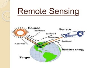
  • 6. Principle of Remote sensing Mapping the earth surface features by reflected electromagnetic energy which is different for different object is measured by sensors on remote platform (satellite).
  • 7. Various Components  The Energy Source  Interaction of Energy with Atmosphere  Interaction of Energy with Target  Recording of Energy by Sensor  Transmission, Reception and Processing  Interpretation and Analysis  Application
  • 8. Electromagnetic Spectrum  The light which our eyes are able to see is comprised of seven colors which which is only a very small portion of EM spectrum coming from the sun to earth’s surface  Energy coming fro the sun comprises energy wave length varying from 1/1000000 μm to
  • 9.
  • 10. Energy Interaction with Objects  EM energy when comes in a contact with objects, some energy is absorbed by the object and some energy is transmitted through the object.  Energy Incident = Energy absorbed + Energy Transmitted + Energy Reflected EI = EA + ET + ER
  • 11. Energy Interaction With Atmosphere  Reflected EM energy from the surface object passes through the atmosphere and reach through the satellite  During transmission of waves some energy absorbed by gases and water vapor.  Absorption and scattering of energy for certain selected waves only thus recording of EM energy by sensors is distributed in that particular length.
  • 12. Energy Interaction with Earth Surface Features Here are some spectral response of main features of earth. • Vegetation • Soil • Water • Snow and Cloud
  • 13. Remote Sensing Platforms I. Balloons II. Aeroplanes III. Helicopters IV. Satellites V. Spacecraft VI. Probes VII. Rovers VIII.Launch vehicles Move in atmosphere Perspective Photo with large error Un-economical Move in space of zero gravity Orthographic Images less errors Repetitive supply of images Initial Cost is more but looking to volume of images it is economical
  • 14. Types Of Remote Sensing Passive Remote Sensing Active Remote
  • 15.  Passive Remote Sensing : In remote sensing sun’s electromagnetic energy which is reflected by different object is received by sensors on satellite to create images is known as passive remote sensing.  Active Remote Sensing : Active remote sensing makes use of sensors that detect reflect responses from objects that are irradiating from artificial generated energy sources, such as radar.
  • 16. Types Of Images  Panchromatic Remote Sensing Images  Multispectral Remote Sensing Images  Hyper spectral Remote Sensing Images  Digital Images
  • 17. Digital Images Processing It means manipulating digital number of pixel for better viewing of image or scene. Digital Image process are as follows:  Radiometric and geometric correction  Image and enhancement  Band Combination
  • 19. Functions Of GPS  To provide coordinates like Latitude Longitude Elevation above mean sea level and time  The Global positioning system is worldwide radio navigation system formed from a constellation of 24 satellites and their ground stations.  GPS use this “artificial stars” as a reference point to calculate positions accurately.
  • 20. Segments Of GPS  Satellite constellation called space segment. The satellite constellation contains the satellites in orbit that provide the ranging signals and data messages to the user equipment.
  • 21.  Ground control / Monitoring network called operational control segment. The OCS tracks and maintains the satellite in space. It also updates satellite clock corrections and ephemeris as well as well as other parameters essential for the determinations of user position velocity and time.
  • 22.  User receiving equipment called user equipment segment. The equipment segment performs the navigation, timing or other related functions.
  • 23. Uses and ApplicationsSome of the uses and application, global, regional and local are as follows: • Navigation • Surveying
  • 25. Surveying GPS is useful to survey various data as follows: • Local property survey • Site survey • Topographical survey • Kinematic survey • Geodetic survey • Contour survey
  • 26. INDIA & GPS  India has launched “मंगलयान” or “Mars Orbiter Mission” The mission is a "technology demonstrator" project to develop the technologies for designing, planning, management, and operations of an interplanetary mission. It carries five instruments that will help advance knowledge about Mars to achieve its secondary, scientific objective. The spacecraft is currently being monitored
  • 27. Yes, Ittu sa step & INDIA will independent in GPS ISRO is going to put one last satellite in IRNSS category to independent for GPS system. We are just one single step behind to be in queue of nations like America, Russia, China, France etc, who has separate GPS system.
  • 28. International Star ISRO  From 2013 to 2015 ISRO has launched two for Australia, five for Canada, one for Denmark Germany & Indonesia, seven for Singapore, six for UK, in total almost 28 satellite and got income of almost 86 million dollar.