A Brief Essay on The Gulf of Kutch and the Gujarat region Based on the study of quot Landscape Pattern, Perception and Process quot.pdf
•
0 likes•4 views

Paper Writing Service http://StudyHub.vip/A-Brief-Essay-On-The-Gulf-Of-Kutch-And-

Recommended
Recommended
More Related Content
Similar to A Brief Essay on The Gulf of Kutch and the Gujarat region Based on the study of quot Landscape Pattern, Perception and Process quot.pdf
Similar to A Brief Essay on The Gulf of Kutch and the Gujarat region Based on the study of quot Landscape Pattern, Perception and Process quot.pdf (20)
More from Tina Gabel
More from Tina Gabel (20)
Recently uploaded
Recently uploaded (20)
A Brief Essay on The Gulf of Kutch and the Gujarat region Based on the study of quot Landscape Pattern, Perception and Process quot.pdf
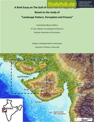
- 1. A Brief Essay on The Gulf of Kutch and the Gujarat region Based on the study of Landscape Pattern, Perception and Process Presented by Bhavna Mishra 4th year, Masters in Landscape Architecture Estonian University of Life sciences Subject: Landscape Pattern and process Instructor: Professor. Simon bell GULF OF KUTCH
- 2. holavira CONTENTS Introduction Understanding the patterns through Google Earth Images The human eye perception of the landscape The Landform – Formation The Geological Survey The landform effects on ecosystem patterns and processes The Natural Disturbances in the Landscape The Historic Settlements and Socio Economic patterns at Present Conclusion (From top Left to Right) The images showing the varying character of the landscape in the region, 1) The White ass sanctuary in the Kutch region, 2)The oil refineries on the Kathiawar coast, 3)The migrating birds on the Great rann of Kutch region, 4) The salt Beds of the little ran of Kutch, 5)The dense settlements in the major towns, 6) The salt industries on the coast, 7) the cracked mud flats of Rann of Kutch, 8) The Dholavira ancient civilization, 9) The flat kite festival grounds (Source:Gujarat Gov. Website)
- 3. INTRODUCTION Kutch, also spelt as Kachch, Kuchh, Cutch, has derived its name from the resemblance of its geographical ha a te isti s a d topog aphi al featu es to the To toise alled as Ka h a i Guja at. The ‘a of Kut h is saline mudflat in the west of India and southern Pakistan. The Great Ranns covers an area of 18000 sq. km. and lies almost entirely within Gujarat State, India, along the border of Pakistan. The Little Rann of Kutch extends north east from the Gulf of Kutch and occupies an area of about 5100 sq. km. The Rann of Kutch has been closed off by centuries of silting. During the time of Alexander the Great it was navigable lake, it is also evident from the remnant of the port structure of 13th century lying in the Jhinjwada village, but it is now an extensive mudflat which gets inundated during monsoon season. There are some 23 islands in the midst of the little rann of Kutch. The area experiences extreme type of climatic conditions. (Wynne1872) This monotonously saline flat surface with annual inundation, have executed the Rann an enigmatic piece of terrain. Lyell,1855 has portrayed the Rann as a singularly flat region which is neither land nor sea which dries up during some part of a year and again inundated by saline water from the sea side and fresh water from the adjoining land area during monsoon. The Rann of Kutch was a gulf of the sea with surrounding coastal towns (Frere, 1870). Wynne, 1872 refuted the idea that the Rann is an uplifted seafloor. He believed that seafloor cannot possess such a monotonous ground character as that of Rann. In fact he advocated that entire plain was a delta of the Indus. However, the present condition is the result of recent upheavals which led to the west ward migration of channels of Indus. Oldham, 1898 and Wadia, 1926 on the other hand shares the different view that is the Rann is a tectonic basin and is now alleviated by several small rivers which are pouring water from the northeast, east and south. The complexity and diverse nature of Gujarat due to the geomorphology makes the Gulf of Kutch a unique landscape. The landform, the climate, and the ecological evidence in Kutch landscape of inundated land, the salt basin, the oil refineries, the salt industries, the migrating birds in the winters in the western coastal region of Great rann of Kutch, the islands in the river basin, the old and new human settlements, the flood plains, the regular earthquake attacks and disaster, the rich flora and fauna and the growing developments in the area makes the character of the landscape dynamic in nature. And this was the reason that encouraged me to study the Gulf of Kutch region and learn the subtleties on the basis of studying landscape pattern, perception and process. THE VARIOUS GEOGRAPHICAL PATTERNS OBTAINED FROM THE GOOGLE EARTH VIEWS FROM THE COASTAL KUTCH TO THE CITY REGION- SHOWING THE LANDSCAPE DIVERSITIES OF THE REGION. 1. THE IMAGE SHOWING THE SALT BEDS NEAR TO THE DELTA OPENING TOWARDS THE MOUTH OF THE GULF, 2. THE IMAGE SHOWING THE PATTERN OF THE GREAT RANN OF KUTCH WHICH KEEPS ON CHANGING DUE TO EFFECT OF WIND, RIVER FLOOD, DRYING.
- 4. 1.THE SALT BED DELTA SHOWING THE BRANCHING PATTERN WHERE THE RIVER MEET THE ARABIAN SEA 2.MEANDERING PATTERN OF THE RIVERS FLOWING THROUGH THE LOTHAL AREA TOWARDS THE OCEAN 1.THE WHITE BEDS DISPLAYING THE SALT DRYING BEDS DISTRIBUTED AMONG DIFFERENT COMPANIES 2.THE BRANCHING PATTERN OF THE RIVERS 1.THE SALT MANUFACTURING INDUSTIRES IN THE SIKKA COASTAL AREA, 2.THE PORT – INDUSTRIAL CITY OF KANSARA Source: Cumulative Environmental Impact Assessment Report,Gandhinagar, 2014
- 5. 1.THE FERRYS, AND THE FISHING SHIPS – APPEAR TO BE FISH IN A POND ,2.JAMNAGAR TOWNSHIP SLOWING GROWING TOWARDS THE OUTSKIRTS 1.THE DIFFERENT LAYOUTS SHOWING OLD SETTLEMENTS AND THE NEW GRID SETTLEMENTS OF TOWNS NEAR THE JAMNAGAR OIL REFINERY, 2. THE PATTERNS SHOWING CULTIVATION AND LAND DISTRIBUTION IN SAJJANPUR AREA THE HUMAN EYE PERCEPTION OF THE LANDSCAPES Attainment of the qualities such as diversity/complexity, coherence, spirit of place, mystery, multiple scales and strength, should be the measure of success for any change to a landscape; they usually occur at a maximum amount within the natural range of variability provided by the climate, landform and ecology. (Bell, 1999) To measure the landscape potential, this study might help in visualizing the landscape in a different perspective that can help to increase the sense of place giving it its new character and a better sense of place. The diversities evidenced in the Kutch region makes the landscape stand high in its spirit of place, scale and strength as evidenced from the human eye study. But the impacts of global warming, flooding, high temperatures, salinity and erosion etc. as studied from the statistics shows the slow erosion of the beauty from beneath through extinction of wild life species, increase of salinity and soil erosion, growing mangrove debilities etc. These character of places should be addressed in individual level with special guidelines in each of these affected areas as they vary in the type of landform, surrounding settlements, the different type of effluences, etc. For example the comparative pictures below showing different coasts of the Kutch region and the measures for landscape upgradation measures for these regions could be different as they differ by their geology, culture, vegetation, wind pattern and the basic use of the place etc.
- 6. From the top, starting from left to right : 1.Ahmedpur-Mandvi Beach, 2.Dandi Beach, 3.Dwarka coast, 4.Koliyak Beach, 5.Gopnath Beach, 6.Narara Beach – Jamnagar (Resource: Gujarat Ecology Commission) There had been many research showing the comparative models of production, population, education, migration, wild life, spread of oil refineries, salt bed rifts in the basin, etc. in the Gulf of Kutch region which study the developments, restoration, conservation, climatic factors etc. And due to lack of funds and many other added factors the implementation process is very slow in India. For example, the map shown gives the example of change in Mangrove cover in the inner Gulf of Kutch. (Gautam, 2007) At the Workshop on Cumulative Environmental Impact Assessment in Gandhinagar, 2014. The pressure zones identified in the areas 1. Western Marine NationalPark and Sanctuary (MNPS), 2.Central MNPS, 3.Eastern MNPS, 4.Islands MNPS, 5.Southeastern Gulf of Kachchh (GoK), 6.Northeastern GoK, 7.Eastern central GoK, 8.Western central GoK, 9.Northwestern GoKSector. India is in the progressive stage of environmental research development at present and the best period at which the study based on landscape pattern can yield profitable results.
- 7. The map displaying the Morphogenetic regions of Kachchh district (Kar, 2011) THE LANDFORM OF THE GULF OF KUTCH REGION The shallow Gulf of Kachchh separates the peninsulas of Kachchh and Kathiawar. The physical features of Kachchh are characterised by the contrasting occurrence of extensive plains and highlands with lofty hills (Biswas, 1977). The highlands are the Mainland of Kachchh, Wagad, Patcham, Khadir, Bela and Chorar (Banaskantha district) while the extensive plains are manifested by the Great Rann of Kachchh on the north, the Little Rann of Kachchh on the east (connecting the Great Rann of Kachchh and the Gulf of Kachchh) and the Banni plains (Roy, 1973) The Mainland of Kachchh is the biggest among the five highlands of Kachchh. It is surrounded by the Great Rann and Banni of Kachchh to the north, the Little Rann to the east, Gulf of Kachchh to the south and Arabian Sea to the west and southwest. The mainland consists of two main east-west running hill ranges: (i) the northern range that occur along its northern margin with the Great Rann and Banni, and (ii) the Charwar Range which occur in the middle of the Mainland. There are two hill ranges in the Kachchh mainland which are formed of igneous intrusions running from east to west. The Mainland is bordered to the west and south by a wide belt of coastal plain. The western coast is made up of mud flats of several large creeks while the south coast forms a gentle, sandy beach bordering the deep blue sea. Patcham Island shows physical features similar to the Kachchh Mainland and
- 8. consists of two east to west running hill ranges, namely, Kaladongar (Black hills) range and Goradongar (White hills) range separated by central valley. The Khadir Island is featured by a hill range along its northern margin which forms a prominent escarpment facing the Great Rann. The entire island is formed of the gentle southern slope of this hill range. A high hill with prominent escarpment on the north, facing the Rann, runs along the entire length of the island. The height of the hill range does not drop much to the east and end up to the prominent hill called as Mouwana. This hill range known as Bela hills and the Mouwana hill is separated by a wide saddle in between. A central hilly terrain known as Wagad (Vagad) hills, and a long narrow hill range along the southern margin of Wagad, runs from Wamka on the west, through Adhoi, to Gon at the eastern tip of the area. The image displaying Kala dongar geosite: Location (23°55'59.59"N, 69°48'49.33"E) shown in google earth; Kala dongar site, the highest point in Kutch, from where a panoramic view of Great Rann is seen. (Courtesy: Dr. Bhawanisingh Desai, PDPU) (Left) a) Dhinodhar Hill Geosite: Volcanic plug and rock patterns of columnar joints. b) Dhinodhar Hill lava remains c) one of the eruptive centers of Deccan Trap, Kutch .
- 9. (Right corner)The location of Jumara dome north-flank viewing north over Banni mud- flat. THE GEOLOGICAL SURVEY The Indus shelf hinge extended perpendicular to the depositional axis which formed a first order basement high, i.e. median high, across the middle of the embayment (Biswas, 1987) trending NNE-SSW. This meridional high passes transversely across both positive and negative elements of the basin so that the uplifts plunge bilaterally and the sub-basins have a central high or shallow region. The basin is deeper to the west of the high with thicker accumulation of sediments showing facies change from shallow to deeper shelf; and it is shallow to the east of the high with less thickness of sediments showing facies change from shallow marine to intertidal and fluvial. The Median High that controlled the facies and thickness of sediments is a tectonised zone along the hinge line of the basin and is featured by intense faulting, folding and intrusions. Structurally, the basin is featured by residual basement ridges along the primordial faults that are parallel to the major Precambrian tectonic trends (Biswas, 1982). These ridges are foot wall uplifts with intervening half grabens that remained as the passive highs within the basin during the deposition. Later these highs were rejuvenated by the reactivation of the faults and are manifested in sub-parallel uplifts with narrow flexures along the master faults (Biswas, 1980). The vast ud a d salt flats of the G eat a d the Little ‘a s of Ka h hh a d Ba i plai s o upied the esidual dep essio s that surrounded the uplifted areas. (Above) Geological and structural map of Kachchh Basin (Biswas and Deshpande, 1970 & 1973; and Biswas, 1982 & 1987).
- 10. The uplifts are oriented E-W along five parallel faults (Fig.2.2): (1) Nagar Parkar fault (NPF), (2) Island Belt fault (IBF), (3) South Wagad fault (SWF), (4) Kachchh Mainland Fault (KMF), (5) North Kathiawar fault (Biswas, 1980). Block tilting along these faults during the rift phase extension gave rise to four sub-parallel linear ridges: Nagar Parkar uplift (NPU), Island Belt uplift (IBU), Wagad uplift (WU), and Kachchh Mainland uplift (KMU). Accordingly, the IBU is broken into four individual uplifts presumably by unexposed transverse wrench faults as evidenced by relative displacements and orientations: Pachcham uplift (PU), Khadir uplift (KU), Bela uplift (BU), and Chorar uplift (CU). The Kachchh Mainland fault (KMF) sidestepped to left with the shift of uplift form south to the north and continues eastward as South Wagad fault (SWF). This left stepping KMF/SWF seems to be the principal strike-slip fault that divided the basin into two main domains of sedimentation, the Banni half-graben (BHG) and Gulf of Kachchh half-graben (GOK HG) which acted as principle intra-rift fault along the rift axis (Biswas, 2002). Image showing the geological uplifts in the region of Gulf of Kutch (Biswas,1970) THE LANDFORM EFFECTS ON ECOSYSTEM PATTERNS AND PROCESSES Landforms can cause environmental gradients, affect the movement of materials and energy, affect ecosystem disturbances and local geomorphological processes (Bell, 1999). In the region of Kutch, we can see the extensive variation of Landforms featuring the saline river delta, the rich aqua-marine and wild life habitats, the cracking muddy flat lands, the igneous hill ranges, flood plains, river drainage patterns and the greenery in patches of mangroves, cultivation land and arid grasslands.
- 11. (Biswas,1970) Maps showing the Soil Erosion, Salinity and Hydrology maps (Source: Gujarat Government Maps, 2005) THE UNIFORMLY FLAT BEDS OF THE RANN OF KACHCH Frere (1870) e tio s that the thick sheets of solid salt of Kutch, on a perfectly level surface of dry sand and clay, the most probable and most consistent with observed facts appears to be, that it is formed by the gradual evaporation of the intensely saline salt water which is always present in the sub soil, and which oozes to the surface by capillary action or under pressure, from rain in the upper country, and from high tides in the creeks which intersects the plains where the sheets of salt are found. The constant recurrence of surface agitation from earthquakes, especially during the time when the surface is annually covered with a couple of feet of water, supplies exactly the kind of cause which would account for the unifor ity of the le el . Photo 1&2 source: (Gautam,2007) The flat saline delta makes the region very hot and arid, so it accounts to very less vegetation, no settlements, no wildlife in the region (Frere, 1870) THE HALOPHYTES AND XEROPHYTES Halophytes are found growing in muddy swamps of estuaries and inter-tidal zone because of the presence of ample of water in the upper layer of the soil, they have shallow normal roots. In addition to it the soil
- 12. of the coastal region is poorly aerated and contains very little oxygen because of water logging for which the roots do not get sufficient aeration and in order to compensate the same, the halophytes develop special type of negative geotropic roots called as Pneumatophores. Pneumatophore develops on underground roots and project in the air above muddy soil, which helps in gaseous exchange; this is a typical characteristic of mangroves in the clayey soils found in the study area. Similarly, the Xerophytes have adopted to grow in the area with scanty rainfall and underground water with water holding capacity. The present scenario of morpho-ecological adaptations of halophytic and xerophytic plants exhibits there response to the complete domain of physical environment which includes climatic parameters and relief condition surface texture moisture content and water depth during rainy season.(Roy,1977) THE FAUNA Among vertebrate fauna Wild Ass Sanctuary in LRK (Little Rann of Kutch) provides breeding and roosting habitat for large number of diverse avifauna. A variety of resident and migratory birds belonging to at least 178 species occur in the Wild Ass Sanctuary of LRK (Singh et all, 2001). About 81 terrestrial (9 migratory extra-limital) and 97 water birds (42 migratory) have been recorded from different 16 sites of the wild ass sanctuary in LRK. However, during 2004 survey conducted by Corbett Foundation, 186 bird species were recorded from this area. Rare and endangered bird species found in the LRK includes Hobara Bustered (Chlamydotis undulate), Lesser Flamingo (Phoenicopterus minor). In 1998, a large breeding colony of Lesser Flemingo was observed in the LRK. Further more, a threatened waterfowl all over the world, has been regularly seen in the Wild Ass Sanctuary of LRK. So, this sanctuary is recognized as wetland site of international importance. Among herpetofaunal species, four species of amphibians, two species of turtles, 14 species of lizards, 12 snakes and one crocodile have been recorded from this region. Herpetofaunal species like Indian flapshell turtle (Lissemys punctata), spiny tailed lizars (Uromastyx hardwickii), saw-scaled viper (Echis carrinatus), cobra (Naja naja) are very common in LRK. Total 33 species ECOLOGICALLY SENTIVE ZONES (SOURCE: GAUTAM, 2011)
- 13. of mammlas have been enlisted from Wild Ass Sanctuary of LRK which includes 5 ungulates, 14 Carnivores, 1 Logomorph, 6 Redentia and Chiroptera, 1 Pholidota, 3 Insectivore and 1 species of Primate. Vast flat saline desert of LRK having unique and fascinating wildlife in general and Indian Wildlife Ass (Equus hemionus khur) in perticular. The LRK is quite rich in biodiversity and is famous for the last remaining population of Wild Ass (Equus hemionus khur) (Meena et al., 2008), the only gene pool in the world and one of the six geographical varieties or sub-species surviving on the earth. SOURCE: FOREST DEPARTMENT, GOV. OF GUJARAT, 2012
- 14. NATURAL DISTURBANCES IN THE LANDSCAPES - MAJOR EARTHQUAKES WITNESSED 1819 AND 2001 This fas i ati g la ds ape is the esult of the complicated interaction of sea level changes, climatic fluctuation and tectonic movement during last 10,000 years. Seismically, the area is very sensitive as it is frequently visited by ea th uake , (Mallik, 1999). Such type of active seismicity in the region may be attributed to its nearness to the junction of the geo-synclinal belt of Sindh- Baluchistan and the western continental margin and also because of the trio- junction which is formed by the Indian, Arabian and African plates. The Kutch has been visited by earthquake through its geological history. Both Rann has witnessed & experienced significant geomorphic changes because of the tectonic movements and sea level changes during Holocene. (Wadia, 1975) A large part of Rann was a marine gulf and that is generally emerged out of the sea in the course of the last yea s (Me h, 2001). Marine conditions in the Ranns continued to prevail even during historical times (Mac Murdo, 1824; Wadia, 1975). Gradually recession of the sea changed the area to an estuary. In view of Mallik (1999), till recent, a few thousand year back, it was a delta complex, which received water & sediments of a number of Himalayan Rivers and rivers viz. Sindhu (Indus), Sarasvati and Shatadru (Proto-Sutluj) were flowing across the northwestern plain of India, emptied their water into a shallow sea that now marks the site of Rann of kuchchh . All along the banks and near the mouth of these paleo-rivers were located important towns of Indus valley (Harappan) civilization, which is now perceived to be destroyed by the tectonic & seismic upheavals in the past. (Image showing in the right: the bhuj earthquake 2001, source: The Newspaper Daily Indian express) THE CLIMATIC ASPECT AND LANDFORM INFLUENCING SETTLEMENT PATTERNS The image showing the rainfall(in mm) in the regions in monsoon season 2010 showing the scarcity of rainfall in the desert region and heavy rainfall towards the western coast displays a major role of the landform affecting climatic variations. But due to the slope of the land the river basin in little ran of Kutch and great ran of Kutch gets inundated and floods the villages in the fringe area. (Kar,2011)
- 15. DHOLAVIRA, THE ANCIENT SETTLEMENTS DISPLAY THICK WALL CONSTRUCTION AND WATER CONSERVATION SYSTEM: The City of Dholavira located in Khadir island of the Rann of Kutchch belonged to matured Harappan phase. Today what is seen as a fortified quadrangular city set in harsh arid land, was once a thriving metropolis for 1200 years (3000 BCE-1800 BCE) and had an access to the sea prior to decrease in sea level. The excavated site of Dholavira demonstrates the ingenuity of Harappan people to evolve a highly organized system of town planning with perfected proportions, interrelation of functional areas, street-pattern and an efficient water conservation system that supported life for more than 1200 years (3000 BCE to 1800 BCE) against harsh hot arid climate. Its scale of enclosures, the hierarchical street pattern and defined spatial utilization i.e. land for industries, administration etc, as well as infrastructure like waste water disposal system, show the sophisticated urban life enjoyed in this rocky metropolis.(UNESCO,2001) The first settlements as studied in this region with the hot and arid climate managed to survive in this rocky foothills of Khadir island by creating proper water storage systems through rain and river water. (SOURCE: UNESCO.org) BHUNGA SETTLEMENTS IN BANNI FOOTHILLS OF KACHCH MAINLAND DISPLAYING THE USE OF NATURAL MATERIALS IN CONSTRUCTION, THICK MUD/STONE BRICK WALLS WITH SMALL WINDOWS: In mud or stone construction of bhunga houses, the walls are thick. This makes the surface less penetrative for the heat. The mud plaster done on the walls is also less conductive which adds to the thermal comfort inside the bhunga. Bhungas have small openings, this helps in extreme climate of the region. Thatch roof is a weak conductor of heat and adds to the thermal comfort. The roof overhang of a bhunga comes quite low casts shadows on the walls and protects the walls from the direct sunrays. Due to its circular shape, there is only one line which is directly perpendicular to the sunrays hitting the surface of the structure at a time. Hence, most of the heat is reflected away, making it more comfortable during the hot season.(Gautam,2011) From Top (Left to right) 1.The structure of the banni house, 2.The settlement pattern of the ancient civilization, 3.The typical Banni family settlement layout. ( Source: Biswas,2007)
- 16. SOCIO ECONOMIC PATTERNS AT PRESENT AND EFFECTS The landscape of the little and Greater Rann of Kachchh is low land saline desert which remains partially submerged during monsoon and early winter months. Therefore it is inhospitable for human habitation. But fringe area of this saline low land of Little Rann of Kutch is occupied by 108 villages having 52600 families (CESC, 2008). Along the fringe area, a number of developmental and infrastructural activities are coming up. Besides, the traditional and conventional agriculture practices are shifting towards intensive, commercial and mechanized farming (Sinha & Goyal, 2006) However, many of the local communities are still dependent on subsistence farming and small scale animal husbandry. Some marginal communities are involved in salt extraction and seasonal fishing. Human population residing in the study area are some sub-communities of Hindus, Muslims and Jains. In agriculture, major crops are Juwar and Bajra –staple food of the locals as well as patchy cultivation of pulses, oil seeds and cotton (Sinha, 1993). The land use pattern in the 3 districts around the Gulf reveals that an overwhelming portion of about 85% forest cover of the coastal region falls in the Kachh district and the coastal region of the Jamnagar district, adjoining an ecologically sensitive Marine National Park and Sanctuary, accounts only for 14% of the total forest cover of the region as a whole. The details of land use cover (2013) are illustrated in the map and the table below. The irrigated land of Jamnagar district alone accounts for 60% of the region which is equivalent to 16% of the cultivable coastal land of the district. 90% of the total irrigation is through ground water. These conditions not only help accelerate salinity ingress, but will also affect ground water balance disturbing intertidal ecology. Conditions in the Kachch district do not reveal any rosy picture either, as ground water irrigation accounts for 72% of the irrigated land due to lack of adequate surface water. As of 1996, such water harvesting p a ti e has esulted i Ma d i a d Ba hau taluks to e lassified da k i the Ka h h dist i t, he eas A dasa, Mu d a, Okha a d Jodia o side ed as G ey . (Biswas,2014) LANDUSE MAP-2013 ( Biswas,2014)
- 17. (Biswas, 2014) SOURCE: GUJARAT INDUSTRIAL DEVELOPMENT CORPORATION MAP, GUJARAT GOV.,2013
- 18. The anthropological advances in the landscapes adversely affects the nature and bio diversity in this region. Prolonged exposure, heavy siltation/deposition of silt, commercial exploitation of coral sands by cement Company at Sikka, mining operations and chronic oil pollution due to shipping activities, discharge of oil derived chemicals, oil spilage and leakage from Salt Manufacturing companies and Oil refineries lead to major problems to the biodiversities in the region and the main example of Coral reef decay is shown below. (Biswas, 2014) CONCLUSION Gujarat is one of the most industrialized states in India. It has grown at an impressive rate of between 5 and 5.5 per cent per annum in the 1990s and poverty levels have been lower compared to many Indian states. However, studies have shown that it faces many environmental threats as the state being geophysically and agro-climatically diverse where different states are differently endowed. (Iyengar & Bandopadhyay, 2008) The landscape change in Gujarat is fastest, where major changes to land management practices are occurring and where the landscape is under severe development pressure. In case of many developed cities, the trends are for industrialization, intensive land use, urban growth and infrastructure development, which pay little or no heed to natural or cultural patterns, except the most constraining (Bell, 1999) whereas, in case of developing cities like Gujarat, there are problems related to economy, soil erosion, rapid urbanization, natural calamities, desertification, and conflicts between highly developing industries and the poor populations in the coasts. There had been many measures taken for sustainable developments in the region and have shown moderate results. In 2007 to 2012, there had been measures taken to empower urban poor, clean Gujarat campaign in 2007, regulations set for residential towns in 2009, regulations for rehabilitation and redevelopment of slums in 2010 and many more for education, tourism, conservation etc.(Gautam,2012) There is considerable scope of implementing the landscape pattern/process model at a community level (Bell,1999)in Gujarat, facilitated by trained people, perhaps provided by aid agencies and any plan model must be based on an understanding of patterns and processes of the region, for a better evaluation. SETTING UP THE METHODOLOGY FOR THE KUTCH REGION SELF ASSESSMENT BASED ON THE STUDY: THE STEP-WISE FUTURE SUSTAINABLE MEASURES WHICH CAN BE TAKEN FOR FURTHER DEVELOPMENTS IN THE GULF OF KUTCH REGION: 1. DETERMINING THE ENVIRONMENTAL CHARACTERISTICS OF THE REGION 2. LOCATING THE MAJOR PRESSURE ZONES 3. ASSESSING THE CARRYING CAPACITY OF CURRENT AND FUTURE DEVELOPMENTS OF THE SITES 4. LINKING PRESSURE WITH IMPACT OF FUTURE GROWTH FOR BETTER RISK MANAGEMENT MEASURES 5. INTEGRATING ALL ABOVE INTO A MODEL EITHER IN COMMUNITY LEVEL, DISTRICT LEVEL OR REGIONAL LEVEL DEPENDING UPON THE PRESSURE, SPREAD, NEED, IMMEDIACY ETC.
- 19. The main objective behind this specific study was to acquire a deeper insight for design solutions in the landscape by understanding the natural patterns and processes, linked with perception and aesthetics. (Bell, 1999) Through this analysis based on the study of Landscape Pattern, Perception and Process we can make an appraisal of the environmental protection measures, revitalization of communities and landscapes and sustainable solutions for landscape and environment, with the better understanding of landscape in both micro and macro level for the endurance of the landscape and life in any region of the world. DIFFERENT MAPS OF GUJARAT (SOURCE: GUJARAT.GOV.IN)
- 20. REFERENCES Wynne, A. B., 1872. Memoir on the geology of Kutch, Indian Geological Survey Memoir 9, 29–47 Lyell, C. (1855). A Manual of Elementary Geology, John Murray, London,655 pp Frere, H. B. E. (1870). Notes on the Runn of Cutch and neighboring region, J. R. Geograph. Soc. London 40, 181–207. Oldham, R. D. (1898). A note on the Allah Bund in the northwest of theRunn of Cutch, Geological Survey of India Memoirs28, 27–30. Bell, S., 1999. Landscape: pattern, perception and process. Routledge. Gautam, I.P.,2012. A presentation on land use and urban transport – ICRIER s P og a o Capa ity Building and knowledge dissemination – Government of Gujurat. Gujurat ecology Commision Workshop on Cumulative Environmental Impact Assessment in Gandhinagar, 2014. Roy, B. (1973). Pattern and causes of inundation of Rann of Kutch, Ph.D.Dissertation, M.S. University of Baroda, India, 170 pp B. G. Desai a d “. J. Patel, Uppe Callo ia -Middle Oxfordian Belemnite Assemblage from Jara Dom Ka h hh, Jou al Geologi al “o iety of I d e, Weste ia, Vol. 7 , No. 3, 2009, pp. 343-356. “. K. Bis as a d “. V. Deshpa de, The Base e t of the Mesozoi “edi e ts of Kut h, Weste I dia, Bulletin of Geology, Mining & Metallurgical Society of India, Vol. 40, 1968, pp. 1-7. Biswas N, AM Dixit, P Kumar, L Kumar, KD Pathak, and MI Patel. 2010. Economic Valuation of Coral Reef Systems in Gulf of Kachchh. Final Report. World Bank-aided Integrated Coastal Zone Management (ICZM)Project. Submitted to Gujarat Ecology Commission, 158pp. Government of India Ministry of Power. 2012. Report of the Comptroller and Auditor General of India on Ultra Mega Power Projects under Special Purposes Vehicles for the Year Ended March 2012. Performance Audit Report No. 6 of 2012-13. Biswas, S. K., Regional tectonic framework, structure and evolution of the western margin basins of India. Tectonophysics, 1987, 135, 307–327. Biswas, S. K., Bhasin, A. L. and Ram, J., Classification of sedimentary basins of India in the framework of plate tectonics. Proceedings of the Second Symposium on Petroliferous basins of India, KDMIPE, Dehradun, 1994, vol. 1, pp. 1–42. Wafar, M.V.W, 1986. Corals and Coral reefs of India, Proceedings of Indian Academy of Science, suppl., 19-43. Gupta, S.K., 1972. Chronology of the raised beaches and inland coral reefs of Saurastra coast, journal Geology, 7: 1-7. CESC (2008) Biodiversity Conservation and Rural Lielihood Improvement Project. Indicative Plan. Centre for Environment and Social Concerns. Ahmedabad.
- 21. Ray, Arijit, Pal, D., Patil, D., Biswas, S. K. and Das, B., Petrology, geochemistry and palaeomagnetic studies of Sadara intrusive, Pachham Island, Kutch, Western India – Evidence of rift-related magmatism, manuscript under preparation. Roy, B., and S. S. Merh (1977). Geomorphology of the Rann of Kutch andclimatic changes, in Ecology and Archaeology of Western India, D. P.Agrawal and B. M. Pande (Editors), Concept Publishing Company,Anand Nagar, Delhi, India, 195–200 Merh, S. S., and P. P. Patel (1988). Quaternary geology and geomorphology of the Ranns of Kutch, in Proc. Seminar on Recent Quaternary Stud-ies in India, M.S. University, Baroda, India, 377–393 Gujarat CM Website. http://www.narendramodi.in/those-who-know-the-tourism-sector-know- potential-there-is-gujurat-cm-at-gujarat-travel-mart. Mi ist y of Tou is , GoI, th Fi e Yea Pla , . http://planningcommission.nic.in/aboutus/committee/wrkgrp12/wgrep_tourism.pdf Kut h, Guja at Map. Google Maps, Web, 2013. “i gh P asoo Ku a , ‘u hi “i gh,Bhakat Dipa ita & “i gh Gu deep, . I pa t of Cli ate Cha ge in Mining Region – A Case “tudy , Asia- Pasific Bussiness Review, 6(1), pp. 128 – 138. Meena, R.L., V.T. Korvadia, A.B. Dave and P.N. Joshi, 2008. A Note on Greater Rann of Kachchh, Kachchh District, Gujarat with Special Reference to Flamingo City. Gujarat State Forest Department, Gujarat, pp: 1393-1397. Meena, R.L., Y.L. Verma, V.T. Korvadiya, B.J. Pathak and A.R. Kshatriya, 2005. Kachchh Biosphere Reserve (A Management Plan for Protection, Conservation, Research and Development). Gujarat State Forest Department, Gujarat. Patel, G.D., 1971. Gujarat State Gazetteers-Government of Gujarat. Gujarat State, Ahmedabad. Singh, H.S., 2001. Natural Heritage of Gujarat. GEER Foundation, Gandhinagar, pp: 262. Vijaykumar, V., P.N. Joshi, J. Joshua and G.A. Thivakaran, 2007. Integrated Rann Reclamation and Development in kachchh District, Gujarat. Gujarat Institute of Desert Ecology, Gujarat, India.