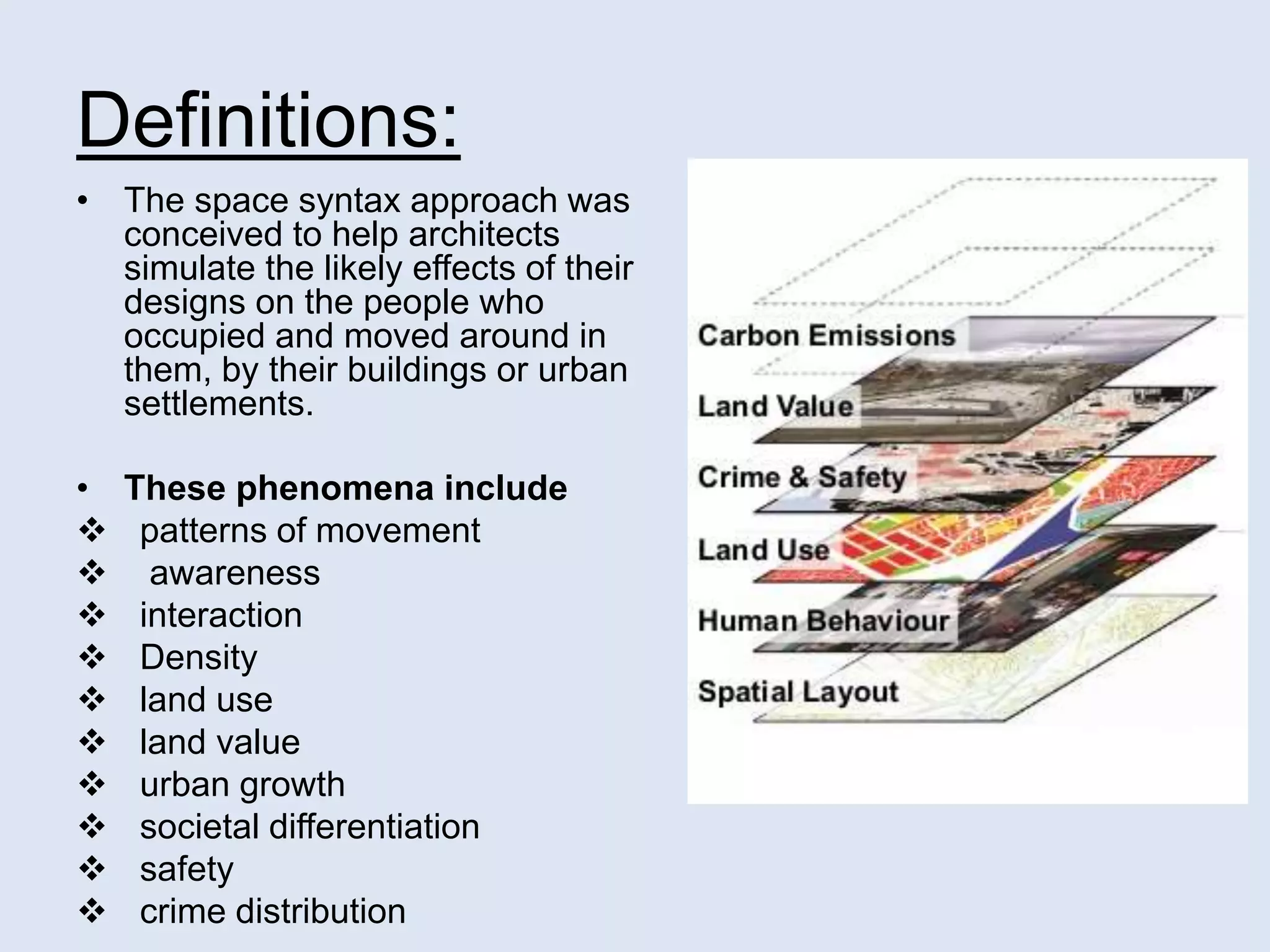
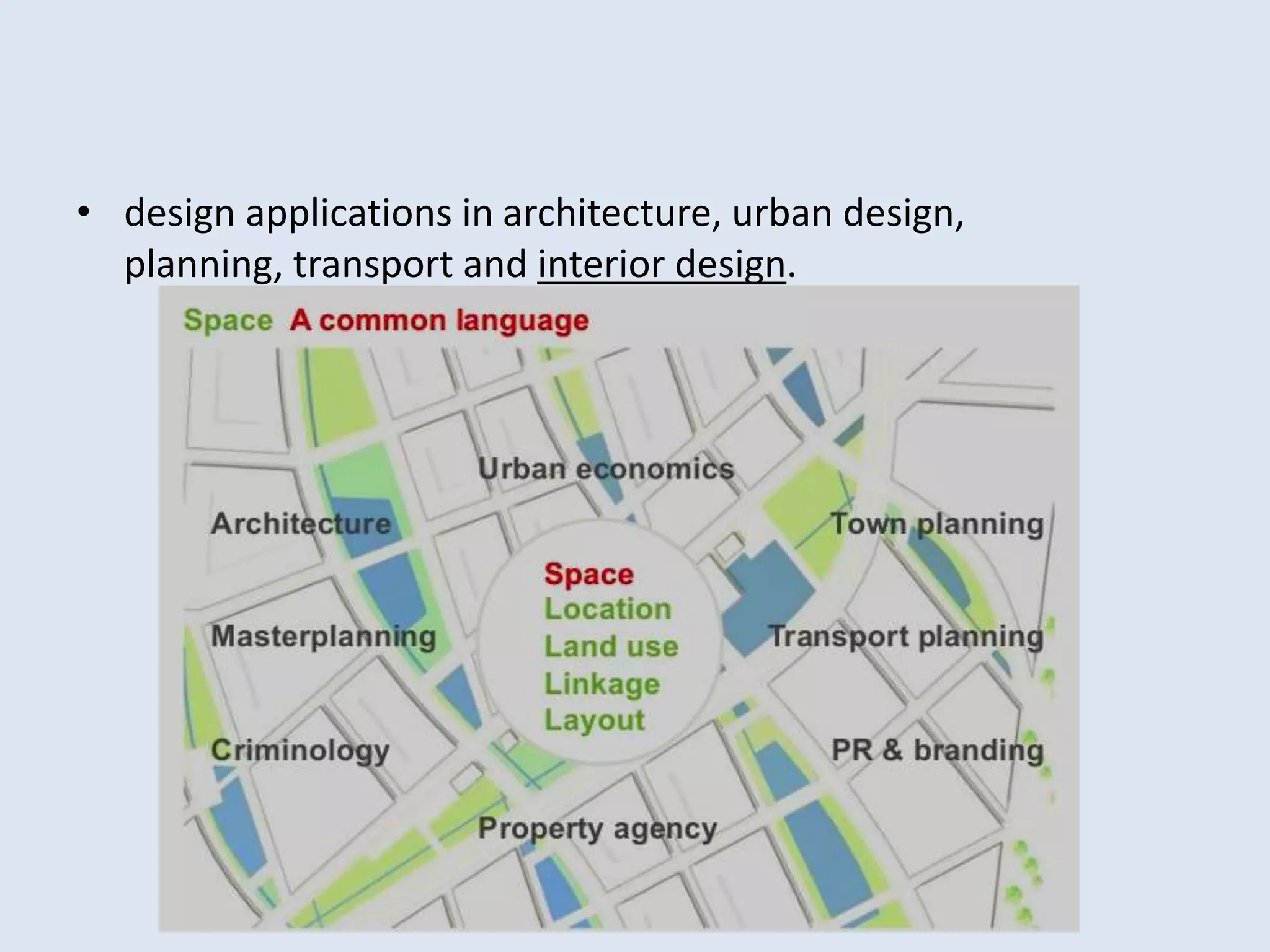
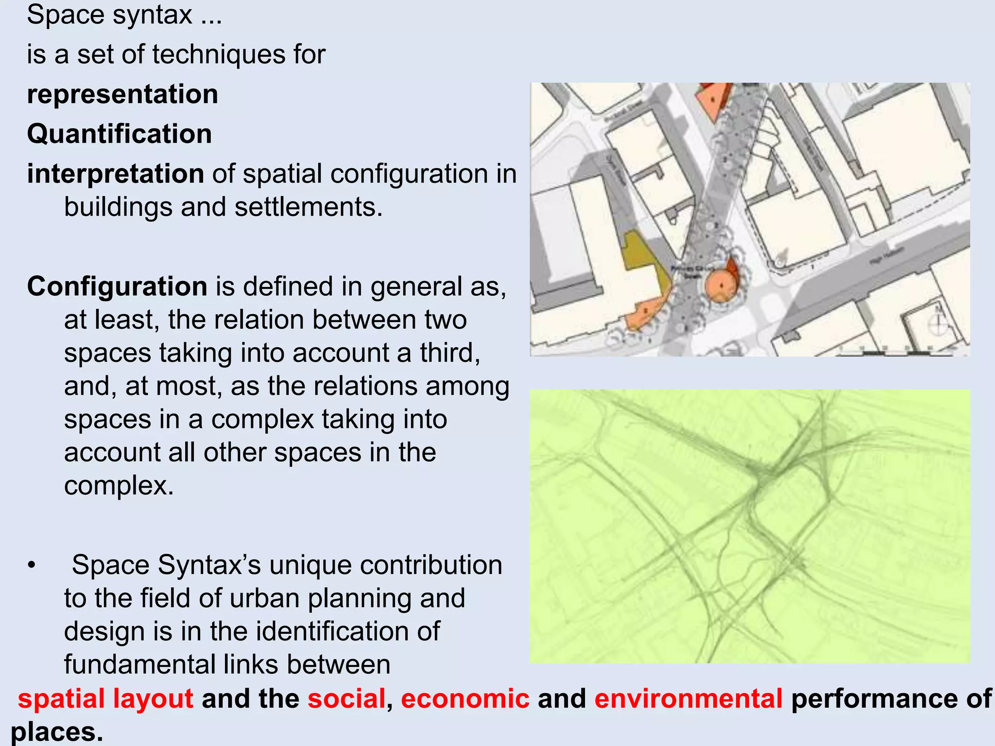
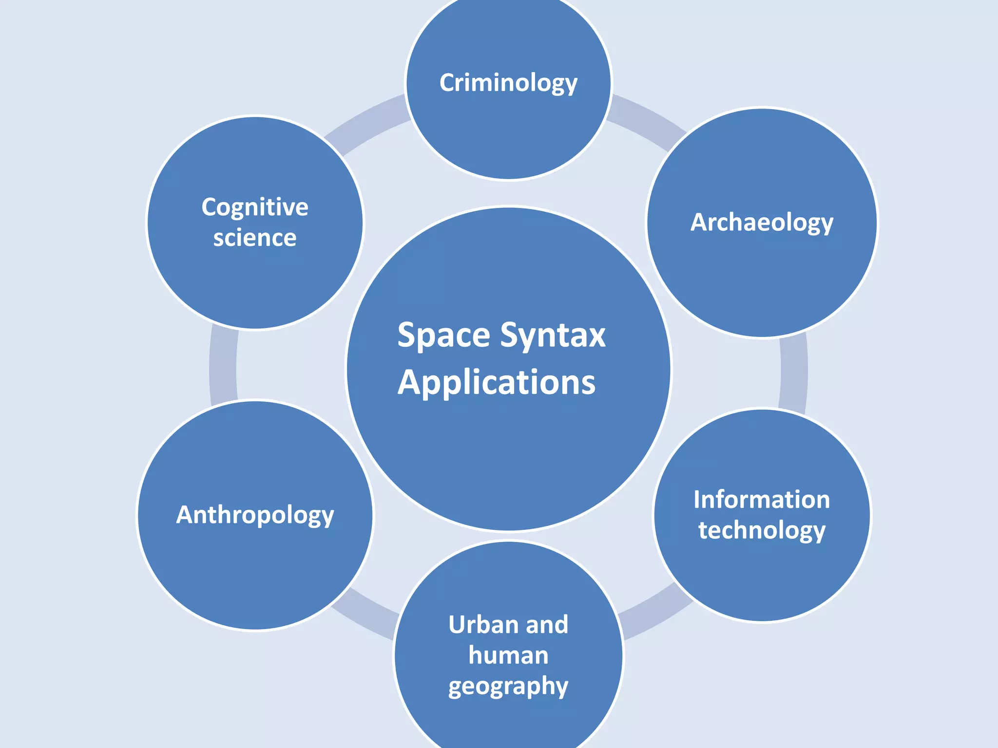
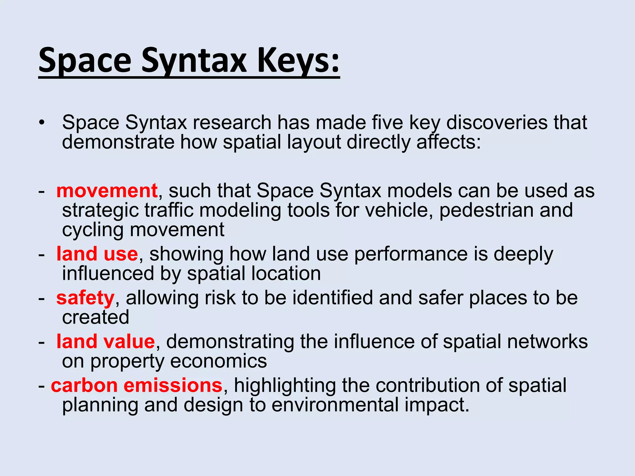
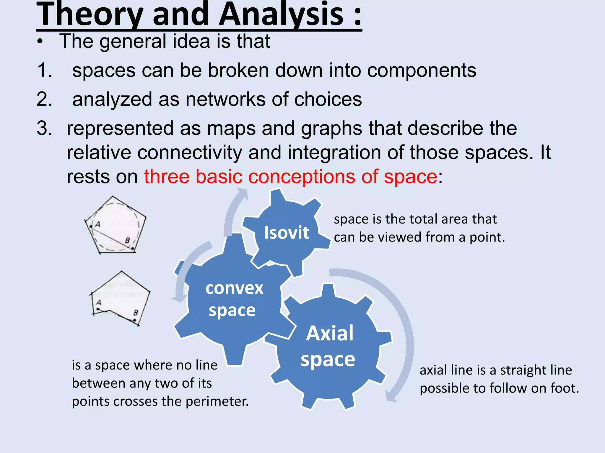
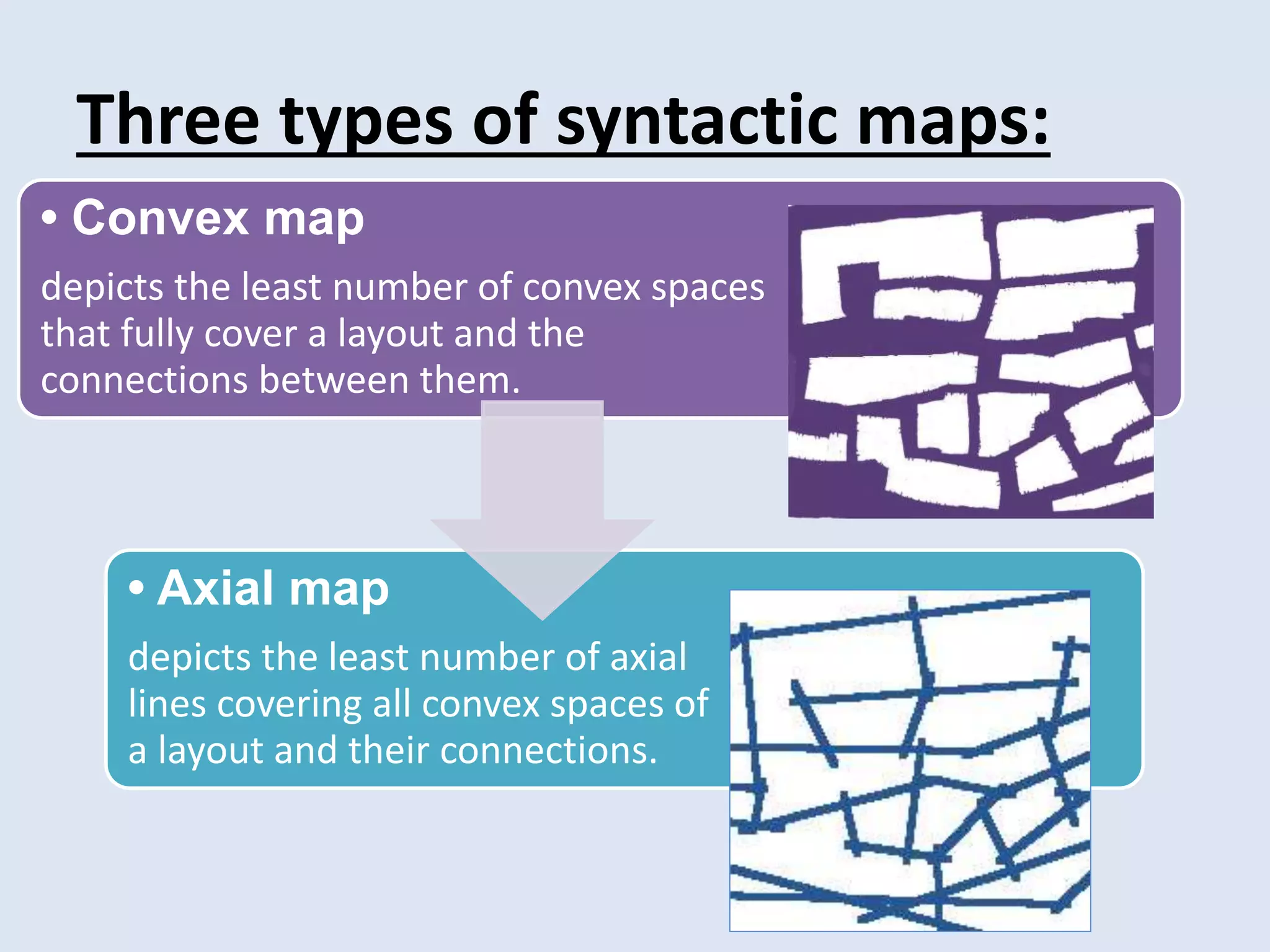
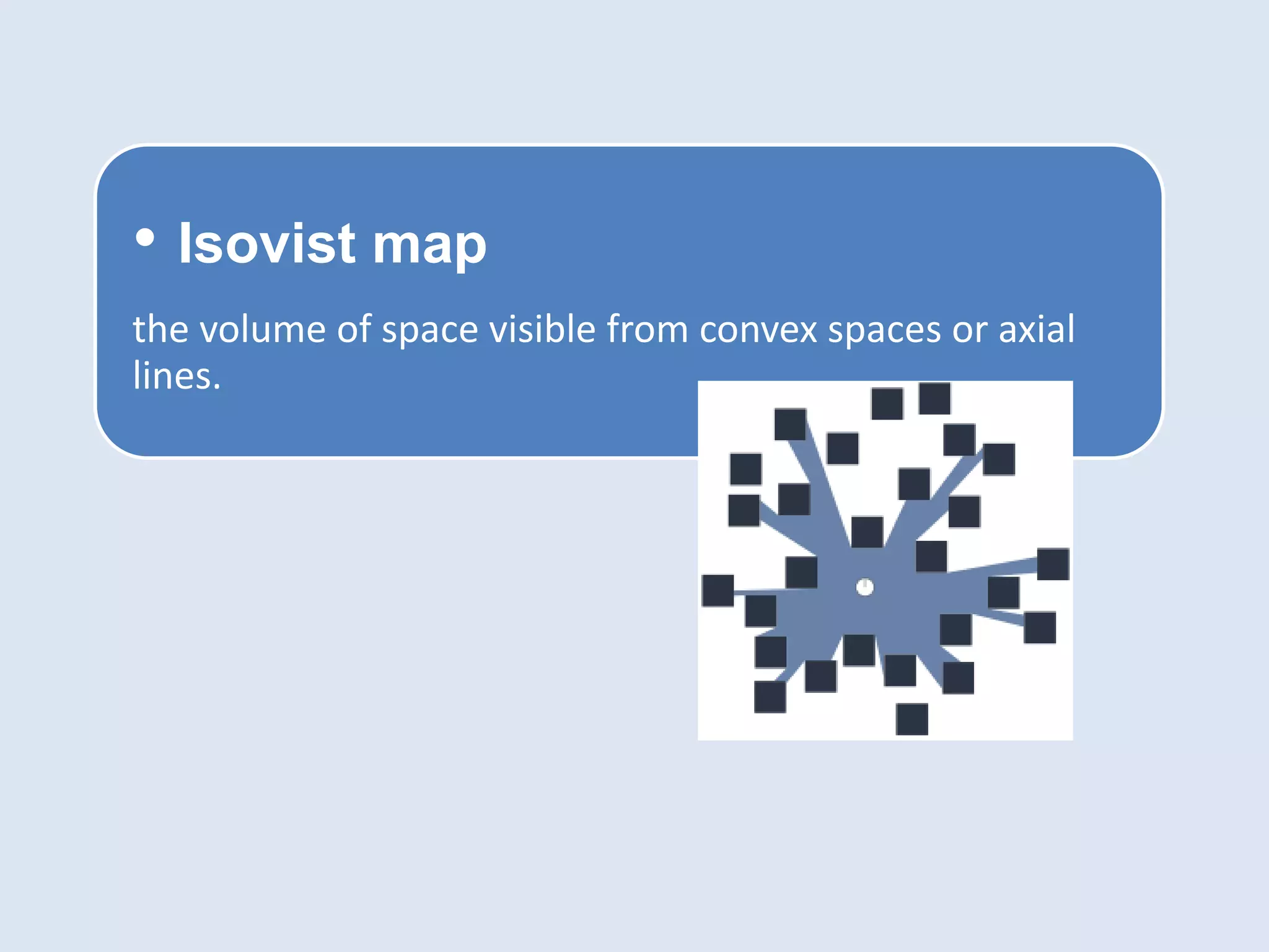
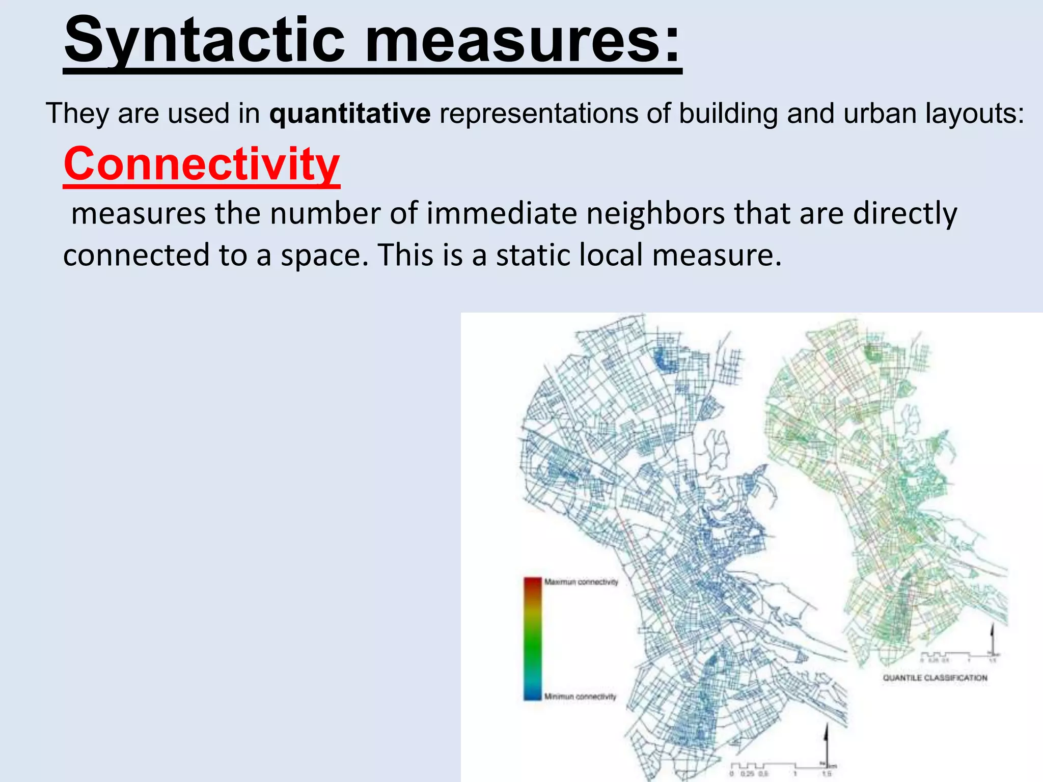
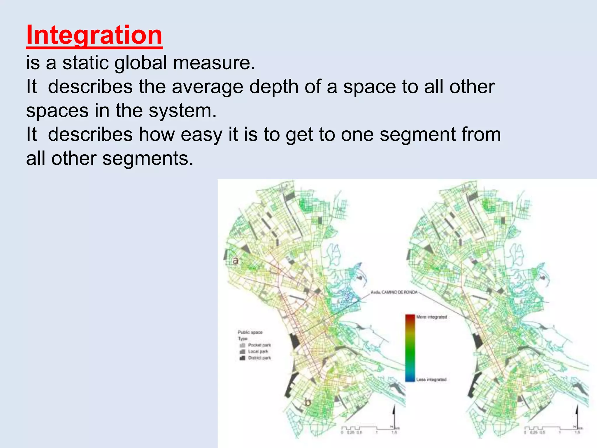
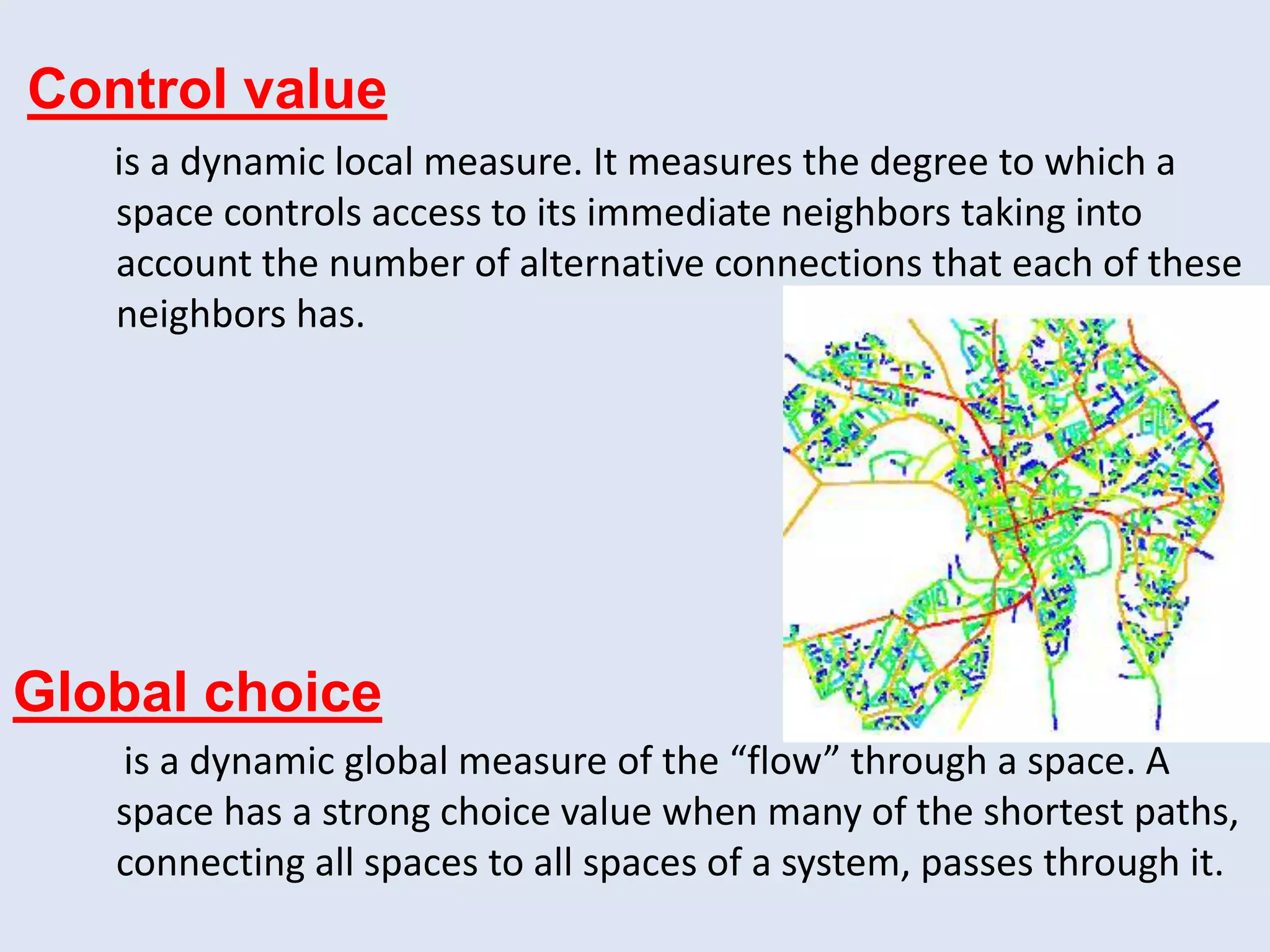
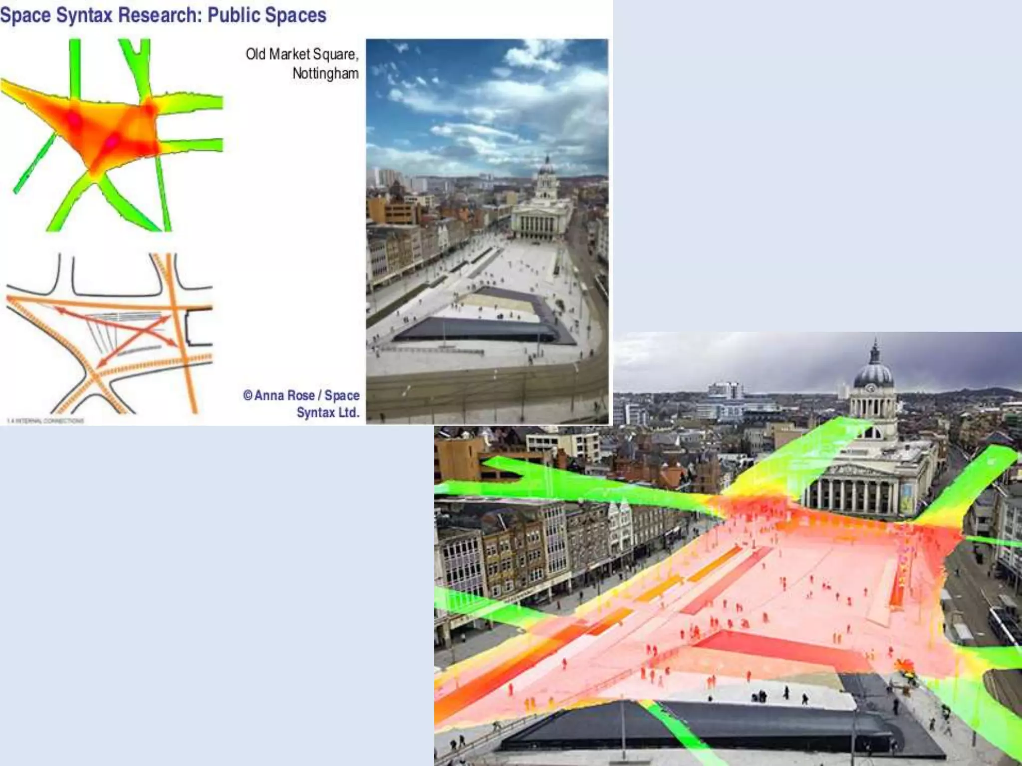
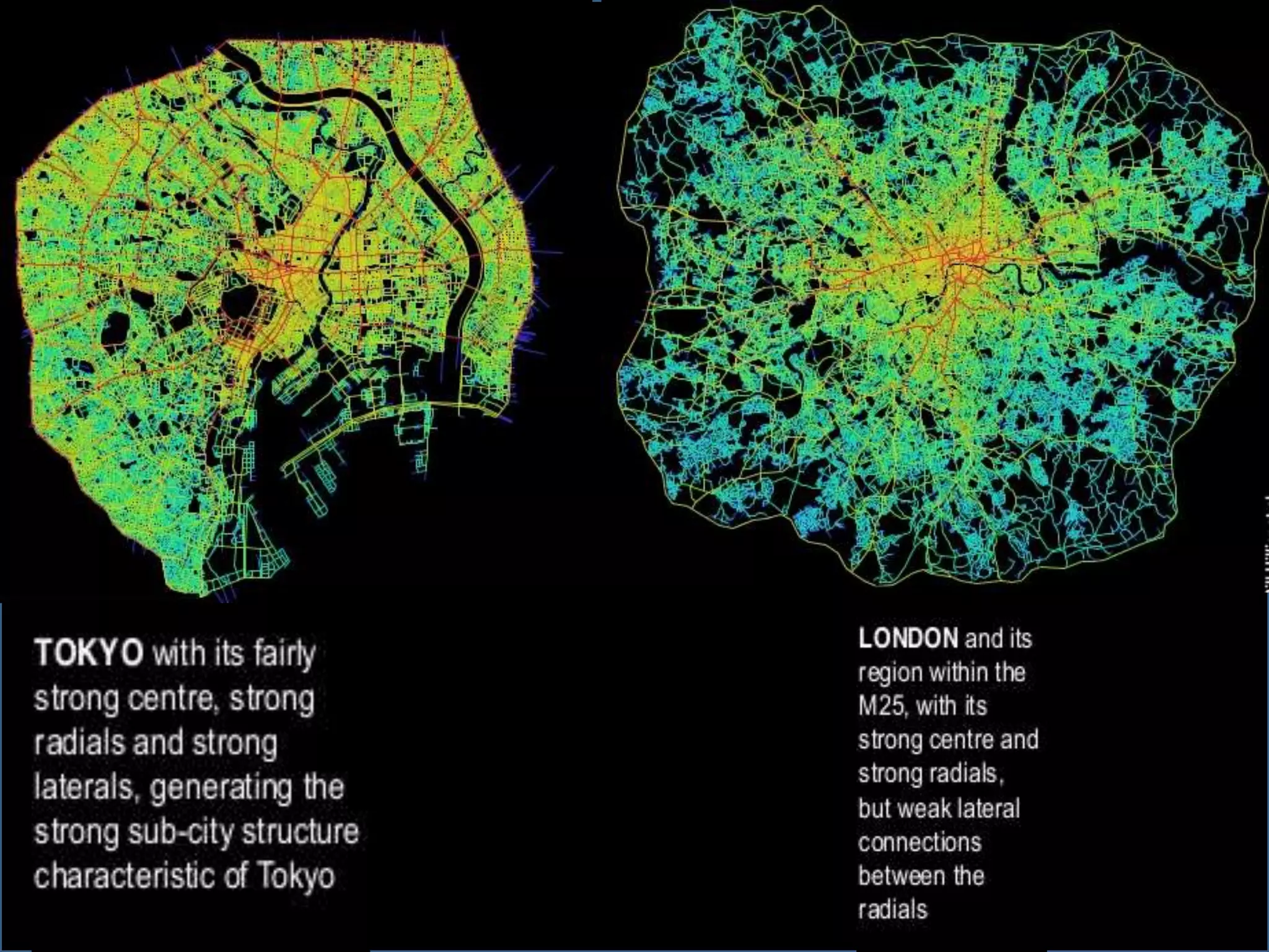
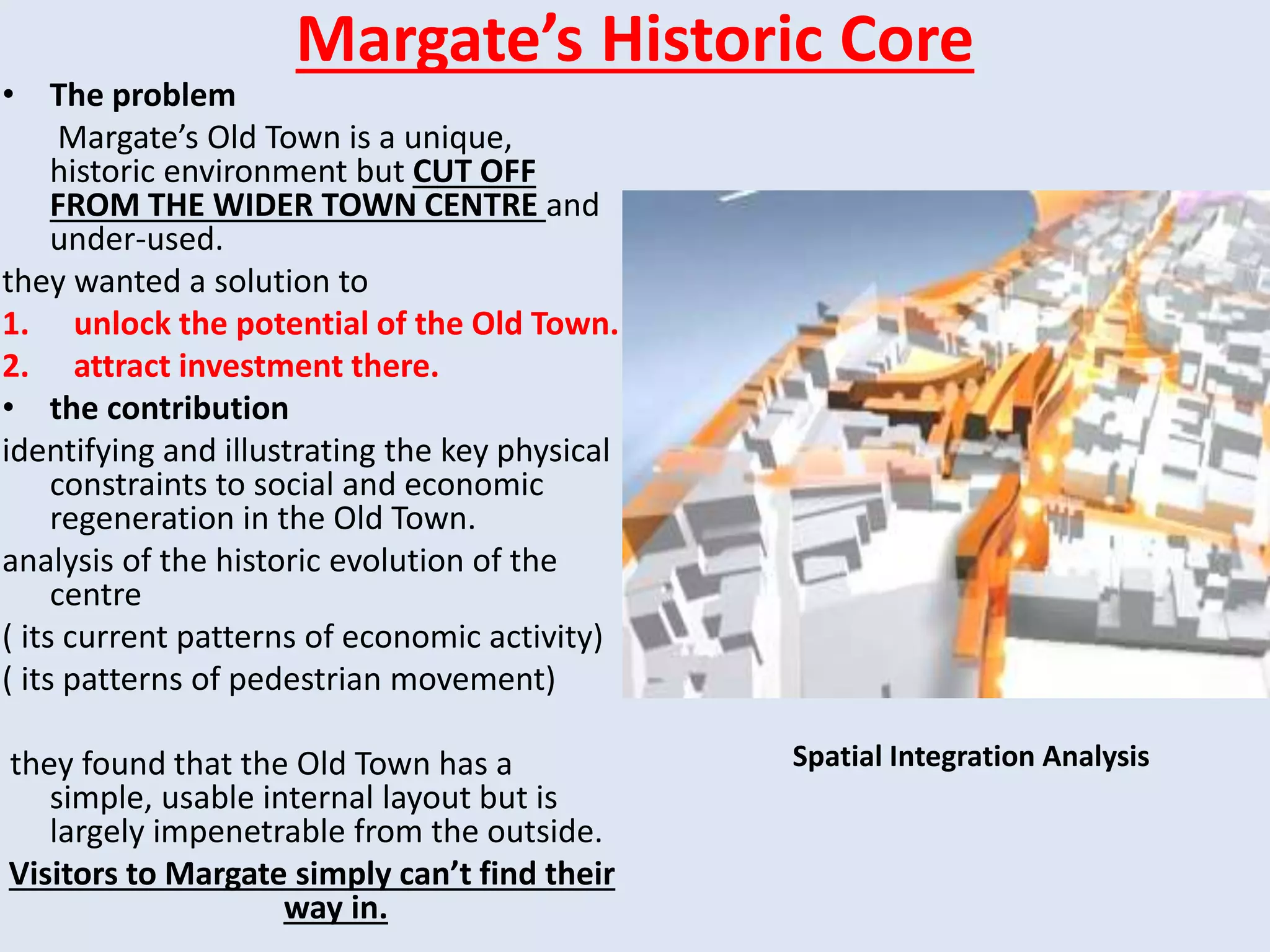
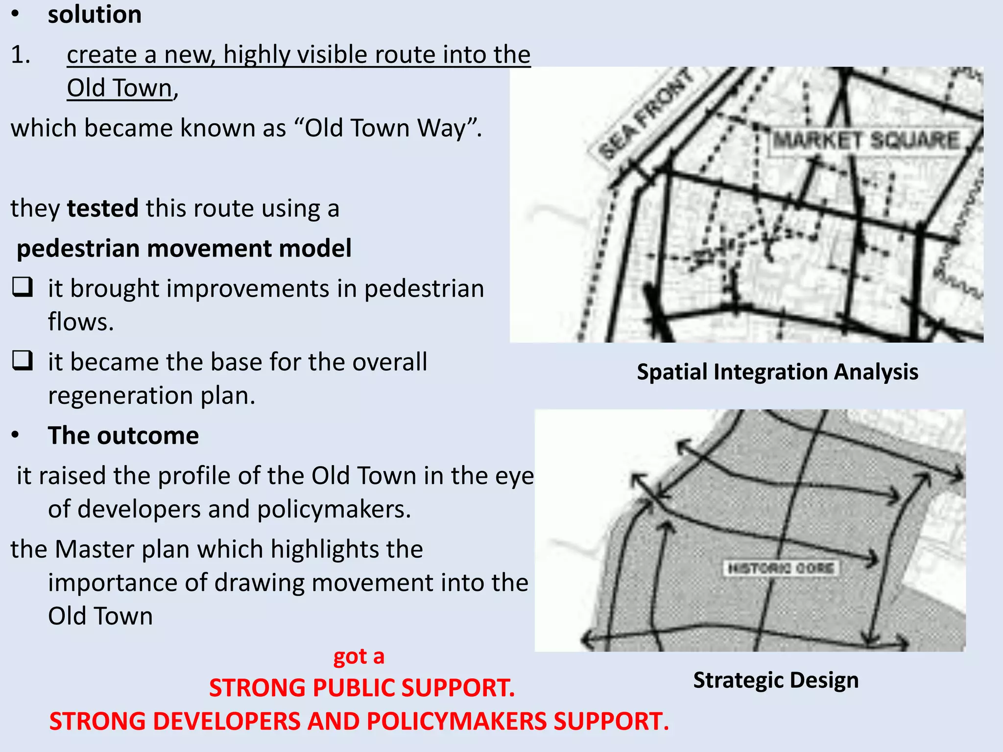
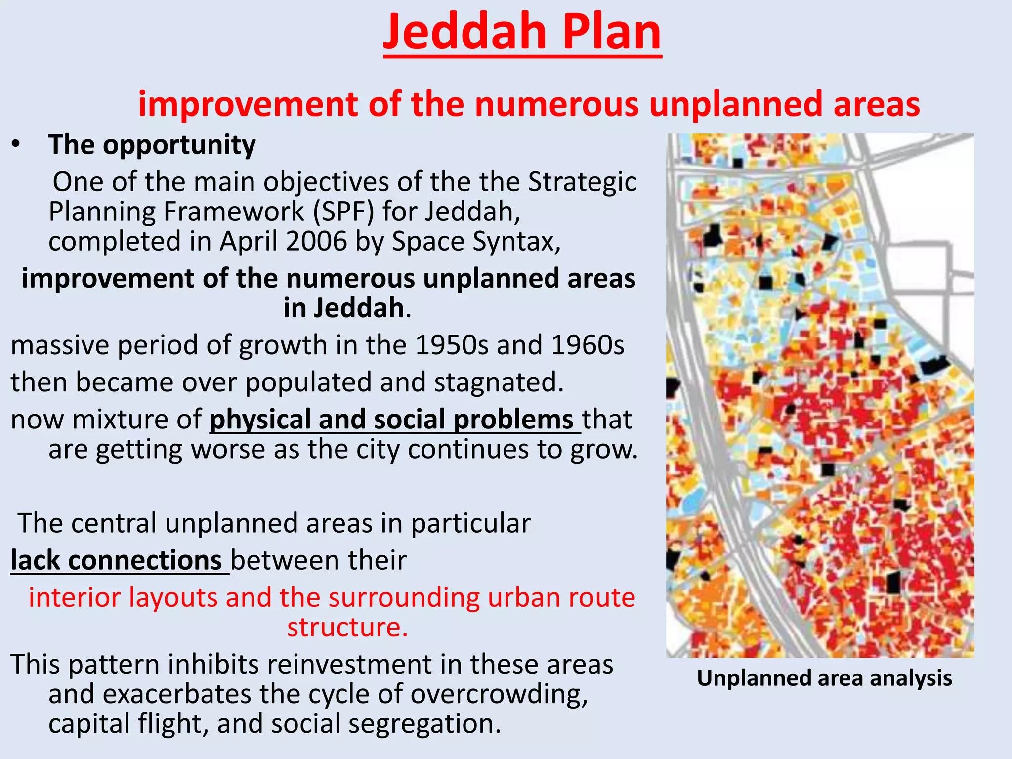
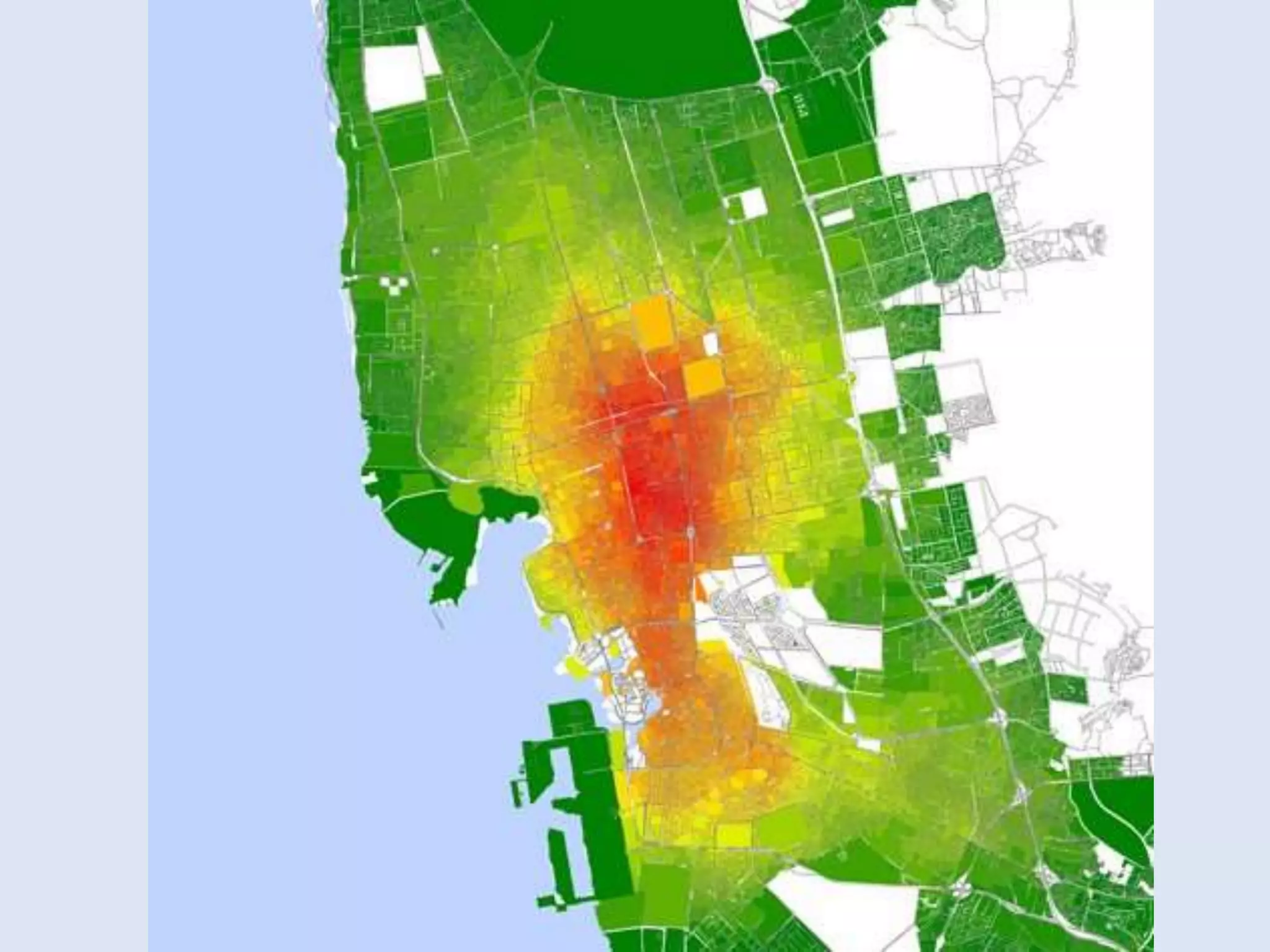
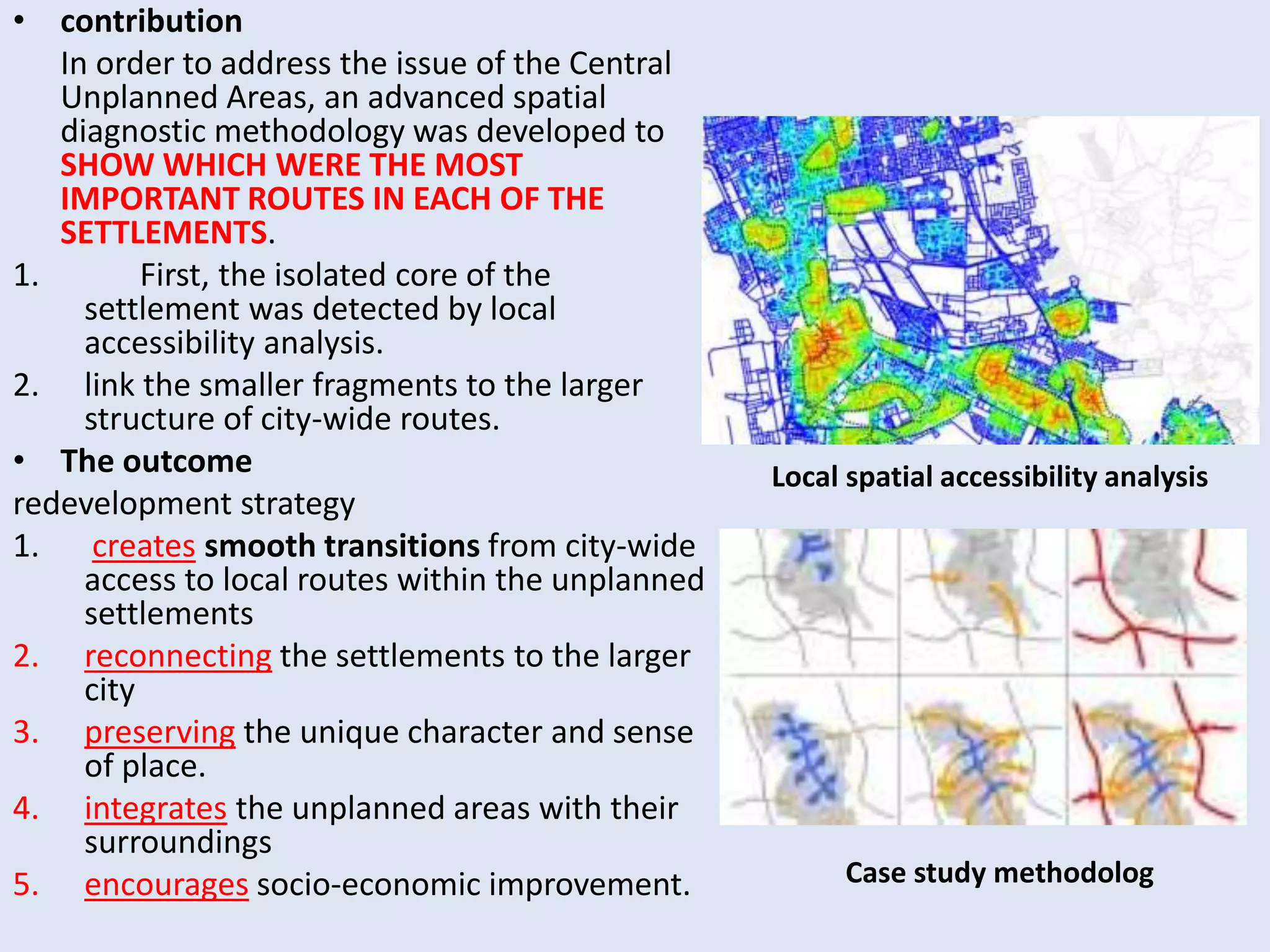
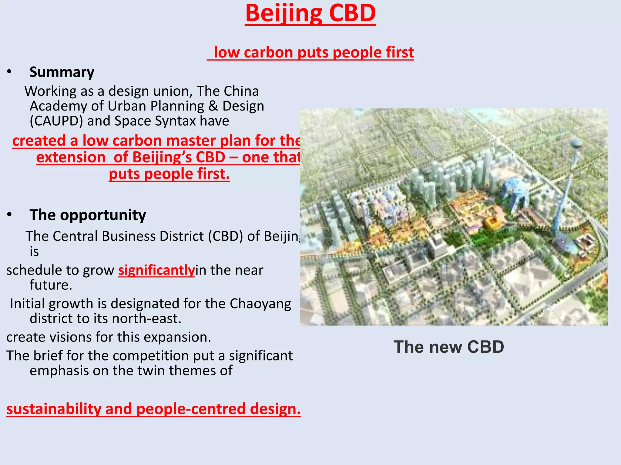
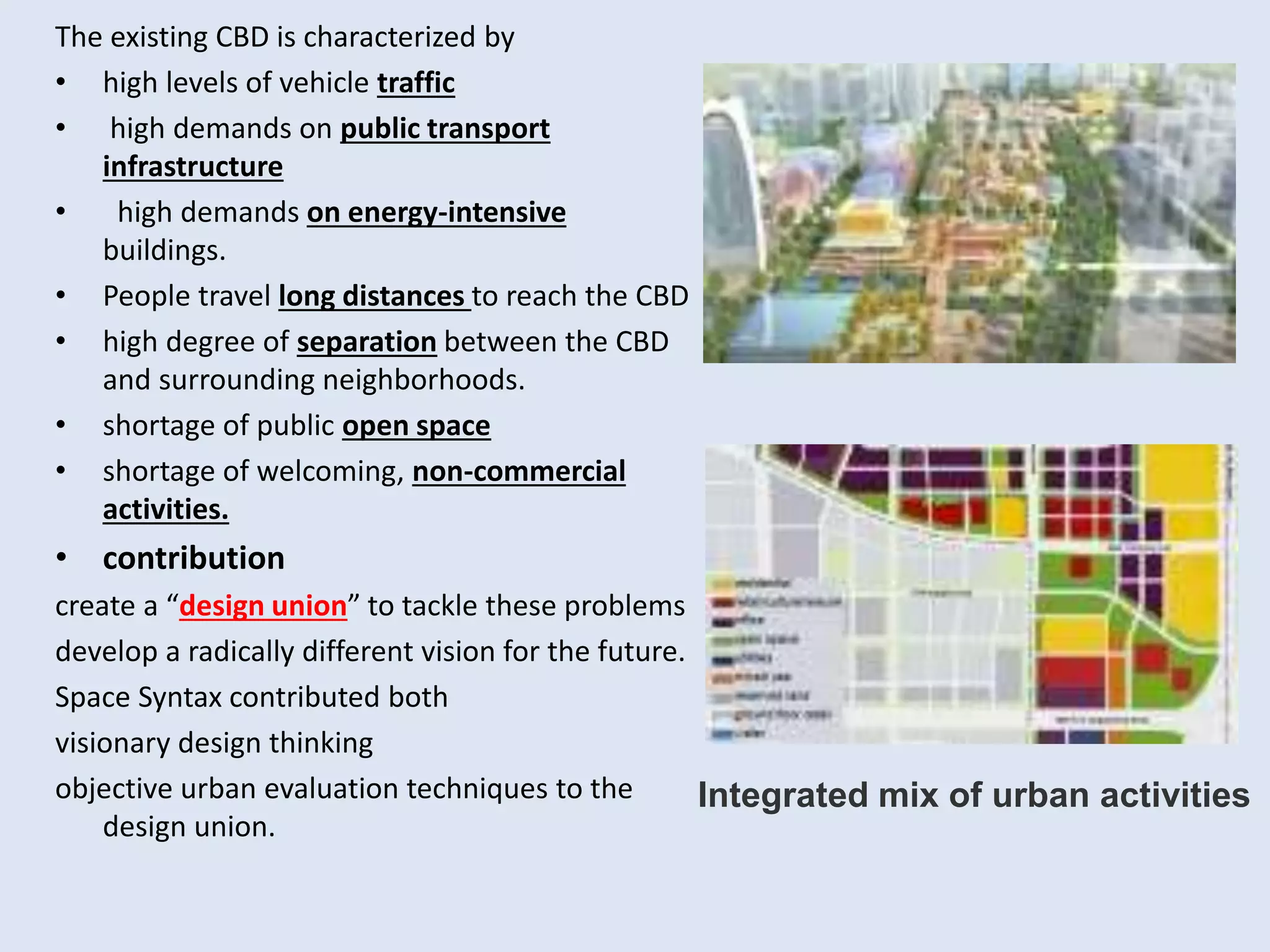
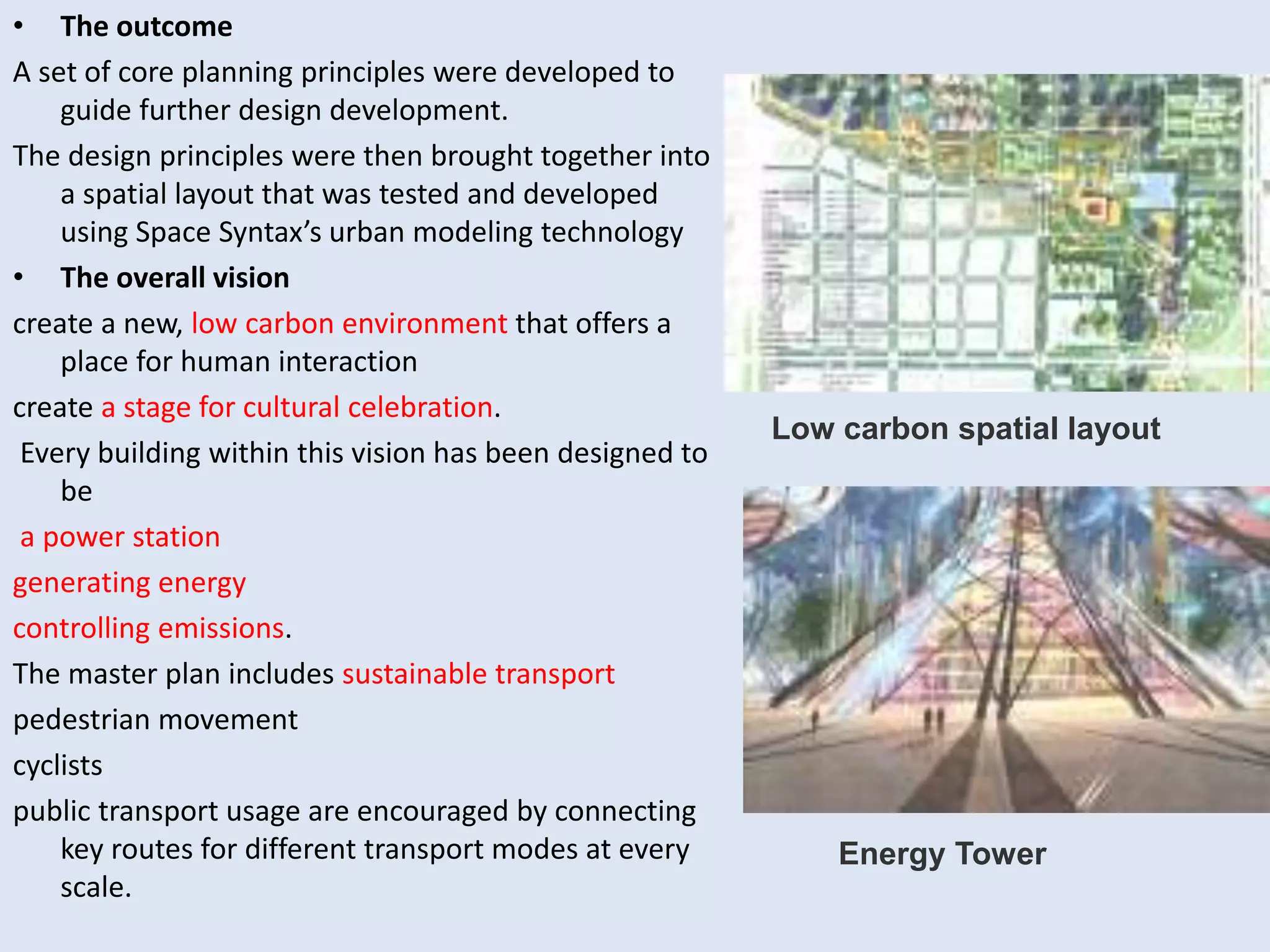
SPACE SYNTAX
Prepared by: maram foad obaidat
shomoo aljizawi .
Supervised by: Dr. Imad Al-Hashimi.
Contents:
1- Introduction.
2- Space syntax history.
3- Definitions.
4- Space Syntax Application.
5- Space Syntax Keys.
6- Theory and Analysis.
7- Syntactic Maps.
8- Syntactic Measures.
9- The Case Studies.
Introduction:
• A well-known aphorism by
Winston Churchill
• We shape our buildings, and after
wards our buildings shape us.
‘’ A comparable belief in the influence
of buildings and more generally of
the built environment on humans is
common in architectural and urban
thinking.
• the spaces are understood as
VOIDS (streets, squares, rooms,
fields, etc
that restrain PEDESTRIAN traffic
and/or the visual field.
Space syntax History:
• 1970s by
Prof Bill Hiller
Prof Julienne Hanson
colleagues at The Bartlett, University
college London.
• Today, space syntax is
used and developed in hundreds of
universities and educational institutions
used as professional practices worldwide.
Built on quantitative analysis
geospatial computer technology,
it provides a set of theories and methods
for the analysis of spatial configurations
of all kinds and at all scales.
Definitions:
• The space syntax approach was
conceived to help architects
simulate the likely effects of their
designs on the people who
occupied and moved around in
them, by their buildings or urban
settlements.
• These phenomena include
 patterns of movement
 awareness
 interaction
 Density
 land use
 land value
 urban growth
 societal differentiation
 safety
 crime distribution
• design applications in architecture, urban design,
planning, transport and interior design.
Space syntax ...
is a set of techniques for
representation
Quantification
interpretation of spatial configuration in
buildings and settlements.
Configuration is defined in general as,
at least, the relation between two
spaces taking into account a third,
and, at most, as the relations among
spaces in a complex taking into
account all other spaces in the
complex.
• Space Syntax’s unique contribution
to the field of urban planning and
design is in the identification of
fundamental links between
spatial layout and the social, economic and environmental performance of
places.
Space Syntax
Applications
Criminology
Archaeology
Information
technology
Urban and
human
geography
Anthropology
Cognitive
science
Space Syntax Keys:
• Space Syntax research has made five key discoveries that
demonstrate how spatial layout directly affects:
- movement, such that Space Syntax models can be used as
strategic traffic modeling tools for vehicle, pedestrian and
cycling movement
- land use, showing how land use performance is deeply
influenced by spatial location
- safety, allowing risk to be identified and safer places to be
created
- land value, demonstrating the influence of spatial networks
on property economics
- carbon emissions, highlighting the contribution of spatial
planning and design to environmental impact.
Theory and Analysis :
• The general idea is that
1. spaces can be broken down into components
2. analyzed as networks of choices
3. represented as maps and graphs that describe the
relative connectivity and integration of those spaces. It
rests on three basic conceptions of space:
Axial
space
convex
space
Isovit
is a space where no line
between any two of its
points crosses the perimeter.
axial line is a straight line
possible to follow on foot.
space is the total area that
can be viewed from a point.
Three types of syntactic maps:
• Convex map
depicts the least number of convex spaces
that fully cover a layout and the
connections between them.
• Axial map
depicts the least number of axial
lines covering all convex spaces of
a layout and their connections.
• Isovist map
the volume of space visible from convex spaces or axial
lines.
Syntactic measures:
Connectivity
measures the number of immediate neighbors that are directly
connected to a space. This is a static local measure.
They are used in quantitative representations of building and urban layouts:
Integration
is a static global measure.
It describes the average depth of a space to all other
spaces in the system.
It describes how easy it is to get to one segment from
all other segments.
Control value
is a dynamic local measure. It measures the degree to which a
space controls access to its immediate neighbors taking into
account the number of alternative connections that each of these
neighbors has.
Global choice
is a dynamic global measure of the “flow” through a space. A
space has a strong choice value when many of the shortest paths,
connecting all spaces to all spaces of a system, passes through it.
THE CASE STUDIES
Margate’s Historic Core
• The problem
Margate’s Old Town is a unique,
historic environment but CUT OFF
FROM THE WIDER TOWN CENTRE and
under-used.
they wanted a solution to
1. unlock the potential of the Old Town.
2. attract investment there.
• the contribution
identifying and illustrating the key physical
constraints to social and economic
regeneration in the Old Town.
analysis of the historic evolution of the
centre
( its current patterns of economic activity)
( its patterns of pedestrian movement)
they found that the Old Town has a
simple, usable internal layout but is
largely impenetrable from the outside.
Visitors to Margate simply can’t find their
way in.
Spatial Integration Analysis
• solution
1. create a new, highly visible route into the
Old Town,
which became known as “Old Town Way”.
they tested this route using a
pedestrian movement model
 it brought improvements in pedestrian
flows.
 it became the base for the overall
regeneration plan.
• The outcome
it raised the profile of the Old Town in the eyes
of developers and policymakers.
the Master plan which highlights the
importance of drawing movement into the
Old Town
Spatial Integration Analysis
Strategic Design
got a
STRONG PUBLIC SUPPORT.
STRONG DEVELOPERS AND POLICYMAKERS SUPPORT.
Jeddah Plan
improvement of the numerous unplanned areas
• The opportunity
One of the main objectives of the the Strategic
Planning Framework (SPF) for Jeddah,
completed in April 2006 by Space Syntax,
improvement of the numerous unplanned areas
in Jeddah.
massive period of growth in the 1950s and 1960s
then became over populated and stagnated.
now mixture of physical and social problems that
are getting worse as the city continues to grow.
The central unplanned areas in particular
lack connections between their
interior layouts and the surrounding urban route
structure.
This pattern inhibits reinvestment in these areas
and exacerbates the cycle of overcrowding,
capital flight, and social segregation.
Unplanned area analysis
Jeddah Plan
• contribution
In order to address the issue of the Central
Unplanned Areas, an advanced spatial
diagnostic methodology was developed to
SHOW WHICH WERE THE MOST
IMPORTANT ROUTES IN EACH OF THE
SETTLEMENTS.
1. First, the isolated core of the
settlement was detected by local
accessibility analysis.
2. link the smaller fragments to the larger
structure of city-wide routes.
• The outcome
redevelopment strategy
1. creates smooth transitions from city-wide
access to local routes within the unplanned
settlements
2. reconnecting the settlements to the larger
city
3. preserving the unique character and sense
of place.
4. integrates the unplanned areas with their
surroundings
5. encourages socio-economic improvement.
Local spatial accessibility analysis
Case study methodolog
Beijing CBD
low carbon puts people first
• Summary
Working as a design union, The China
Academy of Urban Planning & Design
(CAUPD) and Space Syntax have
created a low carbon master plan for the
extension of Beijing’s CBD – one that
puts people first.
• The opportunity
The Central Business District (CBD) of Beijing
is
schedule to grow significantlyin the near
future.
Initial growth is designated for the Chaoyang
district to its north-east.
create visions for this expansion.
The brief for the competition put a significant
emphasis on the twin themes of
sustainability and people-centred design.
The new CBD
The existing CBD is characterized by
• high levels of vehicle traffic
• high demands on public transport
infrastructure
• high demands on energy-intensive
buildings.
• People travel long distances to reach the CBD
• high degree of separation between the CBD
and surrounding neighborhoods.
• shortage of public open space
• shortage of welcoming, non-commercial
activities.
• contribution
create a “design union” to tackle these problems
develop a radically different vision for the future.
Space Syntax contributed both
visionary design thinking
objective urban evaluation techniques to the
design union.
Integrated mix of urban activities
• The outcome
A set of core planning principles were developed to
guide further design development.
The design principles were then brought together into
a spatial layout that was tested and developed
using Space Syntax’s urban modeling technology
• The overall vision
create a new, low carbon environment that offers a
place for human interaction
create a stage for cultural celebration.
Every building within this vision has been designed to
be
a power station
generating energy
controlling emissions.
The master plan includes sustainable transport
pedestrian movement
cyclists
public transport usage are encouraged by connecting
key routes for different transport modes at every
scale.
Low carbon spatial layout
Energy Tower
Thank you

Space syntax

  • 1.
    SPACE SYNTAX Prepared by:maram foad obaidat shomoo aljizawi . Supervised by: Dr. Imad Al-Hashimi.
  • 2.
    Contents: 1- Introduction. 2- Spacesyntax history. 3- Definitions. 4- Space Syntax Application. 5- Space Syntax Keys. 6- Theory and Analysis. 7- Syntactic Maps. 8- Syntactic Measures. 9- The Case Studies.
  • 3.
    Introduction: • A well-knownaphorism by Winston Churchill • We shape our buildings, and after wards our buildings shape us. ‘’ A comparable belief in the influence of buildings and more generally of the built environment on humans is common in architectural and urban thinking. • the spaces are understood as VOIDS (streets, squares, rooms, fields, etc that restrain PEDESTRIAN traffic and/or the visual field.
  • 4.
    Space syntax History: •1970s by Prof Bill Hiller Prof Julienne Hanson colleagues at The Bartlett, University college London. • Today, space syntax is used and developed in hundreds of universities and educational institutions used as professional practices worldwide. Built on quantitative analysis geospatial computer technology, it provides a set of theories and methods for the analysis of spatial configurations of all kinds and at all scales.
  • 5.
    Definitions: • The spacesyntax approach was conceived to help architects simulate the likely effects of their designs on the people who occupied and moved around in them, by their buildings or urban settlements. • These phenomena include  patterns of movement  awareness  interaction  Density  land use  land value  urban growth  societal differentiation  safety  crime distribution
  • 6.
    • design applicationsin architecture, urban design, planning, transport and interior design.
  • 8.
    Space syntax ... isa set of techniques for representation Quantification interpretation of spatial configuration in buildings and settlements. Configuration is defined in general as, at least, the relation between two spaces taking into account a third, and, at most, as the relations among spaces in a complex taking into account all other spaces in the complex. • Space Syntax’s unique contribution to the field of urban planning and design is in the identification of fundamental links between spatial layout and the social, economic and environmental performance of places.
  • 9.
  • 10.
    Space Syntax Keys: •Space Syntax research has made five key discoveries that demonstrate how spatial layout directly affects: - movement, such that Space Syntax models can be used as strategic traffic modeling tools for vehicle, pedestrian and cycling movement - land use, showing how land use performance is deeply influenced by spatial location - safety, allowing risk to be identified and safer places to be created - land value, demonstrating the influence of spatial networks on property economics - carbon emissions, highlighting the contribution of spatial planning and design to environmental impact.
  • 11.
    Theory and Analysis: • The general idea is that 1. spaces can be broken down into components 2. analyzed as networks of choices 3. represented as maps and graphs that describe the relative connectivity and integration of those spaces. It rests on three basic conceptions of space: Axial space convex space Isovit is a space where no line between any two of its points crosses the perimeter. axial line is a straight line possible to follow on foot. space is the total area that can be viewed from a point.
  • 12.
    Three types ofsyntactic maps: • Convex map depicts the least number of convex spaces that fully cover a layout and the connections between them. • Axial map depicts the least number of axial lines covering all convex spaces of a layout and their connections.
  • 13.
    • Isovist map thevolume of space visible from convex spaces or axial lines.
  • 14.
    Syntactic measures: Connectivity measures thenumber of immediate neighbors that are directly connected to a space. This is a static local measure. They are used in quantitative representations of building and urban layouts:
  • 15.
    Integration is a staticglobal measure. It describes the average depth of a space to all other spaces in the system. It describes how easy it is to get to one segment from all other segments.
  • 16.
    Control value is adynamic local measure. It measures the degree to which a space controls access to its immediate neighbors taking into account the number of alternative connections that each of these neighbors has. Global choice is a dynamic global measure of the “flow” through a space. A space has a strong choice value when many of the shortest paths, connecting all spaces to all spaces of a system, passes through it.
  • 19.
  • 20.
    Margate’s Historic Core •The problem Margate’s Old Town is a unique, historic environment but CUT OFF FROM THE WIDER TOWN CENTRE and under-used. they wanted a solution to 1. unlock the potential of the Old Town. 2. attract investment there. • the contribution identifying and illustrating the key physical constraints to social and economic regeneration in the Old Town. analysis of the historic evolution of the centre ( its current patterns of economic activity) ( its patterns of pedestrian movement) they found that the Old Town has a simple, usable internal layout but is largely impenetrable from the outside. Visitors to Margate simply can’t find their way in. Spatial Integration Analysis
  • 21.
    • solution 1. createa new, highly visible route into the Old Town, which became known as “Old Town Way”. they tested this route using a pedestrian movement model  it brought improvements in pedestrian flows.  it became the base for the overall regeneration plan. • The outcome it raised the profile of the Old Town in the eyes of developers and policymakers. the Master plan which highlights the importance of drawing movement into the Old Town Spatial Integration Analysis Strategic Design got a STRONG PUBLIC SUPPORT. STRONG DEVELOPERS AND POLICYMAKERS SUPPORT.
  • 22.
    Jeddah Plan improvement ofthe numerous unplanned areas • The opportunity One of the main objectives of the the Strategic Planning Framework (SPF) for Jeddah, completed in April 2006 by Space Syntax, improvement of the numerous unplanned areas in Jeddah. massive period of growth in the 1950s and 1960s then became over populated and stagnated. now mixture of physical and social problems that are getting worse as the city continues to grow. The central unplanned areas in particular lack connections between their interior layouts and the surrounding urban route structure. This pattern inhibits reinvestment in these areas and exacerbates the cycle of overcrowding, capital flight, and social segregation. Unplanned area analysis
  • 23.
  • 24.
    • contribution In orderto address the issue of the Central Unplanned Areas, an advanced spatial diagnostic methodology was developed to SHOW WHICH WERE THE MOST IMPORTANT ROUTES IN EACH OF THE SETTLEMENTS. 1. First, the isolated core of the settlement was detected by local accessibility analysis. 2. link the smaller fragments to the larger structure of city-wide routes. • The outcome redevelopment strategy 1. creates smooth transitions from city-wide access to local routes within the unplanned settlements 2. reconnecting the settlements to the larger city 3. preserving the unique character and sense of place. 4. integrates the unplanned areas with their surroundings 5. encourages socio-economic improvement. Local spatial accessibility analysis Case study methodolog
  • 25.
    Beijing CBD low carbonputs people first • Summary Working as a design union, The China Academy of Urban Planning & Design (CAUPD) and Space Syntax have created a low carbon master plan for the extension of Beijing’s CBD – one that puts people first. • The opportunity The Central Business District (CBD) of Beijing is schedule to grow significantlyin the near future. Initial growth is designated for the Chaoyang district to its north-east. create visions for this expansion. The brief for the competition put a significant emphasis on the twin themes of sustainability and people-centred design. The new CBD
  • 26.
    The existing CBDis characterized by • high levels of vehicle traffic • high demands on public transport infrastructure • high demands on energy-intensive buildings. • People travel long distances to reach the CBD • high degree of separation between the CBD and surrounding neighborhoods. • shortage of public open space • shortage of welcoming, non-commercial activities. • contribution create a “design union” to tackle these problems develop a radically different vision for the future. Space Syntax contributed both visionary design thinking objective urban evaluation techniques to the design union. Integrated mix of urban activities
  • 27.
    • The outcome Aset of core planning principles were developed to guide further design development. The design principles were then brought together into a spatial layout that was tested and developed using Space Syntax’s urban modeling technology • The overall vision create a new, low carbon environment that offers a place for human interaction create a stage for cultural celebration. Every building within this vision has been designed to be a power station generating energy controlling emissions. The master plan includes sustainable transport pedestrian movement cyclists public transport usage are encouraged by connecting key routes for different transport modes at every scale. Low carbon spatial layout Energy Tower
  • 28.