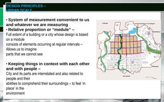
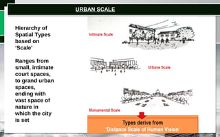
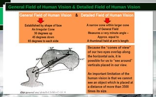
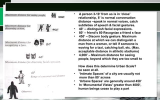
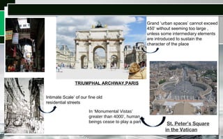
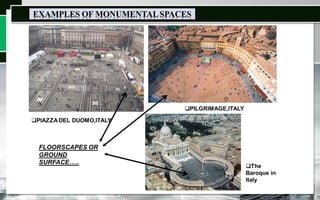
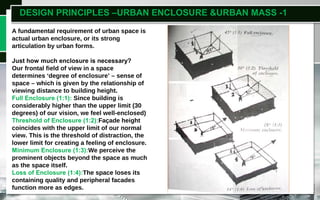
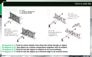
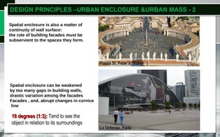
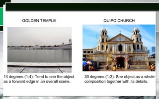
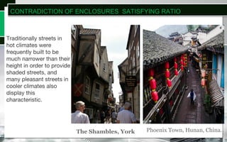
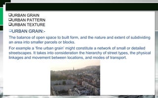
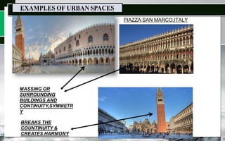
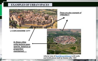
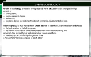
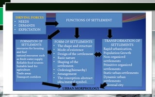
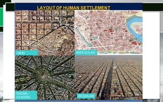
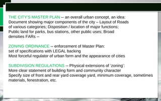
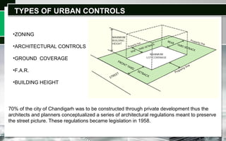
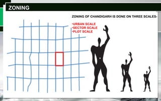
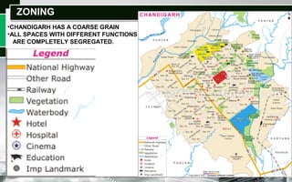
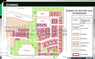
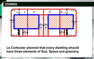
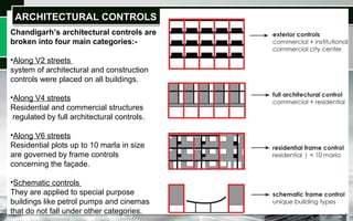
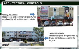
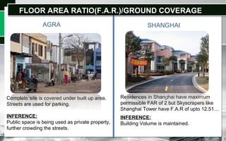
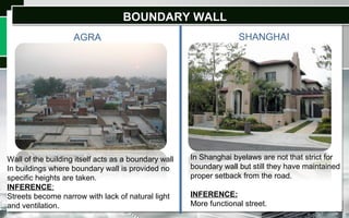
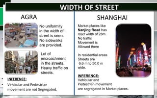
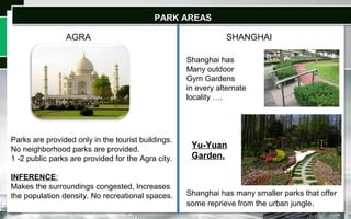
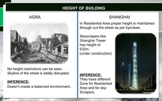
RIMT-COA
SIRHIND SIDE
MANDI GOBINDGARH
BACH-803
URBAN DESIGN-I
PRINCIPLES,DEVELOPMENT
CONTROLS,ROLE &IMPORTANCE
CONTENTS
 INTRODUCTION
 ROLE OF URBAN
DESIGN
 DESIGN PRINCIPLES
• SCALE
• ENCLOSURE & MASS
• URBAN PATTERN
• URBAN TEXTURE
• URBAN GRAIN
• CONTRAST
• URBAN MORPHOLOGY
 URBAN CONTROLS
 CHANDIGARH
 COMPARISION
INTRODUCTION
Urban design deals with the larger scale of groups of buildings, streets and public
spaces, whole neighborhoods and districts, and entire cities, with the goal of making
urban areas functional, attractive, and sustainable.
Urban design theory deals primarily with the design and management of public
space and the way public places are experienced and used. Public space includes
the totality of spaces used freely on a day-to-day basis by the general public, such
as streets, plazas, parks and public infrastructure.
WHAT IS URBAN DESIGN?
arrangement, appearance & functionality
of towns and cities, especially,
shaping and uses of urban public space.
ROLE OF URBAN DESIGN SHAPING AND USES OF PUBLIC SPACE
Urban Design Theory deals primarily with “Design and Management of Public
& Public Places are experienced Public Space -- 'environment',
the way and used.
Some aspects of privately owned
spaces,such as building facades or
domestic gardens, also contribute to
public space and are, therefore, also
considered by Urban Design Theory.
public environment ,
'public realm' or 'public domain‘ --
includes all manners of spaces used
freely on a day-to-day basis by the
general public --streets, plazas, parks..
DESIGN PRINCIPLES –
URBAN SCALE
WHAT IS ‘SCALE’?
• System of measurement convenient to us
and whatever we are measuring
• Relative proportion or “module” –
Full extent of a building or a city whose design is based
on a module
consists of elements occurring at regular intervals –
Allows us to imagine
parts that we cannot see
• Keeping things in context with each other
and with people –
City and its parts are interrelated and also related to
people and their
abilities to comprehend their surroundings – to feel ‘in
place’ in the
environment
Hierarchy of
Spatial Types
based on
‘Scale’
Ranges from
small, intimate
court spaces,
to grand urban
spaces,
ending with
vast space of
nature in
which the city
is set
URBAN SCALE
General Field of Human Vision & Detailed Field of Human Vision
• A person 3-10’ from us is in ‘close’
relationship, 8’ is normal conversation
distance –speak in normal voices, catch
subtleties of speech & facial gestures.
• 40’ -- distinguish facial expressions.
• 80’ – friend’s 80 Recognize a friend s face
• 450’ – Discern body gesture. Maximum
distance at which we can distinguish a
man from a woman, or tell if someone is
waving for a taxi, catching ball, etc. (Max.
acceptable distance in athletic stadiums)
• 4,000’ – Maximum distance for seeing
people, beyond which they are too small to
How does this determine Urban Scale?
be seen at all.
• ‘Intimate Spaces’ of a city are usually not
more than 80’ across
• ‘Urbane Spaces’ are generally around 450’
• In ‘Monumental Vistas’ greater than 4000’,
human beings cease to play a part
Grand ‘urban spaces’ cannot exceed
450’ without seeming too large ,
unless some intermediary elements
are introduced to sustain the
character of the place
Intimate Scale’ of our fine old
residential streets
In ‘Monumental Vistas’
greater than 4000’, human
beings cease to play a part
TRIUMPHAL ARCHWAY,PARIS
 St. Peter’s Square
in the Vatican
DESIGN PRINCIPLES –URBAN ENCLOSURE &URBAN MASS -1
A fundamental requirement of urban space is
actual urban enclosure, or its strong
articulation by urban forms.
Just how much enclosure is necessary?
Our frontal field of view in a space
determines ‘degree of enclosure’ – sense of
space – which is given by the relationship of
viewing distance to building height.
Full Enclosure (1:1): Since building is
considerably higher than the upper limit (30
degrees) of our vision, we feel well-enclosed)
Threshold of Enclosure (1:2):Façade height
coincides with the upper limit of our normal
view. This is the threshold of distraction, the
lower limit for creating a feeling of enclosure.
Minimum Enclosure (1:3):We perceive the
prominent objects beyond the space as much
as the space itself.
Loss of Enclosure (1:4):The space loses its
containing quality and peripheral facades
function more as edges.
Click to add title
45 degrees (1:1):Tend to notice details more than the whole facade or object
30 degrees (1:2): See object as a whole composition together with its details.
18 degrees (1:3):Tend to see the object in relation to its surroundings.
14 degrees (1:4):Tend to see the object as a forward edge in an overall scene.
Click to add titleSpatial enclosure is also a matter of
continuity of wall surface:
the role of building facades must be
subservient to the spaces they form.
Spatial enclosure can be weakened
by too many gaps in building walls,
drastic variation among the facades
Facades , and, abrupt changes in cornice
line
DESIGN PRINCIPLES –URBAN ENCLOSURE &URBAN MASS - 2
18 degrees (1:3):18 degrees (1:3): Tend to see the
object in relation to its surroundings
14 degrees (1:4): Tend to see the object
as a forward edge in an overall scene.
QUIPO CHURCHGOLDEN TEMPLE
30 degrees (1:2): See object as a whole
composition together with its details.
Traditionally streets in
hot climates were
frequently built to be
much narrower than their
height in order to provide
shaded streets, and
many pleasant streets in
cooler climates also
display this
characteristic.
Phoenix Town, Hunan, China.The Shambles, York
CONTRADICTION OF ENCLOSURES SATISFYING RATIO
URBAN GRAIN
URBAN PATTERN
URBAN TEXTURE
URBAN GRAIN:-
The balance of open space to built form, and the nature and extent of subdividing
an area into smaller parcels or blocks.
For example a ‘fine urban grain’ might constitute a network of small or detailed
streetscapes. It takes into consideration the hierarchy of street types, the physical
linkages and movement between locations, and modes of transport.
Urban grain refers to the street pattern, block sizes and building pattern within a city
and describes the interrelationship between these elements.
A fine urban grain is highly desired to create a precinct which is as inviting and
approachable as possible to visitors.
The Design must balance high quality permanent landscape with flexible, well-
designed urban spaces that can continually change and support a variety of
activities and events and draw an increased number of visitors to the site.
FINE GRAIN
COURSE GRAIN
Grain is fine when similar elements or functions are widely dispersed throughout the
district without forming any large clusters. On the other hand, grain is coarse if
different elements and functions are segregated from each other in a way that
extensive areas of one thing are separated from extensive areas of other things
URBAN PATTERN
The pattern of the city is the way how
different functions and elements of the
settlement form are distributed and mixed
together spatially. It can be measured by
the size of its grain.
The design pattern in the city’s outer
neighborhoods is less formal than it is in
the heart of the city. Their image is defined
more by architecture, scale, tree cover, and
topography than it is by monumental vistas.
IT CAN BE OF DIFFERENT TYPES:-
RADIAL PATTERN
GRID PATTERN
LINEAR PATTERN
Urban texture usually refers to the urban space patterns which include the urban
space structure and the arrangement of its related factors .
At beginning phase, urban texture was used as a method of analyzing space and
its importance was subsequently realized in urban historic preservation, urban
design, and urban landscape studies.
At the macroscale, urban texture examines the main urban landscape
characteristics of a city.
At the microscale, urban texture underlines the interrelations of land-use, block,
and street layouts, which are the physical expressions of urban evolution.
PATTERNS CAN BE EVEN AND UNEVEN PATTERNS.
URBAN TEXTURE
URBAN TEXTURE
EXAMPLE OF BARCELONA
PIAZZA SAN MARCO,ITALY
Urban Morphology is the study of the physical form of a city, which, among other things,
consists of
o street patterns,
o building sizes and shapes,
o architecture,
o population density and patterns of residential, commercial, industrial and other uses,
Urban morphology is, thus, the study of urban tissue, or urban fabric, in order to discern and analyse
o the basic structure of the built landscape,
o the manner in which social forms are expressed in the physical layout of a city, and
conversely, how physical form of a city can produce various social forms
o how the physical form of a city changes over time
o how different cities compare to each other
URBAN MORPHOLOGY
WHAT ARE ‘URBAN CONTROLS’
At no stage in the growth of a human
settlement can one
predict its total or ultimate form –
development takes place in
space and time, and, is subject to social,
economic, political,
technological , and, several other stresses
The Purpose of “Urban Controls” or
“Urban Regulatory
Measures” is, thus, to create a system of
development that
will permit the realization of form in which
an urban settlement
is conceived, and, which will give the
designers’ hand the
strength of law.
DEVELOPMENT OF REGULATORY MEASURES
•Formal Beginning around mid-19th century
•Instituted to clarify boundaries of ‘public’ and ‘private’ domain –
•Social, health and safety requirements began to be major regulators of
urban form (Adoption of Housing Codes, Regulations for fire prevention,
etc.)
IMPORTANT LAWS / DATES LAWS / DATES
•1916 – Pioneering ‘Zoning Laws’ in New York - Necessitated by threat
to property values posed by 40-storey Equitable Building that cut off
light and air from its adjoining plots Led to the ‘Zoning’ / public
regulations ensuring adequate light and air
•1926 – Standard Enabling Legislation” – empowered state city
governments to prepare zoning plans, etc.
•1954 – Supreme Court of decided that aesthetics was a just public
concern worthy of support by law.
ELEMENTS AFFECTED BY URBAN CONTROLS:
Urban Controls affect anything that plays a role or role, or, occurs in the design of
the ‘public realm’ – i.e., spaces as well as objects in space –
•Constructed Volumes ( individual & occurring in groups). Features affected form,
scale, skyline, spatial setting, façade, materials, colour, etc.
•Open Spaces / Urban Spaces: Features affected – Scale, degree of
enclosure, surface contour, floorscape, landscaping, street furniture
•Circulation Channels: Features affected – size, right-of-way, flanking
buildings, trees, hoardings, and, all such elements seem on or from such
channels
•Public Services, including electric supply lines, telephone lines, drainage,
water supply, etc. and the manner of taking connections from the public
supply lines to private / individual property
THE CITY’S MASTER PLAN -- an overall urban concept, an idea:
Document showing major components of the city – Layout of Roads
of various categories; Disposition / location of major functions;
Public land for parks, bus stations, other public uses; Broad
densities FARs --
ZONING ORDINANCE -- enforcement of Master Plan:
set of specifications with LEGAL backing
Most forceful regulator of urban form and the appearance of cities
SUBDIVISION REGULATIONS -- Physical extensions of ‘zoning’:
More clear statement of building form and community character
Specify size of front and rear yard coverage yard, minimum coverage, sometimes
materials, fenestration, etc.
EFFECT OF SOME EVENTS --
•Civic Defence required construction of defensive wall –
regulated physical limits to city
•Control on sale of land to inhabitants
generally led to grid layouts
Before 19th century No control on actual use of land
As city developed and became more dense – it became important
to clarify the difference between the ‘public’ and ‘private’ domain
Right-of-way for traffic
Operation of a police and fire system
Sewage disposal, water supply…
Social requirements began to be major regulators of urban form
Government tasks
Mid -19th century
TYPES OF URBAN CONTROLSTYPES OF URBAN CONTROLS
•ZONING
•ARCHITECTURAL CONTROLS
•GROUND COVERAGE
•F.A.R.
•BUILDING HEIGHT
70% of the city of Chandigarh was to be constructed through private development thus the
architects and planners conceptualized a series of architectural regulations meant to preserve
the street picture. These regulations became legislation in 1958.
ZONINGZONING
ZONING OF CHANDIGARH IS DONE ON THREE SCALES-
•URBAN SCALE
•SECTOR SCALE
•PLOT SCALE
ZONINGZONING
•CHANDIGARH HAS A COARSE GRAIN
•ALL SPACES WITH DIFFERENT FUNCTIONS
ARE COMPLETELY SEGREGATED.
ZONINGZONING
ZONING OF SECTOR 16-D
CHANDIGARH
Le Corbusier planned that every dwelling should
have three elements of Sun, Space and greenery.
ZONINGZONING
Chandigarh’s architectural controls are
broken into four main categories:-
•Along V2 streets
system of architectural and construction
controls were placed on all buildings.
•Along V4 streets
Residential and commercial structures
regulated by full architectural controls.
•Along V6 streets
Residential plots up to 10 marla in size
are governed by frame controls
concerning the façade.
•Schematic controls
They are applied to special purpose
buildings like petrol pumps and cinemas
that do not fall under other categories.
ARCHITECTURAL CONTROLSARCHITECTURAL CONTROLS
•Along V4 streets
Residential and commercial structures
regulated by full architectural controls.
•Along V6 streets
Residential plots are governed by
frame controls concerning the
façade.
ARCHITECTURAL CONTROLSARCHITECTURAL CONTROLS
GROUND COVERAGEGROUND COVERAGE
IT IS THE MAXIMUM PERMISSIBLE SITE COVERAGE ON A PLOT
a). Marla houses of less than one kanal:
Ground coverage : 70%
b) One Kanal and above
but less than two Kanals
Ground coverage : 50%
c) Two Kanals
Ground coverage : 45%
d) Above Two Kanals
Ground coverage : 25%
e)Apartment building
Ground coverage : 40%
f)Educational building
Ground coverage : 40%
g)Banquet halls
Ground coverage : 40%
FLOOR AREA RATIOFLOOR AREA RATIO
Floor Area Ratio (FAR) - The quotient of the ratio of the combined covered area
(plinth area) of all floors, excepting areas specifically exempted under these
regulations, to the total area of plot, viz.: -
Total Covered Area on All Floors
Floor Area Ratio (FAR) = Plot Area
a). Marla houses of less than one kanal:
FAR : 2.0
b) One and above but less than two Kanals
FAR : 1.50
c) Two Kanals = FAR : 1.25
d) Above Two Kanals = FAR : 1.0
e)Apartment building = FAR : 2.0
f)Educational building = FAR : 1.5
g)Banquet halls = FAR : 1.0
BUILDING HEIGHTBUILDING HEIGHT
a) Residential Buildings
Max. permissible ht.-32’3”
b) S.C.F along V4
Max. permissible ht.-32’3”
c)Apartment buildings
Max. permissible ht.-62’3”
d)Banquet halls
Max. permissible ht.-48’9”
e)Educational buildings
Max. permissible ht.-57’6”
f) S.C.O. in sector-17
Compulsory height 57’7“
ROLE OF LEGISLATION(CONTROLS)ROLE OF LEGISLATION(CONTROLS)
CITY WITHOUT LEGISLATION
CITY WITH HIGHEST
POPULATION IN WORLD
•Agra is an important city of Mughal Period...
•Total population of over 4,380,793 as of 2010…
•Population density - 1,084 persons per sq.km.
•Agra is one of the top tourist destination’s in
India…
•Agra lies on the bank of the Yamuna river…
•It is the major tourist destination because of its
many splendid Mughal-era buildings , TAJ
MAHAL , AGRA FORT & FATEHPUR SIKRI all
3 are UNESCO World heritage sites…
•Shanghai is the highest populated city in the
world…
•Total population of over 23 million as of 2010…
•Population density - 13,631 persons per sq.km.
•Major financial center and the busiest container
port in the world…
•Shanghai lies on the bank of the Yangtze
River…
•Shanghai grew in importance in the 19th
century due to its favorable port location and
was one of the cities opened to foreign trade…
AGRA SHANGHAI
Complete site is covered under built up area.
Streets are used for parking.
INFERENCE:
Public space is being used as private property,
further crowding the streets.
Residences in Shanghai have maximum
permissible FAR of 2 but Skyscrapers like
Shanghai Tower have F.A.R of upto 12.51…
INFERENCE:
Building Volume is maintained.
AGRA SHANGHAI
FLOOR AREA RATIO(F.A.R.)/GROUND COVERAGEFLOOR AREA RATIO(F.A.R.)/GROUND COVERAGE
BUILDING SETBACKSBUILDING SETBACKS
AGRA SHANGHAI
No boundary wall is provided.
Entrance to the house is taken directly from the
street without any setbacks.
INFERENCE:
No scope of future expansion of any kind.
Lots of problems in vehicular movement.
Proper Setbacks are given.
INFERENCE:
Scope for Road Widening in Future.
BOUNDARY WALLBOUNDARY WALL
AGRA SHANGHAI
Wall of the building itself acts as a boundary wall
In buildings where boundary wall is provided no
specific heights are taken.
INFERENCE:
Streets become narrow with lack of natural light
and ventilation.
In Shanghai byelaws are not that strict for
boundary wall but still they have maintained
proper setback from the road.
INFERENCE:
More functional street.
WIDTH OF STREETWIDTH OF STREET
AGRA
•
• INFERENCE:
• Vehicular and Pedestrian
movement are not Segregated.
SHANGHAI
No uniformity
in the width of
street is seen.
No sidewalks
are provided.
Lot of
encroachment
in the streets.
Heavy traffic on
streets.
Market places like
Nanjing Road has
road width of 28m.
No traffic
Movement is
Allowed there
In residential areas
Streets are
6.6 m to 30.0 m
wide.
INFERENCE:
Vehicular and
Pedestrian movement
are segregated in Market places.
PARK AREASPARK AREAS
SHANGHAIAGRA
Parks are provided only in the tourist buildings.
No neighborhood parks are provided.
1 -2 public parks are provided for the Agra city.
INFERENCE:
Makes the surroundings congested, Increases
the population density. No recreational spaces.
Shanghai has
Many outdoor
Gym Gardens
in every alternate
locality ….
Shanghai has many smaller parks that offer
some reprieve from the urban jungle.
Yu-Yuan
Garden.
HEIGHT OF BUILDINGHEIGHT OF BUILDING
SHANGHAIAGRA
No height restrictions can be seen.
Skyline of the street is totally disrupted.
INFERENCE:
Doesn't create a balanced environment.
In Residential Area proper height is maintained
through out the street as per bye-laws.
Skyscrapers like
Shanghai Tower
has height of
632m.
(under construction)
INFERENCE:
They have different
Zone for Residential
Area and for sky-
Scrapers.
Thank You

Ud ppt

  • 1.
    RIMT-COA SIRHIND SIDE MANDI GOBINDGARH BACH-803 URBANDESIGN-I PRINCIPLES,DEVELOPMENT CONTROLS,ROLE &IMPORTANCE
  • 2.
    CONTENTS  INTRODUCTION  ROLEOF URBAN DESIGN  DESIGN PRINCIPLES • SCALE • ENCLOSURE & MASS • URBAN PATTERN • URBAN TEXTURE • URBAN GRAIN • CONTRAST • URBAN MORPHOLOGY  URBAN CONTROLS  CHANDIGARH  COMPARISION
  • 3.
    INTRODUCTION Urban design dealswith the larger scale of groups of buildings, streets and public spaces, whole neighborhoods and districts, and entire cities, with the goal of making urban areas functional, attractive, and sustainable. Urban design theory deals primarily with the design and management of public space and the way public places are experienced and used. Public space includes the totality of spaces used freely on a day-to-day basis by the general public, such as streets, plazas, parks and public infrastructure. WHAT IS URBAN DESIGN? arrangement, appearance & functionality of towns and cities, especially, shaping and uses of urban public space.
  • 4.
    ROLE OF URBANDESIGN SHAPING AND USES OF PUBLIC SPACE Urban Design Theory deals primarily with “Design and Management of Public & Public Places are experienced Public Space -- 'environment', the way and used. Some aspects of privately owned spaces,such as building facades or domestic gardens, also contribute to public space and are, therefore, also considered by Urban Design Theory. public environment , 'public realm' or 'public domain‘ -- includes all manners of spaces used freely on a day-to-day basis by the general public --streets, plazas, parks..
  • 5.
    DESIGN PRINCIPLES – URBANSCALE WHAT IS ‘SCALE’? • System of measurement convenient to us and whatever we are measuring • Relative proportion or “module” – Full extent of a building or a city whose design is based on a module consists of elements occurring at regular intervals – Allows us to imagine parts that we cannot see • Keeping things in context with each other and with people – City and its parts are interrelated and also related to people and their abilities to comprehend their surroundings – to feel ‘in place’ in the environment
  • 6.
    Hierarchy of Spatial Types basedon ‘Scale’ Ranges from small, intimate court spaces, to grand urban spaces, ending with vast space of nature in which the city is set URBAN SCALE
  • 7.
    General Field ofHuman Vision & Detailed Field of Human Vision
  • 8.
    • A person3-10’ from us is in ‘close’ relationship, 8’ is normal conversation distance –speak in normal voices, catch subtleties of speech & facial gestures. • 40’ -- distinguish facial expressions. • 80’ – friend’s 80 Recognize a friend s face • 450’ – Discern body gesture. Maximum distance at which we can distinguish a man from a woman, or tell if someone is waving for a taxi, catching ball, etc. (Max. acceptable distance in athletic stadiums) • 4,000’ – Maximum distance for seeing people, beyond which they are too small to How does this determine Urban Scale? be seen at all. • ‘Intimate Spaces’ of a city are usually not more than 80’ across • ‘Urbane Spaces’ are generally around 450’ • In ‘Monumental Vistas’ greater than 4000’, human beings cease to play a part
  • 9.
    Grand ‘urban spaces’cannot exceed 450’ without seeming too large , unless some intermediary elements are introduced to sustain the character of the place Intimate Scale’ of our fine old residential streets In ‘Monumental Vistas’ greater than 4000’, human beings cease to play a part TRIUMPHAL ARCHWAY,PARIS  St. Peter’s Square in the Vatican
  • 11.
    DESIGN PRINCIPLES –URBANENCLOSURE &URBAN MASS -1 A fundamental requirement of urban space is actual urban enclosure, or its strong articulation by urban forms. Just how much enclosure is necessary? Our frontal field of view in a space determines ‘degree of enclosure’ – sense of space – which is given by the relationship of viewing distance to building height. Full Enclosure (1:1): Since building is considerably higher than the upper limit (30 degrees) of our vision, we feel well-enclosed) Threshold of Enclosure (1:2):Façade height coincides with the upper limit of our normal view. This is the threshold of distraction, the lower limit for creating a feeling of enclosure. Minimum Enclosure (1:3):We perceive the prominent objects beyond the space as much as the space itself. Loss of Enclosure (1:4):The space loses its containing quality and peripheral facades function more as edges.
  • 12.
    Click to addtitle 45 degrees (1:1):Tend to notice details more than the whole facade or object 30 degrees (1:2): See object as a whole composition together with its details. 18 degrees (1:3):Tend to see the object in relation to its surroundings. 14 degrees (1:4):Tend to see the object as a forward edge in an overall scene.
  • 13.
    Click to addtitleSpatial enclosure is also a matter of continuity of wall surface: the role of building facades must be subservient to the spaces they form. Spatial enclosure can be weakened by too many gaps in building walls, drastic variation among the facades Facades , and, abrupt changes in cornice line DESIGN PRINCIPLES –URBAN ENCLOSURE &URBAN MASS - 2 18 degrees (1:3):18 degrees (1:3): Tend to see the object in relation to its surroundings
  • 14.
    14 degrees (1:4):Tend to see the object as a forward edge in an overall scene. QUIPO CHURCHGOLDEN TEMPLE 30 degrees (1:2): See object as a whole composition together with its details.
  • 15.
    Traditionally streets in hotclimates were frequently built to be much narrower than their height in order to provide shaded streets, and many pleasant streets in cooler climates also display this characteristic. Phoenix Town, Hunan, China.The Shambles, York CONTRADICTION OF ENCLOSURES SATISFYING RATIO
  • 16.
    URBAN GRAIN URBAN PATTERN URBANTEXTURE URBAN GRAIN:- The balance of open space to built form, and the nature and extent of subdividing an area into smaller parcels or blocks. For example a ‘fine urban grain’ might constitute a network of small or detailed streetscapes. It takes into consideration the hierarchy of street types, the physical linkages and movement between locations, and modes of transport.
  • 17.
    Urban grain refersto the street pattern, block sizes and building pattern within a city and describes the interrelationship between these elements. A fine urban grain is highly desired to create a precinct which is as inviting and approachable as possible to visitors. The Design must balance high quality permanent landscape with flexible, well- designed urban spaces that can continually change and support a variety of activities and events and draw an increased number of visitors to the site. FINE GRAIN COURSE GRAIN Grain is fine when similar elements or functions are widely dispersed throughout the district without forming any large clusters. On the other hand, grain is coarse if different elements and functions are segregated from each other in a way that extensive areas of one thing are separated from extensive areas of other things
  • 18.
    URBAN PATTERN The patternof the city is the way how different functions and elements of the settlement form are distributed and mixed together spatially. It can be measured by the size of its grain. The design pattern in the city’s outer neighborhoods is less formal than it is in the heart of the city. Their image is defined more by architecture, scale, tree cover, and topography than it is by monumental vistas. IT CAN BE OF DIFFERENT TYPES:- RADIAL PATTERN GRID PATTERN LINEAR PATTERN
  • 19.
    Urban texture usuallyrefers to the urban space patterns which include the urban space structure and the arrangement of its related factors . At beginning phase, urban texture was used as a method of analyzing space and its importance was subsequently realized in urban historic preservation, urban design, and urban landscape studies. At the macroscale, urban texture examines the main urban landscape characteristics of a city. At the microscale, urban texture underlines the interrelations of land-use, block, and street layouts, which are the physical expressions of urban evolution. PATTERNS CAN BE EVEN AND UNEVEN PATTERNS. URBAN TEXTURE
  • 20.
  • 21.
  • 24.
    Urban Morphology isthe study of the physical form of a city, which, among other things, consists of o street patterns, o building sizes and shapes, o architecture, o population density and patterns of residential, commercial, industrial and other uses, Urban morphology is, thus, the study of urban tissue, or urban fabric, in order to discern and analyse o the basic structure of the built landscape, o the manner in which social forms are expressed in the physical layout of a city, and conversely, how physical form of a city can produce various social forms o how the physical form of a city changes over time o how different cities compare to each other URBAN MORPHOLOGY
  • 27.
    WHAT ARE ‘URBANCONTROLS’ At no stage in the growth of a human settlement can one predict its total or ultimate form – development takes place in space and time, and, is subject to social, economic, political, technological , and, several other stresses The Purpose of “Urban Controls” or “Urban Regulatory Measures” is, thus, to create a system of development that will permit the realization of form in which an urban settlement is conceived, and, which will give the designers’ hand the strength of law.
  • 28.
    DEVELOPMENT OF REGULATORYMEASURES •Formal Beginning around mid-19th century •Instituted to clarify boundaries of ‘public’ and ‘private’ domain – •Social, health and safety requirements began to be major regulators of urban form (Adoption of Housing Codes, Regulations for fire prevention, etc.) IMPORTANT LAWS / DATES LAWS / DATES •1916 – Pioneering ‘Zoning Laws’ in New York - Necessitated by threat to property values posed by 40-storey Equitable Building that cut off light and air from its adjoining plots Led to the ‘Zoning’ / public regulations ensuring adequate light and air •1926 – Standard Enabling Legislation” – empowered state city governments to prepare zoning plans, etc. •1954 – Supreme Court of decided that aesthetics was a just public concern worthy of support by law.
  • 29.
    ELEMENTS AFFECTED BYURBAN CONTROLS: Urban Controls affect anything that plays a role or role, or, occurs in the design of the ‘public realm’ – i.e., spaces as well as objects in space – •Constructed Volumes ( individual & occurring in groups). Features affected form, scale, skyline, spatial setting, façade, materials, colour, etc. •Open Spaces / Urban Spaces: Features affected – Scale, degree of enclosure, surface contour, floorscape, landscaping, street furniture •Circulation Channels: Features affected – size, right-of-way, flanking buildings, trees, hoardings, and, all such elements seem on or from such channels •Public Services, including electric supply lines, telephone lines, drainage, water supply, etc. and the manner of taking connections from the public supply lines to private / individual property
  • 30.
    THE CITY’S MASTERPLAN -- an overall urban concept, an idea: Document showing major components of the city – Layout of Roads of various categories; Disposition / location of major functions; Public land for parks, bus stations, other public uses; Broad densities FARs -- ZONING ORDINANCE -- enforcement of Master Plan: set of specifications with LEGAL backing Most forceful regulator of urban form and the appearance of cities SUBDIVISION REGULATIONS -- Physical extensions of ‘zoning’: More clear statement of building form and community character Specify size of front and rear yard coverage yard, minimum coverage, sometimes materials, fenestration, etc.
  • 31.
    EFFECT OF SOMEEVENTS -- •Civic Defence required construction of defensive wall – regulated physical limits to city •Control on sale of land to inhabitants generally led to grid layouts Before 19th century No control on actual use of land As city developed and became more dense – it became important to clarify the difference between the ‘public’ and ‘private’ domain Right-of-way for traffic Operation of a police and fire system Sewage disposal, water supply… Social requirements began to be major regulators of urban form Government tasks Mid -19th century
  • 32.
    TYPES OF URBANCONTROLSTYPES OF URBAN CONTROLS •ZONING •ARCHITECTURAL CONTROLS •GROUND COVERAGE •F.A.R. •BUILDING HEIGHT 70% of the city of Chandigarh was to be constructed through private development thus the architects and planners conceptualized a series of architectural regulations meant to preserve the street picture. These regulations became legislation in 1958.
  • 33.
    ZONINGZONING ZONING OF CHANDIGARHIS DONE ON THREE SCALES- •URBAN SCALE •SECTOR SCALE •PLOT SCALE
  • 34.
    ZONINGZONING •CHANDIGARH HAS ACOARSE GRAIN •ALL SPACES WITH DIFFERENT FUNCTIONS ARE COMPLETELY SEGREGATED.
  • 35.
  • 36.
    Le Corbusier plannedthat every dwelling should have three elements of Sun, Space and greenery. ZONINGZONING
  • 37.
    Chandigarh’s architectural controlsare broken into four main categories:- •Along V2 streets system of architectural and construction controls were placed on all buildings. •Along V4 streets Residential and commercial structures regulated by full architectural controls. •Along V6 streets Residential plots up to 10 marla in size are governed by frame controls concerning the façade. •Schematic controls They are applied to special purpose buildings like petrol pumps and cinemas that do not fall under other categories. ARCHITECTURAL CONTROLSARCHITECTURAL CONTROLS
  • 38.
    •Along V4 streets Residentialand commercial structures regulated by full architectural controls. •Along V6 streets Residential plots are governed by frame controls concerning the façade. ARCHITECTURAL CONTROLSARCHITECTURAL CONTROLS
  • 39.
    GROUND COVERAGEGROUND COVERAGE ITIS THE MAXIMUM PERMISSIBLE SITE COVERAGE ON A PLOT a). Marla houses of less than one kanal: Ground coverage : 70% b) One Kanal and above but less than two Kanals Ground coverage : 50% c) Two Kanals Ground coverage : 45% d) Above Two Kanals Ground coverage : 25% e)Apartment building Ground coverage : 40% f)Educational building Ground coverage : 40% g)Banquet halls Ground coverage : 40%
  • 40.
    FLOOR AREA RATIOFLOORAREA RATIO Floor Area Ratio (FAR) - The quotient of the ratio of the combined covered area (plinth area) of all floors, excepting areas specifically exempted under these regulations, to the total area of plot, viz.: - Total Covered Area on All Floors Floor Area Ratio (FAR) = Plot Area a). Marla houses of less than one kanal: FAR : 2.0 b) One and above but less than two Kanals FAR : 1.50 c) Two Kanals = FAR : 1.25 d) Above Two Kanals = FAR : 1.0 e)Apartment building = FAR : 2.0 f)Educational building = FAR : 1.5 g)Banquet halls = FAR : 1.0
  • 41.
    BUILDING HEIGHTBUILDING HEIGHT a)Residential Buildings Max. permissible ht.-32’3” b) S.C.F along V4 Max. permissible ht.-32’3” c)Apartment buildings Max. permissible ht.-62’3” d)Banquet halls Max. permissible ht.-48’9” e)Educational buildings Max. permissible ht.-57’6” f) S.C.O. in sector-17 Compulsory height 57’7“
  • 42.
    ROLE OF LEGISLATION(CONTROLS)ROLEOF LEGISLATION(CONTROLS) CITY WITHOUT LEGISLATION CITY WITH HIGHEST POPULATION IN WORLD
  • 43.
    •Agra is animportant city of Mughal Period... •Total population of over 4,380,793 as of 2010… •Population density - 1,084 persons per sq.km. •Agra is one of the top tourist destination’s in India… •Agra lies on the bank of the Yamuna river… •It is the major tourist destination because of its many splendid Mughal-era buildings , TAJ MAHAL , AGRA FORT & FATEHPUR SIKRI all 3 are UNESCO World heritage sites… •Shanghai is the highest populated city in the world… •Total population of over 23 million as of 2010… •Population density - 13,631 persons per sq.km. •Major financial center and the busiest container port in the world… •Shanghai lies on the bank of the Yangtze River… •Shanghai grew in importance in the 19th century due to its favorable port location and was one of the cities opened to foreign trade… AGRA SHANGHAI
  • 44.
    Complete site iscovered under built up area. Streets are used for parking. INFERENCE: Public space is being used as private property, further crowding the streets. Residences in Shanghai have maximum permissible FAR of 2 but Skyscrapers like Shanghai Tower have F.A.R of upto 12.51… INFERENCE: Building Volume is maintained. AGRA SHANGHAI FLOOR AREA RATIO(F.A.R.)/GROUND COVERAGEFLOOR AREA RATIO(F.A.R.)/GROUND COVERAGE
  • 45.
    BUILDING SETBACKSBUILDING SETBACKS AGRASHANGHAI No boundary wall is provided. Entrance to the house is taken directly from the street without any setbacks. INFERENCE: No scope of future expansion of any kind. Lots of problems in vehicular movement. Proper Setbacks are given. INFERENCE: Scope for Road Widening in Future.
  • 46.
    BOUNDARY WALLBOUNDARY WALL AGRASHANGHAI Wall of the building itself acts as a boundary wall In buildings where boundary wall is provided no specific heights are taken. INFERENCE: Streets become narrow with lack of natural light and ventilation. In Shanghai byelaws are not that strict for boundary wall but still they have maintained proper setback from the road. INFERENCE: More functional street.
  • 47.
    WIDTH OF STREETWIDTHOF STREET AGRA • • INFERENCE: • Vehicular and Pedestrian movement are not Segregated. SHANGHAI No uniformity in the width of street is seen. No sidewalks are provided. Lot of encroachment in the streets. Heavy traffic on streets. Market places like Nanjing Road has road width of 28m. No traffic Movement is Allowed there In residential areas Streets are 6.6 m to 30.0 m wide. INFERENCE: Vehicular and Pedestrian movement are segregated in Market places.
  • 48.
    PARK AREASPARK AREAS SHANGHAIAGRA Parksare provided only in the tourist buildings. No neighborhood parks are provided. 1 -2 public parks are provided for the Agra city. INFERENCE: Makes the surroundings congested, Increases the population density. No recreational spaces. Shanghai has Many outdoor Gym Gardens in every alternate locality …. Shanghai has many smaller parks that offer some reprieve from the urban jungle. Yu-Yuan Garden.
  • 49.
    HEIGHT OF BUILDINGHEIGHTOF BUILDING SHANGHAIAGRA No height restrictions can be seen. Skyline of the street is totally disrupted. INFERENCE: Doesn't create a balanced environment. In Residential Area proper height is maintained through out the street as per bye-laws. Skyscrapers like Shanghai Tower has height of 632m. (under construction) INFERENCE: They have different Zone for Residential Area and for sky- Scrapers.
  • 50.