The San Andreas Fault: A Geological Force Shaping California
•Download as PPTX, PDF•
1 like•1,540 views

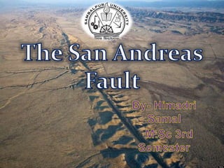
The San Andreas Fault is a continental transform fault that extends roughly 1,200 kilometers through California. It forms the boundary between the Pacific Plate and the North American Plate. The fault results in right-lateral strike-slip motion, with the left side moving northward and the right side moving southward. Major earthquakes are caused by the build up of stress from this motion at various segments of the fault. The fault has had a significant impact throughout California's history, causing damage from earthquakes and other natural disasters.

Recommended
More Related Content
What's hot
What's hot (20)
Similar to The San Andreas Fault: A Geological Force Shaping California
Similar to The San Andreas Fault: A Geological Force Shaping California (20)
More from Himadri Samal
More from Himadri Samal (18)
Recently uploaded
Recently uploaded (20)
The San Andreas Fault: A Geological Force Shaping California
- 2. A Fault is a deep crack in the earth’s crust, most of them are found between two tectonic plate boundaries. The San Andreas Fault is a continental transform fault that extends roughly 1,200 kilometers (750 mi) through California. It forms the tectonic boundary between the Pacific Plate and the North American Plate, and its motion is right-lateral strike-slip San Andreas Fault was named after San Andreas Lake by geologist A.C. Lawson in 1895
- 3. The fault begins in Gulf of California, and travels north through Baja, past the Salton Sea, all the way up to San Francisco and exit’s the bay where it continues to run along the coast until it ends near Eureka, California. The entire San Andreas fault system is more than 800 miles long and extends to depths of at least 10 miles within the Earth.
- 4. Tectonic plates are what make up the earth’s crust where the oceans and continents rest. The name of the tectonic plate that sits on the east side of the San Andreas Fault Line is the North American Plate and on the west side is the Pacific Plate. The southwestward motion of the North American Plate towards the Pacific is creating compressional forces along the eastern side of the fault. The effect is expressed as the Coast Ranges. The northwest movement of the Pacific Plate is also creating significant compressional forces which are especially pronounced where the North American Plate has forced the San Andreas to jog westward. This has led to the formation of the Transverse Ranges in Southern California, and to a lesser but still significant extent,the Santa Cruz Mountains Age: Neogene-Holocene
- 5. The San Andreas Fault is a right lateral strike-slip fault. It means that the left side of the fault is moving northward towards Alaska while the right side is sliding southward toward Mexico.
- 6. The fault divides into five segments, each with different characteristics and a different degree of earthquake risk. The most significant being the southern segment, which passes within about 35 miles (56 km) of Los Angeles. The slip rate along the fault ranges from 20 to 35 mm (0.79 to 1.38 in)/yr. Northern Segment Creeping Segment Parkfield Segment Central Segment Southern Segment
- 7. The Northern segment of the San Andreas fault extends from Shelter Cove to south of the San Francisco Bay area.
- 8. This portion of the San Andreas fault extends from San Juan Bautista, near Monterey, to the short Parkfield segment deep in the Coast Ranges. It exhibits a phenomenon called aseismic creep, where the fault slips continuously without causing earthquakes
- 9. This part of he fault is at the center of the San Andreas fault. Hardly 30 kilometers long, this segment is special because it has its own set of magnitude-6 earthquakes that don't involve the neighboring segments.
- 10. This Segment is defined by the great rupture of 9 January 1857, a magnitude-8 earthquake that broke open the ground for about 350 kilometers from the hamlet of Cholame near Parkfield to Cajon Pass near San Bernardino.
- 11. From Cajon Pass, this segment of the San Andreas fault runs about 300 kilometers to its end on the shores of the Salton Sea
- 12. The San Andreas began to form in the mid Cenozoic about 30 Mya. At this time, a spreading center between the Pacific Plate and the Farallon Plate (which is now mostly subducted, with remnants including the Juan de Fuca Plate, Rivera Plate, Cocos Plate, and the Nazca Plate) was beginning to reach the subduction zone off the western coast of North America. As the relative motion between the Pacific and North American Plates was different from the relative motion between the Farallon and North American Plates, the spreading ridge began to be "subducted", creating a new relative motion and a new style of deformation along the plate boundaries. These geological features are what are chiefly seen along San Andreas Fault. It also includes a possible driver for the deformation of the Basin and Range, separation of the Baja California Peninsula, and rotation of the Transverse Range.
- 14. Disasters Earthquakes Landslide Flashfloods Fires Tsunamis Result from Disasters Property Damage Property Loss Injury Death
- 15. The Great Earthquake of 1906. San Francisco Earthquake of 1989 (also known as the “World Series” Earthquake 1994 Northridge Quake 1992Landers Earthquake
- 16. 1857- Fort Tejon Quake 1899- San Jacinto Fault Quake-6.7 magnitude 1933- Long Beach Earthquake-6.3 magnitude 1986- North Palm Springs Quake-6.1 magnitude 1992- Lander’s Quake-7.3 magnitude 1994- Northridge Quake-6.7 magnitude 1999- Hector Mine Quake-7.1 magnitude
- 17. SOURCES *U.S GEOLOGICAL SURVEY *Geology.com *Wikipedia *Slideshare.net Images:Google.co.in