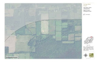
The document is comprised of 51 sheets showing aerial photograph overlays of the Heritage Wind Project area in the Town of Barre, Orleans County, New York. Each sheet displays aerial imagery with overlays showing the 1-mile study area boundary, proposed wind turbine locations, project infrastructure, and other geographic features. Notes provide information on the map source and generation date.
Mapping Landscape Change:
A report assessing landscape change at Dornoch Point, Scotland.
Produced in fulfilment of MSc Geospatial & Mapping Sciences at the University of Glasgow (2015).
Mapping Landscape Change:
A report assessing landscape change at Dornoch Point, Scotland.
Produced in fulfilment of MSc Geospatial & Mapping Sciences at the University of Glasgow (2015).
Hierarchical Digital Twin of a Naval Power SystemKerry Sado
A hierarchical digital twin of a Naval DC power system has been developed and experimentally verified. Similar to other state-of-the-art digital twins, this technology creates a digital replica of the physical system executed in real-time or faster, which can modify hardware controls. However, its advantage stems from distributing computational efforts by utilizing a hierarchical structure composed of lower-level digital twin blocks and a higher-level system digital twin. Each digital twin block is associated with a physical subsystem of the hardware and communicates with a singular system digital twin, which creates a system-level response. By extracting information from each level of the hierarchy, power system controls of the hardware were reconfigured autonomously. This hierarchical digital twin development offers several advantages over other digital twins, particularly in the field of naval power systems. The hierarchical structure allows for greater computational efficiency and scalability while the ability to autonomously reconfigure hardware controls offers increased flexibility and responsiveness. The hierarchical decomposition and models utilized were well aligned with the physical twin, as indicated by the maximum deviations between the developed digital twin hierarchy and the hardware.
Cosmetic shop management system project report.pdfKamal Acharya
Buying new cosmetic products is difficult. It can even be scary for those who have sensitive skin and are prone to skin trouble. The information needed to alleviate this problem is on the back of each product, but it's thought to interpret those ingredient lists unless you have a background in chemistry.
Instead of buying and hoping for the best, we can use data science to help us predict which products may be good fits for us. It includes various function programs to do the above mentioned tasks.
Data file handling has been effectively used in the program.
The automated cosmetic shop management system should deal with the automation of general workflow and administration process of the shop. The main processes of the system focus on customer's request where the system is able to search the most appropriate products and deliver it to the customers. It should help the employees to quickly identify the list of cosmetic product that have reached the minimum quantity and also keep a track of expired date for each cosmetic product. It should help the employees to find the rack number in which the product is placed.It is also Faster and more efficient way.
Welcome to WIPAC Monthly the magazine brought to you by the LinkedIn Group Water Industry Process Automation & Control.
In this month's edition, along with this month's industry news to celebrate the 13 years since the group was created we have articles including
A case study of the used of Advanced Process Control at the Wastewater Treatment works at Lleida in Spain
A look back on an article on smart wastewater networks in order to see how the industry has measured up in the interim around the adoption of Digital Transformation in the Water Industry.
Hybrid optimization of pumped hydro system and solar- Engr. Abdul-Azeez.pdffxintegritypublishin
Advancements in technology unveil a myriad of electrical and electronic breakthroughs geared towards efficiently harnessing limited resources to meet human energy demands. The optimization of hybrid solar PV panels and pumped hydro energy supply systems plays a pivotal role in utilizing natural resources effectively. This initiative not only benefits humanity but also fosters environmental sustainability. The study investigated the design optimization of these hybrid systems, focusing on understanding solar radiation patterns, identifying geographical influences on solar radiation, formulating a mathematical model for system optimization, and determining the optimal configuration of PV panels and pumped hydro storage. Through a comparative analysis approach and eight weeks of data collection, the study addressed key research questions related to solar radiation patterns and optimal system design. The findings highlighted regions with heightened solar radiation levels, showcasing substantial potential for power generation and emphasizing the system's efficiency. Optimizing system design significantly boosted power generation, promoted renewable energy utilization, and enhanced energy storage capacity. The study underscored the benefits of optimizing hybrid solar PV panels and pumped hydro energy supply systems for sustainable energy usage. Optimizing the design of solar PV panels and pumped hydro energy supply systems as examined across diverse climatic conditions in a developing country, not only enhances power generation but also improves the integration of renewable energy sources and boosts energy storage capacities, particularly beneficial for less economically prosperous regions. Additionally, the study provides valuable insights for advancing energy research in economically viable areas. Recommendations included conducting site-specific assessments, utilizing advanced modeling tools, implementing regular maintenance protocols, and enhancing communication among system components.
Saudi Arabia stands as a titan in the global energy landscape, renowned for its abundant oil and gas resources. It's the largest exporter of petroleum and holds some of the world's most significant reserves. Let's delve into the top 10 oil and gas projects shaping Saudi Arabia's energy future in 2024.
About
Indigenized remote control interface card suitable for MAFI system CCR equipment. Compatible for IDM8000 CCR. Backplane mounted serial and TCP/Ethernet communication module for CCR remote access. IDM 8000 CCR remote control on serial and TCP protocol.
• Remote control: Parallel or serial interface.
• Compatible with MAFI CCR system.
• Compatible with IDM8000 CCR.
• Compatible with Backplane mount serial communication.
• Compatible with commercial and Defence aviation CCR system.
• Remote control system for accessing CCR and allied system over serial or TCP.
• Indigenized local Support/presence in India.
• Easy in configuration using DIP switches.
Technical Specifications
Indigenized remote control interface card suitable for MAFI system CCR equipment. Compatible for IDM8000 CCR. Backplane mounted serial and TCP/Ethernet communication module for CCR remote access. IDM 8000 CCR remote control on serial and TCP protocol.
Key Features
Indigenized remote control interface card suitable for MAFI system CCR equipment. Compatible for IDM8000 CCR. Backplane mounted serial and TCP/Ethernet communication module for CCR remote access. IDM 8000 CCR remote control on serial and TCP protocol.
• Remote control: Parallel or serial interface
• Compatible with MAFI CCR system
• Copatiable with IDM8000 CCR
• Compatible with Backplane mount serial communication.
• Compatible with commercial and Defence aviation CCR system.
• Remote control system for accessing CCR and allied system over serial or TCP.
• Indigenized local Support/presence in India.
Application
• Remote control: Parallel or serial interface.
• Compatible with MAFI CCR system.
• Compatible with IDM8000 CCR.
• Compatible with Backplane mount serial communication.
• Compatible with commercial and Defence aviation CCR system.
• Remote control system for accessing CCR and allied system over serial or TCP.
• Indigenized local Support/presence in India.
• Easy in configuration using DIP switches.
Overview of the fundamental roles in Hydropower generation and the components involved in wider Electrical Engineering.
This paper presents the design and construction of hydroelectric dams from the hydrologist’s survey of the valley before construction, all aspects and involved disciplines, fluid dynamics, structural engineering, generation and mains frequency regulation to the very transmission of power through the network in the United Kingdom.
Author: Robbie Edward Sayers
Collaborators and co editors: Charlie Sims and Connor Healey.
(C) 2024 Robbie E. Sayers
Planning Of Procurement o different goods and services
Figure 4-9. Aerial Photograph Overlays
1. Town of
Albion
TuthillRd
County House Rd
CR 76
0 500 1,000250
Feet
www.edrdpc.com
µ
Notes: 1. Basemap: USDA NAIP "2019
New York 1m" orthoimagery map service.
2. This map was generated in ArcMap on
February 3, 2020. 3. This is a color
graphic. Reproduction in grayscale may
misrepresent the data.
Heritage Wind
Project
Town of Barre, Orleans
County, New York
Figure 4-9: Aerial
Photograph Overlays
!
!
!
!
!
!
!
!
! !
!
!
!!
!
!
!
!
!!
!
!!
!
1:6,000
Sheet 1 of 51
1-mile Study Area
2. Town of
Albion
Town of
Murray
HindsburgRdCR91
CR 76
0 500 1,000250
Feet
www.edrdpc.com
µ
Notes: 1. Basemap: USDA NAIP "2019
New York 1m" orthoimagery map service.
2. This map was generated in ArcMap on
February 3, 2020. 3. This is a color
graphic. Reproduction in grayscale may
misrepresent the data.
Heritage Wind
Project
Town of Barre, Orleans
County, New York
Figure 4-9: Aerial
Photograph Overlays
!
!
!
!
!
!
!
!
! !
!
!
!!
!
!
!
!
!!
!
!!
!
1:6,000
Sheet 2 of 51
1-mile Study Area
3. Town of
Albion
Town of Barre
County House Rd
CR 56
UV31A
UV98
0 500 1,000250
Feet
www.edrdpc.com
µ
Notes: 1. Basemap: USDA NAIP "2019
New York 1m" orthoimagery map service.
2. This map was generated in ArcMap on
February 3, 2020. 3. This is a color
graphic. Reproduction in grayscale may
misrepresent the data.
Heritage Wind
Project
Town of Barre, Orleans
County, New York
Figure 4-9: Aerial
Photograph Overlays
!
!
!
!
!
!
!
!
! !
!
!
!!
!
!
!
!
!!
!
!!
!
1:6,000
Sheet 3 of 51
Limit of Clearing
Limit of Disturbance
1-mile Study Area
4. Town of
Albion
Town of Barre
LewisRd
ClarendonRd
County House Rd
UV31A
0 500 1,000250
Feet
www.edrdpc.com
µ
Notes: 1. Basemap: USDA NAIP "2019
New York 1m" orthoimagery map service.
2. This map was generated in ArcMap on
February 3, 2020. 3. This is a color
graphic. Reproduction in grayscale may
misrepresent the data.
Heritage Wind
Project
Town of Barre, Orleans
County, New York
Figure 4-9: Aerial
Photograph Overlays
!
!
!
!
!
!
!
!
! !
!
!
!!
!
!
!
!
!!
!
!!
!
1:6,000
Sheet 4 of 51
1-mile Study Area
5. Town of
Albion
Town of Barre
CR22CR30A
CulverRd
County House Rd
UV31A
0 500 1,000250
Feet
www.edrdpc.com
µ
Notes: 1. Basemap: USDA NAIP "2019
New York 1m" orthoimagery map service.
2. This map was generated in ArcMap on
February 3, 2020. 3. This is a color
graphic. Reproduction in grayscale may
misrepresent the data.
Heritage Wind
Project
Town of Barre, Orleans
County, New York
Figure 4-9: Aerial
Photograph Overlays
!
!
!
!
!
!
!
!
! !
!
!
!!
!
!
!
!
!!
!
!!
!
1:6,000
Sheet 5 of 51
1-mile Study Area
6. Town of
Albion
Town of Barre
Town of
Clarendon
Town of
Murray
RockRd
Powerline RdUV31A
0 500 1,000250
Feet
www.edrdpc.com
µ
Notes: 1. Basemap: USDA NAIP "2019
New York 1m" orthoimagery map service.
2. This map was generated in ArcMap on
February 3, 2020. 3. This is a color
graphic. Reproduction in grayscale may
misrepresent the data.
Heritage Wind
Project
Town of Barre, Orleans
County, New York
Figure 4-9: Aerial
Photograph Overlays
!
!
!
!
!
!
!
!
! !
!
!
!!
!
!
!
!
!!
!
!!
!
1:6,000
Sheet 6 of 51
7. Town of
Clarendon
Town of
Murray
ManningRd
CR83
CR91
Powerline Rd
0 500 1,000250
Feet
www.edrdpc.com
µ
Notes: 1. Basemap: USDA NAIP "2019
New York 1m" orthoimagery map service.
2. This map was generated in ArcMap on
February 3, 2020. 3. This is a color
graphic. Reproduction in grayscale may
misrepresent the data.
Heritage Wind
Project
Town of Barre, Orleans
County, New York
Figure 4-9: Aerial
Photograph Overlays
!
!
!
!
!
!
!
!
! !
!
!
!!
!
!
!
!
!!
!
!!
!
1:6,000
Sheet 7 of 51
1-mile Study Area
8. Town of Barre
JohnnyCakeLn
UV31A
0 500 1,000250
Feet
www.edrdpc.com
µ
Notes: 1. Basemap: USDA NAIP "2019
New York 1m" orthoimagery map service.
2. This map was generated in ArcMap on
February 3, 2020. 3. This is a color
graphic. Reproduction in grayscale may
misrepresent the data.
Heritage Wind
Project
Town of Barre, Orleans
County, New York
Figure 4-9: Aerial
Photograph Overlays
!
!
!
!
!
!
!
!
! !
!
!
!!
!
!
!
!
!!
!
!!
!
1:6,000
Sheet 8 of 51
1-mile Study Area
9. Town of Barre
UV31A
0 500 1,000250
Feet
www.edrdpc.com
µ
Notes: 1. Basemap: USDA NAIP "2019
New York 1m" orthoimagery map service.
2. This map was generated in ArcMap on
February 3, 2020. 3. This is a color
graphic. Reproduction in grayscale may
misrepresent the data.
Heritage Wind
Project
Town of Barre, Orleans
County, New York
Figure 4-9: Aerial
Photograph Overlays
!
!
!
!
!
!
!
!
! !
!
!
!!
!
!
!
!
!!
!
!!
!
1:6,000
Sheet 9 of 51
1-mile Study Area
10. Town of Barre
Lime Kiln Rd
UV98
0 500 1,000250
Feet
www.edrdpc.com
µ
Notes: 1. Basemap: USDA NAIP "2019
New York 1m" orthoimagery map service.
2. This map was generated in ArcMap on
February 3, 2020. 3. This is a color
graphic. Reproduction in grayscale may
misrepresent the data.
Heritage Wind
Project
Town of Barre, Orleans
County, New York
Figure 4-9: Aerial
Photograph Overlays
!
!
!
!
!
!
!
!
! !
!
!
!!
!
!
!
!
!!
!
!!
!
1:6,000
Sheet 10 of 51
11. Town of Barre
Lime Kiln Rd
CulverRd
0 500 1,000250
Feet
www.edrdpc.com
µ
Notes: 1. Basemap: USDA NAIP "2019
New York 1m" orthoimagery map service.
2. This map was generated in ArcMap on
February 3, 2020. 3. This is a color
graphic. Reproduction in grayscale may
misrepresent the data.
Heritage Wind
Project
Town of Barre, Orleans
County, New York
Figure 4-9: Aerial
Photograph Overlays
!
!
!
!
!
!
!
!
! !
!
!
!!
!
!
!
!
!!
!
!!
!
1:6,000
Sheet 11 of 51
Facility Site
12. &=!
&=!
&=!
&=!
Town of Barre
MathesRd
CR 36A
R
ock
R
d
CR69
UV31A
T29
T30
T32
T33
0 500 1,000250
Feet
www.edrdpc.com
µ
Notes: 1. Basemap: USDA NAIP "2019
New York 1m" orthoimagery map service.
2. This map was generated in ArcMap on
February 3, 2020. 3. This is a color
graphic. Reproduction in grayscale may
misrepresent the data.
Heritage Wind
Project
Town of Barre, Orleans
County, New York
Figure 4-9: Aerial
Photograph Overlays
!
!
!
!
!
!
!
!
! !
!
!
!!
!
!
!
!
!!
!
!!
!
1:6,000
Sheet 12 of 51
Limit of Clearing
Limit of Disturbance
&=!
Wind Turbine
Access Road
Collection Line
Facility Site
13. Town of Barre
Town of
Clarendon
ManningRd
CR83
UV31A
0 500 1,000250
Feet
www.edrdpc.com
µ
Notes: 1. Basemap: USDA NAIP "2019
New York 1m" orthoimagery map service.
2. This map was generated in ArcMap on
February 3, 2020. 3. This is a color
graphic. Reproduction in grayscale may
misrepresent the data.
Heritage Wind
Project
Town of Barre, Orleans
County, New York
Figure 4-9: Aerial
Photograph Overlays
!
!
!
!
!
!
!
!
! !
!
!
!!
!
!
!
!
!!
!
!!
!
1:6,000
Sheet 13 of 51
Facility Site
1-mile Study Area
14. Town of Barre
MillerRd
JohnnyCakeLn
Maple St
0 500 1,000250
Feet
www.edrdpc.com
µ
Notes: 1. Basemap: USDA NAIP "2019
New York 1m" orthoimagery map service.
2. This map was generated in ArcMap on
February 3, 2020. 3. This is a color
graphic. Reproduction in grayscale may
misrepresent the data.
Heritage Wind
Project
Town of Barre, Orleans
County, New York
Figure 4-9: Aerial
Photograph Overlays
!
!
!
!
!
!
!
!
! !
!
!
!!
!
!
!
!
!!
!
!!
!
1:6,000
Sheet 14 of 51
Limit of Disturbance
Facility Site
1-mile Study Area
15. Town of Barre
Maple St
0 500 1,000250
Feet
www.edrdpc.com
µ
Notes: 1. Basemap: USDA NAIP "2019
New York 1m" orthoimagery map service.
2. This map was generated in ArcMap on
February 3, 2020. 3. This is a color
graphic. Reproduction in grayscale may
misrepresent the data.
Heritage Wind
Project
Town of Barre, Orleans
County, New York
Figure 4-9: Aerial
Photograph Overlays
!
!
!
!
!
!
!
!
! !
!
!
!!
!
!
!
!
!!
!
!!
!
1:6,000
Sheet 15 of 51
Limit of Disturbance
Access Road
Facility Site
16. Town of Barre
Maple St
CR
69
UV98
0 500 1,000250
Feet
www.edrdpc.com
µ
Notes: 1. Basemap: USDA NAIP "2019
New York 1m" orthoimagery map service.
2. This map was generated in ArcMap on
February 3, 2020. 3. This is a color
graphic. Reproduction in grayscale may
misrepresent the data.
Heritage Wind
Project
Town of Barre, Orleans
County, New York
Figure 4-9: Aerial
Photograph Overlays
!
!
!
!
!
!
!
!
! !
!
!
!!
!
!
!
!
!!
!
!!
!
1:6,000
Sheet 16 of 51
17. #*
Town of Barre
Thorpe Rd
LimeKilnRd
CulverRd
CR 69
0 500 1,000250
Feet
www.edrdpc.com
µ
Notes: 1. Basemap: USDA NAIP "2019
New York 1m" orthoimagery map service.
2. This map was generated in ArcMap on
February 3, 2020. 3. This is a color
graphic. Reproduction in grayscale may
misrepresent the data.
Heritage Wind
Project
Town of Barre, Orleans
County, New York
Figure 4-9: Aerial
Photograph Overlays
!
!
!
!
!
!
!
!
! !
!
!
!!
!
!
!
!
!!
!
!!
!
1:6,000
Sheet 17 of 51
Limit of Disturbance
#* Permanent Met Tower
Access Road
Collection Line
Facility Site
18. #*
&=!
&=!
Town of Barre
AngevineRd
Thorpe
Rd
MathesRd
CR 69
T28
T31
0 500 1,000250
Feet
www.edrdpc.com
µ
Notes: 1. Basemap: USDA NAIP "2019
New York 1m" orthoimagery map service.
2. This map was generated in ArcMap on
February 3, 2020. 3. This is a color
graphic. Reproduction in grayscale may
misrepresent the data.
Heritage Wind
Project
Town of Barre, Orleans
County, New York
Figure 4-9: Aerial
Photograph Overlays
!
!
!
!
!
!
!
!
! !
!
!
!!
!
!
!
!
!!
!
!!
!
1:6,000
Sheet 18 of 51
Limit of Clearing
Limit of Disturbance
&=!
Wind Turbine
Access Road
Collection Line
Facility Site
19. Town of Barre
Town of
Clarendon
ManningRd
CR83
0 500 1,000250
Feet
www.edrdpc.com
µ
Notes: 1. Basemap: USDA NAIP "2019
New York 1m" orthoimagery map service.
2. This map was generated in ArcMap on
February 3, 2020. 3. This is a color
graphic. Reproduction in grayscale may
misrepresent the data.
Heritage Wind
Project
Town of Barre, Orleans
County, New York
Figure 4-9: Aerial
Photograph Overlays
!
!
!
!
!
!
!
!
! !
!
!
!!
!
!
!
!
!!
!
!!
!
1:6,000
Sheet 19 of 51
Facility Site
1-mile Study Area
20. Town of Barre
Miller Rd
CR5
0 500 1,000250
Feet
www.edrdpc.com
µ
Notes: 1. Basemap: USDA NAIP "2019
New York 1m" orthoimagery map service.
2. This map was generated in ArcMap on
February 3, 2020. 3. This is a color
graphic. Reproduction in grayscale may
misrepresent the data.
Heritage Wind
Project
Town of Barre, Orleans
County, New York
Figure 4-9: Aerial
Photograph Overlays
!
!
!
!
!
!
!
!
! !
!
!
!!
!
!
!
!
!!
!
!!
!
1:6,000
Sheet 20 of 51
1-mile Study Area
21. #*
&=!
Town of Barre
CR 99
BraggSchoolhouseRd
T9
0 500 1,000250
Feet
www.edrdpc.com
µ
Notes: 1. Basemap: USDA NAIP "2019
New York 1m" orthoimagery map service.
2. This map was generated in ArcMap on
February 3, 2020. 3. This is a color
graphic. Reproduction in grayscale may
misrepresent the data.
Heritage Wind
Project
Town of Barre, Orleans
County, New York
Figure 4-9: Aerial
Photograph Overlays
!
!
!
!
!
!
!
!
! !
!
!
!!
!
!
!
!
!!
!
!!
!
1:6,000
Sheet 21 of 51
Limit of Clearing
Limit of Disturbance
&=!
Wind Turbine
#* Permanent Met Tower
Access Road
Collection Line
Facility Site
22. &=!
&=!
&=!
&=!
Town of Barre
Barre Rd
CR 99
CR 25B
CR
98
UV98
T10
T11
T12
0 500 1,000250
Feet
www.edrdpc.com
µ
Notes: 1. Basemap: USDA NAIP "2019
New York 1m" orthoimagery map service.
2. This map was generated in ArcMap on
February 3, 2020. 3. This is a color
graphic. Reproduction in grayscale may
misrepresent the data.
Heritage Wind
Project
Town of Barre, Orleans
County, New York
Figure 4-9: Aerial
Photograph Overlays
!
!
!
!
!
!
!
!
! !
!
!
!!
!
!
!
!
!!
!
!!
!
1:6,000
Sheet 22 of 51
Limit of Clearing
Limit of Disturbance
&=!
Wind Turbine
Access Road
Collection Line
Laydown Yard
Facility Site
23. &=!
&=!
&=!
Town of Barre
Cushing
Rd
CR
69
CR
98
CR 36B
CR 25B
T14
T15
T17
0 500 1,000250
Feet
www.edrdpc.com
µ
Notes: 1. Basemap: USDA NAIP "2019
New York 1m" orthoimagery map service.
2. This map was generated in ArcMap on
February 3, 2020. 3. This is a color
graphic. Reproduction in grayscale may
misrepresent the data.
Heritage Wind
Project
Town of Barre, Orleans
County, New York
Figure 4-9: Aerial
Photograph Overlays
!
!
!
!
!
!
!
!
! !
!
!
!!
!
!
!
!
!!
!
!!
!
1:6,000
Sheet 23 of 51
Limit of Clearing
Limit of Disturbance
&=!
Wind Turbine
Access Road
Collection Line
Facility Site
24. &=!
&=!
&=!
&=!
&=!
Town of Barre
CulverRd
T22
T23
T24
T26
T27
0 500 1,000250
Feet
www.edrdpc.com
µ
Notes: 1. Basemap: USDA NAIP "2019
New York 1m" orthoimagery map service.
2. This map was generated in ArcMap on
February 3, 2020. 3. This is a color
graphic. Reproduction in grayscale may
misrepresent the data.
Heritage Wind
Project
Town of Barre, Orleans
County, New York
Figure 4-9: Aerial
Photograph Overlays
!
!
!
!
!
!
!
!
! !
!
!
!!
!
!
!
!
!!
!
!!
!
1:6,000
Sheet 24 of 51
Limit of Clearing
Limit of Disturbance
&=!
Wind Turbine
Access Road
Collection Line
Facility Site
25. Town of Barre
Town of
Clarendon
Mansfield Rd
Brown Schoolhouse Rd
TransitRd
AngevineRd
0 500 1,000250
Feet
www.edrdpc.com
µ
Notes: 1. Basemap: USDA NAIP "2019
New York 1m" orthoimagery map service.
2. This map was generated in ArcMap on
February 3, 2020. 3. This is a color
graphic. Reproduction in grayscale may
misrepresent the data.
Heritage Wind
Project
Town of Barre, Orleans
County, New York
Figure 4-9: Aerial
Photograph Overlays
!
!
!
!
!
!
!
!
! !
!
!
!!
!
!
!
!
!!
!
!!
!
1:6,000
Sheet 25 of 51
Limit of Disturbance
Access Road
Facility Site
1-mile Study Area
26. Town of Barre
Town of
Clarendon
CR83
TransitRd
ManningRd
Mansfield Rd
Brown Schoolhouse Rd
0 500 1,000250
Feet
www.edrdpc.com
µ
Notes: 1. Basemap: USDA NAIP "2019
New York 1m" orthoimagery map service.
2. This map was generated in ArcMap on
February 3, 2020. 3. This is a color
graphic. Reproduction in grayscale may
misrepresent the data.
Heritage Wind
Project
Town of Barre, Orleans
County, New York
Figure 4-9: Aerial
Photograph Overlays
!
!
!
!
!
!
!
!
! !
!
!
!!
!
!
!
!
!!
!
!!
!
1:6,000
Sheet 26 of 51
1-mile Study Area
27. Town of Barre
BurnsRd
Hemlock Ridge Rd
PineHillRd
Gray Rd
0 500 1,000250
Feet
www.edrdpc.com
µ
Notes: 1. Basemap: USDA NAIP "2019
New York 1m" orthoimagery map service.
2. This map was generated in ArcMap on
February 3, 2020. 3. This is a color
graphic. Reproduction in grayscale may
misrepresent the data.
Heritage Wind
Project
Town of Barre, Orleans
County, New York
Figure 4-9: Aerial
Photograph Overlays
!
!
!
!
!
!
!
!
! !
!
!
!!
!
!
!
!
!!
!
!!
!
1:6,000
Sheet 27 of 51
1-mile Study Area
28. Town of Barre
Allis Rd
Gray Rd
CR5
0 500 1,000250
Feet
www.edrdpc.com
µ
Notes: 1. Basemap: USDA NAIP "2019
New York 1m" orthoimagery map service.
2. This map was generated in ArcMap on
February 3, 2020. 3. This is a color
graphic. Reproduction in grayscale may
misrepresent the data.
Heritage Wind
Project
Town of Barre, Orleans
County, New York
Figure 4-9: Aerial
Photograph Overlays
!
!
!
!
!
!
!
!
! !
!
!
!!
!
!
!
!
!!
!
!!
!
1:6,000
Sheet 28 of 51
1-mile Study Area
29. &=!
Town of Barre
BraggSchoolhouseRd
Allis Rd
CR
99
T8
0 500 1,000250
Feet
www.edrdpc.com
µ
Notes: 1. Basemap: USDA NAIP "2019
New York 1m" orthoimagery map service.
2. This map was generated in ArcMap on
February 3, 2020. 3. This is a color
graphic. Reproduction in grayscale may
misrepresent the data.
Heritage Wind
Project
Town of Barre, Orleans
County, New York
Figure 4-9: Aerial
Photograph Overlays
!
!
!
!
!
!
!
!
! !
!
!
!!
!
!
!
!
!!
!
!!
!
1:6,000
Sheet 29 of 51
Limit of Clearing
Limit of Disturbance
&=!
Wind Turbine
Access Road
Collection Line
Facility Site
30. &=!
Town of Barre
Puzzey Rd
Root Rd
UV98
T13
0 500 1,000250
Feet
www.edrdpc.com
µ
Notes: 1. Basemap: USDA NAIP "2019
New York 1m" orthoimagery map service.
2. This map was generated in ArcMap on
February 3, 2020. 3. This is a color
graphic. Reproduction in grayscale may
misrepresent the data.
Heritage Wind
Project
Town of Barre, Orleans
County, New York
Figure 4-9: Aerial
Photograph Overlays
!
!
!
!
!
!
!
!
! !
!
!
!!
!
!
!
!
!!
!
!!
!
1:6,000
Sheet 30 of 51
Limit of Clearing
Limit of Disturbance
&=!
Wind Turbine
Access Road
Collection Line
Facility Site
31. &=!
&=!
&=!
Town of Barre
CushingRd
Puzzey Rd
CR 98
T19
T20
0 500 1,000250
Feet
www.edrdpc.com
µ
Notes: 1. Basemap: USDA NAIP "2019
New York 1m" orthoimagery map service.
2. This map was generated in ArcMap on
February 12, 2020. 3. This is a color
graphic. Reproduction in grayscale may
misrepresent the data.
Heritage Wind
Project
Town of Barre, Orleans
County, New York
Figure 4-9: Aerial
Photograph Overlays
!
!
!
!
!
!
!
!
! !
!
!
!!
!
!
!
!
!!
!
!!
!
1:6,000
Sheet 31 of 51
Limit of Disturbance
&=!
Wind Turbine
Access Road
Collection Line
POI Substation
Collection Substation
O&M Facility
Facility Site
32. &=!
Town of Barre
Delano Steele Rd
CulverRd
AngevineRd
CR
98
T25
0 500 1,000250
Feet
www.edrdpc.com
µ
Notes: 1. Basemap: USDA NAIP "2019
New York 1m" orthoimagery map service.
2. This map was generated in ArcMap on
February 3, 2020. 3. This is a color
graphic. Reproduction in grayscale may
misrepresent the data.
Heritage Wind
Project
Town of Barre, Orleans
County, New York
Figure 4-9: Aerial
Photograph Overlays
!
!
!
!
!
!
!
!
! !
!
!
!!
!
!
!
!
!!
!
!!
!
1:6,000
Sheet 32 of 51
Limit of Clearing
Limit of Disturbance
&=!
Wind Turbine
Access Road
Collection Line
Facility Site
33. Town of Barre
Town of
Clarendon
Angevine
R
d
YahnkeRd
TransitRd
Mcnamar Rd
0 500 1,000250
Feet
www.edrdpc.com
µ
Notes: 1. Basemap: USDA NAIP "2019
New York 1m" orthoimagery map service.
2. This map was generated in ArcMap on
February 3, 2020. 3. This is a color
graphic. Reproduction in grayscale may
misrepresent the data.
Heritage Wind
Project
Town of Barre, Orleans
County, New York
Figure 4-9: Aerial
Photograph Overlays
!
!
!
!
!
!
!
!
! !
!
!
!!
!
!
!
!
!!
!
!!
!
1:6,000
Sheet 33 of 51
Facility Site
1-mile Study Area
34. Town of Barre
Hemlock Ridge Rd
BurnsRd
0 500 1,000250
Feet
www.edrdpc.com
µ
Notes: 1. Basemap: USDA NAIP "2019
New York 1m" orthoimagery map service.
2. This map was generated in ArcMap on
February 3, 2020. 3. This is a color
graphic. Reproduction in grayscale may
misrepresent the data.
Heritage Wind
Project
Town of Barre, Orleans
County, New York
Figure 4-9: Aerial
Photograph Overlays
!
!
!
!
!
!
!
!
! !
!
!
!!
!
!
!
!
!!
!
!!
!
1:6,000
Sheet 34 of 51
Facility Site
1-mile Study Area
35. Town of Barre
Hemlock Ridge Rd
HillRd
CR 99
CR5
CR25
0 500 1,000250
Feet
www.edrdpc.com
µ
Notes: 1. Basemap: USDA NAIP "2019
New York 1m" orthoimagery map service.
2. This map was generated in ArcMap on
February 3, 2020. 3. This is a color
graphic. Reproduction in grayscale may
misrepresent the data.
Heritage Wind
Project
Town of Barre, Orleans
County, New York
Figure 4-9: Aerial
Photograph Overlays
!
!
!
!
!
!
!
!
! !
!
!
!!
!
!
!
!
!!
!
!!
!
1:6,000
Sheet 35 of 51
Limit of Disturbance
Facility Site
36. &=!
Town of Barre
G
illette
Rd
Root Rd
CR99
T7
0 500 1,000250
Feet
www.edrdpc.com
µ
Notes: 1. Basemap: USDA NAIP "2019
New York 1m" orthoimagery map service.
2. This map was generated in ArcMap on
February 3, 2020. 3. This is a color
graphic. Reproduction in grayscale may
misrepresent the data.
Heritage Wind
Project
Town of Barre, Orleans
County, New York
Figure 4-9: Aerial
Photograph Overlays
!
!
!
!
!
!
!
!
! !
!
!
!!
!
!
!
!
!!
!
!!
!
1:6,000
Sheet 36 of 51
Limit of Clearing
Limit of Disturbance
&=!
Wind Turbine
Access Road
Collection Line
Facility Site
37. Town of Barre
Puzzey Rd
Delano Steele Rd
R
oot R
d
G
illette
Rd
UV98
0 500 1,000250
Feet
www.edrdpc.com
µ
Notes: 1. Basemap: USDA NAIP "2019
New York 1m" orthoimagery map service.
2. This map was generated in ArcMap on
February 3, 2020. 3. This is a color
graphic. Reproduction in grayscale may
misrepresent the data.
Heritage Wind
Project
Town of Barre, Orleans
County, New York
Figure 4-9: Aerial
Photograph Overlays
!
!
!
!
!
!
!
!
! !
!
!
!!
!
!
!
!
!!
!
!!
!
1:6,000
Sheet 37 of 51
Limit of Disturbance
Facility Site
38. &=!
&=!
&=!
Town of Barre
Delano Steele Rd
T16
T18
0 500 1,000250
Feet
www.edrdpc.com
µ
Notes: 1. Basemap: USDA NAIP "2019
New York 1m" orthoimagery map service.
2. This map was generated in ArcMap on
February 3, 2020. 3. This is a color
graphic. Reproduction in grayscale may
misrepresent the data.
Heritage Wind
Project
Town of Barre, Orleans
County, New York
Figure 4-9: Aerial
Photograph Overlays
!
!
!
!
!
!
!
!
! !
!
!
!!
!
!
!
!
!!
!
!!
!
1:6,000
Sheet 38 of 51
Limit of Clearing
Limit of Disturbance
&=!
Wind Turbine
Access Road
Collection Line
Facility Site
39. &=!
Town of Barre
Delano Steele Rd
AngevineRd
Sheelar Rd
CR98
T21
0 500 1,000250
Feet
www.edrdpc.com
µ
Notes: 1. Basemap: USDA NAIP "2019
New York 1m" orthoimagery map service.
2. This map was generated in ArcMap on
February 3, 2020. 3. This is a color
graphic. Reproduction in grayscale may
misrepresent the data.
Heritage Wind
Project
Town of Barre, Orleans
County, New York
Figure 4-9: Aerial
Photograph Overlays
!
!
!
!
!
!
!
!
! !
!
!
!!
!
!
!
!
!!
!
!!
!
1:6,000
Sheet 39 of 51
Limit of Clearing
Limit of Disturbance
&=!
Wind Turbine
Access Road
Collection Line
Facility Site
40. Town of Barre
Town of
Clarendon
New Guinea Rd
TransitRd
Sheelar Rd
0 500 1,000250
Feet
www.edrdpc.com
µ
Notes: 1. Basemap: USDA NAIP "2019
New York 1m" orthoimagery map service.
2. This map was generated in ArcMap on
February 3, 2020. 3. This is a color
graphic. Reproduction in grayscale may
misrepresent the data.
Heritage Wind
Project
Town of Barre, Orleans
County, New York
Figure 4-9: Aerial
Photograph Overlays
!
!
!
!
!
!
!
!
! !
!
!
!!
!
!
!
!
!!
!
!!
!
1:6,000
Sheet 40 of 51
1-mile Study Area
41. &=!
&=!
Genesee County
Orleans County
Town of Barre
Town of
Oakfield
Johnson Rd
BurnsRd
CR9
CR
15
T1
T2
0 500 1,000250
Feet
www.edrdpc.com
µ
Notes: 1. Basemap: USDA NAIP "2019
New York 1m" orthoimagery map service.
2. This map was generated in ArcMap on
February 3, 2020. 3. This is a color
graphic. Reproduction in grayscale may
misrepresent the data.
Heritage Wind
Project
Town of Barre, Orleans
County, New York
Figure 4-9: Aerial
Photograph Overlays
!
!
!
!
!
!
!
!
! !
!
!
!!
!
!
!
!
!!
!
!!
!
1:6,000
Sheet 41 of 51
Limit of Clearing
Limit of Disturbance
&=!
Wind Turbine
Access Road
Collection Line
Facility Site
1-mile Study Area
42. &=!
&=!
&=!
Genesee County
Orleans County
Town of Barre
Town of
Oakfield
Gillette Rd
CR25
C
R
15
T3
T4
T5
0 500 1,000250
Feet
www.edrdpc.com
µ
Notes: 1. Basemap: USDA NAIP "2019
New York 1m" orthoimagery map service.
2. This map was generated in ArcMap on
February 3, 2020. 3. This is a color
graphic. Reproduction in grayscale may
misrepresent the data.
Heritage Wind
Project
Town of Barre, Orleans
County, New York
Figure 4-9: Aerial
Photograph Overlays
!
!
!
!
!
!
!
!
! !
!
!
!!
!
!
!
!
!!
!
!!
!
1:6,000
Sheet 42 of 51
Limit of Clearing
Limit of Disturbance
&=!
Wind Turbine
Access Road
Collection Line
Facility Site
43. &=!
Genesee County
Orleans County
Town of Barre
Town of ElbaTown of
Oakfield
Drake Island Road Ext
HillRd
DrakeIslandRd
Gillette Rd
T6
0 500 1,000250
Feet
www.edrdpc.com
µ
Notes: 1. Basemap: USDA NAIP "2019
New York 1m" orthoimagery map service.
2. This map was generated in ArcMap on
February 3, 2020. 3. This is a color
graphic. Reproduction in grayscale may
misrepresent the data.
Heritage Wind
Project
Town of Barre, Orleans
County, New York
Figure 4-9: Aerial
Photograph Overlays
!
!
!
!
!
!
!
!
! !
!
!
!!
!
!
!
!
!!
!
!!
!
1:6,000
Sheet 43 of 51
Limit of Clearing
Limit of Disturbance
&=!
Wind Turbine
Access Road
Collection Line
Facility Site
44. Genesee County
Orleans County
Town of Barre
Town of Elba
Drake Island Road Ext
UV98
0 500 1,000250
Feet
www.edrdpc.com
µ
Notes: 1. Basemap: USDA NAIP "2019
New York 1m" orthoimagery map service.
2. This map was generated in ArcMap on
February 3, 2020. 3. This is a color
graphic. Reproduction in grayscale may
misrepresent the data.
Heritage Wind
Project
Town of Barre, Orleans
County, New York
Figure 4-9: Aerial
Photograph Overlays
!
!
!
!
!
!
!
!
! !
!
!
!!
!
!
!
!
!!
!
!!
!
1:6,000
Sheet 44 of 51
1-mile Study Area
45. Genesee County
Orleans County
Town of Barre
Town of Elba
Spoil Bank Rd
Spoils Bank Rd
CR24
CR98
0 500 1,000250
Feet
www.edrdpc.com
µ
Notes: 1. Basemap: USDA NAIP "2019
New York 1m" orthoimagery map service.
2. This map was generated in ArcMap on
February 3, 2020. 3. This is a color
graphic. Reproduction in grayscale may
misrepresent the data.
Heritage Wind
Project
Town of Barre, Orleans
County, New York
Figure 4-9: Aerial
Photograph Overlays
!
!
!
!
!
!
!
!
! !
!
!
!!
!
!
!
!
!!
!
!!
!
1:6,000
Sheet 45 of 51
Facility Site
1-mile Study Area
46. Genesee County
Orleans County
Town of Barre
Town of Elba
Jakaub Rd
WhiteCityRd
HundredmarkRd
RootIslandRd
Spoil Bank Rd
CR
98
0 500 1,000250
Feet
www.edrdpc.com
µ
Notes: 1. Basemap: USDA NAIP "2019
New York 1m" orthoimagery map service.
2. This map was generated in ArcMap on
February 3, 2020. 3. This is a color
graphic. Reproduction in grayscale may
misrepresent the data.
Heritage Wind
Project
Town of Barre, Orleans
County, New York
Figure 4-9: Aerial
Photograph Overlays
!
!
!
!
!
!
!
!
! !
!
!
!!
!
!
!
!
!!
!
!!
!
1:6,000
Sheet 46 of 51
1-mile Study Area
47. Genesee County
Orleans County
Town of Barre
Town of Byron
Town of
Clarendon
Town of Elba
TownLineRdTransitRd
Spoil Bank Rd
0 500 1,000250
Feet
www.edrdpc.com
µ
Notes: 1. Basemap: USDA NAIP "2019
New York 1m" orthoimagery map service.
2. This map was generated in ArcMap on
February 3, 2020. 3. This is a color
graphic. Reproduction in grayscale may
misrepresent the data.
Heritage Wind
Project
Town of Barre, Orleans
County, New York
Figure 4-9: Aerial
Photograph Overlays
!
!
!
!
!
!
!
!
! !
!
!
!!
!
!
!
!
!!
!
!!
!
1:6,000
Sheet 47 of 51
1-mile Study Area
48. Town of
Oakfield
BurnsRd
CR
22
CR 9
Fisher Rd
0 500 1,000250
Feet
www.edrdpc.com
µ
Notes: 1. Basemap: USDA NAIP "2019
New York 1m" orthoimagery map service.
2. This map was generated in ArcMap on
February 3, 2020. 3. This is a color
graphic. Reproduction in grayscale may
misrepresent the data.
Heritage Wind
Project
Town of Barre, Orleans
County, New York
Figure 4-9: Aerial
Photograph Overlays
!
!
!
!
!
!
!
!
! !
!
!
!!
!
!
!
!
!!
!
!!
!
1:6,000
Sheet 48 of 51
1-mile Study Area
49. Town of
Oakfield
Fisher Rd
0 500 1,000250
Feet
www.edrdpc.com
µ
Notes: 1. Basemap: USDA NAIP "2019
New York 1m" orthoimagery map service.
2. This map was generated in ArcMap on
February 3, 2020. 3. This is a color
graphic. Reproduction in grayscale may
misrepresent the data.
Heritage Wind
Project
Town of Barre, Orleans
County, New York
Figure 4-9: Aerial
Photograph Overlays
!
!
!
!
!
!
!
!
! !
!
!
!!
!
!
!
!
!!
!
!!
!
1:6,000
Sheet 49 of 51
1-mile Study Area
50. Town of Elba
Town of
Oakfield
Muck Rd
0 500 1,000250
Feet
www.edrdpc.com
µ
Notes: 1. Basemap: USDA NAIP "2019
New York 1m" orthoimagery map service.
2. This map was generated in ArcMap on
February 3, 2020. 3. This is a color
graphic. Reproduction in grayscale may
misrepresent the data.
Heritage Wind
Project
Town of Barre, Orleans
County, New York
Figure 4-9: Aerial
Photograph Overlays
!
!
!
!
!
!
!
!
! !
!
!
!!
!
!
!
!
!!
!
!!
!
1:6,000
Sheet 50 of 51
1-mile Study Area
51. Genesee County
Orleans County
Town of Barre
Town of Elba
DrakeIslandRd
Muck Rd
0 500 1,000250
Feet
www.edrdpc.com
µ
Notes: 1. Basemap: USDA NAIP "2019
New York 1m" orthoimagery map service.
2. This map was generated in ArcMap on
February 3, 2020. 3. This is a color
graphic. Reproduction in grayscale may
misrepresent the data.
Heritage Wind
Project
Town of Barre, Orleans
County, New York
Figure 4-9: Aerial
Photograph Overlays
!
!
!
!
!
!
!
!
! !
!
!
!!
!
!
!
!
!!
!
!!
!
1:6,000
Sheet 51 of 51
1-mile Study Area