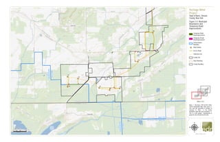
SlideShare a Scribd company logo
&=!
&=!
&=!
&=!
&=!
&=!
&=!
&=!
Oak Orchard Creek
Schmidt Marsh
Upper
Stafford
Marsh
W Muck Rd
Albion Rd
DrakeIslandRd
Gillette Rd
Johnson Rd
Root Rd
HillRd
E Shelby Rd
Hem
lock
Ridge
Rd
BurnsRd
Allis Rd
W
Barre
Rd
Drake Island Road Ext
PineHillRd
EagleHarborRd
Fisher Rd
Gray Rd
Genesee County
Orleans County
Town of Barre
Town of Elba
Town of
Oakfield
ElbaCSD
Oakfield-Alabama
CSD
Elba CSD
Albion CSD
Oakfield-Alabama
CSD
AlbionCSD
T1
T2
T3
T4
T5
T6
T7
T8
0 1,000 2,000500
Feet
www.edrdpc.com
µ
Notes: 1. Basemap: ESRI ArcGIS Online
"USGS Topographic Map" map service 2.
This map was generated in ArcMap on
February 12, 2020. 3. Fire District
Boundaries align with Town Boundaries. 4.
This is a color graphic. Reproduction in
grayscale may misrepresent the data.
Heritage Wind
Project
Town of Barre, Orleans
County, New York
Figure 3-3: Municipal
Boundaries and
Temporary Road
Improvements
Temporary Public
Road Improvement
Temporary Private
Road Improvement
School District
Boundary
&=! Wind Turbine
Access Road
Collection Line
Facility Site
Town Boundary
County Boundary
1:24,000
Sheet 1 of 3
#*
#*
&=!
&=!
&=!
&=!
&=!
&=!
&=!
&=!
&=!
&=!
&=!
&=!
&=!
&=!
&=!
&=!
&=!
&=!
&=!
&=!
&=!
&=!
Manning Muckland Creek
W
BranchSandyCreek
RootIsland
Rd
Mcnamar Rd
Maple St
SLimeKilnRd Sheelar Rd
Delano Steele Rd
CulverRd
CR 99
G
illette
Rd
Angevine
Rd
R
ootR
d
Allis Rd
Thorpe Rd
W
Barre Rd
MathesRd
CushingRd
BraggSchoolhouseRd
Puzzey Rd
E Barre Rd
Oak Orchard Rd
QuakerHillRd
ST98 Town of Barre
HolleyCSD
AlbionCSD
MET-1
MET-2
T7
T8
T9
T10
T11
T12
T13
T14
T15
T16
T17
T18
T19
T20
T21
T22
T23
T24
T25
T26
T27
T28
0 1,000 2,000500
Feet
www.edrdpc.com
µ
Notes: 1. Basemap: ESRI ArcGIS Online
"USGS Topographic Map" map service 2.
This map was generated in ArcMap on
February 12, 2020. 3. Fire District
Boundaries align with Town Boundaries. 4.
This is a color graphic. Reproduction in
grayscale may misrepresent the data.
Heritage Wind
Project
Town of Barre, Orleans
County, New York
Figure 3-3: Municipal
Boundaries and
Temporary Road
Improvements
Temporary Public
Road Improvement
Temporary Private
Road Improvement
School District
Boundary
&=! Wind Turbine
#* Permanent Met Tower
Access Road
Collection Line
POI Substation
Collection Substation
O&M Facility
Laydown Yard
Facility Site
Town Boundary
County Boundary
1:24,000
Sheet 2 of 3
#*
&=!
&=! &=!
&=!
&=!
&=!
&=!
&=!
&=!
&=!
&=!
&=!
&=!
&=!
&=!
&=!
&=!
&=!
ManningMucklandCreek
W
BranchSandyCreek
Brown Schoolhouse Rd
Thorpe Rd
LewisRd
YahnkeRd
HindsburgRd
TransitRd
CR 36A
Powerline Rd
CR 99
AngevineRd
Lime Kiln Rd
Maple St
CR83
CulverRd
SLimeKilnRd
Mansfield Rd
Mcnamar RdMathesRd
CushingRd
OakOrchardRd
E Barre Rd
E Lee Rd
W Lee Rd QuakerHillRd
ST98
ST31A
Town of
Albion
Town of Barre
Town of
Clarendon
Town of
Murray
HolleyCSD
AlbionCSD
MET-2
T14
T15
T17
T20
T22
T23
T24
T25
T26
T27
T28
T29
T30
T31
T32
T33
0 1,000 2,000500
Feet
www.edrdpc.com
µ
Notes: 1. Basemap: ESRI ArcGIS Online
"USGS Topographic Map" map service 2.
This map was generated in ArcMap on
February 12, 2020. 3. Fire District
Boundaries align with Town Boundaries. 4.
This is a color graphic. Reproduction in
grayscale may misrepresent the data.
Heritage Wind
Project
Town of Barre, Orleans
County, New York
Figure 3-3: Municipal
Boundaries and
Temporary Road
Improvements
Temporary Public
Road Improvement
Temporary Private
Road Improvement
School District
Boundary
&=! Wind Turbine
#* Permanent Met Tower
Access Road
Collection Line
Laydown Yard
Facility Site
Town Boundary
County Boundary
1:24,000
Sheet 3 of 3

More Related Content

Similar to Figure 3-3. Municipal Boundaries Temp Road Improvements

Figure 4-9. Aerial Photograph Overlays
Figure 4-9. Aerial Photograph OverlaysFigure 4-9. Aerial Photograph Overlays
Figure 4-9. Aerial Photograph Overlays
Heritage Wind
 
Figure 2-2. Facility Layout
Figure 2-2. Facility LayoutFigure 2-2. Facility Layout
Figure 2-2. Facility Layout
Heritage Wind
 
Figure 3-1. Proposed Major Electric Generating Facility Location
Figure 3-1. Proposed Major Electric Generating Facility LocationFigure 3-1. Proposed Major Electric Generating Facility Location
Figure 3-1. Proposed Major Electric Generating Facility Location
Heritage Wind
 
Figure 22-1. Impact to Plant Communities (Part 1)
Figure 22-1. Impact to Plant Communities (Part 1)Figure 22-1. Impact to Plant Communities (Part 1)
Figure 22-1. Impact to Plant Communities (Part 1)
Heritage Wind
 
Figure 13 1. Real Property Map
Figure 13 1. Real Property MapFigure 13 1. Real Property Map
Figure 13 1. Real Property Map
Heritage Wind
 
Figure 4-7. Specially Designated Areas
Figure 4-7. Specially Designated AreasFigure 4-7. Specially Designated Areas
Figure 4-7. Specially Designated Areas
Heritage Wind
 
Figure 4-6. Proposed Land Use
Figure 4-6. Proposed Land UseFigure 4-6. Proposed Land Use
Figure 4-6. Proposed Land Use
Heritage Wind
 

Similar to Figure 3-3. Municipal Boundaries Temp Road Improvements (7)

Figure 4-9. Aerial Photograph Overlays
Figure 4-9. Aerial Photograph OverlaysFigure 4-9. Aerial Photograph Overlays
Figure 4-9. Aerial Photograph Overlays
 
Figure 2-2. Facility Layout
Figure 2-2. Facility LayoutFigure 2-2. Facility Layout
Figure 2-2. Facility Layout
 
Figure 3-1. Proposed Major Electric Generating Facility Location
Figure 3-1. Proposed Major Electric Generating Facility LocationFigure 3-1. Proposed Major Electric Generating Facility Location
Figure 3-1. Proposed Major Electric Generating Facility Location
 
Figure 22-1. Impact to Plant Communities (Part 1)
Figure 22-1. Impact to Plant Communities (Part 1)Figure 22-1. Impact to Plant Communities (Part 1)
Figure 22-1. Impact to Plant Communities (Part 1)
 
Figure 13 1. Real Property Map
Figure 13 1. Real Property MapFigure 13 1. Real Property Map
Figure 13 1. Real Property Map
 
Figure 4-7. Specially Designated Areas
Figure 4-7. Specially Designated AreasFigure 4-7. Specially Designated Areas
Figure 4-7. Specially Designated Areas
 
Figure 4-6. Proposed Land Use
Figure 4-6. Proposed Land UseFigure 4-6. Proposed Land Use
Figure 4-6. Proposed Land Use
 

More from Heritage Wind

Caddo Wind Virtual Public Meeting Presentation
Caddo Wind Virtual Public Meeting PresentationCaddo Wind Virtual Public Meeting Presentation
Caddo Wind Virtual Public Meeting Presentation
Heritage Wind
 
Figure 3.1-1. Visual Study Area
Figure 3.1-1. Visual Study AreaFigure 3.1-1. Visual Study Area
Figure 3.1-1. Visual Study Area
Heritage Wind
 
Figure 6 1. Setbacks
Figure 6 1. SetbacksFigure 6 1. Setbacks
Figure 6 1. Setbacks
Heritage Wind
 
Figure 3.1-1. Visual Study Area
Figure 3.1-1. Visual Study AreaFigure 3.1-1. Visual Study Area
Figure 3.1-1. Visual Study Area
Heritage Wind
 
Figure 4-2. Land Use Programs
Figure 4-2. Land Use ProgramsFigure 4-2. Land Use Programs
Figure 4-2. Land Use Programs
Heritage Wind
 
Figure 4-1. Existing Land Use
Figure 4-1. Existing Land UseFigure 4-1. Existing Land Use
Figure 4-1. Existing Land Use
Heritage Wind
 
Figure 3-2. Interconnection Location
Figure 3-2. Interconnection LocationFigure 3-2. Interconnection Location
Figure 3-2. Interconnection Location
Heritage Wind
 
Figure 23-2. Surface Waters
Figure 23-2. Surface WatersFigure 23-2. Surface Waters
Figure 23-2. Surface Waters
Heritage Wind
 
Figure 22-3. Delineated Wetlands and Surface Waters
Figure 22-3. Delineated Wetlands and Surface WatersFigure 22-3. Delineated Wetlands and Surface Waters
Figure 22-3. Delineated Wetlands and Surface Waters
Heritage Wind
 
Figure 22-2. Significant Natural Communities
Figure 22-2. Significant Natural CommunitiesFigure 22-2. Significant Natural Communities
Figure 22-2. Significant Natural Communities
Heritage Wind
 
Figure 22-1. Impact to Plant Communities (Part 2)
Figure 22-1. Impact to Plant Communities (Part 2)Figure 22-1. Impact to Plant Communities (Part 2)
Figure 22-1. Impact to Plant Communities (Part 2)
Heritage Wind
 
Figure 21-2. Soil Types
Figure 21-2. Soil TypesFigure 21-2. Soil Types
Figure 21-2. Soil Types
Heritage Wind
 
Figure 19-1. Sensitive Receptor Locations
Figure 19-1. Sensitive Receptor LocationsFigure 19-1. Sensitive Receptor Locations
Figure 19-1. Sensitive Receptor Locations
Heritage Wind
 
Figure 15-1. Public Health and Safety Maps
Figure 15-1. Public Health and Safety MapsFigure 15-1. Public Health and Safety Maps
Figure 15-1. Public Health and Safety Maps
Heritage Wind
 
Figure 9 1. Facility Site Comparison Map
Figure 9 1. Facility Site Comparison MapFigure 9 1. Facility Site Comparison Map
Figure 9 1. Facility Site Comparison Map
Heritage Wind
 
Figure 4-8. Recreational Area and Other Sensitive Land Uses
Figure 4-8. Recreational Area and Other Sensitive Land UsesFigure 4-8. Recreational Area and Other Sensitive Land Uses
Figure 4-8. Recreational Area and Other Sensitive Land Uses
Heritage Wind
 
Figure 4-5. Zoning District
Figure 4-5. Zoning DistrictFigure 4-5. Zoning District
Figure 4-5. Zoning District
Heritage Wind
 
Figure 4-4. Tax Parcel
Figure 4-4. Tax ParcelFigure 4-4. Tax Parcel
Figure 4-4. Tax Parcel
Heritage Wind
 
Alder Creek Solar February 2020 Public Information Meetings
Alder Creek Solar February 2020 Public Information MeetingsAlder Creek Solar February 2020 Public Information Meetings
Alder Creek Solar February 2020 Public Information Meetings
Heritage Wind
 
DOW Public Meeting Slides 2.5.20
DOW Public Meeting Slides 2.5.20DOW Public Meeting Slides 2.5.20
DOW Public Meeting Slides 2.5.20
Heritage Wind
 

More from Heritage Wind (20)

Caddo Wind Virtual Public Meeting Presentation
Caddo Wind Virtual Public Meeting PresentationCaddo Wind Virtual Public Meeting Presentation
Caddo Wind Virtual Public Meeting Presentation
 
Figure 3.1-1. Visual Study Area
Figure 3.1-1. Visual Study AreaFigure 3.1-1. Visual Study Area
Figure 3.1-1. Visual Study Area
 
Figure 6 1. Setbacks
Figure 6 1. SetbacksFigure 6 1. Setbacks
Figure 6 1. Setbacks
 
Figure 3.1-1. Visual Study Area
Figure 3.1-1. Visual Study AreaFigure 3.1-1. Visual Study Area
Figure 3.1-1. Visual Study Area
 
Figure 4-2. Land Use Programs
Figure 4-2. Land Use ProgramsFigure 4-2. Land Use Programs
Figure 4-2. Land Use Programs
 
Figure 4-1. Existing Land Use
Figure 4-1. Existing Land UseFigure 4-1. Existing Land Use
Figure 4-1. Existing Land Use
 
Figure 3-2. Interconnection Location
Figure 3-2. Interconnection LocationFigure 3-2. Interconnection Location
Figure 3-2. Interconnection Location
 
Figure 23-2. Surface Waters
Figure 23-2. Surface WatersFigure 23-2. Surface Waters
Figure 23-2. Surface Waters
 
Figure 22-3. Delineated Wetlands and Surface Waters
Figure 22-3. Delineated Wetlands and Surface WatersFigure 22-3. Delineated Wetlands and Surface Waters
Figure 22-3. Delineated Wetlands and Surface Waters
 
Figure 22-2. Significant Natural Communities
Figure 22-2. Significant Natural CommunitiesFigure 22-2. Significant Natural Communities
Figure 22-2. Significant Natural Communities
 
Figure 22-1. Impact to Plant Communities (Part 2)
Figure 22-1. Impact to Plant Communities (Part 2)Figure 22-1. Impact to Plant Communities (Part 2)
Figure 22-1. Impact to Plant Communities (Part 2)
 
Figure 21-2. Soil Types
Figure 21-2. Soil TypesFigure 21-2. Soil Types
Figure 21-2. Soil Types
 
Figure 19-1. Sensitive Receptor Locations
Figure 19-1. Sensitive Receptor LocationsFigure 19-1. Sensitive Receptor Locations
Figure 19-1. Sensitive Receptor Locations
 
Figure 15-1. Public Health and Safety Maps
Figure 15-1. Public Health and Safety MapsFigure 15-1. Public Health and Safety Maps
Figure 15-1. Public Health and Safety Maps
 
Figure 9 1. Facility Site Comparison Map
Figure 9 1. Facility Site Comparison MapFigure 9 1. Facility Site Comparison Map
Figure 9 1. Facility Site Comparison Map
 
Figure 4-8. Recreational Area and Other Sensitive Land Uses
Figure 4-8. Recreational Area and Other Sensitive Land UsesFigure 4-8. Recreational Area and Other Sensitive Land Uses
Figure 4-8. Recreational Area and Other Sensitive Land Uses
 
Figure 4-5. Zoning District
Figure 4-5. Zoning DistrictFigure 4-5. Zoning District
Figure 4-5. Zoning District
 
Figure 4-4. Tax Parcel
Figure 4-4. Tax ParcelFigure 4-4. Tax Parcel
Figure 4-4. Tax Parcel
 
Alder Creek Solar February 2020 Public Information Meetings
Alder Creek Solar February 2020 Public Information MeetingsAlder Creek Solar February 2020 Public Information Meetings
Alder Creek Solar February 2020 Public Information Meetings
 
DOW Public Meeting Slides 2.5.20
DOW Public Meeting Slides 2.5.20DOW Public Meeting Slides 2.5.20
DOW Public Meeting Slides 2.5.20
 

Recently uploaded

Pile Foundation by Venkatesh Taduvai (Sub Geotechnical Engineering II)-conver...
Pile Foundation by Venkatesh Taduvai (Sub Geotechnical Engineering II)-conver...Pile Foundation by Venkatesh Taduvai (Sub Geotechnical Engineering II)-conver...
Pile Foundation by Venkatesh Taduvai (Sub Geotechnical Engineering II)-conver...
AJAYKUMARPUND1
 
The role of big data in decision making.
The role of big data in decision making.The role of big data in decision making.
The role of big data in decision making.
ankuprajapati0525
 
Industrial Training at Shahjalal Fertilizer Company Limited (SFCL)
Industrial Training at Shahjalal Fertilizer Company Limited (SFCL)Industrial Training at Shahjalal Fertilizer Company Limited (SFCL)
Industrial Training at Shahjalal Fertilizer Company Limited (SFCL)
MdTanvirMahtab2
 
H.Seo, ICLR 2024, MLILAB, KAIST AI.pdf
H.Seo,  ICLR 2024, MLILAB,  KAIST AI.pdfH.Seo,  ICLR 2024, MLILAB,  KAIST AI.pdf
H.Seo, ICLR 2024, MLILAB, KAIST AI.pdf
MLILAB
 
DESIGN A COTTON SEED SEPARATION MACHINE.docx
DESIGN A COTTON SEED SEPARATION MACHINE.docxDESIGN A COTTON SEED SEPARATION MACHINE.docx
DESIGN A COTTON SEED SEPARATION MACHINE.docx
FluxPrime1
 
一比一原版(UofT毕业证)多伦多大学毕业证成绩单如何办理
一比一原版(UofT毕业证)多伦多大学毕业证成绩单如何办理一比一原版(UofT毕业证)多伦多大学毕业证成绩单如何办理
一比一原版(UofT毕业证)多伦多大学毕业证成绩单如何办理
ydteq
 
WATER CRISIS and its solutions-pptx 1234
WATER CRISIS and its solutions-pptx 1234WATER CRISIS and its solutions-pptx 1234
WATER CRISIS and its solutions-pptx 1234
AafreenAbuthahir2
 
Fundamentals of Electric Drives and its applications.pptx
Fundamentals of Electric Drives and its applications.pptxFundamentals of Electric Drives and its applications.pptx
Fundamentals of Electric Drives and its applications.pptx
manasideore6
 
Planning Of Procurement o different goods and services
Planning Of Procurement o different goods and servicesPlanning Of Procurement o different goods and services
Planning Of Procurement o different goods and services
JoytuBarua2
 
HYDROPOWER - Hydroelectric power generation
HYDROPOWER - Hydroelectric power generationHYDROPOWER - Hydroelectric power generation
HYDROPOWER - Hydroelectric power generation
Robbie Edward Sayers
 
ethical hacking in wireless-hacking1.ppt
ethical hacking in wireless-hacking1.pptethical hacking in wireless-hacking1.ppt
ethical hacking in wireless-hacking1.ppt
Jayaprasanna4
 
一比一原版(IIT毕业证)伊利诺伊理工大学毕业证成绩单专业办理
一比一原版(IIT毕业证)伊利诺伊理工大学毕业证成绩单专业办理一比一原版(IIT毕业证)伊利诺伊理工大学毕业证成绩单专业办理
一比一原版(IIT毕业证)伊利诺伊理工大学毕业证成绩单专业办理
zwunae
 
一比一原版(SFU毕业证)西蒙菲莎大学毕业证成绩单如何办理
一比一原版(SFU毕业证)西蒙菲莎大学毕业证成绩单如何办理一比一原版(SFU毕业证)西蒙菲莎大学毕业证成绩单如何办理
一比一原版(SFU毕业证)西蒙菲莎大学毕业证成绩单如何办理
bakpo1
 
ASME IX(9) 2007 Full Version .pdf
ASME IX(9)  2007 Full Version       .pdfASME IX(9)  2007 Full Version       .pdf
ASME IX(9) 2007 Full Version .pdf
AhmedHussein950959
 
road safety engineering r s e unit 3.pdf
road safety engineering  r s e unit 3.pdfroad safety engineering  r s e unit 3.pdf
road safety engineering r s e unit 3.pdf
VENKATESHvenky89705
 
Student information management system project report ii.pdf
Student information management system project report ii.pdfStudent information management system project report ii.pdf
Student information management system project report ii.pdf
Kamal Acharya
 
Final project report on grocery store management system..pdf
Final project report on grocery store management system..pdfFinal project report on grocery store management system..pdf
Final project report on grocery store management system..pdf
Kamal Acharya
 
Hybrid optimization of pumped hydro system and solar- Engr. Abdul-Azeez.pdf
Hybrid optimization of pumped hydro system and solar- Engr. Abdul-Azeez.pdfHybrid optimization of pumped hydro system and solar- Engr. Abdul-Azeez.pdf
Hybrid optimization of pumped hydro system and solar- Engr. Abdul-Azeez.pdf
fxintegritypublishin
 
CME397 Surface Engineering- Professional Elective
CME397 Surface Engineering- Professional ElectiveCME397 Surface Engineering- Professional Elective
CME397 Surface Engineering- Professional Elective
karthi keyan
 
Nuclear Power Economics and Structuring 2024
Nuclear Power Economics and Structuring 2024Nuclear Power Economics and Structuring 2024
Nuclear Power Economics and Structuring 2024
Massimo Talia
 

Recently uploaded (20)

Pile Foundation by Venkatesh Taduvai (Sub Geotechnical Engineering II)-conver...
Pile Foundation by Venkatesh Taduvai (Sub Geotechnical Engineering II)-conver...Pile Foundation by Venkatesh Taduvai (Sub Geotechnical Engineering II)-conver...
Pile Foundation by Venkatesh Taduvai (Sub Geotechnical Engineering II)-conver...
 
The role of big data in decision making.
The role of big data in decision making.The role of big data in decision making.
The role of big data in decision making.
 
Industrial Training at Shahjalal Fertilizer Company Limited (SFCL)
Industrial Training at Shahjalal Fertilizer Company Limited (SFCL)Industrial Training at Shahjalal Fertilizer Company Limited (SFCL)
Industrial Training at Shahjalal Fertilizer Company Limited (SFCL)
 
H.Seo, ICLR 2024, MLILAB, KAIST AI.pdf
H.Seo,  ICLR 2024, MLILAB,  KAIST AI.pdfH.Seo,  ICLR 2024, MLILAB,  KAIST AI.pdf
H.Seo, ICLR 2024, MLILAB, KAIST AI.pdf
 
DESIGN A COTTON SEED SEPARATION MACHINE.docx
DESIGN A COTTON SEED SEPARATION MACHINE.docxDESIGN A COTTON SEED SEPARATION MACHINE.docx
DESIGN A COTTON SEED SEPARATION MACHINE.docx
 
一比一原版(UofT毕业证)多伦多大学毕业证成绩单如何办理
一比一原版(UofT毕业证)多伦多大学毕业证成绩单如何办理一比一原版(UofT毕业证)多伦多大学毕业证成绩单如何办理
一比一原版(UofT毕业证)多伦多大学毕业证成绩单如何办理
 
WATER CRISIS and its solutions-pptx 1234
WATER CRISIS and its solutions-pptx 1234WATER CRISIS and its solutions-pptx 1234
WATER CRISIS and its solutions-pptx 1234
 
Fundamentals of Electric Drives and its applications.pptx
Fundamentals of Electric Drives and its applications.pptxFundamentals of Electric Drives and its applications.pptx
Fundamentals of Electric Drives and its applications.pptx
 
Planning Of Procurement o different goods and services
Planning Of Procurement o different goods and servicesPlanning Of Procurement o different goods and services
Planning Of Procurement o different goods and services
 
HYDROPOWER - Hydroelectric power generation
HYDROPOWER - Hydroelectric power generationHYDROPOWER - Hydroelectric power generation
HYDROPOWER - Hydroelectric power generation
 
ethical hacking in wireless-hacking1.ppt
ethical hacking in wireless-hacking1.pptethical hacking in wireless-hacking1.ppt
ethical hacking in wireless-hacking1.ppt
 
一比一原版(IIT毕业证)伊利诺伊理工大学毕业证成绩单专业办理
一比一原版(IIT毕业证)伊利诺伊理工大学毕业证成绩单专业办理一比一原版(IIT毕业证)伊利诺伊理工大学毕业证成绩单专业办理
一比一原版(IIT毕业证)伊利诺伊理工大学毕业证成绩单专业办理
 
一比一原版(SFU毕业证)西蒙菲莎大学毕业证成绩单如何办理
一比一原版(SFU毕业证)西蒙菲莎大学毕业证成绩单如何办理一比一原版(SFU毕业证)西蒙菲莎大学毕业证成绩单如何办理
一比一原版(SFU毕业证)西蒙菲莎大学毕业证成绩单如何办理
 
ASME IX(9) 2007 Full Version .pdf
ASME IX(9)  2007 Full Version       .pdfASME IX(9)  2007 Full Version       .pdf
ASME IX(9) 2007 Full Version .pdf
 
road safety engineering r s e unit 3.pdf
road safety engineering  r s e unit 3.pdfroad safety engineering  r s e unit 3.pdf
road safety engineering r s e unit 3.pdf
 
Student information management system project report ii.pdf
Student information management system project report ii.pdfStudent information management system project report ii.pdf
Student information management system project report ii.pdf
 
Final project report on grocery store management system..pdf
Final project report on grocery store management system..pdfFinal project report on grocery store management system..pdf
Final project report on grocery store management system..pdf
 
Hybrid optimization of pumped hydro system and solar- Engr. Abdul-Azeez.pdf
Hybrid optimization of pumped hydro system and solar- Engr. Abdul-Azeez.pdfHybrid optimization of pumped hydro system and solar- Engr. Abdul-Azeez.pdf
Hybrid optimization of pumped hydro system and solar- Engr. Abdul-Azeez.pdf
 
CME397 Surface Engineering- Professional Elective
CME397 Surface Engineering- Professional ElectiveCME397 Surface Engineering- Professional Elective
CME397 Surface Engineering- Professional Elective
 
Nuclear Power Economics and Structuring 2024
Nuclear Power Economics and Structuring 2024Nuclear Power Economics and Structuring 2024
Nuclear Power Economics and Structuring 2024
 

Figure 3-3. Municipal Boundaries Temp Road Improvements

  • 1. &=! &=! &=! &=! &=! &=! &=! &=! Oak Orchard Creek Schmidt Marsh Upper Stafford Marsh W Muck Rd Albion Rd DrakeIslandRd Gillette Rd Johnson Rd Root Rd HillRd E Shelby Rd Hem lock Ridge Rd BurnsRd Allis Rd W Barre Rd Drake Island Road Ext PineHillRd EagleHarborRd Fisher Rd Gray Rd Genesee County Orleans County Town of Barre Town of Elba Town of Oakfield ElbaCSD Oakfield-Alabama CSD Elba CSD Albion CSD Oakfield-Alabama CSD AlbionCSD T1 T2 T3 T4 T5 T6 T7 T8 0 1,000 2,000500 Feet www.edrdpc.com µ Notes: 1. Basemap: ESRI ArcGIS Online "USGS Topographic Map" map service 2. This map was generated in ArcMap on February 12, 2020. 3. Fire District Boundaries align with Town Boundaries. 4. This is a color graphic. Reproduction in grayscale may misrepresent the data. Heritage Wind Project Town of Barre, Orleans County, New York Figure 3-3: Municipal Boundaries and Temporary Road Improvements Temporary Public Road Improvement Temporary Private Road Improvement School District Boundary &=! Wind Turbine Access Road Collection Line Facility Site Town Boundary County Boundary 1:24,000 Sheet 1 of 3
  • 2. #* #* &=! &=! &=! &=! &=! &=! &=! &=! &=! &=! &=! &=! &=! &=! &=! &=! &=! &=! &=! &=! &=! &=! Manning Muckland Creek W BranchSandyCreek RootIsland Rd Mcnamar Rd Maple St SLimeKilnRd Sheelar Rd Delano Steele Rd CulverRd CR 99 G illette Rd Angevine Rd R ootR d Allis Rd Thorpe Rd W Barre Rd MathesRd CushingRd BraggSchoolhouseRd Puzzey Rd E Barre Rd Oak Orchard Rd QuakerHillRd ST98 Town of Barre HolleyCSD AlbionCSD MET-1 MET-2 T7 T8 T9 T10 T11 T12 T13 T14 T15 T16 T17 T18 T19 T20 T21 T22 T23 T24 T25 T26 T27 T28 0 1,000 2,000500 Feet www.edrdpc.com µ Notes: 1. Basemap: ESRI ArcGIS Online "USGS Topographic Map" map service 2. This map was generated in ArcMap on February 12, 2020. 3. Fire District Boundaries align with Town Boundaries. 4. This is a color graphic. Reproduction in grayscale may misrepresent the data. Heritage Wind Project Town of Barre, Orleans County, New York Figure 3-3: Municipal Boundaries and Temporary Road Improvements Temporary Public Road Improvement Temporary Private Road Improvement School District Boundary &=! Wind Turbine #* Permanent Met Tower Access Road Collection Line POI Substation Collection Substation O&M Facility Laydown Yard Facility Site Town Boundary County Boundary 1:24,000 Sheet 2 of 3
  • 3. #* &=! &=! &=! &=! &=! &=! &=! &=! &=! &=! &=! &=! &=! &=! &=! &=! &=! &=! ManningMucklandCreek W BranchSandyCreek Brown Schoolhouse Rd Thorpe Rd LewisRd YahnkeRd HindsburgRd TransitRd CR 36A Powerline Rd CR 99 AngevineRd Lime Kiln Rd Maple St CR83 CulverRd SLimeKilnRd Mansfield Rd Mcnamar RdMathesRd CushingRd OakOrchardRd E Barre Rd E Lee Rd W Lee Rd QuakerHillRd ST98 ST31A Town of Albion Town of Barre Town of Clarendon Town of Murray HolleyCSD AlbionCSD MET-2 T14 T15 T17 T20 T22 T23 T24 T25 T26 T27 T28 T29 T30 T31 T32 T33 0 1,000 2,000500 Feet www.edrdpc.com µ Notes: 1. Basemap: ESRI ArcGIS Online "USGS Topographic Map" map service 2. This map was generated in ArcMap on February 12, 2020. 3. Fire District Boundaries align with Town Boundaries. 4. This is a color graphic. Reproduction in grayscale may misrepresent the data. Heritage Wind Project Town of Barre, Orleans County, New York Figure 3-3: Municipal Boundaries and Temporary Road Improvements Temporary Public Road Improvement Temporary Private Road Improvement School District Boundary &=! Wind Turbine #* Permanent Met Tower Access Road Collection Line Laydown Yard Facility Site Town Boundary County Boundary 1:24,000 Sheet 3 of 3