Recommended

Recommended
More Related Content
What's hot
What's hot (17)
Similar to Bogdan cirlugea master_thesis_poster
Similar to Bogdan cirlugea master_thesis_poster (20)
Recently uploaded
Recently uploaded (20)
Bogdan cirlugea master_thesis_poster
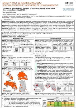
- 1. SSIE / ENAC / PROJET DE MASTER ANNEE 2015 SECTION SCIENCES ET INGENIERIE DE L’ENVIRONNEMENT Validation of OpenStreetMap road data for integration into the Global Roads Open Access Data Set (gROADS) 1 Laboratory of Geographic Information Systems (LASIG), EPFL / 2 Center for International Earth Science Infromation Network (CIESIN), The Earth Institute, Columbia University in the City of New York Author : Bogdan-Mihai Cîrlugea Advisers : Prof. François Golay 1 / Prof. Alex de Sherbinin 2 / Paola Kim-Blanco 2 Introduction Methods & Results Conclusion Background: gROADS v1 represents a global dataset that provides the best available open access road data by country, under a consistent and internationally accepted data model. A second version of gROADS sets the goal of improving the original dataset by including other freely available, more accurate and complete datasets. In this context OpenStreetMap (OSM) represents the best open dataset available for improving gROADS v1. Country Criteria Ingestion decision Completeness Positional Accuracy Attribute structure Improvement RMSE < 50m Improvement Liberia NO YES NO NO Guinea NO YES NO NO Ghana YES YES YES YES Senegal NO YES NO NO Problem: Being a Volunteered Geographic Information product, OSM has no systematic quality control. Moreover previous studies have shown that OSM’s quality is highly variable. A fast comparative assessment of the quality of OSM data is impossible due to the lack of reference datasets. Objectives: Development of a set of diagnostics that can give a sense about the overall quality of OSM and a decision framework that could determine if OSM country road networks should be ingested into gROADS and replace the existent data. Country Erroneous predictions of incomplete regions Discrete classification (%) Regression models (%) Liberia 21% 31% Guinea 0% 11% Ghana 22% 23% Senegal 0% 0% Country Total RMSE (m) Urban RMSE (m) Rural RMSE (m) Liberia 31.57 7.97 43.93 Guinea 11.50 8.06 13.30 Senegal 7.46 4.10 8.99 Ghana 9.47 9.90 9.03 Process: Country by country assessment of different quality aspects of gROADS & OSM road networks. Analysis platform: R programming, ArcGIS, PostGIS Case study: Liberia, Guinea, Ghana & Senegal Attribute structure Completeness assessment Positional accuracy Countries Unspecified / Unclassified roads gROADS (%) OSM (%) Liberia 20.98 32.89 Guinea 9.58 23.57 Ghana 98.37 14.94 Senegal 9.18 14.80 The ingestion decision can be made based on a comparison between OSM and gROADS on the three described quality criteria. OSM is not always superior to gROADS v1 for low income countries. Only one country out of four is suitable for ingestion: Ghana. The need for a systematic validation process was reinforced. If improved, the exploratory completeness assessment could serve as a tool for the OSM community, to guide further mapping. Method: Determine the proportion of features that lack classification. Compute the length of ‘unclassified’ (OSM) / ‘unspecified’ (gROADS) features out of the total road network length (%). Method: Compare position of OSM road intersections with the position of road intersections digitized on imagery (ground truth). Provide one RMSE value for each country. Imagery: Google Earth Sample size: 100 intersections Sampling scheme: 10 random admin units (urban + rural) & 10 random intersections in each. Results: All cases present an RMSE suitable for gROADS (<50m). Assumption: Presence/absence of roads is influenced by 3 quantifiable variables: Population, Wealth, Terrain Variability. If true, the 3 variables can be used to predict regions with missing roads in OSM Identify suitable datasets: GPW (population density), DSH survey (wealth index), STRM-1 Arc Second Global (terrain variability) Aggregate datasets: Subnational admin units 2 (provided by GPW dataset) Asses correlation: Pop. density, Wealth & Road density -> highly correlated Develop prediction methods: Discrete classification & Regression model Validate predictions: Visually inspect the predicted regions against Google Earth Imagery. If no roads are missing, prediction is considered erroneous. Workflow 1. Discrete classification: Classify admin units as Low - High road density, population density & wealth using the median of each variable. Tag as incomplete regions with Low road density but High pop. density & High wealth. 2. Regression model: Predict road density with pop. density and wealth using a Spatial Durbin regression model. Tag as incomplete regions with high negative residuals (<25%). Exploratory method Results: Some patterns can be spotted but the two methods have generally different results. The number of erroneous predictions is high. Comparative method Results: Only in the case of Ghana, OSM represents an improvement over gROADS v1. Results: OSM mapping is concentrated in urban regions. Only for Ghana OSM represents a significant improvement. Method 1: Compare the total length of equivalent road networks in OSM and gROADS. Country OSM road network length (km) gROADS v1 road network length (km) Liberia 32’457 25’205 Guinea 101’733 100’401 Ghana 57’613 22’752 Senegal 41’622 71’375 Method 2: Compare at admin unit level the road density (road length / area) of equivalent road networks in OSM and gROADS. Discrete classification Regression model 2016